A living tide that unveils a hidden road
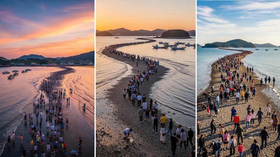
Twice each year, the sea between Jindo Island and little Modo Island falls away and a dark strip of sand and pebbled mud rises into view. For a brief window that feels stretched in time, thousands step off the shore and walk a route that is usually underwater. Locals call it the Miracle Sea Road. Visitors call it unforgettable. Scientists call it a textbook extreme low tide. The Jindo Sea Parting sits at the meeting point of science, story, and celebration, which is why it draws crowds from across South Korea and far beyond.
In its fullest form, the exposed path runs about 2.7 to 2.9 kilometers in length, roughly 1.7 to 1.8 miles, and about 40 to 60 meters in width. Water lingers at ankle depth in places and gentle ripples fold in from both sides. The route links the village coast of Jindo to the shore of Modo. For about 40 to 60 minutes, usually long enough to reach Modo and turn back, the route becomes a living footpath as families, elders, and children stroll out alongside foragers hunting for razorshell clams, crabs, and bits of seaweed.
While residents have watched the sea open for generations, the world learned about it in the 1970s when a French ambassador compared it to the biblical parting of the Red Sea. The nickname Moses Miracle stuck, and the county began building a festival around a predictable natural cycle. Today the crossing is the heart of a wider celebration with music, rituals, food stalls, and quiet moments on an ocean floor that rarely sees sunlight.
Where and when the sea opens
The sea road appears during the year’s largest tidal ranges. The most reliable windows arrive in spring, usually between late March and early May. A second window can arrive in early autumn, often in September or October. Predictions are based on tide tables and the geometry of this corner of South Jeolla Province. On the best days, there can be a morning opening near dawn and an evening opening near sunset.
The county runs its signature Jindo Miracle Sea Road Festival in spring when several days of extreme low tides arrive in succession. In 2025, the festival ran from March 29 to April 1, with guided entries onto the sea floor and cultural stages onshore. Outside festival dates, the sea can still open, especially from March through June when two or three extreme low tides line up. Autumn openings tend to be less frequent and can feel wilder, with fewer crowds and crisp air. The exact timing shifts by the day because the Moon and Sun set the clock.
Plan for a crossing time of about one hour. Tides swing back quickly. If the water has not dropped to the expected level or wind drives swell into the channel, the path may not fully form. That uncertainty is part of the experience and a reason to check local tide charts and heed on site announcements.
The science: why the Jindo Sea parts
The spectacle is not a wall of water pulling back. It is the entire sea level dropping to reveal a buried ridge. Gravity from the Moon and Sun lifts and lowers the ocean in predictable rhythms. Those rhythms stack in complex ways that coastal scientists call tidal harmonics. When several cycles peak together, the low tide can reach an extreme, especially at places shaped to magnify the effect.
Tidal harmonics in plain language
Think of the tide as a set of regular beats. There is the daily cycle as the Earth spins under the Moon. There is the monthly cycle tied to the Moon’s phase and distance from Earth. There is the annual cycle that depends on the tilt of Earth and the Sun’s pull. Each cycle has its own tempo. At Jindo, the beats sometimes line up to create an unusually low tide, like a song that hits a powerful note when all the instruments play together.
Why a path forms in this exact spot
The channel between Jindo and Modo sits beside the Myeongnyang Strait, a narrow throat of water known for fierce currents. That strait funnels tidal energy in and out of the region. Between the two islands the seabed has a gentle saddle where water tends to slow. Over time, waves and currents dropped sand and shell fragments along that line. The result is a ridge wide enough for an army of rubber boots. When the sea recedes, that ridge clears the surface first, and for a short stretch it becomes a road with glittering pools on either side. Local agencies say the crossing is safest when tide charts show levels around minus 30 on the local scale, a simple shorthand for a very low sea.
Legend, memory, and identity on Jindo
Jindo’s origin story for the sea road centers on Granny Bbyong. According to the folktale, tigers forced villagers to flee to Modo, and one elderly woman was left behind. She prayed to the sea deity for a path. The waters opened and a glittering rainbow road appeared. She crossed and her family met her on the far shore. On the Jindo waterfront, a statue of the woman and her tiger recalls that mix of fear, faith, and relief.
Myth has never lived here alone. The surrounding straits are a stage for Korean history. Admiral Yi Sun sin won an unlikely victory through the nearby Uldolmok channel in 1597, a place sailors still call the Roaring Channel for its tide races. Jindo Island is also home to the loyal Jindo dog, a national treasure with a museum and research center. The sea road sits inside that circle of culture, memory, and survival.
Inside the Jindo Miracle Sea Road Festival
Festival days begin with tide briefings and a slow procession toward the water. Drummers shake the air. Seniors in traditional dress lead shamanic rites that ask the sea for safe passage. Families lace up boots. Lights flicker on seafood stalls where steam curls above abalone, spicy crab stew, and griddled pancakes. When the sirens sound and staff swing the rope lines aside, the crowd flows onto the sand.
On shore and into the night, stages mix old and new. Expect Jindo Arirang folk singing, the circle dance known as Ganggangsullae, and the Ssitgimgut cleansing ritual. Expect ssireum wrestling, processions with torches, K pop sets, and a late night dance stage. Dog lovers gather for Jindo breed shows. The final evening often ends with fireworks over dark water.
What happens on the sea road
Once on the route, a tide of people fans out across gleaming mud. Kids splash in shallow pools while elders stoop to feel the texture of the seabed. Local residents dig for clams and crabs with small rakes. Visitors snap photos with water folded on each side of the line. Guides keep people moving and remind late walkers to turn around in time to beat the returning water.
Planning your visit
Jindo County sits off the southwest corner of the Korean Peninsula in South Jeolla Province. The island links to the mainland by the twin Jindo Bridge, a pair of cable stayed spans. Travelers from Seoul often take a direct express bus to Jindo Bus Terminal, a ride of about four to five hours. Another option is train service to Mokpo, then a local bus or taxi across the bridge. The closest major airport is Gwangju International, about ninety minutes away by car.
Many visitors join organized day trips timed to the tide, departing very early from Seoul and other cities. Independent travelers should consult official tide forecasts before setting plans. On the best dates there can be two chances to walk, at dawn and near sunset. Allow time to park, weave through festival grounds, and reach the shoreline. Arrive early on festival days. Crowds pack the waterfront and the narrow approach roads.
What to bring
Footing can be soft and gritty. Wear calf or thigh boots if you have them. If you prefer sneakers or sandals, expect wet feet. Bring gloves if you plan to forage, since sharp shells can hide in the mud. Pack a towel, sunscreen, a hat, sunglasses, a change of socks, a reusable water bottle, and a phone charger. Check weather and dress in layers. The wind can bite even in spring sunshine.
- Check official tide times for the day you plan to visit
- Arrive at least one hour before the predicted low tide
- Waterproof boots or sandals you can rinse
- Towel, spare socks, and a small trash bag for wet items
- Sunscreen, hat, and sunglasses
- Gloves for clam digging and a small rake if allowed
- Cash for food stalls and local taxis
- Keep both hands free on the walk, use a small backpack
If you plan to cross to Modo, budget time to return. The tide rises faster than most first time visitors expect. Local volunteers enforce turnaround points and will ask stragglers to head back well before the water reaches waist height.
Safety, etiquette, and conservation
The crossing feels calm, yet it takes place in a dynamic channel. The nearby Uldolmok throat can drive currents that are among the fastest in Asia. The weather adds its own variables. Respect barriers and instructions from local staff. If sirens sound, move toward shore without delay.
Treat the route as a living habitat. Small octopuses, fish fry, sea snails, and crabs share the flats. Step with care. Do not collect living animals unless you know the rules. Pack out every scrap. Photography is welcome, but do not block the flow of people on narrow stretches.
- Study tide charts and festival notices the day before you go
- Follow rope lines and volunteers, do not venture off the marked path
- Watch children closely and keep groups together
- Plan a clear turnaround time so you are back on shore before the tide turns
- Beware of slippery rocks and broken shells
- Do not drive vehicles onto the flats
- Keep noise down during shaman ceremonies and traditional songs
Beyond the sea road: what else to see
Modo Island, reached by the crossing, offers a quiet shoreline, farm plots, and simple village life. Many walkers step ashore, pause for a panoramic photo, then turn back toward Jindo before the water returns. Outside the parting, visit by local ferry.
On Jindo, stop by the Jindo Dog Museum to learn about the island’s famous hunting breed. Explore the Namdo Traditional Art Museum and local galleries. Drive the Sebang Coastal Road for sunset. At Uldolmok, feel the roar of the Myeongnyang Strait from the lookouts above the bridge, then visit nearby exhibits that honor Admiral Yi Sun sin and his tactics.
If you have more days, base yourself in Mokpo. A short drive away, Yudal Mountain gives a sweeping view over islands and channels. The city has a natural history museum, parks, and classic seafood markets. Many spring festival tours bundle a Mokpo harbor cruise with the Jindo crossing.
What to Know
- The Jindo Sea Parting exposes a walkable route between Jindo and Modo for about 40 to 60 minutes
- The path is roughly 2.7 to 2.9 kilometers long and about 40 to 60 meters wide
- Most crossings happen in spring, with a second window often arriving in early autumn
- The main festival typically runs in spring and in 2025 took place from March 29 to April 1
- Check official tide tables, then arrive early, the tide returns quickly
- Wear waterproof boots or shoes you do not mind soaking, shells and stones can be sharp
- Reaching Jindo: 4 to 5 hours by bus from Seoul, or train to Mokpo and local transfer, Gwangju International Airport is about 90 minutes away by car
- Local culture features Jindo Arirang, Ganggangsullae, Ssitgimgut, ssireum, and Jindo dog shows
- The phenomenon is caused by extreme low tides and a sediment ridge aligned by local geography and tidal harmonics
- Weather and sea state can limit the opening, follow on site guidance and safety cues