A Highway That Speaks to Drivers Through Their Senses
If you have ever slammed the brakes because a deer, boar, or stray dog suddenly appeared in your headlights, you understand the deadly problem of highways cutting through wildlife habitat. Animals do not read warning signs, and speed cameras cannot prevent collisions that happen in fractions of a second. India is now testing a radically different solution on National Highway 45 in Madhya Pradesh. A stretch of asphalt has turned blood red. This is not merely paint. It represents a sophisticated attempt to protect both drivers and wildlife using behavioral psychology, tactile engineering, and a complete rethink of how roads interact with forests.
- A Highway That Speaks to Drivers Through Their Senses
- How the Red Surface Manipulates Driver Behavior
- Engineering Compatibility with Self-Driving Cars
- The Unseen Infrastructure That Makes It Work
- The Science of Wildlife Crossings
- Global Parallels: Chile Bets on Wildlife Corridors
- The Human and Animal Cost of Current Roads
- Measuring Success and Ensuring Maintenance
- A New Language for Highway Design
- Key Points
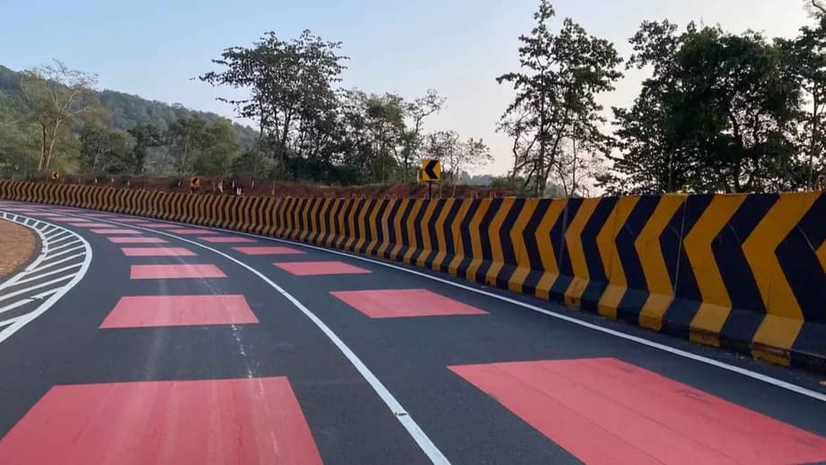
The National Highways Authority of India (NHAI), under the Ministry of Road Transport and Highways, has unveiled what it calls the countrys first table-top red marking on a national highway. The project covers an 11.96-kilometer stretch of NH-45 passing through the Veerangana Durgavati Tiger Reserve and skirting the Nauradehi Wildlife Sanctuary. At its core lies a 2-kilometer danger zone coated with a 5-millimeter hot-applied thermoplastic red surface layer. The bright crimson color and slightly raised texture are designed to trigger instinctive deceleration without harsh braking, vehicle damage, or driver discomfort. The road itself becomes the warning sign.
How the Red Surface Manipulates Driver Behavior
The psychology behind the red road is deliberate and grounded in sensory engineering. Red light travels at a long wavelength, making it inherently attention-grabbing compared to the white and yellow markings that motorists often learn to ignore. When combined with a table-top texture that creates mild tactile and audible feedback through tires, the design triggers subconscious slowing before the conscious mind processes the threat.
Vishal Gupta, Executive Director at Deloitte India, describes the intervention as a subtle nudge. Rather than distracting drivers, it functions as a psychologically powerful visual cue that signals entry into a danger zone without the sudden jolt of traditional speed breakers. The markings also help break the monotony of long drives, potentially reducing fatigue in tropical environments where highway hypnosis contributes to accidents.
For night driving, the thermoplastic incorporates glass beads that create reflectivity under headlamp illumination. The red surface glows brightly after dark, maintaining visibility in both dry and wet conditions. This addresses a critical vulnerability in wildlife corridors, where most animal-vehicle collisions occur during dawn, dusk, and nighttime hours when visibility is lowest and animal movement is highest.
Engineering Compatibility with Self-Driving Cars
Beyond immediate safety, the NH-45 project anticipates the future of automated transportation. As India prepares its highways for software-driven and sensor-led vehicles, questions arise about whether non-standard road colors might confuse Advanced Driver Assistance Systems (ADAS). Experts confirm that modern autonomous platforms do not rely on color recognition alone.
Abhishek Mohan, Chief Engineer for ADAS at Tata Technologies, explains that contemporary systems use edge detection, contrast analysis, reflectivity, and semantic interpretation supported by sensor fusion across cameras, radar, and LiDAR. From an ADAS Level 2 and 3 perspective, the red marking is largely compatible provided it does not obscure standard longitudinal lane markings. ADAS systems primarily rely on white and yellow lane lines for lateral control. Transverse colored treatments are generally interpreted as road-surface features rather than lane boundaries.
In rare cases where underlying lane paint is temporarily masked, the system may request driver takeover or disengage, which constitutes safe and expected behavior. The red marking emerges not as a constraint but as a forward-looking infrastructure intervention, provided it is supported by high-quality lane paint continuity and proper calibration standards. Azmathullah Mohammed, Senior Sales Director at Dassault Systèmes India, points to the importance of simulation-led development using platforms like CATIA SCANeR to validate such interventions virtually before physical deployment.
The Unseen Infrastructure That Makes It Work
Red paint alone cannot stop a collision if animals can still step onto the road. The surface treatment represents only the visible layer of a comprehensive safety system. NHAI has constructed 25 dedicated animal underpasses along the 11.96-kilometer corridor, positioned at documented wildlife movement locations. These tunnels allow tigers, deer, sambar, and jackals to cross beneath the highway without surfacing into traffic.
Continuous chain-link fencing, standing approximately eight feet high, runs along both sides of the highway. This barrier prevents animals from entering the roadway while guiding them toward the underpasses. The fencing integrates with the natural topography in deep cutting sections where the landscape itself forms a natural barrier. Cameras mounted on minor bridges monitor usage of crossing points, while solar lighting at bridges and junctions improves visibility without adding significant environmental strain.
Amritlal Sahu, an NHAI official associated with the project, emphasizes that underpasses help but cannot eliminate risk unless motorists also change their behavior. The red markings were introduced to plug persistent accident pockets where fencing and underpasses alone proved insufficient. The entire system operates under NHAI’s Green Highways initiative, aligned with the Ministry of Road Transport and Highways’ 2015 policy on environmentally responsible road building.
The Science of Wildlife Crossings
Research consistently demonstrates that wildlife vehicle collisions are not merely remote forest problems. In the United States, federal studies estimate between one and two million collisions occur annually between vehicles and large animals, creating safety hazards for humans and major sources of wildlife mortality. For some federally listed threatened species, road mortality ranks among the primary threats to survival.
A large meta-analysis of mitigation strategies reveals clear hierarchies of effectiveness. Fencing combined with crossing structures reduces large mammal roadkill by approximately 83 percent. Fencing alone achieves roughly 54 percent reduction. Critically, crossing structures without fencing show little detectable benefit, reminding planners that animals require guidance toward designated passage points rather than mere tunnels placed nearby.
Length and continuity determine success. Research published in Conservation Biology suggests fencing delivers at least 80 percent collision reduction when installed along stretches of 5 kilometers or more. Shorter fenced segments produce inconsistent results, with collision reductions ranging from zero to 94 percent and averaging just 52.7 percent. The NH-45 project, with nearly 12 kilometers of continuous fencing and multiple underpasses, meets the threshold for high effectiveness, though maintenance remains the quiet variable that determines long-term success.
Global Parallels: Chile Bets on Wildlife Corridors
India is not alone in pursuing wildlife-friendly infrastructure. In February 2026, Chile’s Ministry of Public Works announced a major Route 5 concession from Chacao to Chonchi on Chiloé Island, representing a $594 million investment across 126 kilometers. The project includes a new Pudeto River bridge of roughly 750 meters, additional bridges, pedestrian walkways, and service roads.
Buried within this infrastructure list lies a significant ecological commitment. The design incorporates seven wildlife crossings, also described as ecological corridors, specifically intended to protect the island’s natural environment. Construction is projected to begin in 2028 following detailed engineering and environmental impact assessment, with full operation expected around 2033. The Chacao-Chonchi highway concession represents one of the largest infrastructure commitments on Chiloé Island in recent decades, demonstrating that the integration of transportation and conservation has entered the mainstream of global infrastructure planning.
The Human and Animal Cost of Current Roads
While India lacks comprehensive national data on animal-vehicle collisions, available state-level figures reveal sobering patterns. In Punjab, direct animal collisions account for 53 percent of fatalities linked to such accidents. Madhya Pradesh, known as the Tiger State of India for hosting the highest number of tiger reserves in the country, has recorded 237 animal-vehicle collisions and 94 human deaths over the past two years alone.
As tiger populations rise in reserves like Veerangana Durgavati, animals increasingly push beyond protected boundaries onto highways that slice through traditional corridors. The NH-45 upgrade, built at a cost of Rs 122 crore and scheduled for completion by 2025, attempts to address this growing conflict. Beyond safety, officials anticipate the improved highway will support tourism and local economic activity following the reclassification of nearby wildlife zones.
Measuring Success and Ensuring Maintenance
The red road experiment will ultimately be judged by measurable outcomes rather than visual impact. Three metrics matter most: speed data through the marked zones, before-and-after wildlife collision counts, and monitoring evidence that animals are actually using the underpasses instead of searching for gaps in the fence. Solar-powered cameras already monitor minor bridges to track wildlife movement patterns and verify underpass utilization.
Maintenance poses the greatest threat to long-term effectiveness. A single break in the fence line, a clogged underpass, or vegetation encroaching on the red surface can transform a carefully designed corridor back into a lethal trap. The thermoplastic surface is designed for easy maintenance and replacement, and remains fully reversible if future upgrades become necessary. The minimal ecological footprint requires no alteration to pavement structure or drainage patterns, and generates less noise than conventional rumble strips.
A New Language for Highway Design
The NH-45 project signals a shift from purely transport-centric highway design to a more holistic safety model that integrates ecology, behavioral science, and vehicle technology. As next-generation vehicles move toward higher autonomy through advanced sensor fusion, road infrastructure can no longer be treated as static. Infrastructure and car manufacturers must collaborate to adapt roads for assisted driving.
If the Madhya Pradesh experiment proves successful, similar eco-sensitive road designs could appear on other national highways passing through forest and wildlife corridors across India. The country maintains over 150,000 kilometers of national highways, many of which intersect ecologically sensitive regions. The red road represents a rare moment where infrastructure pauses to acknowledge the life around it, suggesting a future where highways no longer assume the right of way but learn to share it.
Key Points
- India’s first table-top red road markings appear on NH-45 in Madhya Pradesh, covering a 2-kilometer danger zone with 5-millimeter thermoplastic surfacing designed to trigger instinctive driver deceleration.
- The project runs through the Veerangana Durgavati Tiger Reserve and includes 25 wildlife underpasses, eight-foot chain-link fencing, solar lighting, and monitoring cameras.
- Research indicates that fencing combined with crossing structures reduces large mammal roadkill by approximately 83 percent, while fencing alone achieves roughly 54 percent reduction.
- The design is compatible with ADAS and autonomous vehicle systems that rely on edge detection and contrast analysis rather than color recognition alone.
- Madhya Pradesh recorded 237 animal-vehicle collisions and 94 human deaths over the past two years, highlighting the urgency of wildlife-safe infrastructure.
- Chile is implementing similar strategies on a larger scale with seven wildlife crossings planned for a 126-kilometer highway concession on Chiloé Island.
- The project falls under India’s Green Highways Policy of 2015, with construction costs of Rs 122 crore and expected completion in 2025.