
A Three-Week Survey Reveals Hidden Passages
Twenty-six previously unknown caves have been documented in Vietnam's Phong Nha-Ke Bang National Park and surrounding areas, including a cavern with an underground waterfall dropping approximately 350 meters. The discoveries emerged from an international expedition conducted from March 21 to April 11, 2026, with results announced by park director Pham Hong Thai on April 24.
Contents
- A Three-Week Survey Reveals Hidden Passages
- International Specialists Worked With Local Guides
- Cha Ngheo's Waterfall Creates an Extreme Descent
- Thien Cung Preserves an Ancient River Route
- Seasonal Streams and More Accessible Caves
- What the Discoveries Reveal About Limestone and Water
- New Evidence for a World Heritage Landscape
- Tourism Possibilities Come With Limits
- Earlier Discoveries Show How Exploration Has Grown
- Connecting the Underground Map
- Key Points
Thien Cung Cave, the longest discovery of the expedition, stretches 4,206 meters through Sinh Ton Valley. Cha Ngheo Cave presents a very different challenge: a steep underground descent, an active waterfall and conditions that make it unsuitable for tourism at present.
The team examined 29 caves in total and surveyed more than 13.6 kilometers of passages. Twenty-six of the caves were new discoveries. Individual sites ranged from short vertical shafts to horizontal networks extending several kilometers, adding to a known cave inventory now exceeding 425.
The work covered the national park, its buffer zone and surrounding areas, primarily in the central provinces of Quang Binh and Quang Tri. Alongside the newly mapped chambers, explorers identified water connections between underground passages and surface rivers, helping explain how the landscape developed over millions of years.
Pham Hong Thai, the park's director, described the scientific and tourism value of the findings when announcing the results:
The discoveries affirm the exceptional value of the area's cave system. They also add important data for geological and geomorphological research, serving both scientific study and the development of sustainable tourism.
The findings expand knowledge of a landscape that remains incompletely mapped despite decades of exploration. Some caves offer possibilities for carefully controlled visits, while others contain hazards and sensitive environments that require strict protection.
International Specialists Worked With Local Guides
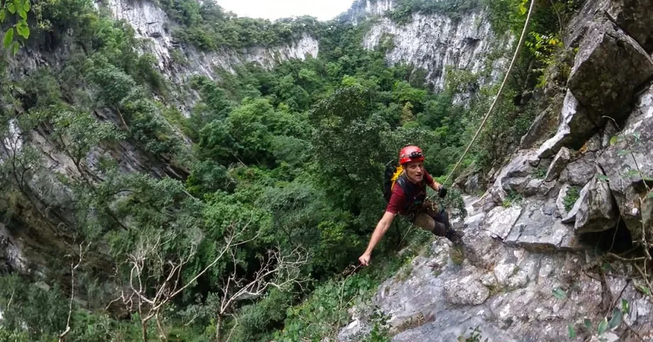
Ten cave experts from the United Kingdom, Australia, New Zealand and Hungary joined the expedition, working with local specialists under the coordination of the British Vietnam Caving Expedition Team. Howard Limbert, leader of the British Royal Cave Exploration team, led operations that required advanced climbing and rope techniques to reach previously inaccessible chambers.
Residents and guides from Kim Dien, Kim Phu and Son Trach communes helped locate entrances and navigate the terrain. Their knowledge of features that could signal hidden openings was essential in areas covered by dense jungle and difficult limestone formations.
The survey reached both core protected areas and buffer zones. Equipment included laser distance measurers, geological sampling tools and underwater mapping gear for the many subterranean streams encountered along the way.
Measuring a cave involves more than finding its entrance. The expedition recorded passage lengths, examined the shape of chambers and followed water routes where access allowed. Together, these observations revealed a landscape containing both deep vertical caves and extensive horizontal networks.
Cha Ngheo's Waterfall Creates an Extreme Descent
Cha Ngheo Cave lies in a strictly protected sub-zone of Kim Dien Commune. Its reported measurements include a length of 583 meters and a vertical depth of 751 meters. A near-sheer entrance drops approximately 350 meters before reaching the first flat section.
A stream supplied by forest runoff plunges through this shaft, creating a continuous internal waterfall. A waterfall of this scale is exceptionally rare in a cave environment and makes an already demanding descent more difficult.
Explorers needed extensive bolting and rope work to enter and move through the cave. Slippery surfaces and little light added to the challenge. Howard Limbert, who has spent more than three decades exploring caves internationally, described the conditions:
It is one of the most challenging caves I have encountered in over three decades of exploration.
Cha Ngheo is currently unsuitable for tourism. Its vertical drops and active waterfall mean access will likely remain limited to scientific exploration, while large sections remain unsurveyed and potentially hazardous.
The waterfall also gives researchers a way to examine how water travels from the forest into the limestone below. Scientists believe further exploration may reveal connections with larger aquifer networks, the underground systems through which water is stored and moves.
Thien Cung Preserves an Ancient River Route
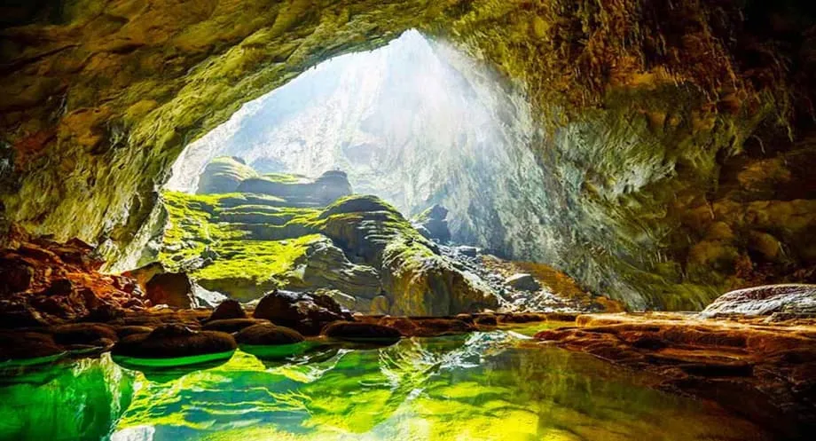
Thien Cung Cave offers a contrast to Cha Ngheo's steep descent. Located in Sinh Ton Valley, its passages extend for 4,206 meters, reaching widths of 80 meters and heights of 100 meters in places. Vast chambers contain striking stalactite formations.
The survey team identified Thien Cung as a likely ancient flow route of the Hang Toi River, with hydrological links to the Chay River system. These connections help explain how rivers have moved through the region's limestone over time.
Ancient rivers carved passages before changing course or moving to lower levels. Dry sections and sediment deposits left behind in Thien Cung preserve a geological record spanning thousands of years, giving researchers opportunities to study past climate conditions and erosion rates.
The cave's importance therefore extends beyond its size. Its passages can help geologists reconstruct earlier drainage patterns: where water once flowed, how it shaped the rock and how the underground river network changed.
Seasonal Streams and More Accessible Caves
Nuoc Lan Cave measures 2,721 meters and contains evidence of seasonal water flow. Conditions change through the year, making the cave valuable for research into karst hydrology, the study of how water moves through landscapes shaped by dissolving limestone.
Ma Dom Cave extends 1,257 meters. Light entering through its entrance shafts creates bands of illumination inside, adding another distinct feature to the expedition's discoveries.
Mo Roo Cave, at 515 meters, has relatively accessible terrain and scenic features. Authorities have identified it as a possible site for controlled adventure tourism, subject to conservation requirements.
In Kim Phu Commune, explorers also recorded a chain of three caves behind Ruc Mon Cave. Underground streams connect these caves, and one was considered suitable for adventure tourism. The linked passages suggest that places appearing to end may connect with wider underground networks.
Several entrances were found beyond the park's core zone with help from local residents. The discoveries show why exploration of buffer areas matters alongside work in the most strictly protected parts of the park.
What the Discoveries Reveal About Limestone and Water
Phong Nha-Ke Bang stands on some of Asia's oldest and most complex karst formations, with limestone strata dating back approximately 400 million years. Karst terrain develops as water wears away and dissolves rock, leaving features such as caves, underground channels and deep shafts.
The newly documented caves show different parts of that process. Some contain deep vertical shafts formed by collapsing ceilings. Others have long horizontal networks carved by underground rivers. The survey found strong cave development across both types of terrain.
Water continues to shape these environments. Nuoc Lan's seasonal flows and Cha Ngheo's waterfall provide opportunities to study active movement between the surface and the underground system, while Thien Cung preserves evidence of older river routes.
Understanding these patterns also matters to people living nearby. The same landscape contains surface water supplies used by local communities for agriculture and daily needs. Research into the movement of water can support protection of both those supplies and cave ecosystems.
The expedition's measurements and observations add data for geological research, which examines the rocks themselves, and geomorphological research, which examines how landforms develop. Together, they help explain the park's continuing geological evolution.
New Evidence for a World Heritage Landscape
Phong Nha-Ke Bang received UNESCO World Heritage status in 2003. An extension in 2015 recognized broader ecosystem values, alongside the geological importance for which the landscape was already known.
The new discoveries reinforce the site's outstanding universal value under criteria concerning geology, geomorphology and biodiversity. Deep shafts, large horizontal chambers and connected streams add to the evidence of the region's complex underground development.
The 2026 survey also demonstrates how much remains to be documented after decades of intensive study. More than 425 known caves represent a substantial inventory, yet the expedition continued to find previously unrecorded systems within the park and its surrounding areas.
Park authorities view the findings as an important step for research, conservation and heritage promotion. The scientific value lies in recording how these caves formed and how they function today, while their protection preserves the environments that made the discoveries possible.
Tourism Possibilities Come With Limits
Approximately 50 of the park's more than 425 known caves are currently open to visitors. Existing experiences range from accessible show caves, including Phong Nha and Paradise Cave, to exclusive expeditions into Son Doong, recognized as the world's largest cave.
Mo Roo is among the new sites with tourism potential because of its accessibility and scenery. One of the three caves behind Ruc Mon also offers possibilities for adventure visits. Nuoc Lan's seasonal water flows provide opportunities for research alongside any future visitor access.
Cha Ngheo requires a different approach because of its extreme vertical drops, active waterfall and difficult access. Sensitive caves remain subject to strict protection for scientific research, while the suitability of potential visitor sites must be assessed individually.
Park authorities plan detailed environmental impact assessments before opening new areas. Infrastructure development is to follow sustainability criteria established by UNESCO and national conservation guidelines. No opening date for any newly discovered cave was given.
Pham Hong Thai said any expansion of tourism must follow strict environmental guidelines. Models that limit group sizes, require certified guides and restrict access during sensitive seasonal periods offer ways to manage visits while protecting the underground environment.
Fragile stalactites and bat populations are among the features at risk from poorly managed access. Experience at other cave tourism sites worldwide has shown that uncontrolled visits can damage delicate formations and disturb bat colonies that are important to local ecosystems.
The expedition also recommended improvements to existing infrastructure, including adjustments to lighting at the Son Boi Cave cluster. The aim is to improve visitor safety while reducing ecological disruption.
Authorities must balance public access with preservation as they act on the recommendations. A cave that offers attractive scenery may still require limits on visitor numbers, timing or infrastructure, depending on its conditions.
Earlier Discoveries Show How Exploration Has Grown
The 2026 findings follow years of continuing exploration. In 2018, a similar expedition identified 44 new caves across Dan Hoa, Hoa Son, Trung Hoa and Thuong Hoa communes in Minh Hoa district, as well as areas in Son Trach and Quang Ninh districts.
Those discoveries brought the recorded total at that time to 405. The current inventory exceeds 425 mapped systems, and experts suggest that hundreds more could remain hidden beneath the jungle canopy.
Son Doong remains the region's best known example of what exploration can reveal. Discovered in 1991, it was fully explored in 2009 by the same British team. Guinness World Records recognized it in 2016 as the largest cave on Earth.
Son Doong contains an underground river system, its own internal weather patterns and stalagmites comparable in size to skyscrapers. Some passages are large enough to accommodate commercial aircraft. None of the latest discoveries matches that scale, but the 2026 expedition adds different forms of scientific value through deep shafts, seasonal streams and ancient river passages.
Several dates mark the development of exploration and recognition in the region:
- 1991: Son Doong Cave was discovered.
- 2003: Phong Nha-Ke Bang received UNESCO World Heritage status.
- 2009: The British team fully explored Son Doong.
- 2015: An extension recognized the World Heritage site's broader ecosystem values.
- 2016: Guinness World Records recognized Son Doong as the world's largest cave.
- 2018: An expedition identified 44 new caves, bringing the recorded total at that time to 405.
- March 21 to April 11, 2026: International and local specialists examined 29 caves and documented 26 new discoveries.
- April 24, 2026: Park director Pham Hong Thai announced the latest results.
Connecting the Underground Map
Future expeditions will likely focus on connections between known caves and deeper underground water networks. The three caves behind Ruc Mon, linked by streams, offer a specific example of how individual discoveries may form parts of a larger system.
Thien Cung's relationship with the Hang Toi and Chay river systems presents another research opportunity. Cha Ngheo's waterfall offers a different route into understanding how surface runoff enters deeper passages, although its hazardous, unsurveyed sections make further work demanding.
Improving exploration technology may help extend the map as researchers investigate these connections. The latest expedition already combined distance measurement, geological sampling and underwater mapping equipment to document passages that range from short shafts to networks several kilometers long.
The immediate task is to turn those findings into detailed research and conservation decisions. Environmental assessments will guide any new visitor access, while scientific work can continue building a fuller picture of the park's ancient rocks and active waterways.
Key Points
- An expedition from March 21 to April 11, 2026, examined 29 caves and documented 26 previously unknown caves in Phong Nha-Ke Bang and surrounding areas.
- Ten international specialists worked with local experts, guides and residents, surveying more than 13.6 kilometers of passages.
- Thien Cung, the longest discovery at 4,206 meters, contains vast chambers and evidence of an ancient river route.
- Cha Ngheo contains an approximately 350-meter underground waterfall. Its reported measurements include a length of 583 meters and a vertical depth of 751 meters.
- Nuoc Lan measures 2,721 meters, Ma Dom 1,257 meters and Mo Roo 515 meters.
- The known cave inventory exceeds 425, with approximately 50 caves currently open to visitors.
- Mo Roo and one cave behind Ruc Mon have tourism potential, while Cha Ngheo is currently unsuitable for visitors.
- Authorities plan environmental assessments before opening new areas, alongside continued research into cave connections and water movement.