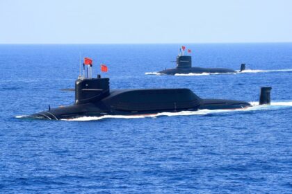
A New Arsenal for Maritime Artificial Intelligence
A Chinese military research team has released what it describes as the world’s largest publicly available dataset for ship detection, a resource that could transform how artificial intelligence identifies and tracks vessels at sea. Published in the peer-reviewed Journal of Radars in January, the dual modal ship detection (DMSD) dataset contains more than 2,000 paired images and nearly 20,000 annotated instances, offering an unprecedented training tool for drones, missiles, and surveillance systems operating in challenging maritime environments. The research team, comprising scientists from the Naval Aeronautical University in Yantai, Harbin Engineering University, and the Chinese Academy of Sciences’ Institute of Computing Technology, has made this collection freely available to the global research community. This release signals a significant investment in AI enabled naval warfare capabilities, specifically targeting the persistent technical difficulties that have historically plagued maritime target recognition.
The dataset addresses a critical vulnerability in modern naval combat systems: the inability to reliably identify and track moving vessels under contested conditions where traditional radar systems face jamming, deception, or degradation. By combining visible light imagery with infrared thermal signatures, the DMSD collection provides the raw material necessary to train machine learning algorithms that can maintain contact with targets through darkness, haze, and electronic interference. The scale of this release distinguishes it from previous maritime detection databases, offering researchers and defense contractors alike the voluminous, high quality training data necessary to develop next generation autonomous targeting systems.
Maritime environments present unique obstacles for automated detection systems that land based algorithms rarely encounter. Sunlight reflecting off water surfaces creates glare that blinds optical sensors, while rapidly shifting weather patterns and atmospheric distortion over long oceanic distances degrade image clarity. Cluttered backgrounds lacking distinct reference points further complicate the task of distinguishing vessels from their surroundings. These environmental realities mean that reaching the general vicinity of a naval target is often far easier than achieving the positive identification and precise tracking necessary for weapons engagement. The DMSD dataset specifically targets these challenges by providing annotated examples captured under varying sea states and lighting conditions, enabling AI systems to learn robust recognition patterns that persist despite environmental variability.
The Persistent Challenge of Finding Ships at Sea
Ship recognition at sea presents technical obstacles far more severe than object detection on land. Maritime environments are shaped by sunlight reflecting off water surfaces, rapidly shifting weather conditions, atmospheric distortion over long ranges, and cluttered backgrounds that lack distinct reference points. These factors systematically undermine the accuracy of optical and electronic classification systems. The difficulty of reliably identifying moving naval targets under contested conditions represents one of the most stubborn problems in modern military technology. Unlike static land based targets, ships move constantly through a dynamic medium, creating motion blur and changing orientation relative to sensors. Sea spray, fog, and haze further degrade image quality, while the homogeneous appearance of ocean surfaces offers few visual cues for automated systems to distinguish vessels from their surroundings. The motion of the observing platform, whether drone, aircraft, or satellite, adds additional complexity to the tracking task, introducing parallax errors and perspective shifts that confuse algorithms trained on stable terrestrial imagery.
Traditional radar systems, while powerful, face growing vulnerabilities in modern contested environments. Electronic warfare capabilities can jam, spoof, or degrade radar returns, creating uncertainty about target location and identity. This limitation has driven military researchers toward multi sensor fusion approaches that combine different detection modalities to create redundant targeting capabilities. The DMSD dataset directly addresses this need by providing training data that mimics the real world variability that AI systems must navigate to achieve reliable performance in operational conditions. Without such comprehensive training resources, autonomous weapons systems risk failing precisely when they are needed most, unable to distinguish between a warship and a civilian container ship or losing track of a maneuvering target during critical engagement windows.
How the DMSD Dataset Changes the Game
The DMSD dataset introduces a dual modal approach that pairs visible light imagery with infrared signatures for the same vessels under identical conditions. This pairing allows machine learning algorithms to learn correlations between how ships appear in standard photography and how they present thermally, creating more robust recognition models that function across diverse operational scenarios. Long Gao, corresponding author of the study and researcher at the Chinese Academy of Sciences, explained the comprehensive data collection methodology employed by the team.
“Data were acquired using [synthetic aperture radar or SAR], radar, visible light cameras, infrared cameras and other sensors mounted on shore based and airborne platforms.”
The scale of the annotation effort distinguishes this release from previous maritime detection databases. With nearly 20,000 annotated instances across over 2,000 paired images, the dataset provides the volume and variety necessary to train deep learning models without the overfitting problems that plague smaller collections. Each annotation includes precise bounding boxes and classification labels that enable supervised learning algorithms to develop the fine grained discrimination capabilities necessary to distinguish between vessel types, states of operation, and orientations. The inclusion of infrared imagery is particularly significant for nighttime operations, when visible spectrum cameras become ineffective but thermal sensors continue to detect the heat signatures of engines, exhaust systems, and hulls contrasted against cooler water backgrounds. This thermal data remains reliable even when vessels attempt visual camouflage or operate in conditions that render optical identification impossible.
Infrared Advantage in Contested Environments
Infrared sensors offer distinct tactical advantages over active radar systems in high intensity combat scenarios. Unlike radar, which must emit detectable electromagnetic signals to locate targets, infrared systems operate passively, measuring the natural thermal radiation emitted by objects without broadcasting their own presence. This passivity makes infrared detection inherently stealthy and immune to traditional electronic jamming techniques designed to confuse active sensors. The DMSD dataset’s inclusion of infrared imagery addresses a critical vulnerability window in naval warfare: the hours of darkness and conditions of low visibility that have historically offered protection against optically guided weapons.
The combination of visible and infrared data creates complementary capabilities that compensate for the limitations of each individual modality. Visible light provides fine detail for vessel classification when illumination is adequate, while infrared penetrates darkness, haze, and light fog to maintain detection capability when optical systems fail. By training on paired examples from both spectra, AI targeting systems learn to maintain track on vessels even when one sensor type loses contact due to environmental conditions or countermeasures. This redundancy is essential for autonomous weapons systems that must make engagement decisions without human intervention in time critical scenarios. The dual modal approach ensures that switching between sensor types happens seamlessly, maintaining continuous targeting solutions that would otherwise break during environmental transitions.
Real World Stakes: The Strait of Hormuz Incident
The practical importance of improved ship detection capabilities was illustrated starkly in February, when Iran claimed to have successfully struck the aircraft carrier USS Abraham Lincoln near the Strait of Hormuz. Washington dismissed the claim, stating that the missiles or drones involved did not come close to their intended target. This episode underscored the gap between launching weapons in the general direction of naval targets and achieving the precise identification and terminal guidance necessary for actual impact. The incident highlighted how even determined adversaries with capable weapon systems struggle to solve the final targeting problem in maritime environments where cluttered traffic patterns and environmental interference create confusion.
The Strait of Hormuz represents one of the world’s most strategically significant maritime chokepoints, with nearly a third of global LNG and oil shipments passing through its narrow waters. The difficulty of accurately targeting moving vessels in this congested environment, surrounded by commercial traffic and complex shorelines, demonstrates why datasets like DMSD carry significant geopolitical weight. As nations develop increasingly sophisticated anti access and area denial strategies, the ability to reliably identify specific warships among civilian traffic becomes a decisive factor in deterrence calculations and operational planning. The January release of this dataset takes on added significance given the region’s ongoing tensions and the demonstrated difficulty of maritime strikes against maneuvering capital ships. Accurate discrimination between military and civilian vessels prevents unintended escalation while ensuring that defensive systems engage actual threats rather than decoys or neutral shipping.
Military Applications and Strategic Implications
The institutional affiliations of the research team provide clear indication of the dataset’s intended applications. The Naval Aeronautical University operates within China’s military university system, training personnel for the People’s Liberation Army Navy and developing technologies for naval aviation operations. Harbin Engineering University maintains strong programs in underwater acoustics and marine engineering, while the Chinese Academy of Sciences conducts foundational research supporting national defense priorities. This collaboration between academic and military institutions reflects a broader pattern in Chinese defense research, where open publication of technical advances serves to accelerate innovation while establishing technical standards for the domestic defense industrial base. The involvement of these specific institutions suggests particular emphasis on applications for unmanned aerial vehicles and precision strike systems.
Analysts observe that by making the DMSD dataset publicly available, Beijing may be pursuing multiple strategic objectives simultaneously. Open sourcing the data accelerates the development of AI driven naval technologies by allowing civilian researchers to contribute improvements to detection algorithms. This approach also helps establish Chinese technical standards and research methodologies as global benchmarks in maritime AI applications. The dataset specifically supports the development of autonomous surveillance drones, precision anti ship missiles, and intelligent reconnaissance systems that can operate effectively in GPS denied or electronically contested environments where traditional navigation and targeting systems face degradation. By inviting global collaboration on this specific technical foundation, China positions itself at the center of future maritime AI development while maintaining control over the underlying data architecture.
Key Points
- China’s military research team has released the DMSD dataset, containing over 2,000 paired visible and infrared ship images with nearly 20,000 annotations
- The dataset supports development of AI targeting systems for drones, missiles, and surveillance platforms operating at night or in radar degraded environments
- Researchers from the Naval Aeronautical University, Harbin Engineering University, and Chinese Academy of Sciences led the project published in the Journal of Radars
- Dual modal detection combines visible light detail with infrared capability to overcome environmental challenges like glare, weather, and darkness
- Public release follows a Chinese strategy of open sourcing military relevant AI research to accelerate innovation and establish technical standards
- Maritime target recognition remains technically challenging, as demonstrated by recent incidents involving claims of strikes on US naval vessels