A Yellow Brick Road Appears on the Pacific Seafloor
In 2022, a remotely-operated vehicle gliding over an underwater mountain north of Hawaiʻi sent back a scene that looked straight out of a fantasy movie. On the summit of Nootka Seamount, inside the vast Papahānaumokuākea Marine National Monument, cameras revealed what seemed to be a neatly paved yellow brick road running across a dried lakebed on the seafloor. The scientists aboard the exploration vessel Nautilus jokingly referenced The Wizard of Oz and the lost city of Atlantis as the video streamed live online, with viewers around the world watching in real time as the vehicle inched along the strangely familiar pattern, more than a kilometer beneath the ocean surface.
- A Yellow Brick Road Appears on the Pacific Seafloor
- The Scientific Explanation Behind the Yellow Illusion
- A Surreal Landmark in One of Earth’s Biggest Protected Areas
- The Deep Ocean: A World We Barely Know
- Why a Viral “Road” Matters for Conservation
- The Path Forward: Deep-Sea Exploration and Protection
- The Bottom Line
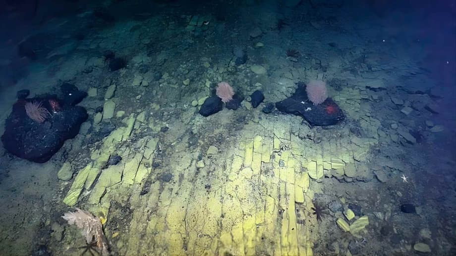
What initially appeared to be a pathway to a mysterious civilization was, in fact, nature performing an extraordinary geological illusion. According to the Ocean Exploration Trust team, the tiles are actually a fractured flow of hyaloclastite, a volcanic rock that forms when hot lava meets cold seawater during energetic eruptions and then settles on the seabed. Over time, heating and cooling stress broke the rock into sharp ninety degree cracks, creating a natural mosaic that looks like carefully placed bricks. In other words, no ancient engineers were involved—just physics and time operating over millions of years.
The discovery captured the public imagination not just for its unusual appearance, but because it made a very alien environment feel suddenly familiar. It’s the kind of image that sticks in your mind long after you close the browser tab—a testament to both Earth’s geological creativity and our human tendency to recognize patterns in nature.
The Scientific Explanation Behind the Yellow Illusion
Despite its striking resemblance to a paved pathway, the yellow brick road formation has a straightforward geological explanation. As the Nautilus team explained, the formation is actually a fractured flow of hyaloclastite rock. This type of volcanic rock forms during high-energy eruptions where many rock fragments settle to the seabed after coming into contact with seawater. The unique ninety-degree fractures are likely related to heating and cooling stress from multiple eruptions at this baked margin of the seamount.
Imagine it a bit like the surface of a good brownie—solid but can rise and fall with heat and cold, creating cracks in its surface. This ancient volcanic rock has behaved similarly, only over a much longer timescale. The distinctive yellow color comes from mineral deposits in the rock, which appear particularly vibrant under the ROV’s powerful lights.
“What may look like a ‘yellow brick road’ to the mythical city of Atlantis is really an example of ancient active volcanic geology,” explained the Ocean Exploration Trust in their official description of the discovery. This type of formation isn’t unheard of in geological terms—similar natural patterns can be found on land, like the Giant’s Causeway in Northern Ireland—but spotting it at such extreme depths made the sight all the more unexpected and captivating to the scientific team.
A Volcanic Formation with Scientific Value
The discovery of this formation goes beyond its visual appeal. Hyaloclastite deposits like those found at Nootka Seamount offer valuable insights into volcanic behavior, seafloor formation, and the physical conditions that shape underwater ecosystems. The same geological features that create dramatic visual effects also shape habitats for marine life.
Volcanic rock formations provide surfaces for organisms to cling to, hide within, or feed on. During the expedition, the team observed various creatures living along and around this unusual formation, including crinoids (sea lilies) that had made the strange “roadway” their home. These observations help scientists understand how life colonizes and thrives in seemingly inhospitable environments.
A Surreal Landmark in One of Earth’s Biggest Protected Areas
This particular seamount lies within Papahānaumokuākea Marine National Monument, a protected region that covers about 582,578 square miles of the Pacific Ocean. That is larger than all United States national parks combined and makes Papahānaumokuākea one of the largest marine conservation areas on the planet. To put that into perspective, if you could fold the entire state of Texas into the Pacific Ocean, it would still fit within this marine monument’s boundaries.
The monument was established in 2006 and expanded in 2016, encompassing ten separate marine conservation areas around the Northwestern Hawaiian Islands. It’s not just a vast expanse of water; it’s a complex ecosystem that includes coral reefs, deep-sea habitats, and important cultural sites for Native Hawaiian communities. Despite its massive size, however, only about 3 percent of its seafloor has been visually surveyed, highlighting how much remains unknown about this protected wilderness.
The Luʻuaeaahikiikekumu Expedition
The discovery of the yellow brick road occurred during the Luʻuaeaahikiikekumu expedition—”Ancient Seamounts of Liliʻuokalani Ridge”—which took place between April 7 and May 1, 2022. This mission was part of ongoing efforts to explore the relatively uncharted waters of this region. The Liliʻuokalani Ridge extends across the central Pacific, representing a chain of underwater volcanoes formed by ancient tectonic movements and mid-ocean ridge activity.
During the expedition, Nautilus completed 11 remotely operated vehicle dives between roughly 700 and 3,500 meters depth. The team mapped more than 28,000 square kilometers of seafloor and collected nearly 600 pounds of rock along with many biological samples. These data help scientists decipher how the chain of ancient volcanoes formed and how deep sea corals, sponges and microbes make a living on their rocky slopes.
Beyond the yellow brick road, the expedition made other fascinating discoveries. The team observed basalts coated with ferromanganese (iron-manganese) crusts from across different depths and oxygen saturations. They also found an interesting-looking pumice rock that almost resembled a sponge, collected samples of manganese oxide crusts, and even captured footage of a swimming headless chicken monster (a deep-sea swimming sea cucumber known for its translucent, ghostly appearance).
The Deep Ocean: A World We Barely Know
Even with viral moments like the yellow brick road discovery, humanity has barely begun to see the deep seafloor at all. A 2025 analysis led by researchers from the Ocean Discovery League, Scripps Institution of Oceanography and Boston University pulled together records from more than 43,000 deep sea dives carried out since the late 1950s. Their conclusion was stark: the deep ocean, defined as waters 200 meters or deeper, covers about 66 percent of Earth, yet less than 0.001 percent of the deep seafloor has been visually observed by cameras.
That fraction corresponds to an area roughly similar to the size of Rhode Island or about a tenth of Belgium. Everything else remains unseen, at least in terms of direct video or photographic coverage. So while the yellow brick road clip has circulated widely on social media, it represents only a pinprick in a vast, unmapped wilderness.
“We literally have better maps of the moon than of the ocean floor,” says Randy Kosaki, NOAA’s deputy superintendent for research at PMNM. This statement highlights the remarkable fact that despite our technological advances, we know more about the surface of our planet’s natural satellite than about the vast majority of our own planet’s seafloor.
Why the Deep Ocean Matters for Climate and Life
It might be tempting to think of that wilderness as distant and irrelevant to daily life. After all, it’s hard to picture a seamount while you are looking at your smartphone or checking the electric bill. The deep ocean, however, plays a central role in keeping the planet habitable. The Science Advances study notes that deep waters help regulate climate by absorbing most of the excess heat and a substantial share of the carbon dioxide created by human activities.
These regions also support enormous biodiversity, from microbial communities inside mineral crusts to corals, fishes and invertebrates that have never been named. Scientists estimate that millions of species remain undiscovered in the deep ocean, many of which could hold important biochemical secrets—from new medicines to clues about how life evolved on Earth.
At the same time, scientists warn that pressures on the deep sea are rising, including climate driven changes, pollution and interest in seabed mining. Without baseline information about what is down there, decision makers risk damaging ecosystems that we barely understand. The yellow brick road formation sits atop Nootka Seamount, which itself is believed to be over 50 million years old and is composed of materials that could be targeted for deep-sea mining.
Why a Viral “Road” Matters for Conservation
Missions like the Nautilus dives around Liliʻuokalani Ridge play an outsized role in both scientific discovery and public engagement. The expedition not only gathered geological and biological samples, it also streamed 4K video to anyone with an internet connection, and hosted dozens of live ship-to-shore conversations in Hawaiian, English and American Sign Language.
Moments such as the yellow brick road encounter turn abstract statistics into something people can see. A crackled sheet of volcanic rock suddenly becomes a symbol of both Earth’s creativity and our ignorance of its deepest places. That connection can inspire public support for protecting areas like Papahānaumokuākea and for investing in exploration that includes local and Indigenous voices.
The Ocean Exploration Trust, which operates the Nautilus expedition, incorporates cultural elements into their work. During the Luʻuaeaahikiikekumu expedition, they had a community cultural liaison who led the incorporation of Hawaiian protocol throughout the mission. The expedition’s name itself holds significance—Luʻuaeaahikiikekumu relates to Hawaiian traditions and cultural values associated with ocean exploration.
Bridging Science and Culture
This cultural approach to ocean exploration is increasingly important as scientists and indigenous communities work together to understand and protect marine environments. The expedition team included science communication fellows, science and engineering interns, and a guest educator from PMNM. This team helped host a record number of 114 ship-to-shore live interactions, reaching about 3,450 learners from across the world.
Additionally, cross sections of geologic samples collected during the expedition were planned to be displayed at PMNM’s Mokupāpapa Discovery Center in Hilo, Hawaiʻi, with the center using Hawaiian language materials developed to increase deep-sea science formal education efforts. This blending of Western science with indigenous knowledge creates a more holistic approach to ocean exploration and conservation.
More than 70 media stories ran about the expedition online, in radio, and on broadcast television by international media. Live video from the expedition received 582,000 views while produced video highlights garnered over 2.9 million views. This kind of public engagement is crucial for building support for ocean conservation efforts and for inspiring the next generation of scientists and explorers.
The Path Forward: Deep-Sea Exploration and Protection
The discovery of the yellow brick road formation serves as both a scientific curiosity and a call to action. The formation may not lead to Oz or Atlantis, but it does point toward a future where the deep ocean is less of a mystery and more of a shared responsibility. As we learn more about these deep-sea environments, we also become better equipped to protect them.
The same expedition that discovered the yellow brick road mapped a total of 28,559 square kilometers (11,027 square miles) of seafloor using the multibeam system on Nautilus, including 23,456 square kilometers (9,056 square miles) within the U.S. Exclusive Economic Zone. This mapping data helps scientists understand the geological structure of the region and identify areas that might need special protection.
In practical terms, every mapped ridge and every documented community of sponges or corals helps managers decide where human activities should be restricted and where they might be allowed with caution. The more we see, the better chance we have of avoiding irreversible harm to these fragile deep-sea ecosystems.
The Future of Ocean Research
Looking ahead, ocean exploration is likely to become increasingly accessible through technology and international collaboration. The Ocean Discovery League, which helped compile statistics on deep-sea exploration, is one organization working to democratize access to ocean research. They emphasize that only about 19 percent of dives have taken place in the high seas, which cover 58 percent of the ocean’s surface, pointing to the need for more global exploration efforts.
New technologies continue to push the boundaries of what’s possible in deep-sea exploration. Advanced ROVs can stay underwater for longer periods, collect more sophisticated samples, and provide higher-resolution imagery than ever before. Autonomous underwater vehicles can map larger areas more efficiently, while environmental DNA analysis allows scientists to detect species without ever seeing them directly.
As these technologies advance, we can expect to see more discoveries like the yellow brick road—natural phenomena that capture the public’s imagination while providing valuable scientific insights. Each such discovery reminds us that the deep ocean is not just a place of mystery, but a vital part of our planet that deserves our attention and protection.
The Bottom Line
- The “yellow brick road” discovered at Nootka Seamount is a natural geological formation of fractured hyaloclastite rock, not a man-made structure
- The formation features sharp ninety-degree fractures created by heating and cooling stress from multiple volcanic eruptions
- Located in Papahānaumokuākea Marine National Monument, the discovery took place during the Luʻuaeaahikiikekumu expedition in 2022
- Despite its massive size, less than 3% of the marine monument’s seafloor has been visually explored
- Deep ocean exploration is crucial for understanding climate regulation, biodiversity, and effective conservation strategies
- The discovery highlights the importance of combining scientific research with cultural perspectives and public engagement
- New technologies and international collaboration are key to advancing our understanding and protection of deep-sea environments