A turning point after deadly floods
Bali is moving to freeze the conversion of productive rice fields into hotels, villas, and other commercial projects after deadly floods spotlighted the costs of unchecked building. Provincial leaders say new permits to convert agricultural land will stop in 2025, and Indonesia’s land ministry has warned the island to restore protected farmland to national standards or face legal consequences. The shift is designed to protect lives, stabilize water systems, and preserve the rice paddies that shape both Bali’s identity and its food supply.
- A turning point after deadly floods
- What the law requires and where Bali falls short
- Why farmland conversion accelerates floods
- The future of tourism growth under tighter land controls
- Food security and the subak at stake
- Can Bali add 6,000 hectares of rice fields?
- Enforcement and local coordination
- What residents and builders can do now
- Key Points
At the center of the push is a shortfall in protected agricultural zones. Agrarian Affairs and Spatial Planning Minister, who also heads the National Land Agency, Nusron Wahid, endorsed Bali’s moratorium and instructed local authorities to add approximately 6,000 hectares of rice fields. The target includes around 4,000 hectares to replace fields already lost to development and another 2,000 hectares to meet minimum protection thresholds.
Two designations frame the debate. Sustainable Agricultural Land (LP2B) covers the rice fields that should remain in farming. Sustainable Food Agriculture Zones (KP2B) add reserves and supporting infrastructure such as irrigation, storage, and farm roads. National rules expect provinces to lock in at least 87 percent of rice field area as LP2B and 90 percent for KP2B. Bali stands at about 62 percent for LP2B and 83 percent for KP2B, far below the benchmarks the central government set to guard food security.
The legal stakes are clear. Under Indonesia’s 2009 Sustainable Agricultural Land Law, illegal conversion of protected farmland can bring up to five years in prison. The ministry argues that creating new rice fields would bring the island back into compliance, help legalize past conversions that did not meet the rules, and restore functions that reduce flood risk. Officials are also urging residents and developers to prioritize non productive land for housing and to consider vertical housing to limit sprawl into green space.
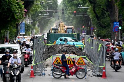
Scrutiny of land use has intensified after floods and landslides in September killed more than a dozen people and damaged homes and public facilities. Environmental officials have linked the disaster to a mix of heavy rain, poor waste management, and unregulated construction on former paddies and hillsides. Government figures indicate Bali has lost several hundred hectares of forest in the past decade, which reduces the island’s ability to absorb water during extreme downpours.
What the law requires and where Bali falls short
To understand the urgency, it helps to decode the acronyms. LP2B is land set aside for permanent agriculture. It is ring fenced to keep it in farming so that provinces preserve a base of rice production. KP2B is broader. It includes farmland plus land for reserves, irrigation canals, reservoirs, farm roads, and other facilities that keep agriculture viable. Provinces must meet the national floor for both categories, then keep those shares stable in their spatial plans.
Bali is out of alignment on both counts. The island protects only about 62 percent of its rice fields as LP2B and about 83 percent for KP2B. The gaps explain why the land ministry is pressing the province to map 6,000 hectares of new rice fields. Hitting that target would restore Bali’s ratios and reduce the risk that local governments or landowners face penalties for illegal conversion within protected zones.
Adding new rice fields does not simply mean planting on any open plot. Authorities need to identify contiguous areas that connect to irrigation networks, avoid flood prone slopes, and can be serviced without fragmenting habitats. If done well, the program would replace some of the paddies that have been paved over while also preserving the infrastructure that makes farming viable, including the centuries old canals that support Bali’s communal water system.
Why farmland conversion accelerates floods
Rice fields, forests, and wetlands work like sponges during heavy rain. The soil and root systems slow the water, spread it across terraces, and allow a portion to soak in. Concrete and roofs do the opposite. When paddies give way to villas and asphalt, more rain turns into fast surface runoff that races downhill. On steep slopes, clearing trees or terracing without proper drainage can trigger landslides. If canals and drains clog with trash, water has nowhere to go but into streets and homes.
Balinese agriculture evolved to manage these risks. The subak, a community managed irrigation system recognized by UNESCO, synchronizes planting cycles and water sharing across entire watersheds. The system relies on intact canals, terraced paddies, and shared rules that limit sudden changes in land use. When paddies are carved into plots for buildings, subak channels are severed. Water that once moved slowly across terraces is redirected into pipes, culverts, or parking lots that cannot absorb a cloudburst.
Officials say the island’s green cover is now too thin to buffer extreme rain. The Environment and Forestry Ministry has pointed to critical river basins, including the Ayung, where forest cover has fallen far below the minimum 30 percent that watershed experts recommend to stabilize flows. In parallel, uncontrolled building on former rice fields has reduced the area available to absorb runoff. Trash washed into rivers during storms has multiplied the risk by blocking watercourses.
After the floods, Environment and Forestry Minister Hanif Faisol Nurofiq urged Bali to stop further land conversion and treat environmental safeguards as a core part of its tourism policy. He underlined the stakes during meetings with provincial leaders, saying the island could not withstand repeated disasters if development continued to swallow green space.
The minister said: “I really hope he will immediately stop the land conversions in Bali. This is extremely important.”
Scientists expect heavy rain events to become more intense as the climate warms. Warmer air can hold more moisture, which means storms are capable of dropping more water in a short time. Where forests and rice fields have been replaced by buildings, floodwaters rise faster and to higher levels. That is why policymakers are now linking farmland protection to disaster risk reduction as well as food policy.
The future of tourism growth under tighter land controls
Bali’s plan does not end tourism. It changes where and how projects are built. The province will stop issuing permits that convert productive paddies to hotels, restaurants, and villas. Local leaders say existing projects that already hold valid approvals can continue, but new commercial projects will be steered away from farmland. A joint technical review of spatial plans is underway to make sure development maps reflect the moratorium and to update the environmental baseline.
Governor I Wayan Koster has framed the shift as a long term commitment that aligns with Bali’s century plan. He has instructed regents and mayors to hold the line on farmland conversion while the province completes flood response and planning updates.
Governor Koster said: “Starting this year, there is already an instruction to all heads of districts and mayors across Bali. After handling the floods, we will meet again to ensure no more permits are issued for hotels, restaurants or other facilities on productive land, especially rice fields. Starting this year, the land conversion ban will align with Bali’s 100 year plan. From 2025 onward, no productive land can be converted into commercial facilities.”
For developers, the new policy favors projects on already developed sites, vacant urban parcels, and non productive land that do not disrupt irrigation networks. For tourism operators, it protects the rice landscapes that draw visitors and support cultural offerings. For residents, it should reduce the pace of construction in flood prone corridors and on steep hillsides. The goal is a clearer separation between farming areas and built up zones, backed by permits that reflect watershed limits.
Tourism remains a pillar of Bali’s economy, and provincial leaders have signaled that growth must be balanced with environmental protection. They argue that protecting paddies and forests is not a constraint on tourism, it is an investment in the scenery, water, and cultural assets that keep visitors returning.
Food security and the subak at stake
The land ministry’s push is also about rice. Indonesia has prioritized food self sufficiency to shield households from global price swings and supply shocks. Bali’s contribution is modest compared with Java or Sumatra, but the island’s paddies serve local markets, stabilize prices in surrounding regencies, and underpin livelihoods. When rice fields turn into villas, that food and income disappear, and the province becomes more dependent on shipments from elsewhere.
Keeping irrigated land in production takes more than preserving plots. It requires protecting the subak canals and coordination between upstream and downstream communities. Subak councils decide planting schedules, share water during the dry season, and maintain the physical channels that make terraced farming possible. The network only functions if paddies remain contiguous and the canals are not severed by walls, roads, or restaurants built across the channels.
Large infrastructure proposals have also raised red flags. Road projects can unlock economic value, but if routes cut across rice terraces, dozens of subak nodes can be disrupted at once. Authorities say the new farmland protection rules will force closer review of alignments and require mitigation where agricultural land or irrigation structures are affected. The aim is to maintain the integrity of the network that moderates floods, sustains agriculture, and anchors Balinese cultural life.
Can Bali add 6,000 hectares of rice fields?
Meeting the target set by the land ministry will not be simple. New rice fields need water, soil preparation, access roads for farm machinery, and connections to existing irrigation networks. Some restoration can be achieved by reactivating fallow plots, re contouring terraces, and reopening irrigation lines that were closed during past conversions. Other gains may come from land swaps that reclassify suitable non productive land for farming while steering new housing to already urbanized areas.
Where to focus recovery is becoming clearer. Data compiled by the National Land Office show that from 2019 to 2024 Bali lost more than 6,500 hectares of rice fields to other uses, a decline of roughly 1.5 percent per year. The municipality of Denpasar recorded the steepest drop, losing nearly four in ten of its rice fields over six years. Gianyar ranked second by share lost. Tabanan, which still has a large farming base, saw smaller declines in that period. The pattern suggests restoration will be most difficult in dense urban regions and more feasible where farmland still forms large continuous blocks.
Where could new fields be created
Officials are likely to look first at areas where irrigation infrastructure remains intact, where water supply is reliable, and where land consolidation can yield connected terraces rather than isolated pockets. That points to regencies with strong agricultural footprints, such as Tabanan, and to buffer zones around existing paddies in Badung and Gianyar. Mapping will also have to consider erosion risk and the capacity of catchments to handle heavier rain.
Enforcement and local coordination
Bali’s moratorium will only work if district governments enforce it consistently. The 2009 law gives prosecutors tools to target illegal conversion inside protected zones, with penalties that include jail time. Yet prevention will likely matter more than punishment. The province plans to tighten permits, publish clearer zoning maps, and bring regents, mayors, and subak councils into the same process so that farmland boundaries are respected in every approval.
Officials have also encouraged a shift in housing patterns. They are urging residents and builders to choose non productive land for new homes and to consider vertical housing where appropriate. Taller buildings in already urbanized areas can absorb growth without spreading into green space. Where construction proceeds near waterways, stormwater standards such as retention ponds and infiltration wells will be required to slow runoff and reduce flooding.
What residents and builders can do now
While the province finalizes rules, there are immediate steps that can reduce risk and support the new policy. These steps improve the odds that projects win approval and that neighborhoods are safer during heavy rain.
- Check zoning before buying or building. Confirm whether land is inside LP2B or KP2B and whether it supports subak channels or reservoirs.
- Build on non productive land and avoid slopes and riverbanks that are prone to erosion and flash floods.
- Design for water. Include retention ponds, vegetated swales, and infiltration wells so more rain is stored on site.
- Connect to the subak system. Where projects are near canals, work with subak councils to protect and, if needed, reroute channels without disrupting flow.
- Reduce waste leakage. Keep construction debris and household trash out of waterways and drains to prevent blockages during storms.
- Consider vertical housing in urban areas to meet demand without consuming green space.
- Plan for climate. Expect more intense rain events and size drainage accordingly.
Key Points
- Bali will stop issuing permits that convert productive rice fields to commercial projects starting in 2025.
- The land ministry says Bali must add about 6,000 hectares of rice fields to meet national protection standards.
- Protected farmland shares are below target, with LP2B at about 62 percent and KP2B at about 83 percent.
- Illegal conversion of protected farmland can bring up to five years in prison under the 2009 law.
- Officials link recent deadly floods to heavy rain, poor waste management, hillside building, and the loss of paddies and forests.
- Environment and Forestry Minister Hanif Faisol Nurofiq urged a stop to land conversion, calling it critical for safety and tourism.
- Governor I Wayan Koster instructed local leaders to halt new permits on productive land and align rules with Bali’s 100 year plan.
- Data indicate Bali lost more than 6,500 hectares of rice fields from 2019 to 2024, with Denpasar seeing the steepest decline.
- The province is encouraging construction on non productive land and vertical housing to limit sprawl into green areas.
- Subak irrigation and farmland protection are central to reducing flood risk and supporting local food security.