From Biological Void to Carbon Sponge
The Taklamakan Desert, long considered a biological void where shifting sands covered more than 95% of the landscape, is undergoing an ecological transformation that challenges conventional wisdom about arid environments. After decades of massive tree planting initiatives, this harsh desert in northwestern China has become a functioning carbon sink, absorbing more carbon dioxide from the atmosphere than it releases. Recent research published in the Proceedings of the National Academy of Sciences reveals that the Three-North Shelterbelt Program, launched in 1978 and colloquially known as the Great Green Wall, has successfully converted the desert’s periphery into a net absorber of atmospheric carbon. This achievement marks the first documented case of human intervention transforming an extreme desert into a stable carbon sink, offering new hope for climate mitigation strategies in the world’s driest regions.
Spanning approximately 130,000 square miles (337,000 square kilometers), an area slightly larger than Montana, the Taklamakan sits within the Tarim Basin in northwestern China. High mountain ranges encircle the desert, blocking moist air from reaching the interior for most of the year and creating conditions so extreme that the region earned nicknames like the “Sea of Death.” For centuries, this vast expanse of shifting sand served as a symbol of desolation and environmental limits. Yet today, satellite images reveal a striking green belt encircling the desert’s margins, where over 66 billion trees have taken root since the program’s inception. Forest cover across China has risen from just 10% of the country’s area in 1949 to more than 25% today, with the Taklamakan’s completion of its vegetative encirclement in 2024 representing a watershed moment for ecological engineering.
Decades of Determination
The transformation began in 1978, when Chinese officials initiated the Three-North Shelterbelt Program in response to accelerating desertification. Throughout the 1950s, massive urbanization and farmland expansion had stripped natural vegetation from the region, creating conditions for increasingly severe sandstorms that degraded land and threatened agricultural productivity. The government committed to planting billions of trees around the margins of both the Taklamakan and Gobi deserts by 2050, aiming to halt the desert’s expansion and stabilize shifting dunes. This ambitious timeline spans 72 years, with key implementation milestones marked in 1998, 2011, and 2021.
Among the engineering achievements is a 3,046-kilometer green corridor built directly through the desert itself, threading vegetation across what explorers once called the Sea of Death and connecting previously isolated oases. The motivations behind this massive undertaking were both environmental and political. Unrestrained desert growth threatened valuable farmland while contributing to regional instability in western China, where tensions between minority ethnic groups and Han Chinese leadership have historically created friction. By taming the desert’s advance, Beijing sought to secure agricultural land, reduce the frequency of dust storms that plague northern cities, and simultaneously address the nation’s carbon footprint. Unlike similar international efforts, such as those launched in the Sahara Desert by the United Nations, the Chinese initiative benefited from political stability that allowed the project to persist uninterrupted for over four decades.
Satellite Data Reveals the Shift
Scientists from the University of California, Riverside, working alongside researchers from the University of Houston, Tsinghua University, and Caltech, utilized sophisticated satellite technology to verify the desert’s changing carbon dynamics. Data from NASA’s Orbiting Carbon Observatory and the MODIS satellite tracked carbon dioxide concentrations and vegetation greenness over the Taklamakan’s rim for 25 years. The research team focused on two primary indicators of successful afforestation: a measurable decrease in atmospheric carbon dioxide and an increase in solar-induced fluorescence, a faint light emitted during photosynthesis that serves as a proxy for plant productivity.
The satellite readings identified a distinct “cold spot” over the treated areas, where carbon dioxide concentrations registered 1 to 2 parts per million lower than surrounding regions. During the wet season from July through September, precipitation averages approximately 0.6 inches (16 millimeters) per month, roughly 2.5 times higher than during dry months. This seasonal moisture boost enhances vegetation coverage and photosynthetic activity, drawing down atmospheric CO2 from 416 parts per million during dry periods to 413 ppm during the wet season. King-Fai Li, a UCR atmospheric physicist and collaborator on the study, described the significance of verifying carbon drawdown from orbit.
“This is not like a rainforest in the Amazon or Congo. Some afforested regions are only shrublands like Southern California’s chaparral. But the fact that they are drawing down CO2 at all, and doing it consistently, is something positive we can measure and verify from space.”
Shrubs, Soil, and Sequestration
While the project is often described as tree planting, the scientific evidence points to hardy shrubs as the primary drivers of carbon capture. These woody plants, similar to the chaparral found in Southern California, have proven capable of photosynthesizing consistently under dry, hot conditions where many tree species would fail. The vegetation acts as a steady biological pump, pulling carbon dioxide from the air and transferring it into roots, stems, and ultimately soil organic matter. Previous research had suggested that desert sand itself might trap CO2 through physical processes involving thermal expansion and contraction caused by day-night temperature swings, potentially sequestering roughly one million tons of carbon annually. However, scientists warned that this sand-based storage was unstable under climate change, as rising temperatures could cause trapped air in sand to expand and release stored carbon.
The new findings demonstrate that biological sequestration through photosynthesis represents a more stable and substantial carbon sink. Additional research on soil microaggregates along the southern edge of the Taklamakan reveals the mechanisms underlying this storage. Researchers investigating soil composition employed the delta13C natural abundance method to trace carbon flow pathways through different soil fractions. Their analysis showed that afforestation significantly increased both bulk soil organic carbon content and aggregate formation, with the most substantial gains occurring after seven years of plant establishment. Soil organic carbon constitutes the largest carbon pool in terrestrial ecosystems, with approximately 90% of topsoil carbon sequestered within soil aggregates. Microaggregates act as both sources and sinks for carbon flow within desert ecosystems. The planted vegetation not only captures atmospheric carbon but also stabilizes sand dunes, reduces wind erosion, and creates conditions for further ecological succession.
Water Constraints and Global Scale
Despite the promising results, researchers urge realistic expectations regarding the global impact of desert afforestation. Even if the entire Taklamakan, an area roughly the size of Germany, were completely covered in vegetation, it would sequester only about 60 million tons of carbon dioxide annually. This amount represents merely 10% of Canada’s yearly emissions and a tiny fraction of the 40 billion tons produced globally each year. King-Fai Li stressed that while desert greening alone cannot solve the climate crisis, understanding where and how much carbon dioxide can be drawn down, and under what conditions, provides an essential piece of the mitigation puzzle.
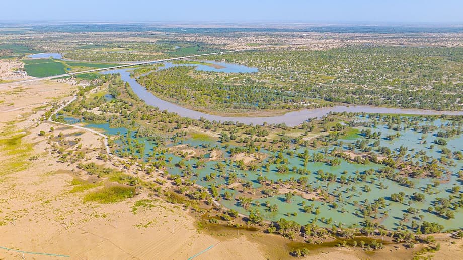
The primary constraint preventing further expansion into the desert interior is water. Current shrublands survive only because of mountain runoff flowing down from surrounding highlands, carrying both moisture and nutrients to the planted belts. Moving deeper into the desert would require reliable water sources that are increasingly scarce across the planet. This dependency on mountain runoff creates vulnerability, as changes to snowfall patterns or glacier melt caused by climate change could potentially weaken or destroy the carbon sink. The vegetation forms a living barrier that literally hangs in the balance between desert extremes and highland water sources.
A Model for Arid Regions
The Taklamakan project stands as a rare, extended case study of desert greening that has endured where others have failed. Political continuity allowed China to maintain consistent funding and labor allocation over four decades, creating conditions for ecological recovery that shorter-term projects cannot achieve. Yuk L. Yung, professor of planetary science at Caltech and senior research scientist at NASA’s Jet Propulsion Laboratory who helped write the study, reflected on the broader implications.
“We found, for the first time, that human-led intervention can effectively enhance carbon sequestration in even the most extreme arid landscapes, demonstrating the potential to transform a desert into a carbon sink and halt desertification.”
The research underscores that deserts are not ecological dead zones but rather potential participants in global carbon management strategies. As wildfires increasingly turn forests from carbon sinks into carbon sources across Europe, Latin America, and North America, the Taklamakan’s transformation offers a counter-narrative about human capacity for environmental restoration. While challenges regarding water security and scale remain significant, the project proves that natural solutions can function effectively even in the planet’s harshest environments. The green belt around the Taklamakan serves as both inspiration and proof of concept for low-tech carbon solutions that require time, stability, and ecological understanding rather than advanced technology.
The Essentials
- China’s Three-North Shelterbelt Program, launched in 1978, has planted over 66 billion trees around the Taklamakan Desert, completing a vegetative encirclement in 2024.
- Satellite data confirms the desert’s periphery now acts as a carbon sink, absorbing more CO2 than it releases, with atmospheric concentrations dropping 1-3 ppm during wet seasons.
- Hardy shrubs and vegetation capture carbon through photosynthesis, representing a more stable storage mechanism than previous sand-based carbon trapping.
- The project depends entirely on mountain runoff for water, limiting expansion potential and creating vulnerability to climate-induced changes in snowmelt patterns.
- Even full afforestation of the desert would capture only 60 million tons of CO2 annually, a modest contribution compared to global emissions of 40 billion tons, but serves as a proof of concept for arid region restoration.