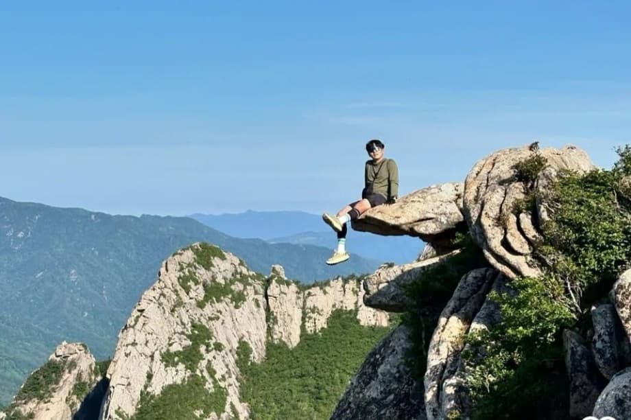
Why a forbidden cliff went viral
Seoraksan National Park in northeastern South Korea is asking hikers and influencers to delete social media posts that showcase a spectacular but banned cliff on a 1,275 meter peak. The rocky perch, set along the park’s serrated Gongnyong Ridge, has drawn a surge of visitors chasing dramatic photos. A recent run of injuries and a fatal fall renewed concern about trespassing into the restricted zone.
The hashtag for the location has collected more than 1,000 posts as of late October. Many images are proof that people left marked paths to reach the exposed outcrop. The park office says the area is not a legal trail, there are no safety rails or anchors, and rescue access is difficult. Officials say the push to remove posts is meant to reduce encouragement for risky copycat trips and to reinforce the rules that keep visitors and wildlife safe.
Under the Natural Parks Act, the peak and the approach are closed to the public to protect fragile habitats and to prevent accidents. Violators can face fines of up to 500,000 won (about 360 dollars). The park also plans more warning signs and extra patrols near popular approach points.
Mountain parks across the country have seen rising social media driven foot traffic in recent years. While most hikers stay on established routes, a small share seeks out off trail places that look dramatic on camera. Misleading captions and geotags can make a risky scramble look like a simple stroll. Rangers say the 1,275 meter spot is exactly the kind of place that feels deceivingly close yet can turn deadly.
The appeal is understandable. The view is rare, the cliff looks pristine, and the image stands out in crowded feeds. The park is not trying to suppress photography. It is asking visitors to respect closures that were written to keep people alive and to leave protected corners of the mountain undisturbed.
Where is this peak and why it is off limits
Seoraksan sits in Gangwon Province on the east coast. It is South Korea’s third highest mountain. The best known summit is Daecheongbong at 1,708 meters. The 1,275 meter feature is not a named summit on official maps. It rises from a narrow ridge of pale granite shaped by wind, frost, and erosion. The ridge gives long views over cliffs and valleys that make the area famous.
Park authorities restrict some ridgelines and gullies to keep soil intact, to protect rare plants and animals, and to limit rockfall. The rules are clear at entry gates and on maps. Rope lines and signboards mark conservation zones. The 1,275 meter spur falls inside one of these zones. There is no maintained trail to it, and the final steps require scrambling over lichen slick blocks that can crumble in wet weather.
Gongnyong Ridge and the allure of exposure
Gongnyong Ridge is often called Dinosaur Ridge for its serrated profile. Sections of it are legal to traverse when open, and those sections are clearly marked and equipped where needed. The banned spur that leads to the cliff leaves that marked route. Photos from the edge exaggerate the drop and give the illusion of floating above the ravine. That visual punch explains why the location spread fast across feeds.
Accidents and warnings mount
The danger is real. In September, a man in his 60s went missing near the area and was later found dead. In separate incidents in 2024, a man in his 30s and a woman in her 60s fell and needed hospital care. Granite can be glassy after rain or frost. Loose gravel can act like ball bearings on steep slabs. Rescue teams must move slowly on the ridge, which extends response times.
Responding to the trend, the Seoraksan National Park office posted a warning on its official Instagram account and asked people to remove content from the cliff and the approach. The office stressed that the site is closed and that social media clout is not worth a life. The agency’s statement spelled out the main risks and the request to take down posts.
Seoraksan National Park office: ‘The 1,275 meter peak is a restricted area, not a place for chasing likes on social media. The rocks are slippery, and the steep slopes pose a high risk of falls and rock slides. We ask that all posts, including photos and videos related to the 1,275 meter summit, be deleted.’
Park staff say they will increase patrols at entry points that lead to the ridge and will install more visual reminders that the trail is not authorized. The goal is to stop people before they leave the main path and to remove any false perception that the location is approved.
What the law says and how enforcement works
South Korea’s Natural Parks Act sets rules for access, camping, and conservation in national parks. The law empowers park managers to designate restricted zones and to penalize entry with administrative fines. In practice, rangers rely on signs, seasonal closures, and public outreach. Police and rescue services support enforcement when an incident occurs.
The maximum fine for entering a protected zone at Seoraksan is 500,000 won. Repeat or aggravated violations can bring heavier scrutiny, especially if a rescue places responders at risk or if damage to protected plants or nesting sites is documented. Those outcomes are rare compared with the daily volume of legal visitors. The current aim is prevention.
Can a post get you fined
Photos and videos can serve as evidence if they show a person in a restricted zone in a way that confirms identity and location. The park’s call to delete content is primarily about removing the spotlight from a dangerous place. Fewer posts reduce pressure on newcomers to chase the same shot. Removing geotags or captions that point to the exact spot also cuts the lure.
The social media effect
Algorithms reward novelty and spectacle. A cliff edge view, a narrow ridge walk, a no rail ledge, these images often surge across feeds. The problem is that a casual onlooker does not see the approach, the wind, the slick rock, or the route finding. Warnings in captions are easy to skip. The cycle can convert a once obscure outcrop into a crowded hazard.
What creators can do responsibly
Creators who love the mountains can help by modeling safe behavior. Do not post from illegal or closed areas. Avoid precise geotags for sensitive locations. Provide honest context about waiting for dry conditions and using legal paths. Highlight ranger guidance and remind viewers that skill, proper footwear, and judgment matter. If a past post shows an illegal visit, consider deleting it or replacing it with a safety message.
Safer ways to experience Seoraksan
Seoraksan offers plenty of legal routes that deliver a sense of drama without breaking rules. The ascent to Daecheongbong, the main summit at 1,708 meters, is a long and rewarding day. The route from Osaek is steep and requires an early start, yet it is marked, maintained, and staffed. On clear mornings the sunrise can be spectacular. Valley paths around well known viewpoints give close looks at granite walls and autumn colors.
Gongnyong Ridge itself has legal traverses when open. These sections are demanding and require fitness, caution, and sometimes the use of fixed chains. Hikers should check for seasonal closures and weather advisories before setting out. Gloves, trekking poles for descents, and shoes with good grip help on wet slabs. Novices can start with shorter trails from the main entrance before attempting full ridge routes.
Preparation and trail etiquette
Plan with the park, not against it. Check the Korea National Park Service website or a visitor center for current closures, shelter status, and trail conditions. Carry layers for wind and cold near the summit. Stay on marked paths. Pack out all trash. Keep noise down near wildlife. If weather turns or the route feels above your skill, turn around. A safe retreat is part of good mountain sense.
What visitors should do now
If you visited the 1,275 meter cliff, do not return. Consider deleting or archiving any post that shows the site or the approach. Remove the geotag if you choose to keep a shot taken from legal ground nearby. Share the park’s message with friends who hike in Seoraksan. When you plan a trip, read the signs at the gate and stick to the routes marked on official maps. Report damaged signage to rangers so closures stay clear to the next group.
At a Glance
- Park urges deletion of posts that showcase a banned 1,275 meter cliff on Seoraksan’s Gongnyong Ridge
- The site is off limits under the Natural Parks Act, with no maintained trail or safety gear
- More than 1,000 Instagram posts used the hashtag by October 20
- Recent incidents include a fatality in September and two injuries in 2024
- Violators face fines up to 500,000 won (about 360 dollars)
- Rangers will add signs and patrols to block access
- Legal alternatives include marked routes to Daecheongbong and open sections of the ridge when conditions allow
- Deleting posts and avoiding geotags can reduce copycat visits