Why Seoul is built for autumn hikes
Few capitals make it as easy to step from a subway platform into a forest ablaze with color as Seoul. Granite peaks rise amid neighborhoods and office towers, and trailheads often sit a short walk from station exits. When the first cold snap arrives, the city’s hills glow with maples, oaks and ginkgo trees in red, tangerine and gold. Locals pull on trail shoes before breakfast, visitors blend in by late morning, and by afternoon the ridgelines fill with tripods and hikers sharing thermoses of hot tea.
- Why Seoul is built for autumn hikes
- When to go and how to plan your route
- Mount Soyo in Dongducheon (Line 1 Soyosan Station)
- Mount Dobong in northern Seoul (Line 1 or 7 Dobongsan Station)
- Mount Yongmun in Yangpyeong (Jungang Line Yongmun Station plus a short bus)
- Namsan in the city center (Line 3 or 4 Chungmuro Station)
- Mount Geomdan in Hanam (Line 5 Hanam Geomdansan Station)
- Mount Gwanak across southern Seoul (Line 2 or 4 access via Sinlim, Seoul National University or Sadang)
- Mount Cheonggye on the southern edge (Shinbundang Line Cheonggyesan Station)
- Mount Namhan and Namhansanseong Fortress (Line 8 Sanseong Station plus a bus)
- Bukhansan National Park, the city’s backyard (multiple subway entries)
- How to prepare and hike safely
- What to Know
Autumn timing has shifted in recent years, with peak color around the capital often drifting later. In Seoul, bright foliage typically arrives from late October to early or mid November. Elevation and exposure matter too. Higher ridges and shaded valleys peak first, lowland paths and palace gardens hold color longer. With a T money card and a plan, you can catch it all without renting a car. The routes below focus on mountains in or near Seoul where trailheads connect directly to subway stations, plus practical advice on timing, safety and the best post hike meals nearby.
When to go and how to plan your route
Late October through the first half of November is the sweet spot for most of the capital region. Mountain microclimates vary. West facing slopes may turn later than north facing gullies, and a single storm can strip exposed maples while sheltered ravines stay vivid. Check a local forecast the day before you go, then zoom in on recent photos from the same mountain on navigation apps. Aim for weekday mornings if possible, and arrive early on weekends. Lines can form at popular bottlenecks near temples and summits, especially at Namsan, Dobongsan and Namhansanseong.
Transit planning is straightforward. Every destination below lists the closest station and, when needed, a short bus ride from the station exit to the park entrance. Subway signage and station exits are clear in English and Korean. Load or top up a T money card, then use Naver Map or Kakao Map to find the trailhead from the exit. For longer climbs like Yongmunsan, confirm the return bus schedule before you start. Pack layers. Autumn mornings can feel sharp at the start and warm by midday. Grippy shoes, water, a snack and a charged phone are essential. Sunset comes earlier in the mountains than in the city streets, so carry a small light if you expect a late finish, and keep an eye on the last train time for your line.
Mount Soyo in Dongducheon (Line 1 Soyosan Station)
Step off at Soyosan Station and you are five minutes from the foot of Mount Soyo, a peak recognized among Korea’s 100 celebrated mountains. Trails fan out from a support center into gentle valley paths and steeper ridges. Beginners can follow the lower course to Jajaeam Temple and Seonyeotang near Wonhyo Daesa Rock, a relaxing route that still delivers sweeping bands of scarlet and amber. Stronger hikers can push to Gongjubong or Uisangdae for big views. Trail signage is consistent, so watch for forks that lead to the foliage highlights if you prefer a shorter day.
Mount Soyo even has a long running foliage celebration. On Oct. 26 the Soyo Mountain Autumn Foliage Festival returns to the outdoor stage with performances and hands on activities. After your loop, warm up with Dongducheon’s classic budaejjigae near the station. The spicy broth, sausage and kimchi hit the spot after a brisk descent.
Mount Dobong in northern Seoul (Line 1 or 7 Dobongsan Station)
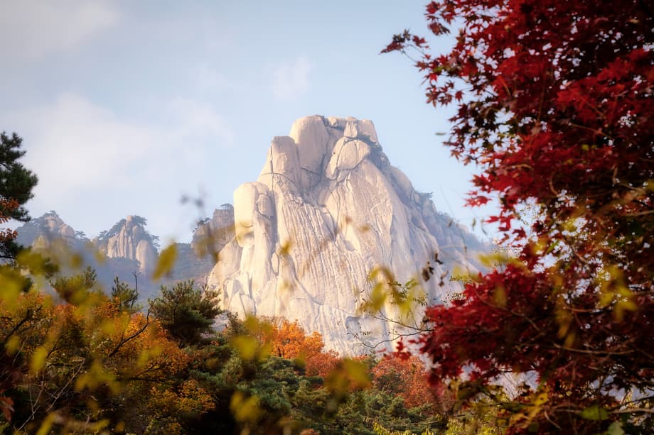
Dobongsan rewards those who like a little granite underfoot. The climb past Manwolam Temple is a study in gold and crimson, and on quiet mornings a monk sometimes shares tea with hikers. From the temple, photo spots stretch to Podae Ridge, where a bird’s eye view looks out over a sea of color flowing down the slopes. Continue to Jaunbong for one of the broadest outlooks in the park. Trails grow rockier and more technical near the top, so allow time for scrambles and light traffic at pinch points.
Back at the base, Sanarae Joomak near the support center draws hungry hikers with spicy mackerel stew and charcoal grilled bulgogi, served with a spread of side dishes that can turn lunch into an occasion.
Mount Yongmun in Yangpyeong (Jungang Line Yongmun Station plus a short bus)
Few places say autumn like a corridor of golden ginkgo leaves, and Yongmunsan is famous for exactly that. From the station, a short bus ride brings you to the entrance and the Yongmunsan Tourism Complex, where tree lined paths and gardens offer easy photo spots even before the hike begins. A 15 minute walk leads to Yongmunsa Temple and its legendary ginkgo, estimated at about 1,100 years old. The tree stands roughly 42 meters tall, with a trunk that measures about 15 meters around, and is believed to be the largest ginkgo in Asia.
For a workout, take the trail from the temple toward the upper ridges. The shortest route to the peak takes three to four hours, with longer options closer to five. Sound carries in these valleys in autumn, so you hear water and wind as much as conversation. Vendors near the entrance sell snacks like gangjeong for quick fuel. If you stay for a meal, the local favorite Yongmunsan Sikdang serves grilled deodeok and bibimbap, best enjoyed on the terrace with crisp mountain air.
Namsan in the city center (Line 3 or 4 Chungmuro Station)
Namsan is the uncomplicated autumn crowd pleaser that even first time visitors can enjoy in an hour. From Chungmuro Station, enter via Namsangol Hanok Village and follow signs for the northern section of the dulle trail. The paved North Circular Road, often called the “Foliage Road,” wraps you in color without a steep grade. Continue uphill to reach Namsan Observatory for a city panorama framed by rusting leaves. If you prefer a bigger climb, the Myeongdong Stairs route offers an energetic 1.2 kilometer incline with skyline views, while the Seoul City Wall Trail contours along 14th century stones with long looks toward Bukchon Hanok Village. You can also ride a shuttle bus or the cable car to save your legs for the descent.
Travel blogger Audrey, who documented an autumn climb to Namsan, captured the feel of the season at the peak of color.
Autumn in Seoul is a spectacular time to explore outdoors, especially at Namsan. The climb is not daunting at 262 meters, but there are hundreds of steps, and the trees are at their most colorful from late October to early November. The observatory deck offers 360 degree views, especially beautiful at dusk.
For dinner near the base, Namsan Heukso is known for top quality hanwoo beef, a classic way to end a short city hike.
Mount Geomdan in Hanam (Line 5 Hanam Geomdansan Station)
Geomdansan sits above the Han River with a mix of easy grades and short steeps, ideal for newer hikers or families. From Exit 3, trails are well marked and the summit is about 90 minutes away. There are five main routes, each with its own rhythm and vantage points. The course from Hanam Memorial Tower to Hoguksa Temple is especially popular for its long lines of color and gentle slope, though the final meters near the 657 meter peak feel steeper. On a clear day the river shimmers below and the ridges to the east roll toward the horizon.
Afterward, spicy handmade sujaebi near the station is a hearty choice. It is the perfect bowl for practicing iyeolchiyeol, the local idea of meeting the chill with heat.
Mount Gwanak across southern Seoul (Line 2 or 4 access via Sinlim, Seoul National University or Sadang)
Gwanaksan is the south side classic, reachable from several stations. From Gwanaksan Station, follow signs for the Autumn Foliage Road into the park. From Sadang Station, use Exit 4 to reach a popular approach, and from Seoul National University Station take Exit 3 then transfer to a short bus ride for a direct start. The shared goal for many is Yeonjudae, a dramatic viewpoint that looks out over a patchwork of reds and golds with the city sprawling beyond.
If you begin at the Seoul National University entrance, expect about an hour to the top on a straightforward path. Massive slabs beside the trail make easy photo spots, and on clear days a temple appears in the foreground with the skyline behind. Back near the base, Deungmaru by Bongcheon Station is a long standing stop for pajeon and bowls of makgeolli, a pairing many Korean hikers count as part of the ritual.
Mount Cheonggye on the southern edge (Shinbundang Line Cheonggyesan Station)
Cheonggyesan straddles Seoul’s border with Gwacheon, Seongnam and Uiwang, and its proximity, flexible distances and good signage make it one of the most accessible fall walks. From Cheonggyesan Station Exit 2 the trail network starts quickly. There are five main hiking courses ranging from about one hour to just over two hours. Expect long staircase sections on the most direct routes. If you prefer less climbing, a custom loop to Wonteogol, Gilmajae and Maebong gives steady elevation and frequent views.
Many leaf seekers stop at Maebong Rock instead of the summit. It is a photogenic perch with Lotte World Tower poking above a rolling canopy. Another favorite is Ggaldakgogae, a tree lined lane that glows at midmorning. When you finish, Cheonggyesan Gondrejib near the station serves gondeurebap, rice steamed with mountain herbs, with charcoal grilled bulgogi on the side.
Mount Namhan and Namhansanseong Fortress (Line 8 Sanseong Station plus a bus)
Namhansanseong is both a mountain park and a historic fortress, designated as a UNESCO World Heritage site. Trails wind along stone ramparts and through groves that blaze yellow and crimson in late October. Most first time visitors choose Courses 1 or 2, both roughly one hour loops that trace sections of the fortress walls. Course 1 begins at the North Gate, a site once used to launch a surprise attack during the Manchu invasion. Along the way you pass Jihwa Gate, Jeonseung Gate and Jwaik Gate, each framed by brilliant foliage when the season peaks.
Near Sueojangdae Pavilion, the last remaining command post of five that once stood here, towering trees shed golden leaves that pile up on the paths. The Namhansanseong Haenggung, a temporary palace used during wartime, sits nearby and is worth a detour. For a warm meal before heading back, Obok Sundubu near the main entrance serves tofu stew with mushrooms and soft curds that hit like a hug after a cool day outside.
Bukhansan National Park, the city’s backyard (multiple subway entries)
Seoul’s only national park stretches across the northern skyline, famous for granite domes, rushing streams and a tree mix that makes for a long, photogenic fall season. There are many entrances. Bukhansan Ui Station on the Ui Sinseol Line sits near the Uiryeong trailhead, though the Uiryeong route operates on a reservation system with daily visitor caps to protect a pristine ecosystem. The main trail network also connects from stations like Gupabal, where a quiet path leads to Guknyeong Temple and its 24 meter seated Golden Buddha, surrounded by rows of small golden statues.
Trails in Bukhansan are steeper and rockier than many newcomers expect. A member of a Seoul travel community who hiked from the Jeongneung entrance this time last year advised bringing proper footwear and trekking poles.
It was supposed to be a level 2 trail, but there were lots of rock stairs up and rocky terrain down. Sometimes we had to scramble. We saw many Korean seniors in snappy hiking gear navigating like it was their backyard. The foliage and the views were spectacular.
Another pair of hikers who explored less traveled routes into Sapaesan and Angol Valley described a summit that required ropes and a descent wrapped in vivid leaves.
The trail was steep and rocky, with boulders to climb and ropes to help at the summit. The views from the top were expansive, and the descent into Angol Valley was filled with vibrant autumn leaves.
If you want an easy option without reservations on the north side, consider the Obong viewpoint reached from the Uiryeong area. It offers big scenery without committing to a full summit. Bring snacks, carry your trash out, and give yourself time. Bukhansan is beautiful, and it rewards patient pacing.
How to prepare and hike safely
Layer smart. A base layer, light insulated layer and a wind shell cover most days. Gloves make metal railings and cold rocks more comfortable. Shoes with tread matter on leaf covered stone, and simple hiking poles reduce strain on long stair sections. Pack one and a half liters of water for half day hikes, a snack with salt, and a small light in case your return runs late.
Respect the trail culture. Stay to the right on staircases, yield to climbers on narrow rock sections, and keep voices low near temples. Smoking is banned in parks. Carry out all trash. At photo bottlenecks, step aside after your shots so others can pass. If you plan a lesser known route, download an offline map segment on your phone. If you are hiking solo, share your plan with a friend or your hotel. For emergencies, dial 119. Rangers and rescue teams coordinate quickly in the Seoul area.
Check reservations if you aim for the Uiryeong trail in Bukhansan. For busy destinations like Namsan or Namhansanseong, start early to avoid lines at gates and cable cars. Keep an eye on last train times for your line and leave a buffer. If you want a short plan B on the east side, Yongmasan and neighboring Achasan (Line 7) offer easy ridge walks with sunrise views and reliable fall color.
What to Know
- Peak foliage around Seoul generally runs from late October to early or mid November, with higher ridges turning first and palace gardens holding color longer.
- Soyo (Line 1 Soyosan Station) is five minutes from the trailhead, with easy valley walks and tougher ridges to Gongjubong or Uisangdae; a foliage festival takes place on Oct. 26.
- Dobongsan (Line 1 or 7 Dobongsan Station) offers temple scenery, granite scrambles and a panoramic view from Jaunbong; expect rockier terrain near the top.
- Yongmunsan (Jungang Line to Yongmun Station plus a short bus) features the 1,100 year old ginkgo at Yongmunsa Temple and longer summit routes of three to five hours.
- Namsan (Line 3 or 4 Chungmuro Station) has a paved “Foliage Road” and an hour long stroll to the observatory, with options to ride a shuttle bus or cable car.
- Geomdansan (Line 5 Hanam Geomdansan Station) has five easy to moderate courses and views of the Han River; the Hanam Memorial Tower to Hoguksa route is a favorite.
- Gwanaksan (access via Sinlim, Seoul National University or Sadang on Lines 2 or 4) leads to Yeonjudae for city and foliage views, with classic post hike pajeon and makgeolli nearby.
- Cheonggyesan (Shinbundang Line Cheonggyesan Station) offers one to two hour loops, many stair sections, and photogenic stops like Maebong Rock and Ggaldakgogae.
- Namhansanseong (Line 8 Sanseong Station plus a bus) is a UNESCO site with one hour loops along fortress walls, historic gates and the Sueojangdae Pavilion.
- Bukhansan National Park has multiple subway entries; the Uiryeong route uses a reservation system with daily caps, and rocky sections require good shoes and care.
- Bring layers, water, grippy footwear and a light; check weather, start early on weekends, and dial 119 in an emergency.
- Local eats near trailheads include budaejjigae in Dongducheon, bulgogi and mackerel stew at Dobongsan, grilled deodeok at Yongmunsan, hanwoo near Namsan, sujaebi at Geomdansan, and tofu stew at Namhansanseong.