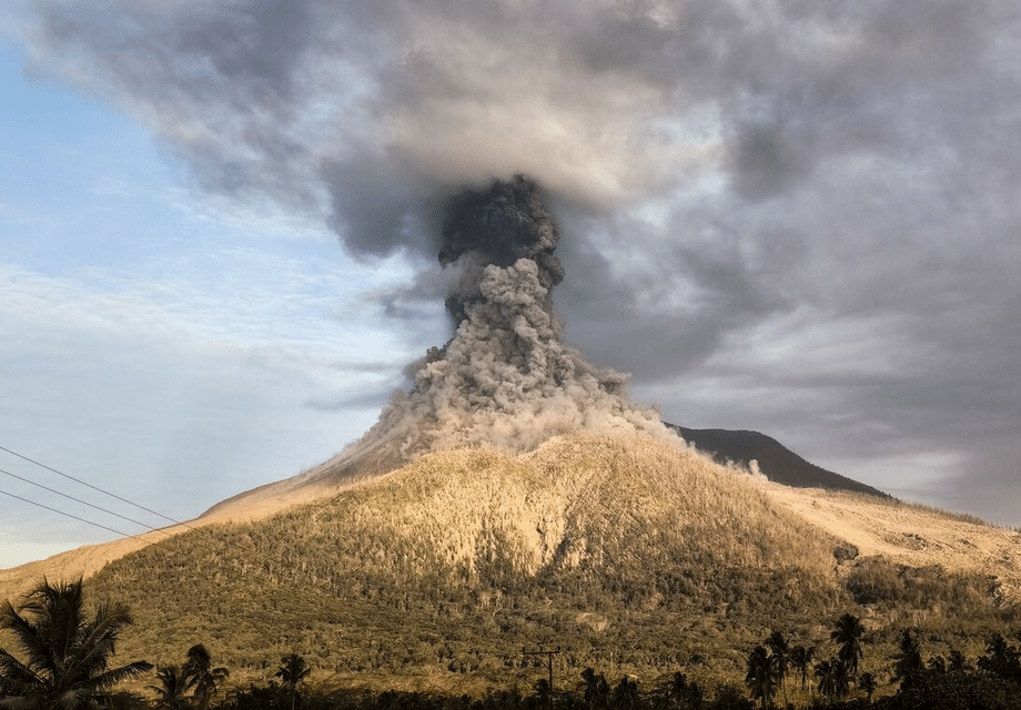
Eruptions intensify on Flores as authorities enforce top alert
Mount Lewotobi Laki-Laki on the Indonesian island of Flores has burst into a new phase of activity, with a string of eruptions that pushed ash high into the sky and forced the suspension of flights at the local airport in Maumere. Indonesia’s Geological Agency raised the alert to the highest level late on Friday night (Sep 19), signaling a serious escalation and ordering people to keep a wide berth around the volcano. The most powerful burst during the evening sent an ash column about 6 kilometers above the peak, followed by several more eruptions on Saturday morning, including one reaching roughly 2.5 kilometers. Officials warned of hazards to aviation and urged residents living near river valleys to watch for fast moving volcanic floods if rain arrives.
- Eruptions intensify on Flores as authorities enforce top alert
- What changed on the night of September 19
- Impact on air travel and local closures
- Hazard map and safety guidance for communities
- How this eruption fits into a longer cycle
- What the instruments are saying
- What residents are facing right now
- Tourism and logistics on Flores
- How ash clouds affect aircraft
- Why the sectoral exclusion zone matters
- At the center of a long running eruption cycle
- Key Points
The Lewotobi volcanic complex consists of two adjacent peaks, Laki-Laki and Perempuan, with summits separated by less than 2 kilometers. Laki-Laki rises to about 1,584 meters and is the more active of the pair. The current sequence began on Friday evening and continued into Saturday, according to monitoring data collected at the site and by the national volcanology center. Airports on Bali remained open and reported normal operations, yet the new ash plumes created fresh uncertainty for regional air travel, especially around Flores island and nearby routes.
Authorities set a broad exclusion zone of at least 6 kilometers from the crater, expanding to 7 kilometers along a southwest to northeast sector where dangerous flows or ballistic ejecta could travel. Communities near channels that drain the volcano were cautioned about lahars, a type of fast moving slurry of ash, rock, and water that can surge down streams during heavy rain. These flows can move with little warning and are often as destructive as the eruption itself.
What changed on the night of September 19
Instrument networks tracking the volcano recorded a clear uptick on Friday. The volcanology agency documented a sequence of at least a dozen explosive events beginning in the afternoon. Activity intensified into the night, with one of the tallest plumes reaching around 6,000 meters above the vent at about 10:46 p.m. local time. On Saturday morning, fresh explosions produced additional ash emissions, including one plume that climbed roughly 2.5 kilometers into the sky.
The decision to raise the alert level reflected not only the tall ash columns but also the pattern of seismic signals and deformation measured in recent days. A sectoral safety zone was added on the western and northeastern flanks, where past deposits and topography can channel hot flows and dense ash clouds. Officials stressed that any heavy rainfall could mobilize fresh volcanic material into rivers, turning ash and debris into high energy mudflows that threaten bridges, roads, and villages downstream.
Impact on air travel and local closures
Frans Seda Airport in Maumere suspended operations after the Friday night eruptions, a precaution that reflects how easily volcanic ash can damage aircraft engines and affect visibility. Flight planners watch cloud height, density, and wind direction because ash can drift far from the source and linger at cruising altitudes. Jets can ingest the gritty particles into engines, which may erode turbine blades, clog sensors, and in worst cases cause flameouts. Ground crews also contend with ash accumulation on runways and ramp equipment, which complicates operations even under otherwise clear conditions.
Airport officials in Maumere said they would reassess the situation after a period of monitoring. The head of the airport, Partahian Panjaitan, explained that any reopening would depend on what the volcano does over the next day.
He stated the plan directly.
“We will monitor developments before deciding whether to reopen.”
Bali’s main airport, a key hub for international tourism, reported normal operations on Saturday. That status can change quickly if winds shift or if the volcano produces a much taller and denser cloud. The region has already seen how disruptive Lewotobi can be for aviation. On July 7, 2025, Laki-Laki blasted ash to about 18 kilometers, and airports across the region canceled dozens of flights. Satellite instruments later mapped the cloud drifting across the archipelago.
Hazard map and safety guidance for communities
The Geological Agency kept the highest alert level in place and reinforced clear instructions for anyone living or traveling near Lewotobi Laki-Laki. The basic rule is to stay at least 6 kilometers from the crater, with a 7 kilometer sectoral buffer on the southwest to northeast axis. That pattern mirrors historical channels where hot currents or thick ash clouds might move if the volcano produces stronger explosions. The agency also urged vigilance near rivers that rise on the volcano, since rainfall can trigger lahars that carry boulders, logs, and a heavy mix of ash and water.
Agency chief Muhammad Wafid outlined the risks in plain terms, focusing on personal safety and the knock-on effects for air travel.
“Residents and tourists should stay at least 6 kilometers from the crater. Volcanic ash can disrupt airport operations and flight paths.”
Ashfall can contaminate water sources and coat roofs with a heavy load that becomes especially risky when wet. Local officials advise using masks or cloth to cover the nose and mouth during ashfall, sweeping roofs gently to avoid collapse, and keeping gutters and drains clear. People with respiratory conditions should limit outdoor exposure when ash is in the air. Drivers should slow down on ash covered roads because stopping distances increase on the powdery surface.
How this eruption fits into a longer cycle
Lewotobi Laki-Laki has been busy since late 2023, moving between quiet spells and active phases. An especially intense period in November 2024 produced explosive events that turned deadly and coated wide areas with ash. The volcano erupted again at points in early 2025, including a period in March, and then entered another vigorous phase in mid year. On June 17, authorities set the highest alert level after tall ash emissions and unrest. On July 7, the volcano generated an ash cloud that soared roughly 18 kilometers into the upper troposphere and lower stratosphere. That event produced pyroclastic flows that ran up to 5 kilometers down the flanks, and villages reported heavy ashfall.
NASA’s Earth Observatory later published satellite imagery that captured the July plume and the direction of its drift. The agency noted that monitoring data had shown increased earthquake activity and inflation of the ground surface ahead of that eruption, a pattern that suggests magma moving upward and pressurizing the system. The broader history of the complex shows a clear difference between its twin peaks. Laki-Laki has produced frequent eruptions since the 19th century, while Perempuan is taller but far calmer, with confirmed eruptions recorded in 1921 and 1935.
What the instruments are saying
Volcanologists track Lewotobi with seismometers that listen for small volcanic earthquakes, tiltmeters that measure minute changes in slope, and GNSS stations that detect ground motion across longer distances. Prior to the latest escalation, networks had recorded periods of continuous tremor, clusters of low frequency quakes, and signs of shallow inflation. All of these signals align with magma and gas moving through the conduit. At times, technicians observed steady white emissions from the summit, a sign of degassing. When the conduit becomes obstructed, pressure can build toward an explosive release, which is why sudden ash columns can appear even after a seemingly quiet interval.
Remote sensing complements the ground work. Instruments on polar orbiting satellites, including VIIRS (Visible Infrared Imaging Radiometer Suite), can detect hot spots and map ash clouds that are invisible to the naked eye at night. That data helps aviation forecasters estimate where ash is moving. It also assists local authorities in focusing inspections on downwind villages and road corridors that might need cleanup or aid. The combination of field observations, seismic and deformation data, and satellite imagery forms a layered picture of the volcano’s state.
What residents are facing right now
People living within sight of Lewotobi reported ash settling on homes and crops after the Friday and Saturday eruptions. Ashfall can irritate eyes and lungs, abrade painted surfaces, and damage electronics if it infiltrates equipment. Farmers often need to rinse leaves and clear irrigation tracks. Villages on the flanks that saw thick ash in previous episodes still work through periodic cleanup, especially on rooftops. Emergency officials urged communities to avoid riverbanks during storms and to plan alternative routes in case lahars block roads or damage bridges.
Local disaster agencies said there were no immediate reports of casualties from the latest events. Evacuations in earlier phases moved the most exposed households away from danger zones near the crater rim and known flow channels. If eruptions intensify again, authorities could widen the exclusion radius or designate new sectoral zones, a step that helps steer people away from the most likely paths of hot debris and ash clouds.
Tourism and logistics on Flores
Flores draws visitors for its reefs, islands, and volcanic scenery, but the new activity has complicated travel plans. With Maumere’s airport temporarily closed, passengers faced delays or rerouting, and airlines advised travelers to check the status of flights near Flores and in the wider region. Bali’s airport, the busiest international gateway in Indonesia’s east, stayed open on Saturday, and operators said conditions did not warrant diversions.
A spokesperson at Bali’s airport described the status plainly.
“Operations are normal at Bali’s airport,” said Gede Eka Sandi Asmadi, noting there were no disruptions on Saturday.
Climbing routes around Lewotobi are off limits while the alert stays at the top level. Local authorities also discouraged sightseeing near the volcano, since wind direction can shift and fresh ash bursts can arrive with little warning. Travelers should follow directions from the regional disaster management agency and consult official channels before attempting overland trips that pass river valleys draining the volcano.
How ash clouds affect aircraft
Volcanic ash is not like smoke or steam. It is made of tiny jagged particles of rock and glass formed when magma shatters as gases decompress. When a jet flies through a thick plume, the particles can sandblast cockpit windows, clog pitot tubes that measure airspeed, and melt inside the hot section of the engine. The molten material can then resolidify on turbine blades and vanes, leading to power loss. Even a thin haze can trigger extra wear and tear on engines and sensors. For this reason, pilots avoid known ash and aviation meteorologists rely on rapid satellite detection and pilot reports to draw no fly advisories.
Indonesia sits atop the tectonic arcs of the Pacific Ring of Fire, which host more than 120 active volcanoes across the country. Air routes in Southeast Asia often thread between these peaks and their downwind sectors. That geography means airlines and air traffic controllers must act quickly when a volcano grows restless, shifting routes, changing altitudes, or canceling flights when safety margins shrink.
Why the sectoral exclusion zone matters
A standard circular safety radius around a volcano is only a starting point. Scientists tailor hazard maps to the shape of the cone, the breach direction of its craters, and the paths carved by previous flows. At Lewotobi, both summit craters are breached to the north, and the local topography channels currents along specific flanks. The expanded zone from the southwest to the northeast reflects those pathways. Pyroclastic density currents, which are fast and extremely hot, ride along valleys and can outrun people on foot. Even when the volcano is quiet, heavy rains can mix loose ash and rock into lahars that batter the same channels for months after an eruption.
Officials have asked local governments to coordinate closely with the volcano observation post and the national mitigation center. That coordination includes watching rainfall totals, checking bridges and culverts after storms, and staging supplies for ash cleanup. Residents downwind are encouraged to keep simple masks at home, store clean water, and secure livestock during ashfall. If ash begins to fall, closing windows and placing damp cloth at door gaps can help keep the air clearer indoors.
At the center of a long running eruption cycle
All signs point to a restless system that can produce rapid changes. Eruptions have come in pulses since late 2023, and the volcano has moved between high alert and slightly lower settings as activity waxed and waned. The latest step up, with vigorous explosions and taller columns, has renewed concern about effects on air travel and on communities close to the cone. Scientists will watch for new lava at the crater and any signs of flow activity on the flanks, since either would indicate continued magma supply at shallow depth. If activity declines, the alert could be lowered, yet the ash and debris on the slopes will keep lahar risk elevated during storms.
Satellite observations will continue to play a role in tracking the plume and pinpointing ash transport. NASA’s Earth Observatory provides periodic updates and imagery that help illustrate changes in the plume’s height and direction on its public site. Combined with ground based measurements, those tools give forecasters and local leaders a clearer view during a fast moving crisis.
Key Points
- Lewotobi Laki-Laki on Flores produced multiple eruptions from Friday night into Saturday, with the tallest ash plume rising about 6 kilometers above the peak.
- Indonesia’s Geological Agency raised the alert to its highest level and set a 6 kilometer exclusion zone, expanding to 7 kilometers along a southwest to northeast sector.
- Frans Seda Airport in Maumere suspended flights, while Bali’s airport reported normal operations on Saturday.
- Authorities warned of lahar risk during heavy rain and urged residents to avoid river valleys that drain the volcano.
- July 7, 2025 saw an 18 kilometer ash column and pyroclastic flows up to 5 kilometers, part of ongoing activity since late 2023.
- Past eruptions at Lewotobi have caused casualties and significant ashfall; the twin volcano Perempuan remains comparatively quiet.
- Satellite instruments and ground sensors track ash and deformation to support aviation safety and local hazard planning.