A major push at South Reef
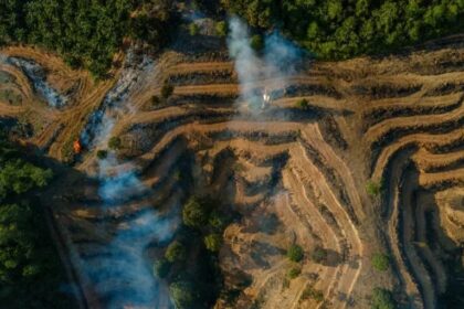
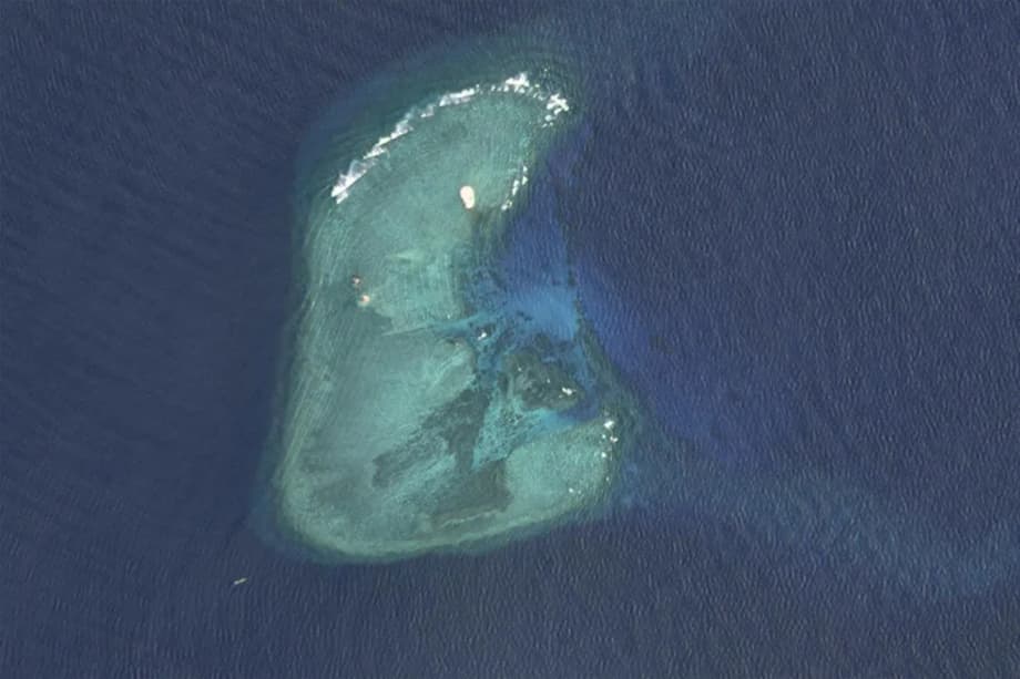
Vietnam has accelerated land reclamation on South Reef in the northern Spratly archipelago, expanding a once submerged low tide elevation into a fortified platform of more than 60 hectares within roughly two years. Known in Vietnamese as Da Nam, the reef sits just a few kilometers from Philippine held Parola Island and less than five kilometers from Vietnam’s own Southwest Cay. Recent satellite imagery shows dredgers, cranes and support vessels working in rotation as new land takes shape and structures rise. The work at South Reef is part of a broader buildout across all Vietnamese held features in the Spratlys.
- A major push at South Reef
- Where is South Reef and why location matters
- How much land is Vietnam adding and where
- What new infrastructure reveals about intent
- China’s response and a shifting center of gravity
- Vietnam, the Philippines and risk management
- Law of the sea, what dredging does not change
- Capabilities and limits of Vietnam’s new footprint
- Environmental price and a tentative green pivot
- What to watch next
- Key Points
Hanoi first occupied South Reef in the late 1980s during what it calls the CQ 88 campaign. For decades the outpost amounted to two small pillbox positions that were usable only at low tide. Reclamation that began in late 2023 has transformed the feature into one of Vietnam’s largest Spratly positions. The reef sits near routes that connect North East Asia to Southeast Asia, Australia and the Pacific, a corridor that carries about one third of global maritime trade. Control of a larger footprint, coupled with nearby Vietnamese outposts, improves sustainment and surveillance in a crowded patch of sea.
Where is South Reef and why location matters
South Reef lies in close proximity to two of the most visible outposts in the northern Spratlys. Southwest Cay, held by Vietnam, hosts a lighthouse, a garrison and communal facilities. Parola Island, held by the Philippines, remains less built up. The Vietnamese position at South Reef is also roughly 50 kilometers north of Subi Reef, which is held by China. That cluster of reefs sits astride key shipping routes and productive fishing grounds.
Distances and chokepoints
In practical terms, the short distances between these features let forces on each side see and respond quickly to any incident. A larger land area at South Reef, paired with nearby harbors and air access at other Vietnamese sites, strengthens internal lines of communication between outposts. That reduces reliance on resupply from the mainland and increases the ability to sustain a presence during periods of tension.
How much land is Vietnam adding and where
Vietnam has expanded all 21 of the features it holds in the Spratly Islands with artificial land since 2021, an expansion drive that extended to eight additional sites at the start of 2025. New dredging and landfill work appeared at Alison, Collins, East, Landsdowne and Petley reefs, while fresh rounds of expansion resumed at Amboyna Cay, Grierson Reef and West Reef. By March 2025, independent assessments estimated Vietnam had created about 70 percent as much artificial land area in the Spratlys as China did during its earlier campaign. A separate analysis put Vietnam’s total new land since late 2021 at more than 8.5 square kilometers. The scale points to an effort that will likely match and could exceed the footprint China generated in the last decade.
South Reef’s growth curve
At South Reef, dredging began in October 2023 and expanded rapidly through 2024 and 2025. Imagery shows continuous construction, with new buildings, berms and roads taking shape on a platform that now spans more than 60 hectares. Structures consistent with barracks and logistics buildings have appeared, along with protected storage that analysts identify as ammunition or munitions depots. Facilities that improve daily life for small garrisons, such as common spaces and recreation rooms, have also been noted, and troops are encouraged to grow vegetables and keep small livestock to supplement supplies.
What new infrastructure reveals about intent
Across multiple Vietnamese held reefs, a recurring pattern of construction is visible. Crews are carving out harbor basins and laying wharves, allowing vessels to moor and offload cargo in rough weather. New storage sites, often six containers surrounded by thick blast walls, appear at each reef. Standardized clusters of six buildings arranged on three sides of a courtyard face outward toward the water, and many reefs feature two such clusters at opposite ends of the landmass. The layout suggests a focus on sustainment, surveillance and close in defense rather than on large offensive operations.
Runway at Barque Canada Reef
One site stands out. At Barque Canada Reef, Vietnam is building a runway of roughly 3.0 to 3.2 kilometers, which will become the country’s second airstrip in the Spratlys alongside the existing strip on Spratly Island. A runway of that length can accommodate transport aircraft, maritime patrol planes and helicopters, supporting troop rotations and medical evacuation as well as patrol flights. Analysts had speculated that other long features, such as Ladd, Pearson, Tennent and South Reef, could also host airstrips. Site layouts seen in recent imagery, with building clusters and storage positioned along the longest stretches of new land, now make full length runways at those features unlikely.
China’s response and a shifting center of gravity
China has objected to Vietnam’s activities but its public response has been relatively muted compared with its confrontations with the Philippines. Beijing has increased patrols near Vietnamese held features while it channels sharper rhetoric and coercive tactics toward Manila in other parts of the South China Sea. Chinese leaders appear to be managing two priorities at once, protecting expansive claims while avoiding a rupture with Hanoi that could drive Vietnam closer to outside partners.
At a routine press briefing, Foreign Ministry spokesperson Guo Jiakun restated Beijing’s position on the Spratlys.
“The Spratly Islands are China’s inherent territory. China firmly opposes relevant countries construction activities on illegally occupied islands and reefs. China will take necessary measures to safeguard its territorial sovereignty and maritime rights and interests.”
Analysts see tactical calculation in the contrast. Collin Koh, a research fellow at the S. Rajaratnam School of International Studies in Singapore, said China has been more focused on direct confrontations with the Philippines.
“For now much of China’s bandwidth of attention is directed at the Philippines, and it would rather maintain a stable front with each of the other Southeast Asian rivals in the South China Sea.”
Ray Powell, who leads the SeaLight maritime transparency project at Stanford University, linked the muted reaction to a strategy of isolating Manila.
“It seems that Beijing has calculated that keeping the Philippines isolated from the other South China Sea claimants is worth more right now than preventing Vietnam from making substantial territorial gains.”
That approach has coincided with a sharp rise in face offs between Chinese and Philippine vessels near Second Thomas Shoal and Scarborough Shoal, including incidents of ramming and high pressure water cannon use that caused injuries. Chinese ships have also sustained damage during tense maneuvers. Those episodes have drawn regional and international attention while work at Vietnamese outposts proceeds with little direct interference.
Vietnam, the Philippines and risk management
Hanoi and Manila balance proximity with practical coordination. The two sides have agreed protocols for managing encounters at sea and have strengthened coast guard cooperation and information sharing. Vietnamese and Philippine troops stationed on neighboring outposts in the northern Spratlys often maintain cordial personal ties, a reflection of the tight quarters where both sides watch each other day to day. Vietnamese expansion at South Reef may rankle in some circles in Manila, yet both governments have incentives to keep friction contained.
Proximity without flashpoints
South Reef sits less than five kilometers from Southwest Cay and about eight kilometers from Parola Island. That geography concentrates activity but does not make confrontation inevitable. Southwest Cay has a lighthouse, barracks and a common hall, while Parola remains comparatively less developed. Regular communication channels and agreed procedures lower the odds that routine interactions escalate into incidents.
Law of the sea, what dredging does not change
Vietnam has not formally expanded its maritime claims with this construction. Under the United Nations Convention on the Law of the Sea, a low tide elevation such as the original South Reef does not generate its own territorial sea or exclusive economic zone. Artificial land created by dredging does not change that status. A 2016 ruling by an international tribunal in The Hague found no legal basis for expansive historic rights claims over most of the South China Sea. Governments can improve their outposts, yet the act of reclamation does not create new entitlements at sea.
Low tide elevations and maritime zones
Under the treaty, islands that can sustain human habitation or an economic life may generate a 200 nautical mile exclusive economic zone. Rocks that cannot sustain such life generate only a 12 nautical mile territorial sea. Low tide elevations generate none on their own. Many features in the Spratlys are small and sit close together, which means overlapping zones even where entitlements exist. Upgrading a reef with sand and concrete does not transform its legal character, and that helps explain why Vietnam emphasizes consolidation and resupply rather than new claims.
Capabilities and limits of Vietnam’s new footprint
The new bases give Vietnam better logistics, longer endurance at sea and more resilient communications among outposts. Harbor basins and wharves let supply ships and patrol craft stay forward for extended periods, which is useful for monitoring fisheries, escorting survey vessels and responding to harassment of oil and gas operations. Larger platforms can host coastal defense weapons, short range rockets and improved radar. The upgrades raise the cost of coercion around individual outposts, even if they do not shift the broader balance against China.
From outposts to a network
Vietnam’s navy and coast guard remain smaller and less modern than Chinese forces, and fleet expansion has slowed. The new infrastructure still offers practical benefits. Standardized building clusters ease construction and maintenance. Additional storage, fuel and power make it easier to rotate personnel and stage equipment. A single new runway at Barque Canada Reef will improve medical evacuation and logistics flows, yet the pattern of construction points to a defensive network built to endure in place rather than to project power over long distances.
Environmental price and a tentative green pivot
Dredging and landfill damage reefs and seagrass beds, stir up sediment and degrade water quality. Artificial islands require constant reinforcement to resist waves and storm surge. Rising seas and stronger storms will keep pressure on low lying platforms, locking in high maintenance costs. The program is popular at home as a demonstration of resolve, yet scientists warn of long term ecological damage and growing climate exposure. Those concerns have prompted discussion in Hanoi about expanding marine protected areas in the East Sea as part of a Marine Strategy to 2030. Such reserves could help sustain fisheries and habitats while also providing a framework for patrols and enforcement.
Climate realities at low lying features
Most reclaimed platforms sit barely above sea level. Storm seasons bring heavy surf that can erode berms and flood lower sections. Maintaining sand based islands often means adding fresh fill, repairing quay walls and extending breakwaters. That cycle is costly and leaves even large outposts vulnerable to extreme weather. Managing that risk will require both engineering and restraint in how these sites are used.
What to watch next
South Reef will remain a barometer for the pace and character of Vietnam’s expansion. Watch for how quickly interior roads, seawalls and quay lengths are completed, and whether additional sheltered moorings appear. Progress at Barque Canada Reef’s runway will influence how Vietnam manages rotations and surveillance across the northern and central Spratlys. China is likely to continue visible patrols near Vietnamese outposts while keeping its sharper confrontations focused on the Philippines. Malaysia has protested runway construction at Barque Canada Reef, and Kuala Lumpur as well as Manila will watch for any moves that complicate their own claims. The contest is likely to proceed in increments, with most movement visible first in commercial satellite imagery before any official statements.
Key Points
- South Reef has grown to more than 60 hectares since late 2023, with barracks, storage and support facilities taking shape.
- All 21 Vietnamese held Spratly features now include artificial land, and eight new sites saw expansion begin in early 2025.
- Vietnam has created about 70 percent as much artificial land as China had in the Spratlys by March 2025 and could surpass it in area.
- Barque Canada Reef is receiving a roughly 3 km runway, likely the only new airstrip in the current program.
- New harbor basins, wharves, standardized building clusters and walled munitions storage point to a focus on logistics and defense.
- China has voiced objections while avoiding direct interference with Vietnam’s construction, focusing pressure on the Philippines.
- Vietnam and the Philippines maintain encounter management mechanisms near neighboring outposts to keep tensions contained.
- Reclamation does not change legal entitlements under the law of the sea, and environmental and climate risks are rising.