A fortress turned open air museum
On Okinoshima, the largest of the Tomogashima Islands off Wakayama, red brick arches and shadowed tunnels frame the remains of Battery No. 3. Built in 1892 during the Meiji era, the complex anchored a ring of coastal defenses guarding the southern gate of Osaka Bay. Today, vines drape the walls and sunlight pools at the mouths of long corridors. The setting looks lifted from a fantasy film, which is part of why the site has become one of Kansai travel’s most photogenic historic walks.
- A fortress turned open air museum
- What made Battery No. 3 so important
- Inside the red brick labyrinth
- From secret map to social media star
- How to visit: ferries, trails, and rules
- Safety and conservation on the islands
- Beyond the batteries: lighthouse, observatory, and nature
- Cultural layers: Shugendo, Meridian Square, and wartime heritage
- Highlights
Battery No. 3 dominates the western side of Okinoshima alongside four other emplacements. Visitors can stand within gun pits, peer into ammunition magazines, and step through the soldiers quarters known locally as empeibu. The complex once housed crews, powder rooms, and storage behind thick masonry and earth berms. From the Takanosu Mountain observatory above, Awaji Island sits on the horizon with the Kitan Strait in full view.
The island served the Imperial Japanese Army from the late nineteenth century through the Second World War. Travel guides describe the experience as a hike through history. Many travelers are drawn by the contrast of red brick and deep green vegetation, a look that calls to mind Studio Ghibli’s Castle in the Sky. Battery No. 3, the largest on the island, has well preserved brickwork and underground passages, and it has appeared in films and television dramas. The mix of military history and cinematic atmosphere is pulling a new generation to Tomogashima.
What made Battery No. 3 so important
Tomogashima sits at the southern entrance to Osaka Bay, in the narrow Kitan Strait between Wakayama and Awaji. In the late nineteenth century, Osaka and Kobe were the industrial and commercial heart of western Japan. Protecting that approach from hostile ships became a national priority after the Meiji Restoration (1868), when Japan rapidly modernized its armed forces and coastal defenses.
A strategic choke point
The Kitan Strait forms a natural funnel. Warships entering from the Seto Inland Sea or the Pacific had to pass through waters overlooked by Okinoshima. The Meiji government built a network often referred to as the Yura Fortresses to dominate that corridor. Forts on Tomogashima worked with positions on nearby shores to create overlapping fields of fire at a crucial maritime gate.
Firepower and construction
Battery No. 3 was the flagship position on Okinoshima. Red brick galleries, vaulted magazines, and earth embankments protected crews and ammunition. Contemporary accounts and site guides indicate the gun platforms supported coastal artillery with a reach of roughly 7.8 kilometers, enough to control ships approaching the strait. The design blended durability and concealment. Brick resisted weather and shock, while earthen cover reduced splinter damage and helped the buildings blend into the hillside. The result was a layered strongpoint with tunnels, storage, and open mounts hidden behind thick walls.
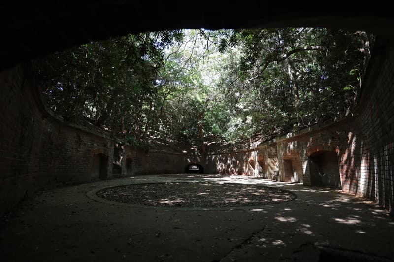
Inside the red brick labyrinth
The approach to Battery No. 3 leads through evergreen forest where cicadas buzz in summer and humidity clings to the stone. Inside, the light thins to a gloom broken by shafts from roof vents and doorways. Water sometimes pools on the floors of the magazines, creating mirror like reflections that photographers love. You can still see lamp recesses cut into the walls, arched doors built for moving shells, and long galleries whose curvature makes the exit vanish from sight.
Not every ruin on Okinoshima is stable. The Second Battery, on a hill nearby, has suffered heavy damage and sections are no longer safe to enter. A posted safety sign at the site warns visitors in direct language. The message is blunt, as safety notices often are.
A safety sign at the Second Battery site reads: ‘Restricted Area. These remains of an artillery battery continue to erode and therefore are very dangerous. Please do not enter this area.’
That warning is well founded. Masonry that looks solid can give way, and a fall in a tunnel is a long way from quick help. Staying on marked paths keeps visitors safe and protects the fabric of a rare surviving coastal fort. On the healthier portions of Battery No. 3, the brickwork remains sound enough for careful exploration, with stairs climbing to former gun positions and passages leading to bunker like rooms used by crews in wartime.
From secret map to social media star
During its service life, Tomogashima was strictly off limits. Wartime authorities restricted access and, according to local histories, the islands even vanished from civilian maps. After the forts were retired and the war ended, the archipelago opened in stages and was folded into Setonaikai National Park. Nature moved in as soldiers moved out. Root systems split joints between bricks and ferns carpeted the platforms.
That slow fusion of architecture and vegetation made the islands a magnet for artists, filmmakers, and location scouts. Fans of animation often compare the scenery to the floating city in Castle in the Sky. Cosplayers use the moody corridors for shoots. Travel media routinely feature the underground vaults and the way afternoon light turns the brick a deeper red.
Social posts helped power a revival in day trips from Osaka and Wakayama City. The experience is more than a backdrop. On busy weekends, the path around Okinoshima becomes a moving classroom as families and students discuss how a nineteenth century shoreline defense worked, then step into the very rooms where soldiers stored powder and shells.
How to visit: ferries, trails, and rules
Okinoshima is reached by a short ferry ride from Kada Port, northwest of central Wakayama City. The crossing to Nonaura port on Tomogashima takes about 20 minutes. Travelers from Osaka can ride the Nankai Line to Kada Station and walk about 15 to 20 minutes to the pier. Round trip adult fares are often 2,200 yen, with child fares around 1,100 yen. Services usually run multiple times a day in the main season and are reduced in winter. Wednesdays often have no service outside holidays. Timetables change with weather and season, so check the operator’s site before you set out.
Official information and schedules are posted by the ferry company. See the latest times here: Tomogashima Ferry timetable.
Once ashore, a loop trail of about 3.3 kilometers leads past the main highlights, including the lighthouse, several batteries, and the Takanosu observatory. Most visitors spend two to three hours walking the circuit, with extra time in the tunnels of Battery No. 3. Trails have gentle gradients but can be slippery after rain. A flashlight helps in the darker corridors.
What to bring and how to plan
There are toilets near the pier and a small cafe at times, but services are limited on the island. Come prepared.
- Wear sturdy shoes. Avoid heels or sandals.
- Carry water, snacks, and a flashlight for tunnels.
- Check the last ferry and arrive at the pier early. Ticket reservations are often not accepted.
- Expect spotty mobile signal in wooded areas.
- Respect closures after storms. Some eastern paths shut for safety.
Camping is allowed only at the Minami Taramizu campsite, a short walk from the pier along a forest path. Reservations must be made online in advance. Facilities are simple and there is no electricity or drinking water on site. Bring all gear and plan to carry all trash back off the island. Fires, fireworks, and beach bonfires are prohibited. Quiet hours apply at night.
- Use only the reserved campsite plot. Groups cannot reserve multiple plots.
- No rental gear is available on the island.
- Turn off lights after 10 p.m. and avoid parties.
- Camping may be denied if ferry service is likely to be suspended due to weather.
Safety and conservation on the islands
Tomogashima is rich in wildlife. In warm months, snakes are active, including the mamushi, a venomous pit viper. Deer and squirrels live on the island, and peacocks were introduced years ago in an attempt to curb the snake population. Give animals space and stay on marked trails.
Storms can lead to closures. After typhoons or heavy rain, the eastern side of Okinoshima may be off limits while authorities assess damage. Coastlines sometimes collect trash carried by currents. Volunteers and local officials periodically remove debris, but visitors should be prepared to pack out everything they bring. Conservation depends on light footsteps and respect for signs.
Many structures are more than a century old. Touching delicate brick and entering posted zones accelerates damage and puts visitors at risk. The safest way to explore is to view crumbling sites from outside barriers and spend more time in the robust spaces of Battery No. 3, where thick walls and clear paths make a careful visit possible.
Beyond the batteries: lighthouse, observatory, and nature
Okinoshima is more than forts and tunnels. On the western tip stands a white lighthouse built in 1872, one of the oldest still in service in Japan. Its western style design stands out against the cobalt sea, and it continues to guide local traffic through the strait. The Takanosu observatory, the highest point on the island, offers wide views of Awaji Island and the rocky coast below. Many visitors picnic on the lawns near the trailheads and linger to watch ferries trace white lines across the bay.
Nature softens every corner of the site. Island guides list hundreds of plant species, from subtropical ferns to coastal pines. Jagaike, also called Snake Pond, is a wetland on the western side where seasonal plants thrive. In summer, the island hums with insects and the shade is welcome. The scenery can be as memorable as the brick vaults, especially when morning fog threads through the trees.
At low tide, a path can appear across shallows to Torajima and its smaller battery remnants. This route can be hazardous and is sometimes closed for safety. Local signs will indicate if the crossing is safe. Always check tides and conditions before attempting it.
Cultural layers: Shugendo, Meridian Square, and wartime heritage
Tomogashima is woven into spiritual and cultural history as well. The islands mark the start of the Katsuragi pilgrimage, associated with Shugendo ascetic practice. Remains of training grounds and waypoints dot the landscape. Near the coast, the Old Navy Listening Office sits built into a cliff, with windows facing the sea and skylights that send beams onto the floor. It looks like a stage set, yet it reminds visitors that these islands once listened for engines and watched for silhouettes on the horizon.
Another stop is Meridian Square, a marker for the 135 degree east longitude line that defines Japan Standard Time. Families pose with one foot on either side of the line. Standing there connects the walk to the routines of daily life across the country, from train timetables to television broadcasts set by that meridian.
Many visitors combine Tomogashima with time in Kada, the fishing town where ferries depart. Awashima Shrine there is known for its collection of dolls and the Hina Nagashi doll floating rite. The candy pink Medetai Train on the Nankai line makes the approach part of the fun. After a day among red brick vaults and sea views, some travelers soak in hot springs near the port before heading back to Osaka.
Highlights
- Battery No. 3 on Okinoshima was completed in 1892 and is the largest of five surviving batteries on the island.
- The Kitan Strait location let Meiji era forts control the southern approach to Osaka Bay.
- Red brick galleries, underground magazines, and gun pits remain. Historic artillery once reached about 7.8 kilometers.
- Tomogashima opened after the war and is now part of Setonaikai National Park.
- Access is by a 20 minute ferry from Kada Port to Nonaura. Round trip adult fares are often 2,200 yen.
- A 3.3 kilometer loop trail connects the lighthouse, batteries, and Takanosu observatory. A flashlight is useful in tunnels.
- Camping is limited to the Minami Taramizu campsite with advance reservation. There is no electricity or drinking water.
- Wildlife includes the mamushi snake. Some paths close after typhoons. Respect posted safety signs.
- Other sights include the 1872 lighthouse, Snake Pond wetland, and Meridian Square marking 135 degrees east.
- Views reach Awaji Island. The ruins draw film crews, cosplayers, and families exploring Meiji era history.