A lifeline under pressure
The Ganges, or Ganga, flows more than 2,500 km from the Himalayas to the Bay of Bengal. Its watershed spans over 1 million square kilometers and sustains more than 650 million people. It feeds farms, cities, industry and a rich web of wildlife. For many it is sacred. For all it is a source of water, food and work. That lifeline is under growing strain as the river runs lower for longer during the dry months and extreme floods arrive with little warning.
- A lifeline under pressure
- What is changing in the Himalayas
- Monsoon shifts and an unpredictable water cycle
- Groundwater and the invisible drain
- Dams, diversions and channel engineering
- Water quality, ecology and public health
- Food, energy and livelihoods at risk
- Cooperation or conflict across borders
- Can the Ganges be revived
- Highlights
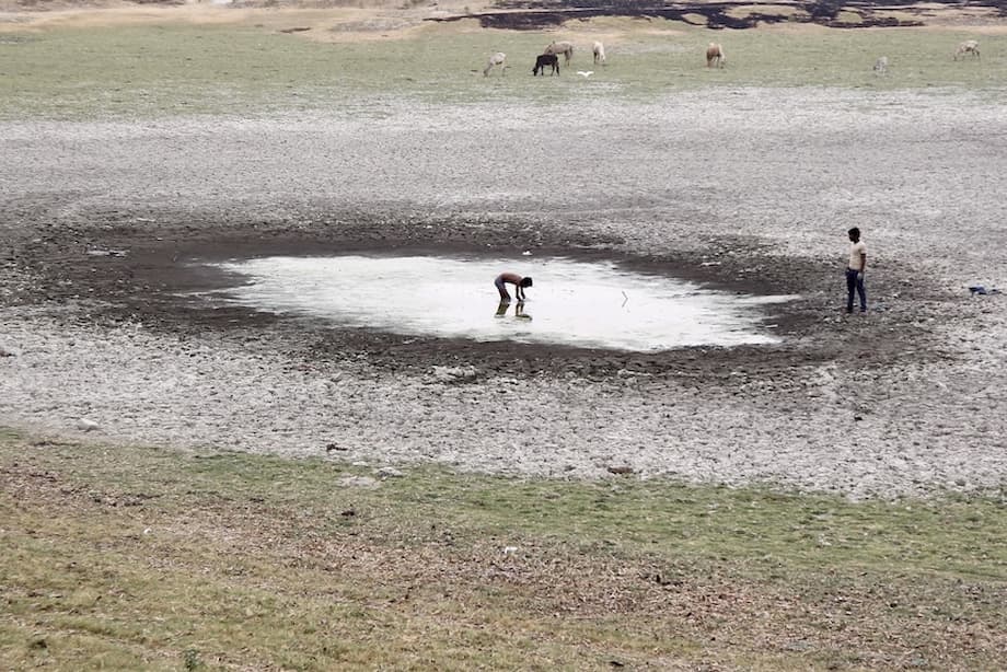
Scientists now see a pattern that ties climate warming, monsoon volatility and human pressure into a single stress test for the basin. Drought clusters have intensified in recent decades. Dry season levels in key reaches have fallen to extremes that many reconstructions suggest are unusual in centuries of regional climate history. Navigation that once continued year round is interrupted. Large boats have run aground in summer shallows where channels used to be reliable. Irrigation canals that flowed for weeks into late season now sit empty earlier.
These outcomes are not driven by climate alone. Thousands of small and large abstractions pull water from the channel. Groundwater pumping supports vast irrigation but lowers the water table. Dams and barrages redistribute flow through gates and canals, often smoothing natural pulses the river needs to recharge wetlands and push back salinity. Pollution compounds stress by degrading water quality and ecosystems that help the river recover. Together these forces are reshaping one of the world’s great rivers with lasting effects on food security, public health and regional stability.
What is changing in the Himalayas
At the source, the Himalayan cryosphere is shifting. A 41 year reconstruction for the Gangotri Glacier System, which feeds the Bhagirathi headstream, shows how the mix of snow, glacier ice, rainfall and groundwater has changed under warming. On average, snowmelt provided about 64 percent of annual flow, glacier ice about 21 percent, rainfall runoff about 11 percent and baseflow about 4 percent. After 1990 the seasonal peak moved earlier on the calendar, from August to July, as winters brought less snow and summer melting and rainfall arrived sooner. That alters the timing farmers and dam operators have relied on for generations.
A separate modeling study of the upper Ganga points to a future with more total discharge in some seasons because of heavier rainfall, while the share from snow and ice shrinks. The analysis projects a large drop in snowmelt contribution by late century, even as total annual flow could be higher, with increases concentrated in the warm months. That pattern delivers short bursts that push flood risk higher and can leave the river weaker during the long dry weeks when communities depend on steady baseflow.
The wider signal is visible across global hydrology. The World Meteorological Organization reported another year of severe glacier mass loss in 2024, with an estimated 450 billion tonnes of ice lost and only one third of major basins experiencing conditions near normal. The agency chief underscored the data gap that hinders planning. In a call for better monitoring and collaboration, WMO Secretary General Celeste Saulo said the region cannot manage what it cannot measure.
‘Continued investment and enhanced collaboration in data sharing are vital to close monitoring gaps. Without data, we risk flying blind.’
For the Ganga headwaters, that means long term field stations to track discharge, snow cover, glacier mass and local weather. Better data improves early warnings for glacial lake outburst floods, supports decisions on hydropower operations and helps forecast dry season water availability downstream.
Monsoon shifts and an unpredictable water cycle
The Ganga depends on the South Asian monsoon, which delivers about 70 percent of the region’s annual rain in just a few months. Recent years brought later onset in some areas, more intense downpours and longer dry breaks. Floods are more severe when large volumes arrive in short windows. Then long rainless spells follow, leaving farmers to navigate both extremes in a single season.
Across Asia in 2024, many basins reported above normal river discharge during the wet months. A strong El Nino, warmer air that holds more moisture and heated seas all contributed to heavy rainfall bursts. India saw deadly floods and landslides in several states. Infrastructure and land management struggled to cope with intense rain over short periods. That picture fits the pattern of a water cycle that swings more wildly between excess and shortage.
Inside the Ganga basin, intense storms send more water over land in fast flash runoff. Less soaks into the ground. Urban areas with paved surfaces add to this effect. Groundwater recharge suffers even in wet years, which sets up deeper stress in the next dry season. Communities then face high water one month and a sharp drop in river and groundwater levels a few months later.
Groundwater and the invisible drain
The Ganga Brahmaputra aquifer is among the fastest depleting on Earth. Studies have estimated water levels falling by about 15 to 20 millimeters each year in some parts of the basin. In rural belts, wells that once buffered households against summer scarcity now yield little. Groundwater quality adds another layer of risk. Pockets of the basin suffer chronic arsenic and fluoride contamination, which threatens health and limits safe supplies when surface flows decline.
New modeling work in Bihar shows why rainfall intensity matters for recharge. Higher annual rainfall does not automatically replenish aquifers if those totals arrive in a few heavy bursts. Scenarios with more low intensity rain produced better recharge and smaller declines. One projection for Nalanda district suggests up to 0.8 cubic kilometers of groundwater could be lost over 42 years if current extraction continues and rainfall arrives in fewer, heavier events. The takeaway is simple. Managing groundwater needs controls on pumping and strategies that favor slow infiltration, not just hope for more total rain.
Agriculture is the main user. Boro rice, water hungry paddy and sugarcane pull large volumes from canals and wells during the dry months. Shifting to less thirsty crops where feasible, improving irrigation efficiency and fixing leaky distribution can cut demand. Community led recharge, from check dams to revitalized ponds, can raise local water tables and restore baseflow into nearby rivers.
Dams, diversions and channel engineering
The main stem of the Ganga and its Himalayan tributaries are deeply engineered. Hundreds of dams and barrages have been built or planned, with gates that move water into canals or into power tunnels. Expert assessments have found that only around 80 km of the river’s 2,525 km course now flows without interruption. Flow fragmentation reduces the river’s ability to move sediment, flush pollution and sustain connected wetlands and floodplains.
A fragile delta
Downstream, the Farakka Barrage on the border zone of India and Bangladesh was designed to manage sediment and navigation, yet it also reduces dry season flow into Bangladesh. Salty water can push farther inland when river discharge is low, a growing threat to the Sundarbans, the world’s largest mangrove forest. Smaller rivers across northern Bangladesh and West Bengal already fall dry in the hot season, leaving communities without reliable water for crops and livestock.
When dams and barrages trap sediment upstream, less silt reaches the delta. That starves the low lying plains of material that would naturally build land. Coupled with land subsidence from groundwater extraction and the weight of new development, the delta sinks. Rising sea level compounds the risk. Some projections point to sea level rise approaching or above 1 meter by century end for the Bay of Bengal, with worst case estimates for the delta as high as around 1.4 meters. Large populations in the lower basin would face higher storm surges, salinity intrusion and displacement without protective planning.
Mountain hydropower can also heighten disaster exposure. Investigations after the 2013 flood in Uttarakhand and the 2021 Rishi Ganga event found that existing and under construction projects increased local risk by adding roads, blasting and debris, then suffered heavy damage when floods arrived. Climate change raises the odds of such outburst floods and landslides. Project design that does not account for shifting extremes can magnify losses.
Water quality, ecology and public health
Flow is only one measure of river health. Water quality across the basin is under pressure from untreated sewage, industrial discharge and agricultural runoff. Lower dry season flows concentrate pollutants. Warmer water speeds some reactions yet can reduce dissolved oxygen. That combination stresses fish and increases the risk of algal blooms.
Kanpur and the industrial corridor
Studies that modeled the heavily industrialized Kanpur stretch tested how climate change, land use and flow shifts would affect key indicators such as dissolved oxygen, biochemical oxygen demand, ammonia, nitrate, phosphorus and fecal coliform. The results show a high risk of eutrophic conditions under many scenarios. Pollutant concentrations rise when streamflow falls. By mid century, the probability of fish kill events increases, driven by more frequent periods of low dissolved oxygen. In the most affected reaches, pollutant loads from sewage and industry dominate, which means that better treatment and stricter enforcement can still deliver large gains even as the climate warms.
Dolphins, turtles and gharials under strain
The Ganga river dolphin, gharials, freshwater turtles and otters depend on clean, connected river habitat. The dolphin population has fallen from tens of thousands to an estimated 1,200 to 1,800 individuals. Barrages fragment habitat and entangle animals in water diversions. Low flow reduces hunting grounds and pushes dolphins into polluted backwaters. Conservation groups and government agencies are expanding protected stretches, improving monitoring and promoting water stewardship with local communities. Those steps work best when paired with environmental flow rules that preserve seasonal pulses and minimum dry month discharges.
Food, energy and livelihoods at risk
Agriculture across the basin is sensitive to shifts in water timing and availability. Earlier snowmelt and an earlier discharge peak reduce water later in the kharif season, then erratic winter rain unsettles rabi planning. Heat stress and longer dry spells cut yields for wheat, pulses and vegetables. Farmers see canals arrive later or close earlier. Wells that once buffered lean weeks are now more likely to run dry. Fisherfolk face fish kills and habitat loss. Urban suppliers struggle to maintain drinking water quality when low flow concentrates pollutants.
Energy systems also feel the strain. Hydropower output depends on both volume and timing. A shift in peak discharge from August to July can upset power scheduling and reduce firm power later in summer. Sediment pulses after cloudbursts clog intakes and erode turbines. Inland navigation, once a reliable mover of grain and bulk goods, suffers when shallow reaches force lighter loads or seasonal shutdowns. The Ganga basin supports a large share of India’s economy, so water stress in this river system translates into higher costs and higher risk for the country as a whole.
Cooperation or conflict across borders
The Ganga is a shared river across India, Nepal and Bangladesh. Managing fluctuating flows, floods and droughts requires shared data and trust. Many existing treaties were written before climate variability was well understood. Agreements need to reflect a wider range of conditions, including low flow thresholds and release rules that protect people and ecosystems downstream.
Regional hydro politics are growing more complex. Recent moves to suspend river treaties on other systems and new plans for large hydropower on Himalayan headwaters outside the Ganga show how water is increasingly treated as a strategic asset. A breakdown in water diplomacy reduces transparency and weakens early warning for floods, which hurts communities on every side of a border. Renewing and updating agreements to include climate science, open data, joint forecasting and fair sharing is now a core task for the region.
The context is not only geopolitical. Early warning systems, flood zoning and drought planning work better when countries pool observations from mountains to delta. Cross border sediment management, wetland conservation and joint pollution control can strengthen resilience for the entire basin.
Can the Ganges be revived
Reversing decline is possible. It calls for a broad set of measures that lower demand, restore natural functions and modernize management with better data.
- Secure environmental flows and protect remaining free flowing reaches so the river can move sediment, dilute pollutants and sustain wetlands.
- Retrofit high risk hydropower and barrages for safety and flexibility, and retire projects that create more risk than benefit in landslide and flood zones.
- Manage groundwater by capping extraction where aquifers are in deficit, metering large users and investing in micro irrigation to improve efficiency.
- Shift crop portfolios toward less water intensive options where suitable, and align minimum support prices and procurement to encourage those choices.
- Recharge aquifers through check dams, percolation ponds and floodplain restoration so more rainwater soaks in rather than runs off.
- Cut pollution at source. Enforce treatment of sewage and industrial effluent, move clusters of tanneries and textiles toward zero liquid discharge, and consider cluster regulation or mergers that internalize upstream to downstream costs.
- Expand hydrometeorological networks, glacier and snow monitoring, and publish open data to strengthen models that guide reservoir operations and drought planning.
- Invest in early warning and risk reduction for glacial lake outburst floods, flash floods and heat stress, with community drills and last mile communication.
- Protect and rebuild the delta by reducing sand mining, planning for sediment delivery, and preparing climate smart relocation where risk is extreme.
- Support community stewardship. Back citizen science, wetland restoration and local river guardians. Programs that link communities, government and businesses can scale practical solutions.
Experience from pilot projects shows results when policies treat the river as a living system, not only a canal for moving water. The effort will pay off in cleaner water, safer cities, steadier farm incomes and a healthier delta.
Highlights
- Recent dry season lows and drought clusters in the Ganga basin align with a long term shift tied to warming, erratic monsoons and heavy human pressure.
- Headwater research shows snowmelt still drives most flow at Gangotri, yet its share is declining and the seasonal peak has shifted earlier since the 1990s.
- Glacier mass loss is accelerating in a warming world, with an estimated 450 billion tonnes of ice lost in 2024 and higher global flood and drought risk.
- More intense downpours and longer dry breaks reduce groundwater recharge even when total annual rain increases.
- Groundwater levels in parts of the basin are falling by around 15 to 20 millimeters per year, with new modeling projecting continued decline without demand management.
- Only a small fraction of the main stem now flows without barriers. Flow fragmentation and sediment trapping raise risks for the delta and the Sundarbans.
- Kanpur and other industrial stretches face chronic pollution. Climate change raises the risk of eutrophication and fish kill during low flow periods.
- Shifts in water timing disrupt farm calendars, hydropower output and inland navigation, raising economic risk across a region that supports hundreds of millions.
- Transboundary cooperation on data, flows and sediment is essential. Treaties need updates that account for climate variability and environmental flows.
- Solutions exist, from environmental flow rules and groundwater reform to pollution control, aquifer recharge, better monitoring and community stewardship.