Singapore’s Coastal Challenge: Why Protection Is an Urgent Priority
Singapore, a city-state renowned for its meticulous urban planning and resilience, faces a mounting existential threat: rising sea levels. With about 30 percent of its land less than five meters above mean sea level, and projections indicating sea levels could rise by up to 1.15 meters by 2100, the nation is at a critical juncture. Unlike other countries that might consider retreating inland, Singapore’s compact geography leaves no room for such options. Instead, the country is embarking on a multi-decade, multi-billion-dollar effort to fortify its vulnerable coastlines, especially the low-lying south-eastern stretch from Pasir Panjang Ferry Terminal to Changi.
- Singapore’s Coastal Challenge: Why Protection Is an Urgent Priority
- Engineering a Line of Defence: Barriers, Tidal Gates, and Raised Platforms
- The Long Island Project: Reclaiming Land for Protection and Growth
- Innovative Legislation and Funding: Ensuring Long-Term Commitment
- Nature-Based Solutions: Harnessing Ecosystems for Resilience
- In Summary
Recent scientific findings have only heightened the urgency. Studies of coral fossils from the Indian Ocean reveal that sea level rise in the region began accelerating as early as 1959, much earlier than previously believed. This acceleration, driven by global warming and shifting wind patterns, underscores the need for robust, forward-looking adaptation strategies. As Professor Paul Kench of the National University of Singapore explained, “The Indian Ocean and South-east Asia have been responding to sea level rise for 70 years already. A lot of the physical changes we see in the landscapes over the decades have already been induced by sea level rise.”
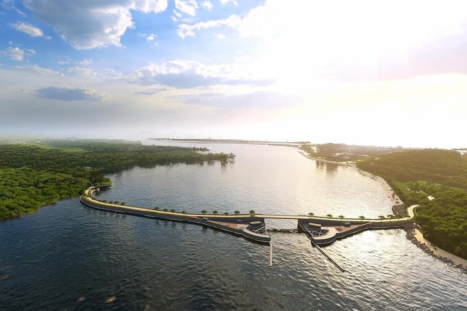
Engineering a Line of Defence: Barriers, Tidal Gates, and Raised Platforms
To address the threat, Singapore’s national water agency PUB has unveiled a comprehensive suite of coastal protection measures, following a four-year, S$18 million site-specific study of the City-East Coast region. The plan, showcased at the nation’s first coastal protection exhibition, is both ambitious and innovative, blending hard infrastructure with nature-based solutions and community input.
The backbone of the strategy is a continuous line of defence along the vulnerable south-eastern coastline. Key components include:
- Coastal Barriers: Massive arm-like structures equipped with gates that can open or close depending on weather and tidal conditions. Three such barriers are planned to connect Sentosa Island to Pulau Brani and the mainland, forming a shield against storm surges and high tides.
- Tidal Gates: Installed at canal outlets, these gates will close during high tide and extreme weather to prevent seawater from inundating inland areas, while remaining open under normal conditions to allow for maritime activities and minimize environmental impact.
- Raised Platforms and Bunds: In areas like Changi Beach Park, raised platforms will be built further inland to preserve intertidal biodiversity and recreational access. Bunds—raised embankments—will double as footpaths or cycling tracks, integrating protection with public amenities.
- Seawalls and Revetments: Existing shoreline defences will be upgraded and, where necessary, new seawalls and revetments (sloped structures that absorb wave energy) will be constructed or raised, particularly in Changi South and along the Greater Southern Waterfront.
These measures are designed to be flexible and adaptive, with detailed engineering and environmental impact assessments to follow. Construction is targeted to begin in the 2030s, with phased implementation to ensure sustainability and cost-effectiveness.
Learning from Global Best Practices
Singapore’s approach draws inspiration from international examples, such as the Thames Barrier in the United Kingdom and the Maeslantkering in the Netherlands. These storm surge barriers have proven effective in protecting low-lying cities from catastrophic flooding. However, Singapore’s unique context—dense urban development, limited land, and a tropical climate—requires tailored solutions. The barriers here are designed to remain open most of the time, preserving sea views and maritime activity, and closing only when necessary to block storm surges or extreme high tides.
The Long Island Project: Reclaiming Land for Protection and Growth
At the heart of Singapore’s coastal defence is the visionary Long Island project. First conceptualized in 1991 and revived in recent years, Long Island involves reclaiming about 800 hectares of land off East Coast Park—twice the size of Marina Bay. This reclaimed land will serve multiple purposes:
- Physical Barrier: Acting as a buffer against rising seas and storm surges, shielding the mainland from direct impact.
- New Reservoir: Creating Singapore’s 18th reservoir to enhance water security.
- Urban Development: Providing space for new homes, recreational areas, and amenities, supporting future population and economic growth.
- Recreational Opportunities: Adding around 20 kilometers of new waterfront parks and green spaces for public enjoyment.
Site investigation works for Long Island began in August, with marine surveys and soil sampling underway to inform detailed design and planning. The project is a testament to Singapore’s integrated approach—combining flood protection, water supply, and urban development in a single, forward-thinking initiative.
Balancing Protection, Biodiversity, and Public Access
One of the challenges in designing coastal defences is balancing technical feasibility, cost, and environmental impact. For instance, building barriers at the narrowest parts of channels may be more economical but could disrupt sensitive habitats like mangroves and rocky shores. To address this, PUB and partner agencies are conducting rigorous environmental impact assessments and engaging with stakeholders—including residents, nature groups, and businesses—to incorporate feedback and preserve biodiversity.
At Changi Beach Park, for example, the decision was made to position raised platforms and bunds further inland, allowing the beach to flood temporarily during extreme high tides while maintaining access and protecting seagrass-rich shores. Safety measures will be in place for visitors during such events. This approach reflects a broader trend in Singapore’s urban planning: integrating resilience with liveability, ensuring that protective measures do not come at the expense of public enjoyment or ecological health.
Innovative Legislation and Funding: Ensuring Long-Term Commitment
Coastal protection is a long-term, resource-intensive endeavor. Estimates suggest that Singapore may need to invest up to $100 billion over the next century to safeguard its shores. To ensure sustained funding, the government has established a dedicated Coastal and Flood Protection Fund with an initial allocation of $10 billion, supplemented by annual budget allocations and, if necessary, government borrowing.
Legislation is also being prepared to define stakeholder roles, enforce standards, and safeguard land needed for protection measures. A new Coastal Protection Bill will be introduced to Parliament, and a code of practice for coastal protection is set to be launched by 2026. Property owners are encouraged to invest in flood resilience, as adaptation will require collective effort across society.
Community Engagement and the Role of Technology
Singapore’s coastal protection strategy is notable for its emphasis on community engagement and technological innovation. Since 2024, more than 3,000 people have participated in public consultations, expressing support for proactive measures and offering ideas to enhance resilience. The government has incorporated feedback on preserving sea views, maintaining public access, and integrating recreational features into the design of new defences.
Technology plays a critical role as well. Advanced monitoring systems, digital twins (virtual models of physical infrastructure), and real-time data analytics are being explored to forecast floods, simulate the effects of extreme weather, and optimize the design of both hard and nature-based solutions. These tools enable Singapore to stay ahead of evolving climate risks and refine its strategies as new information emerges.
Nature-Based Solutions: Harnessing Ecosystems for Resilience
While hard infrastructure forms the backbone of Singapore’s coastal defence, nature-based solutions are increasingly recognized as vital complements. Mangrove forests, for example, can trap sediment and keep pace with rising seas, while seagrass meadows and coral reefs help buffer wave energy and support biodiversity. Recent scientific advances, such as the analysis of ancient coral microatolls, are helping researchers understand how these ecosystems have responded to sea level changes over decades and how they can be harnessed for future protection.
Professor Adam Switzer, a coastal science expert at Nanyang Technological University, emphasized the importance of combining traditional field data with modern modeling:
“New sea level insights from coral records like these are helping South-east Asia and Singapore sharpen climate models and unlock smarter, nature-based solutions, like reef and mangrove restoration, to build resilient coastlines for the future.”
Integrating Coastal Protection with Urban Development
Singapore’s approach is not just about survival—it’s about creating a liveable, vibrant city for generations to come. The upcoming Changi Airport Terminal 5, for example, will feature an elevated airfield as part of its flood resilience strategy. Cycling paths along the shoreline may be raised to double as coastal defences, blending recreation with protection. The Greater Southern Waterfront, envisioned as a major urban gateway, will integrate new residential, commercial, and green spaces with robust shoreline upgrades.
These efforts are part of a broader vision to transform Singapore into a model of urban resilience and sustainability. As cities worldwide grapple with the dual challenges of development and climate adaptation, Singapore’s experience offers valuable lessons in planning, innovation, and community partnership.
In Summary
- Singapore is highly vulnerable to rising sea levels, with about 30 percent of its land less than five meters above sea level.
- By 2100, sea levels around Singapore could rise by up to 1.15 meters, making coastal protection an existential priority.
- The government is implementing a comprehensive strategy featuring coastal barriers, tidal gates, raised platforms, and the ambitious Long Island land reclamation project.
- Measures are designed to balance technical feasibility, cost, biodiversity, and public access, with extensive community engagement and environmental assessments.
- Funding comes from a dedicated $10 billion Coastal and Flood Protection Fund, annual budgets, and possible government borrowing.
- Legislation and a new code of practice will ensure long-term commitment and clear stakeholder responsibilities.
- Nature-based solutions, such as mangrove and reef restoration, complement hard infrastructure to enhance resilience.
- Technology and public participation are central to Singapore’s adaptive, forward-looking approach.
- Construction of major defences is expected to begin in the 2030s, with phased implementation and ongoing refinement.
- Singapore’s integrated strategy serves as a model for other coastal cities facing the realities of climate change.