A new blue route across eastern Beijing
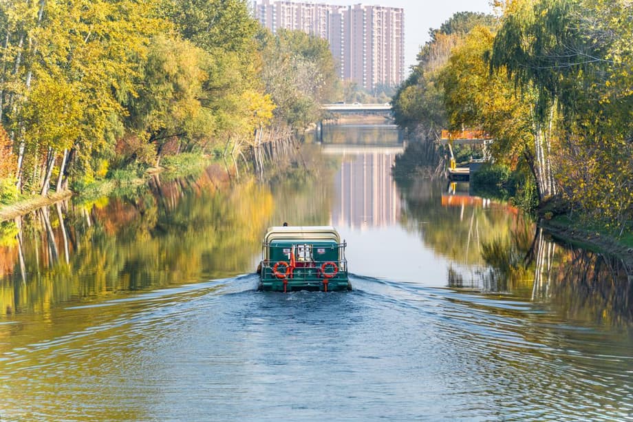
Beijing has begun trial operations on a 15 kilometer boat route that links Chaoyang and the municipal administrative center in Tongzhou. The journey starts at INDIGO Harbor on the Bahe River, then continues east to the Wenyu River. City planners describe the corridor as a showpiece for a cleaner, greener capital. Boats glide past tree lined banks, bridges, and public plazas, giving residents a new way to see neighborhoods that many only knew from streets or metro trains. The opening represents a step in a longer effort to bring life back to urban rivers that once served mainly as drainage and flood channels.
- A new blue route across eastern Beijing
- Where the route runs and what riders see
- Why Beijing is betting on urban waterways
- How far the corridor could reach by 2030
- Lessons from Liangma River and other cities
- Environmental safeguards and challenges
- What riders and businesses can expect in the trial period
- What to Know
The line is more than a sightseeing excursion. By tying together riverside districts with thriving arts and commerce, the project seeks to kickstart local spending and draw visitors beyond familiar tourist zones. Stops near Taikoo Place Beijing, Langyuan Station, and the 798 751 Art District position the route within a belt of creative venues, cafes, and small galleries. Water based travel can complement walking and cycling, creating days when residents shop, eat, and attend events without relying on a car. City officials say the trial will inform future links planned for the 15th Five Year Plan period.
The opening also fits a wider trend in the capital. Over the past decade, investments have upgraded riverbanks with plantings, terraced edges, and new paths so that flood works double as parks. The new river service turns these improvements into a linked experience on the water. It gives residents and tourists a clean, low speed way to reach busy districts without adding to traffic, and it gives small businesses a steady flow of foot traffic at different times of day.
Where the route runs and what riders see
INDIGO Harbor, the western launch point, sits beside a popular shopping destination on the Bahe River. The Bahe has been landscaped in recent years, with promenades, seating, and new plantings that soften once hard embankments. From there, boats head toward Tongzhou along calmer reaches where the city opens up to water. The Wenyu River is broader, with long sightlines and busier recreation on its banks. The two rivers together frame a cross section of contemporary Beijing, from sleek business campuses to converted industrial yards.
A seasonal cityscape on the water
Designers want the river corridor to change with the calendar. Spring brings blossoms and fresh greens. Summer shade comes from willows and poplars. Autumn colors arrive in layered gold and rust. Winter offers crisp views and, on clear days, reflections that turn bridges into arches of light. Night lighting and art programming will likely make certain stretches active after dusk, extending the waterfront beyond daytime hours.
Riders can expect a different perspective even in familiar neighborhoods. Waterfront paths sit below street level in some segments, which quiets traffic noise and creates intimate coves where benches and small piers meet the water. Above, landmark sites such as the 798 751 Art District are close enough for short walks from planned docks. The format lends itself to hop on, hop off days, where families and visitors sample multiple spots along the route.
Why Beijing is betting on urban waterways
Cities worldwide are rediscovering rivers as transportation corridors and public rooms. A short water link will not replace subways or buses, yet it adds another layer of choice for weekend trips, short commutes, and cultural outings. More important, the project builds a network of destinations along the banks. Riverfront streetscapes, boat piers, and plazas knit together places that were once separated by speeding traffic or fenced floodworks.
Waterways also support a cleaner and cooler city. Riparian vegetation filters runoff before it reaches the channel. Shaded banks reduce heat in adjacent blocks during summer. Flood terraces and wetlands can store and slowly release stormwater. Many Chinese cities pursue a sponge city approach that uses parks, bioswales, and permeable surfaces to capture rain where it falls. A river route that brings people to these landscapes makes their value visible.
Public attitudes change when air and water quality improve and when attractions line the banks. In Beijing, the Liangma River shows that transformation is possible. Once treated as a drainage ditch, it now draws joggers, parents with strollers, and visitors looking for cafes and small boats. Other capitals offer useful comparisons. Paris has reopened parts of the Seine for recreation after large investments in wastewater control. Chicago is building reservoirs and creating floating wetlands, a mix of hard infrastructure and nature based fixes.
How far the corridor could reach by 2030
The Chaoyang plan outlines a continuous 43.4 kilometer corridor that stitches the Bahe to the Beihucheng reach upstream and to the Qinghe Wenyu and Beiyun rivers downstream. That would link a series of parks, business clusters, and residential areas along the eastern side of the city. Such a through route would simplify boat operations and create longer itineraries for visitors and residents.
A blue green urban grid
Integration matters as much as distance. Designers envision riverbank greenways that run beside the channel, with crossings that sync to municipal roads and park entrances. The aim is to let someone step off a boat, follow a shaded path, and reach transit within minutes. Continuous walking and cycling paths, frequent seating, and barrier free ramps would turn the waterway into a spine for daily life rather than a one time attraction.
Connections of this type require careful coordination. Water releases from upstream reservoirs affect depth. Locks, weirs, and bridges shape where boats can pass. Bank restoration must protect habitat while allowing safe boarding and access for maintenance. A strong operations plan, clear signage, and reliable information will be as important as the hardware in the water.
Lessons from Liangma River and other cities
The Liangma River revival, a few kilometers north of the new route, offers a local case study. For decades, the area functioned as a service corridor. Investment in water quality, plantings, shade trees, footbridges, and public art shifted the river into a neighborhood centerpiece. Small rental craft and cafes arrived as people returned to the banks. That success built demand for more waterfront links and showed how programming can extend activity through different seasons.
Paris provides another lens. A century of combined sewers meant heavy rain sent untreated flows into the Seine. The city spent years adding storage basins and upgrading treatment so that overflow events are rarer and shorter. Those investments enabled outdoor swimming events around the 2024 Olympics and will support future public bathing spots tied to neighborhood parks.
Chicago faced a different history. Engineers reversed the river more than a century ago to protect Lake Michigan. Industrial discharges and storm overflows followed, which damaged habitat and public trust. The current program combines extra large reservoirs and deep tunnels with a new wave of projects such as the Wild Mile, a floating wetland that filters water and creates habitat for fish and birds. Even as the river gets cleaner, officials work to convince residents that it is a place to visit, not just an obstacle to cross.
Environmental safeguards and challenges
Academic studies of Beijing waterfronts point to uneven ecological quality across the city, with many reaches in the south and center still lagging. Researchers recommend ecological shorelines that replace concrete edges with planted terraces, small coves, and gentle slopes. Constructed wetlands upstream of busy segments can trap sediment and nutrients. Using native vegetation improves resilience, lowers maintenance, and supports insects and birds that thrive in local conditions.
Navigation design also matters. River depth fluctuates by season and storm. Dredging can harm habitat if not managed with timing windows and silt controls. Winter ice may pause service for weeks. Summer downpours can bring cloudy, fast moving water, so operators need protocols for delays and safety closures. Low wake hulls, speed limits, and attention to fish passage at structures can limit disturbance.
The social side deserves equal attention. Waterfront upgrades can raise rents and push out small vendors if planning is not inclusive. Cities that keep public edges open, reserve spaces for community events, and support local markets often see stronger long term support. Routine upkeep, from litter crews to pruning, is decisive. Publishing water quality data and soliciting rider feedback builds trust as the trial evolves into regular service.
What riders and businesses can expect in the trial period
Trial operation is the time to learn. Crews test docks, refine boarding procedures, and collect data on boarding times and demand patterns. Schedules can shift as operators identify bottlenecks. Ticketing, safety briefings, and customer information are adjusted from week to week. The goal is a reliable, pleasant experience that can scale when more segments of the corridor open.
For riders, the river is likely to feel like a new kind of weekend or evening outing at first, then a modest commuting option for people who live or work near the banks. Clear wayfinding that links docks to nearby subway stations and bus stops will help. Bike parking, shade canopies, and barrier free ramps can make the system practical for a wide range of users, including parents with strollers and older adults.
Businesses along the banks can plan pop up events, riverside markets, and partnerships with cultural venues. Cross promotion between boat operators and galleries or performance spaces can encourage multi stop itineraries. If trial feedback is positive, more docks and more frequent service are likely to follow as the 43.4 kilometer plan advances through 2030.
What to Know
- Beijing has opened a trial 15 kilometer boat route linking Chaoyang and Tongzhou via the Bahe and Wenyu rivers.
- The line connects cultural and commercial hubs such as Taikoo Place Beijing, Langyuan Station, and the 798 751 Art District.
- The waterfront is designed to offer seasonal scenery with plantings, lighting, and public paths along the banks.
- Chaoyang plans a 43.4 kilometer corridor during the 15th Five Year Plan period, tying the Bahe to the Beihucheng, Qinghe Wenyu, and Beiyun systems.
- Design calls for integrated waterways, greenways, and walking paths that link to parks and nearby transit.
- Environmental measures include ecological shorelines, wetlands, native plants, and operating protocols for variable river conditions.
- The trial will test docks, schedules, ticketing, and safety, and gather feedback to refine service.
- Experience from the Liangma River, Paris, and Chicago shows that cleaned up rivers and clear programming can change how people use urban waterways.