Floods swamp Cebu as evacuations surge
At least 26 people have been killed and hundreds of thousands fled their homes after Typhoon Kalmaegi unleashed torrential rain and dangerous floods across the central Philippines, officials said Tuesday. Investigators are still confirming reports from isolated towns. Local authorities in several provinces warned the toll could climb as crews reach cut off neighborhoods.
- Floods swamp Cebu as evacuations surge
- How strong is Kalmaegi and where is it heading
- Rescues stretched thin after air force helicopter crash
- Why the flooding was so severe in Cebu
- Compounding disasters and a stretched recovery
- Transport and power disrupted across the Visayas
- What residents and officials are saying
- What happens next
- Climate background and the science behind stronger storms
- What to Know
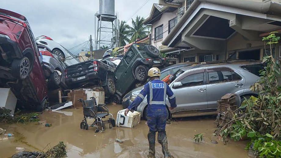
Nearly 400,000 people moved preemptively to safer ground before landfall, according to the national disaster agency. More than 100,000 of them sheltered in evacuation centers in Cebu province. Floodwaters raced through entire communities on the island of Cebu, lifting cars and even shipping containers and driving families to upper floors and rooftops to survive.
The storm, locally named Tino, weakened after coming ashore yet kept a broad rain field and strong gusts. By Tuesday afternoon it was sweeping west across the Visayas toward Panay, Guimaras and Palawan, with forecasters expecting the center to move into the South China Sea by Wednesday.
Officials said the flooding in metro Cebu was sudden and severe after extreme rainfall. Weather stations measured about 183 millimeters of rain in 24 hours around Cebu City, already more than the area usually gets in an average month. Rivers overflowed, drainage canals backed up, and rescue teams struggled to keep up with distress calls.
Pamela Baricuatro, the Cebu provincial governor, said the scale of inundation took many by surprise, and that water was more dangerous than the wind in this storm.
The situation in Cebu is really unprecedented. We were expecting the winds to be the dangerous part, but the water is what is putting our people at risk. The floodwaters are devastating.
Rescuers in boats and military trucks worked through the night, but access remained difficult in streets choked with debris and fast water. Authorities urged residents to avoid flood currents and to heed orders to evacuate low lying barangays.
How strong is Kalmaegi and where is it heading
The state weather agency PAGASA said Kalmaegi carried sustained winds near 130 kilometers per hour, with gusts up to 180 kph, at points on Tuesday. Earlier on its track, peak winds were near 95 miles per hour, with higher gusts. The system was moving west across the Visayas at about 25 kph, maintaining a large rain shield that extended far from the center.
Forecast guidance showed the core traveling toward the islands of Panay and northern Palawan, then exiting into the South China Sea. Authorities in Vietnam signaled early preparations as the storm approaches the central coast later this week. Another weather disturbance was organizing east of Mindanao, a reminder that the season is not over.
Rainfall and surge risk
Forecasters warned of more intense rainfall in central islands and parts of southern Luzon, with a risk of flash floods and landslides in saturated slopes. Coastal communities faced storm surges that could exceed three meters in some bays and inlets, especially where onshore winds pile water into shallow coasts. Surge is a dome of sea water pushed ashore by the storm. It can flood areas well beyond the beach and can arrive quickly.
Rescues stretched thin after air force helicopter crash
As flood rescues expanded, the Philippine Air Force reported that a helicopter on a humanitarian mission crashed in Agusan del Sur on northern Mindanao. The aircraft had five personnel on board. Search and rescue teams were deployed to the area, but there were no immediate reports on survivors.
In a brief statement, the Air Force described how it lost contact with the crew during a damage assessment flight.
Communication with the helicopter was lost, which immediately prompted the launch of a search and rescue operation. Details will be released as they are verified.
Strain on response teams was evident in worst hit parts of Cebu. In the coastal town of Liloan, residents climbed to rooftops as brown water surged through streets. In Mandaue City, people waded in water up to head level, while vehicles were submerged or drifting. Volunteers and first responders were forced to wait for waters to recede in some districts to avoid putting crews in danger.
Gwendolyn Pang, secretary general of the Philippine Red Cross, said responders faced more calls than they could answer in the first hours of the disaster.
Many calls for rescue could not be answered due to debris and high water levels.
Local governments opened more temporary shelters and moved food, potable water, and dry clothing into flooded barangays as access allowed. Medical teams focused on preventing injuries from contaminated water, electrical hazards, and infection.
Why the flooding was so severe in Cebu
Kalmaegi was not the strongest wind event to hit the Visayas in recent years. The storm was intense in a different way. It was a wide, rain heavy system that parked bands of thunderstorms over the same areas for hours. Around Cebu City, gauges recorded 183 millimeters of rain in a single day, pushing rivers over their banks and saturating ground that was already wet from recent storms.
Urban growth has increased the number of paved surfaces that do not absorb water. When intense rain falls on cities, it runs quickly into drains, canals, and low lying neighborhoods. If channels clog with debris or tide levels are high, water backs up into streets and homes. Several bridges and culverts reported blockages, which compounded runoff from upland barangays.
Meteorologists also pointed to a shear line, a narrow zone where winds from different directions meet. The boundary can intensify rainfall when a tropical cyclone passes nearby. The combination of Kalmaegi and the shear line helped squeeze out moisture over the central islands, a setup that can turn a strong storm into a severe flood event.
Past experience shows that surge and rainfall flooding are different hazards. Surge is driven by wind and low pressure pushing the sea inland. Rainfall flooding comes from water that cannot drain fast enough. Cebu saw both, though the greatest danger this time was inland floodwater racing through settlements far from the shoreline.
Compounding disasters and a stretched recovery
The storm struck barely a month after a magnitude 6.9 earthquake killed and injured residents in the central Philippines, with Cebu absorbing heavy damage. Thousands have been living in tents or in damaged homes. Many of them had to evacuate again as Kalmaegi approached. That double blow strained shelter capacity and complicated relief distribution.
This year has already brought a series of damaging weather systems. Super Typhoon Ragasa in late September, followed shortly by Typhoon Bualoi, left dozens dead and damaged roads, bridges, and crops. A wetter than usual monsoon season flooded parts of the country before the typhoons. That pattern drew public anger over unfinished or substandard flood control projects that residents say have left communities exposed.
Disaster managers said the country has reached its average of about 20 storms and typhoons for the year, with more possible before December ends. With many river systems still high and upland slopes saturated, even moderate rain can trigger fresh flooding or landslides in coming days.
Transport and power disrupted across the Visayas
Air and sea travel halted as the storm crossed the archipelago. Airlines canceled more than 180 domestic flights into and out of affected cities. Interisland ferries and many fishing boats stayed in port, stranding over 3,500 passengers and cargo drivers at nearly 100 seaports, according to maritime authorities.
Power service failed in pockets of Cebu and nearby provinces. Flooded substations and downed lines kept neighborhoods in the dark overnight. Telecommunications were intermittent in several cities on Tuesday, slowing the work of search teams and making it harder for families to reach loved ones.
In Eastern Samar, strong winds damaged hundreds of homes on Homonhon island, many of them small rural houses. There were no reports of deaths on the island, but rebuilding will take time. In Cebu City, officials reported that the worst of the water began to recede by midday, leaving mud, debris, and damaged vehicles across key roads.
What residents and officials are saying
Eyewitness accounts from Cebu captured the speed and depth of the flooding. One resident, Don del Rosario, sought safety on an upper floor as water rose around his building, describing the storm as the worst he had experienced in his 28 years in the city.
It is by far the worst we have experienced.
Local government leaders repeated calls for families in flood plains to leave early when warnings are issued. They also urged people to avoid walking or driving through moving water. Even shallow flows can knock a person off their feet, and hidden hazards lurk under opaque floodwater.
What happens next
Kalmaegi is forecast to continue west across the Visayas, bringing heavy rain to parts of Panay, Negros, and northern Palawan before it moves into the South China Sea. Dangerous seas will persist around the storm even as winds ease near the center. Authorities warned that storm surge and river levels could remain high for several tide cycles.
Emergency crews are conducting search and rescue in Cebu and surrounding provinces, while clearing roads to restore access for relief. The government said it had released initial emergency assistance to support evacuation centers and local governments, with more supplies en route as weather allows.
Beyond the Philippines, coastal communities in central Vietnam prepared for possible landfall later in the week. Forecasters will also monitor a developing system east of Mindanao that could bring more rain to the south. People in flood affected areas of the Philippines were told to watch for official bulletins, to boil water if supplies are contaminated, and to stay away from downed power lines.
Climate background and the science behind stronger storms
Warmer seas and a warmer atmosphere can load storms with more moisture. For every degree Celsius of warming, the air holds about 7 percent more water. When that water condenses in thunderstorms, it can fall as heavier rain. Tropical cyclones also tend to intensify more quickly over warmer water. That does not mean every storm is stronger than the last, but it raises the odds of destructive rainfall events like the one that hit Cebu.
Climate patterns also shape storm seasons. La Nina, a climate pattern that cools the central and eastern equatorial Pacific Ocean, is linked with a more active typhoon season in the western Pacific. During La Nina, steering winds and ocean heat often favor more storms tracking near the Philippines. Scientists caution that climate change and natural patterns can interact in ways that increase risk to communities that are already exposed.
What to Know
- At least 26 people were confirmed dead in central Philippines, with officials warning the toll could rise as reports are verified.
- Nearly 400,000 people evacuated before landfall, and more than 100,000 sheltered in centers in Cebu province.
- Flooding overwhelmed entire towns in Cebu, with cars and shipping containers swept along fast moving water.
- A Philippine Air Force helicopter with five personnel crashed in Agusan del Sur during a relief mission. Search operations are ongoing.
- Cebu City recorded about 183 millimeters of rain in 24 hours, exceeding its monthly average.
- Airlines canceled more than 180 flights, and ferries were halted, stranding over 3,500 passengers at seaports.
- PAGASA warned of storm surges over three meters in vulnerable coasts and of landslides on saturated slopes.
- The storm is moving west toward Panay and Palawan, then into the South China Sea. Vietnam is preparing for possible landfall later this week.
- The disaster follows a 6.9 magnitude earthquake in late September and a string of strong storms in recent weeks.
- Warmer oceans and La Nina can increase the chance of extreme rainfall in typhoons that pass near the Philippines.