Floods force Bali to rethink building on farmland
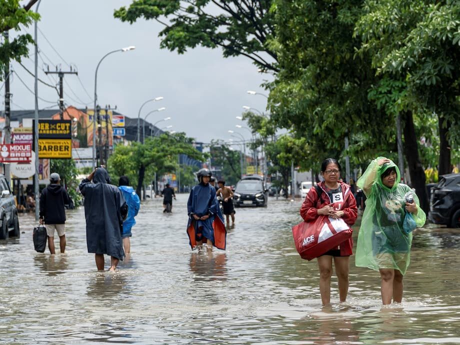
Bali will halt new approvals for hotels, restaurants, and other commercial facilities on rice fields and productive agricultural land after flash floods killed at least 18 people and inundated wide areas of Denpasar and nearby regencies. Authorities declared a state of emergency on 10 September after the heaviest downpours in more than a decade overwhelmed rivers, clogged drains, and low lying neighborhoods. The decision marks a decisive shift in how the island balances tourism growth with safety, food security, and environmental protection.
- Floods force Bali to rethink building on farmland
- What the new ban covers
- Why rice fields and forests matter for flood safety
- Climate change and extreme rainfall in Indonesia
- Overtourism and a changing landscape
- Waste, drainage and the anatomy of the flood
- Voices from the island
- Tourism and business impact
- Timelines, enforcement and what comes next
- What to Know
Governor I Wayan Koster said instructions have been issued to regents and mayors to stop issuing permits for new tourism facilities on productive land, especially rice fields. Provincial bylaws are being drafted and are expected to be in force by the end of 2025. From 2025 onward, Bali will no longer allow the conversion of productive land into commercial use, in line with a 100 year plan for the island.
National officials are backing the provincial move. Indonesia’s environment minister, Hanif Faisal Nurofiq, called the policy a vital step to protect lives and the tourism economy after days of mud, debris, and blackouts revealed how exposed the island is when extreme rain arrives.
The flood toll stands at a minimum of 18 dead, with several people reported missing in the early days. Markets, shops, and homes were damaged across Denpasar, Badung, and Gianyar. Cleanup crews have already removed hundreds of tonnes of flood waste from riverbanks and streets. With the wet season just beginning, authorities warn that more intense storms are possible in the coming months.
What the new ban covers
The governor’s instruction targets the conversion of productive land, a category that includes rice fields and other parcels that support farming and food supply. It halts new permits for hotels, restaurants, and similar facilities on those lands. Officials say projects that already have valid permits can proceed, but any fresh proposal that would convert farms into commercial plots should be rejected.
Construction remains possible in zones already designated for tourism or residential use, provided developers hold the correct permits and comply with set back rules along rivers, coasts, and steep slopes. The ban is intended to create breathing room while the province prepares a revised spatial plan backed by a strategic environmental review. Authorities say the policy will be applied consistently in priority districts such as Denpasar, Badung, Gianyar, and Tabanan, where development pressure and flood risk are high.
Why rice fields and forests matter for flood safety
Rice terraces and surrounding green belts are more than a postcard view. They function as a water management system. In Bali, the traditional subak irrigation networks move and store water through terraced paddies and canals. When rain is heavy, tiled rooftops and paved streets shed water as fast runoff. Rice fields and forests slow water down, spread it across the landscape, and allow part of it to seep into the soil. This reduces peak flows that can burst riverbanks or overwhelm drains.
As farmland is converted into villas, parking lots, and new roads, the island loses this natural sponge. The environment ministry says the Ayung River Basin, which covers Denpasar and parts of Badung, Gianyar, and Tabanan, has only about 3 percent tree cover left. That is too little to absorb and slow intense rainfall. When slopes that once held trees or paddies are stripped or paved, water moves faster into channels and low lying areas, raising flood heights and speeds.
Forests also stabilize soil. Without roots and leaf litter, rain can dislodge sediment that silts up rivers and drains. The combination of faster runoff and clogged waterways increases the chance that a short burst of extreme rain leads to flash flooding.
Climate change and extreme rainfall in Indonesia
Climate scientists have long warned that warming air holds more water vapor. When storms form in warmer conditions, they can dump more rain over a short period. Southeast Asia’s wet season typically runs from September to March. In recent years, parts of Indonesia have seen heavier downpours and more frequent flash floods, even when total seasonal rainfall is within past ranges. The difference is the intensity and timing of rain events.
Indonesia’s meteorology and climate agency has cautioned that the current rainy season could be intense. The agency’s alerts do not guarantee a specific outcome, but they suggest a higher chance of extreme rain clusters, including on popular tourist coasts in southern Bali. Flood risk is shaped by both weather and human choices. Drainage networks, land use, tree cover, building set backs, and waste management determine whether heavy rain leads to nuisance street flooding or a dangerous disaster.
Overtourism and a changing landscape
Tourism is the backbone of Bali’s economy. Visitor numbers have rebounded strongly, with officials expecting around 6.5 million international arrivals this year. That surge has brought jobs and investment, but it has also reshaped the island’s land use. Villas, hotels, and cafes have spread from beach hubs into inland villages where rice paddies once dominated.
Local planners and environmental groups say the pace of land conversion in key tourism districts has been steep. By their estimates, between 3 and 6 percent of agricultural land in these districts has been converted each year in recent times. Residents describe a pattern where green belt protections are ignored, setbacks along rivers and coasts are overlooked, and projects push into slopes and flood plains. The result is a patchwork of new roofs, walls, and parking areas in places that used to slow and absorb rainwater.
Complaints have grown about congested roads, polluted waterways, and pressure on water supply. Healthier tourism depends on infrastructure that keeps pace, along with rules that reserve sensitive land for food production and flood safety.
Waste, drainage and the anatomy of the flood
Heavy rain alone does not explain the scale of flooding in Denpasar. Drainage systems are the island’s first line of defense. When drains are blocked by trash and sludge, water backs up and spills into streets and homes. City crews reported that early in the wet season, before the floods, many channels were already choked. The recent disaster multiplied the problem by pushing debris and mud into markets and river corridors.
Officials say more than 200 tonnes of flood waste have been collected, with teams continuing to clear clogged points in Denpasar and along the Badung River. Residents and traders have criticized chronic waste management problems, pointing to a landfill closure that spurred illegal dumping into waterways. The Suwung landfill has been reopened temporarily to handle debris and restore basic sanitation. Long term, Bali will need consistent waste collection and enforcement to keep drains clear before the heaviest rains set in.
Voices from the island
Residents across the capital described flooding that rose faster and higher than anything they had experienced. Their accounts reflect both shock and a conviction that unchecked development has reduced the island’s ability to cope with heavy rain.
Denpasar resident Putu Oka Darmiati, who has lived in the same neighborhood for decades, said the water rose before dawn as she prepared for a family ceremony.
We moved here in 1975, we had flooding in 1989, but this was the worst.
In another neighborhood, 85 year old Wayan Sundri said water reached levels never seen in her lifetime.
I have lived in this home my entire life, and it has never flooded that high. Ever.
After the floods, Governor I Wayan Koster outlined the steps the province is taking to stop land conversion for commercial projects.
Starting this year, there is an instruction to all regents and mayors across Bali. After handling the floods, we will meet again to ensure no more permits are issued for hotels, restaurants or other facilities on productive land, especially rice fields. From 2025 onward, no productive land can be converted into commercial facilities.
Indonesia’s environment minister, Hanif Faisal Nurofiq, praised the decision and urged immediate action to enforce it.
This is crucial for Bali’s tourism as the recent flooding has drawn serious attention. I really hope the governor will immediately stop the land conversions in Bali. This is extremely important.
Environmental advocates say years of rapid construction in unsafe areas have reduced the island’s natural defenses. Made Krisna Dinata, executive director of Walhi Bali, described how building choices have intensified risk.
Much tourist accommodation is built by violating coastal zones, river zones, and often in disaster prone areas.
Tourism and business impact
Industry leaders in Bali’s hospitality sector say there is already ample accommodation to serve visitors. Local hotel and restaurant associations in busy districts support a pause on new permits for projects on farmland, arguing that supply has outpaced demand in some areas and led to pricing battles. A period of restraint could steer investment toward quality upgrades, better infrastructure, and safer sites.
Developers point to the importance of zoning. In Bali, green zones are reserved for agriculture and conservation, yellow zones are authorized for tourism uses, and red zones are primarily for housing and local businesses. The new ban does not shut down all building. It raises the bar for where and how projects can proceed. For investors, the message is to work within the zoning map, secure the correct permits, and plan with flood risk in mind. Projects that respect setbacks, incorporate on site retention of stormwater, and strengthen local drainage are more likely to move forward.
Real estate analysts expect farmland values to stabilize where conversion is blocked, while approved tourism zones may see higher prices for suitable plots. The policy could redirect capital from speculative builds on rice fields toward improvements in established corridors, including retrofits that reduce runoff, use permeable pavements, and add water storage features.
Timelines, enforcement and what comes next
The immediate step is administrative. Districts and cities have been told not to issue permits for new hotels, restaurants, or similar facilities on productive land. The province plans to finalize bylaws by the end of 2025 to lock the policy into the spatial plan. National and provincial agencies say they will pair the ban with enforcement actions against illegal buildings in river corridors and protected coastlines.
Officials have outlined several priorities that go beyond permitting. The first is to restore tree cover in key watersheds. Hydrologists often aim for at least 30 percent vegetative cover in river basins to reduce peak flood flows. With only about 3 percent forest cover left in the Ayung basin, a targeted replanting program and protection of remaining stands could reduce erosion and slow runoff. The second priority is maintenance. Drains, culverts, and river channels require regular clearing before the wettest months, not during them.
Stronger building controls will also matter. Setbacks along rivers and steep slopes reduce exposure to flash floods and landslides. Banning ground floor bedrooms in high risk flood zones and elevating electrical systems can prevent deaths and speed recovery when floods occur. New developments can be required to capture more rain on site through retention ponds, green roofs, and gardens that absorb water instead of shedding it into the street. These measures are common in flood prone cities and can be tailored to Bali’s climate and traditions.
Tourist safety remains a priority. Travel has continued, and the island is working to repair damaged markets, roads, and riverbanks. Visitors are advised to monitor official weather updates from Indonesia’s meteorology and climate agency, carry rain gear in the wet season, and follow local guidance when storms are forecast. Flood risk can rise quickly after hours of steady rain, especially in low lying coastal strips and along rivers that drain urbanized hillsides.
The ban on converting farmland to commercial use is only one piece of a wider effort. Bali’s future resilience will depend on how well permits, planning, drainage, waste collection, and reforestation fit together. The island’s appeal comes from its culture and landscapes. Protecting both is the central aim of the policies now moving into place.
What to Know
- Bali will stop new permits for hotels and restaurants on rice fields and other productive land, with bylaws planned by end 2025.
- The move follows flash floods that killed at least 18 people after the heaviest rains in more than a decade.
- From 2025 onward, no productive land can be converted into commercial facilities, according to the governor.
- The environment ministry says only about 3 percent of the Ayung River Basin remains forested, which increases flood risk.
- Cleanup teams have collected more than 200 tonnes of flood waste and reopened the Suwung landfill to process debris.
- Local groups report that 3 to 6 percent of agricultural land in key tourism districts has been converted each year.
- Hotel associations in busy districts support the pause, citing oversupply and the need to protect farmland and waterways.
- Developments with existing permits can continue, and building remains allowed in zones already designated for tourism or housing.
- Officials plan enforcement of river and coastal set backs, reforestation in key basins, and upgrades to drains and waste systems.
- Authorities warn of a potentially intense rainy season and urge residents and visitors to monitor official weather updates.