A rare window into Tainan’s sugar streets
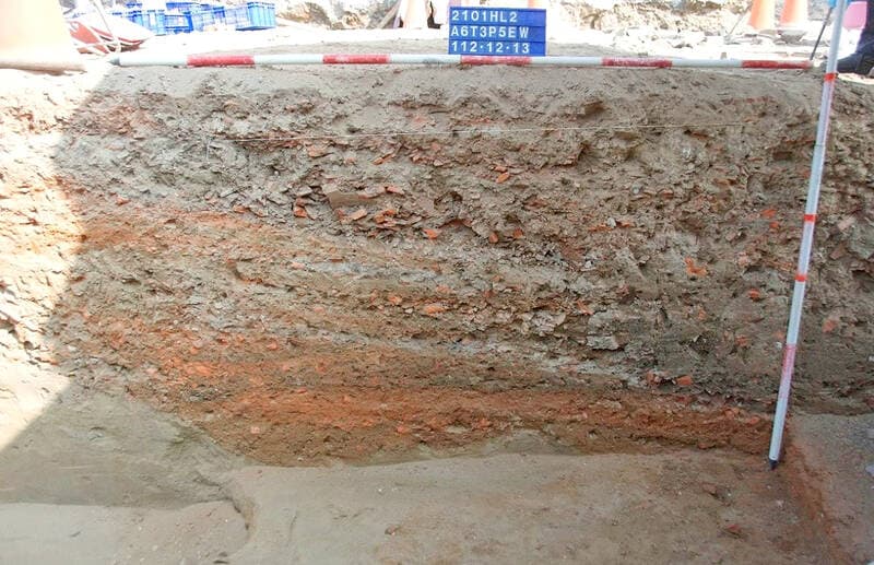
Archaeologists in Tainan have uncovered a set of 19th century roads with a curious ingredient in their construction. During work to move a section of the city’s railway underground, crews discovered road foundations beneath the area around Sin Lau Hospital on Dongmen Road in the East District. The Tainan Municipal Administration of Cultural Heritage said the remains appear to be parts of important thoroughfares from the first half of the 1800s, when Taiwan was administered as a prefecture of Fujian under the Qing Dynasty.
- A rare window into Tainan’s sugar streets
- How was sugar used in a road
- Dating the find and the Bullock Cart Road
- Tainan and the long arc of the sugar economy
- Archaeology during urban construction in Taiwan
- What happens next at the site
- How do archaeologists identify sugar in old roadbeds
- Why this discovery matters for residents
- Key Points
The roadbeds were built of mixed mud mortar, with the gaps between stones and compacted layers filled by a blend of mortar, fragments of broken ceramic and tile, and pieces of sugar. The combination suggests pragmatic road building that drew on materials that road workers could collect easily and cheaply in a district known for sugar production. After comparing the site with an 1875 map of Tainan, researchers believe the alignment matches the Bullock Cart Road that once served the area. Based on historical context and the cartography, the team concluded construction or renovation likely occurred around 1836 during the reign of Emperor Daoguang.
The find connects a modern infrastructure project with a period when sugar shaped Tainan’s economy and daily life. A Qing era travel account records sugar scattered so widely in the district that it even scented the streets on hot summer days. That depiction aligns with archaeologists’ view that sugar was available in such quantity that road crews mixed it into filler along with tile and pottery shards. The cultural heritage administration says the team has documented the location and temporarily relocated the materials so the railway can proceed with its underground alignment. Plans call for the remains to be presented later within a new parkway cultural project so residents can see how a sweet commodity once seeped into the fabric of the city.
How was sugar used in a road
The structure of the find reads like a handbook of practical road work before modern asphalt. The base is mud mortar, a compacted earth mixture that could be stabilized with natural binders and topped with successive layers. Workers then packed crevices with a blend of mortar and small hard fragments, including broken ceramics and roof tiles. That approach created a tougher surface, since shards of fired clay resist wear and improve drainage by opening tiny channels for water to escape.
Sugar appears in the mix as well, not as a surface layer, but as part of the fill wedged into gaps. The likely explanation is logistical rather than decorative. In an area that processed and traded sugar in bulk, workers could use sugar fragments as readily as they used other small, dense pieces at hand. The practice fits a pattern seen in many historical roadbeds, where builders reused local waste and byproducts to bind and stabilize surfaces.
A Qing official chronicle described how the heat of summer could draw out the sweetness from the very streets of this sugar district. The account captures the scene with unusual sensory detail.
During one summer, steam rose from the roads. It reacted with sugar mixed into the road and with sugar scattered nearby, and the air filled with a sweet aroma.
The image of a street perfumed by sugar helps explain why archaeologists keep encountering sugar residues in the crevices of this road foundation. It also hints at how frequently sugar would have been spilled, crushed, and compacted into the everyday infrastructure of the city.
Dating the find and the Bullock Cart Road
Two lines of evidence point toward the 1830s. First, the alignment and location match a path identified on an 1875 city map as the Bullock Cart Road. Second, the material culture and city growth at that time fit an era when Tainan remained a regional hub for agricultural commerce. The Daoguang period (1820 to 1850) saw steady movement of goods by animal drawn transport in and out of the city, and a road built or refurbished around 1836 would have served that traffic.
The name Bullock Cart Road suggests heavy carts loaded with sugarcane, processed sugar, ceramics, and other goods moving to warehouses and toward the ports in the Tainan area. Bullock carts were slow yet dependable, and roads built for them favored sturdy surfaces and ready repairs. Broken pottery and tile were common inputs in repairs, since local kilns and households produced a steady supply of fragments. Sugar, abundant in this district, likely entered the roadbed in the same piecemeal fashion. The uneven texture of mud mortar combined with shards and sugar pieces would have created a firm yet workable surface that could be patched quickly.
Tainan and the long arc of the sugar economy
Sugar shaped Tainan across centuries. In the Qing era, farmers cultivated cane on the plains surrounding the city. Small mills and boiling houses turned cane into crystalline sugar, syrup, and molasses. Coastal trade moved that output to regional markets. Historical accounts describe streets and storage yards busy with workers, carts, and sacks, a constant flow that made sugar part of both the economy and the environment.
Decades later, under Japanese rule, sugar production scaled up with industrial factories and private railways built for cane transport. Historic surveys cite more than forty factories and an extensive web of sugar rail lines that connected fields to mills and ports. Tainan’s Yongkang district, for example, became home to a major factory complex with its own narrow rail lines, housing, and community spaces. The new regime standardized production and export, yet it relied on pathways and labor patterns that had roots in the previous century. The newly uncovered roadbeds belong to that earlier layer of infrastructure, showing how local materials and practical know how shaped the ground even before industrial expansion.
The continuity is important. It links a handcrafted road, reinforced by pottery shards and sugar fragments, to a city that later industrialized sugar with factories and dedicated rail. The dig offers a tangible reminder that the large sugar networks of the 20th century grew on top of 19th century roads and cart paths. It also hints at a culture of reuse and resourcefulness, where broken tiles and sugar remnants became building materials instead of waste.
Archaeology during urban construction in Taiwan
Modern infrastructure projects in Taiwan frequently reveal traces of earlier settlements and industries. Salvage archaeology, sometimes called rescue archaeology, is the standard response when work crews encounter ruins in a construction zone. Teams map what they find, collect samples, and document layers in a compressed time window so projects can proceed.
Tainan has seen this dynamic repeatedly. Excavation for the Southern Taiwan Science Park uncovered dozens of sites across a wide area. Investigations there helped scholars piece together ancient settlement patterns and foodways, including the spread of rice and millet cultivation. Researchers refined techniques such as soil flotation to recover seeds and micro remains, yielding insights that routine digs often missed.
Preservation law provides a framework, notably the Cultural Heritage Preservation Act, but enforcement competes with schedules and budgets. Salvage digs protect knowledge by recording it, yet they can be rushed if deadlines loom. The newly discovered roads beneath Dongmen Road stand as a case where rescue work is paired with a plan for public display. The cultural heritage administration says the team finished documentation and moved the materials for safe keeping so the railway can move underground. City planners intend to return the finds for interpretation within a new parkway once construction is complete.
What happens next at the site
After documenting layers, photographing alignments, and recording the mix of mortar, pottery, tile, and sugar, the team removed sections of the road foundation so heavy equipment can continue underground rail work. Temporary relocation is common when a site cannot remain in place during major construction. The goal is to keep the material safe and intact for later study and presentation.
Plans call for the remains to be incorporated into a parkway cultural project after the railway is complete. That approach typically means a landscaped corridor with preserved features either displayed in situ or reassembled nearby, along with interpretive panels explaining how the roads were built, what materials were used, and why the site matters to Tainan’s history. The exhibit can showcase both the roadbed and the sugar industry context, including the logistics of bullock cart transport and the reuse of ceramics and tiles from homes and kilns. The aroma described in the Qing era chronicle may even inspire creative interpretation for visitors, though any recreated scent would need to be clearly labeled as an educational device rather than a surviving feature.
How do archaeologists identify sugar in old roadbeds
Sugar dissolves in water, so its survival inside a road might seem puzzling. Several factors can preserve sugar residues in the ground for long periods. Pieces can become embedded and sealed within mortar or compacted earth where water infiltration is limited. If the fragment sits within a protected pocket, exposure to flowing water is reduced. Crystallized sugar can also recrystallize after partial dissolution if moisture is intermittent and the surrounding matrix dries. Over time, this can leave detectable sugar residues trapped in the road fabric.
To confirm the presence of sugar, analysts can turn to a toolkit used for organic residue identification. Microscopy comes first, to locate and document crystals or globules within the matrix. Chemical spot tests can screen for carbohydrates, while laboratory methods such as high performance liquid chromatography or mass spectrometry can detect sucrose and its breakdown products, glucose and fructose. Stable isotope analysis can sometimes distinguish cane sugar from other plant sources, since cane and many grasses share similar carbon signatures, but this requires careful sampling and controls. Infrared spectroscopy can help identify functional groups associated with carbohydrates in mineralized contexts. Taken together, these methods allow researchers to say with confidence whether the granular material in the crevices is sugar or another organic filler.
The presence of sugar in a road also helps interpret worksite behavior. Broken tile and pottery fragments came from household refuse and kiln waste. Sugar probably came from spillage during transport or from waste generated by processing. Road crews working quickly with local materials would have used whatever small, angular particles were on hand to wedge into gaps and firm up the surface. Confirmation of sugar in the matrix, alongside ceramic and tile shards, cements the link to a district where sugar production and trade dominated daily life.
Why this discovery matters for residents
The find adds more than a curious detail about historical construction. It reveals how economic life imprinted itself on the city’s physical fabric. Sugar did not stay confined to warehouses or ledgers. It literally filled the cracks in roads. That story turns a major rail project into an opportunity for people to see, up close, how work and trade shaped their streets two centuries ago.
The planned parkway display can create a clear thread from the Qing era to the present. Visitors can learn how a road was made before modern asphalt, why ceramic fragments were useful, and how a single commodity could influence building choices. The exhibit can also highlight the role of salvage archaeology in busy cities, explaining how careful documentation and temporary relocation reconcile construction timelines with the need to protect heritage. Community programs and school visits can bring younger audiences into contact with the material culture of their city, grounding lessons in a site they can stand on and see.
Tainan’s identity has long been tied to trade, religion, and craftsmanship. The railway dig shows how an industrial past persists underfoot. The sweet smell recalled in a Qing era text is more than a poetic image. It is a clue to a working landscape where sugar moved in such quantities that it changed the roads themselves. Revealing that layer, then integrating it into a public space, keeps the city’s memory visible while the railway works move forward below.
Key Points
- Road foundations with sugar fragments, broken ceramics, and tiles were uncovered near Sin Lau Hospital on Dongmen Road in Tainan’s East District.
- Archaeologists date the roads to the first half of the 19th century, likely around 1836 during the Daoguang reign.
- The alignment matches a path marked on an 1875 map as the Bullock Cart Road serving the area.
- Tainan’s cultural heritage administration documented the site and temporarily relocated materials to allow the railway to move underground.
- The remains are slated for inclusion in a parkway cultural project that will interpret Qing era road building and the local sugar economy.
- The discovery reflects how workers reused readily available materials from a major sugar making district.
- The case illustrates salvage archaeology in Taiwan, where construction often reveals heritage that is recorded and later presented to the public.