A fragile mountain range under intense pressure
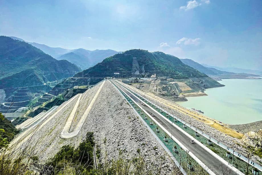
Hydropower is racing ahead in India’s Himalayas, from the towering Tehri dam in Uttarakhand to tunnels and highways cut through high mountain passes. The promise is clean electricity and secure transport links. The reality on the ground is more complicated. Sinking towns, collapsing slopes, damaged rivers, and deadly flood cascades point to a fragile mountain arc straining under rapid construction and a changing climate.
- A fragile mountain range under intense pressure
- Why hydropower climbs the Himalayas
- When mountains move, projects break
- Joshimath, Zoji La, and the cost of blasting
- Rivers changed, ecosystems strained
- Disasters are cascading faster in a warming climate
- Communities count the costs and the benefits
- Courts and rules, a shifting policy landscape
- The China factor and a race on the Brahmaputra
- What a safer energy plan could look like
- Key Points
Uttarakhand is often called India’s energy state. Steep gradients and fast rivers make turbines spin with ease. Farther north, the Zoji La corridor in Ladakh is a strategic lifeline to the high plateau. A new tunnel, billed as one of Asia’s longest, is designed to keep military traffic moving year round. Building it requires blasting and deep excavation in rock that is young and fractured. Residents and wildlife share that terrain, and both are sensitive to noise, vibration, and dust.
Warnings have piled up. In early 2021, an avalanche and outburst flood roared down a valley in Uttarakhand, wrecking two hydro projects and killing more than 200 workers and residents. In October 2023, a glacial lake in Sikkim burst and sent a wall of water and debris down the Teesta river valley, destroying hydropower stations and bridges. These incidents are windows into how infrastructure interacts with hazards that are growing as temperatures rise.
At the same time, the market and policy push is strong. India plans 500 gigawatts of renewable capacity by 2030, and water power is seen as a flexible partner to wind and solar. The Central Electricity Authority lists close to 100 hydro schemes in the pipeline nationwide, including dozens already under construction. Many are in the Himalayas, where the ground is most unstable.
In the town of Joshimath, a gateway to several Himalayan shrines, land subsidence forced families from more than 800 homes and cracked roads and temples. Local groups and scientists have linked the crisis to heavy construction, including tunneling and blasting for a nearby hydropower project. Government agencies disagree over the causes. The outcomes are visible in the walls that split and the neighborhoods emptied.
Why hydropower climbs the Himalayas
Hydropower provides roughly 14 percent of India’s installed power capacity. It can ramp up and down quickly, which helps smooth the spikes and lulls from solar and wind. The Himalayas appear ideal at first glance, with high drops and abundant snow and ice that feed swift rivers. Policy support is generous, and since 2019 large hydro has been categorized as renewable for certain incentives. The result is a steady flow of new proposals, many stacked one after another in the same valleys.
What makes the Himalayas look ideal
Hydropower plants turn falling water into electricity. The steeper the drop, the more power per liter. Mountain catchments bring that drop. Monsoon rains and snowmelt push peak flows for part of the year, and reservoirs or diversions channel energy to turbines. For grid planners that flexibility is attractive, especially as India adds large amounts of solar on the plains and wind along coasts and ridges.
Run of the river is not impact free
Many Himalayan schemes use run of the river designs, which avoid large reservoirs and are often described as low impact. In practice, these projects divert most of the river through tunnels for many kilometers, then release it back near the powerhouse. Long dry stretches can follow, which hurts aquatic life and downstream users. Road building, muck dumping, and blasting can destabilize slopes. Even without big reservoirs, these projects need access roads, adits, powerhouses, and transmission corridors that bite into fragile hillsides. People in valleys often report cracked homes, damaged springs, and fields short of irrigation water after tunneling begins.
States are doubling down. Himachal Pradesh already has more than 10,000 megawatts in place and plans to increase capacity, despite almost the entire state being prone to landslides. The Central Electricity Authority counts 98 hydro projects totaling over 58,000 megawatts in the national pipeline, with 36 under construction. That scale magnifies cumulative effects in narrow valleys.
When mountains move, projects break
The Himalayas are among the youngest mountain ranges on Earth. Rock layers are fractured and still rising. Earthquakes, landslides, and flash floods are common. When heavy construction and blasting shake an already unstable slope, the odds of failure increase. Reservoirs can alter stress along faults and add weight on slopes. Intense monsoon bursts saturate loose debris. More warming means more melt and more rain falling in short, violent spells.
Experience shows how quickly disasters can wipe out infrastructure. After the 2015 Nepal earthquake, sediment and landslides took out many hydropower sites across steep valleys. Geologist Wolfgang Schwanghart of the University of Potsdam was struck by what he saw during fieldwork in the region. He said:
They looked rather precarious.
Risk also comes from above. As glaciers retreat, lakes form behind loose moraine walls. When a chunk of rock or ice falls in, the wave can overtop the dam and trigger a devastating outburst. Cascades of hydropower stations placed one below another mean that a breach upriver can wrench through the entire chain, with no time for operators to react. Even projects designed for flood control can face sudden inflows beyond their assumptions.
Joshimath, Zoji La, and the cost of blasting
Joshimath became a national alarm bell in early 2023 when ground subsidence opened deep cracks in homes and streets. Residents pointed to tunneling and blasting linked to nearby hydro works, along with slope cutting for highways. Satellite imagery showed rapid sinking in parts of the town. Officials debated the causes, yet the immediate fact was clear. A sacred gateway town was no longer safe for many of its families.
Across the high passes in Ladakh, the Zoji La tunnel promises year round access between the Kashmir Valley and the Ladakh plateau. It is a strategic project, vital for defense and for civil supplies. The construction method depends on heavy blasting and excavation within a tight, snow bound corridor. Local voices warn that such work disturbs fragile geology and wildlife in the Trans Himalayan landscape. Once a tunnel opens, the traffic it enables often sparks more building and more slope cutting. The carrying capacity of the mountains rarely figures in those chain reactions.
Rivers changed, ecosystems strained
Dams and diversions alter how a river lives. They change flow timing, temperature, and sediment transport. In the western Himalayas, scientists who compared reaches above and below hydro diversions found that stretches left dry or with low flows lose species richness and density in riparian vegetation. The same research observed more resilient structures where water was released back, underscoring how key environmental flow rules are for plants and the animals that depend on them. Springs can shift or dry up after tunneling, and with them the household and farm water that villages rely on.
For river communities, the changes are personal. In Uttarakhand’s Bhilangana basin, farmers described channels that once ran full now reduced to a trickle for long distances when water is routed into tunnels. One elderly cultivator put it plainly:
The hydropower project has taken all the water.
Water is not only for crops. Rituals, cremations, and religious gatherings need flowing rivers. Operators sometimes open gates for ceremonies, yet in lean months even that release can fall short. Dry riverbeds mean fish collapse, and with it small fisheries and mills. Environmental flow rules on paper do not always match conditions on the ground.
Disasters are cascading faster in a warming climate
On 3 October 2023, about 14.7 million cubic meters of frozen moraine material slumped into South Lhonak Lake in Sikkim. The impact wave rose tens of meters, breached the moraine wall, and released roughly 50 million cubic meters of water. The flood ran down the Teesta valley, tearing out bridges, scouring slopes, and destroying at least five hydropower stations. Researchers from several countries reconstructed the sequence with satellite images and seismic records. They also mapped a huge pulse of sediment, around 270 million cubic meters, carried downstream.
At least 55 people died and many were reported missing. The numbers are grim, yet the pattern is the real warning. More warming means more unstable ice, rock, and permafrost. Lakes enlarge, slopes loosen, and rainfall extremes intensify. Hydropower infrastructure placed in narrow valleys stands directly in the path of these cascades. Early warning networks, lake monitoring, and coordinated emergency rules can reduce losses, but projects built in the highest risk corridors will face repeated hits.
Communities count the costs and the benefits
Hydropower companies often highlight roads, compensation, and local funds as benefits. Many villages do see better road access, which helps connect markets and emergency services. Some households receive payments for land. Jobs arise during construction, though permanent roles are few. Transmission lines usually send most of the power out to the national grid, not to the hamlets that live next to the dams. Meanwhile, loss of irrigation, spring shifts, cracked homes, and landslides carry heavy costs that compensation rarely covers for long.
The economics are not simple for developers either. Geological surprises, protests, and weather delays can drag projects for years. Equipment has to be hauled over long, difficult routes. When dry season flows shrink, output drops. In some basins, plants can run at a small fraction of capacity outside the monsoon, then take a thrashing during the wet months. Financing that looked solid on paper can sour once repairs, slope stabilization, and insurance are added in.
Courts and rules, a shifting policy landscape
India’s courts have wrestled for a decade with how to balance energy plans and safety in the Himalayas. After the Kedarnath floods in 2013, a court appointed expert body concluded that hydropower projects had worsened disaster impacts and advised canceling several planned schemes. Subsequent committees and ministries revisited those findings again and again, often in conflicting ways. The back and forth left valley after valley in limbo, with construction paused and then resumed.
In 2025, the Supreme Court, hearing a case on ecological damage in Himachal Pradesh, described the Himalayan region as facing an existential crisis. The bench pointed to human actions that turn hazards into catastrophes. In a stark observation, the judges said:
Humans, not nature, are responsible for continuous landslides, collapse of buildings, and road subsidence.
The court asked the state to detail climate plans, disaster funding, and the status of hydropower and roads. That scrutiny puts agencies on notice that policies, not only rainfall and earthquakes, shape outcomes. It also widens the debate to include zoning, forest cover, and the carrying capacity of mountain towns that are expanding fast.
The China factor and a race on the Brahmaputra
Upstream of India, China has approved a massive project on the lower Yarlung Tsangpo, at a location known as the Great Bend. The plan envisions electricity output several times larger than the Three Gorges Dam. India has discussed its own large project on the Siang, the main tributary of the Brahmaputra. In a tense border zone, dams become instruments of policy as well as energy. Without robust data sharing and joint monitoring, mistrust grows, and so does pressure to build quickly in difficult terrain.
Big river engineering at that scale can alter sediment flows, disrupt ecosystems downstream, and heighten risks in quakes. It can also embed rivalries into river basins that cross three countries. Transparent hydrological data, early flood warnings, and basin wide planning are essential. So is shifting more of the region’s clean energy growth to lower risk places, like the Deccan plateau for solar and wind, rather than stacking more concrete in the most fragile mountain gorges.
What a safer energy plan could look like
Making the Himalayas safer is not about ending all projects overnight. It is about matching energy planning with the reality of unstable geology, extreme weather, and local needs. Several practical steps would reduce risk while keeping India’s clean energy targets on track.
Reduce exposure and get the basics right
Set strict no build zones in corridors with high landslide density, active faults, or clusters of glacial lakes. Require cumulative impact assessments for cascades along entire rivers, not one project at a time. Enforce environmental flow releases that reflect seasonal ecology, and monitor them with open data. Strengthen muck disposal rules, with lined, engineered sites and independent audits. Mandate comprehensive geotechnical monitoring of tunnels and slopes during and after construction.
Shift capacity to safer geographies
Move more renewable growth to lower risk areas. Expand utility scale solar in the plains, rooftop solar in cities, and wind in suitable zones. Build grid scale battery storage and pumped storage outside fragile catchments to provide balancing power. Where small hydropower exists, upgrade with fish passages, sediment bypasses, and smarter flow management rather than adding new diversions in sensitive valleys.
Plan for the climate that is coming, not the one that passed
Use high resolution climate projections for design floods and seismic scenarios. Install early warning systems for cloudbursts and glacial lake outbursts in all at risk valleys, with sirens, automated gates, and clear evacuation maps. Fund continuous monitoring of dangerous lakes and thawing permafrost. Design emergency drawdown and fail safe protocols for reservoirs that do exist, and practice joint drills across districts.
Put local communities at the center
Require free, prior, and informed consent for major works. Build benefit sharing into tariffs, so money flows back to upstream communities in a reliable way. Prioritize local jobs beyond construction, including monitoring, maintenance, and ecological restoration. Keep cultural needs in view. Rivers in the Himalayas are both lifelines and sacred. Planning should respect that reality.
Key Points
- India is pushing new hydropower in the Himalayas to help balance rising solar and wind, yet many valleys are geologically unstable.
- Joshimath’s subsidence and the Zoji La tunnel highlight the risks from blasting, tunneling, and road cutting in fragile terrain.
- The 2021 Uttarakhand disaster and the 2023 Sikkim glacial lake outburst flood destroyed multiple hydro plants and caused heavy loss of life.
- Studies in the western Himalayas show diverted river stretches lose riparian species richness and density without strong environmental flows.
- The Central Electricity Authority lists 98 hydropower projects in the national pipeline, including 36 under construction, many in hazard prone areas.
- The Supreme Court has warned of an existential crisis in the Himalayas and faulted human activities for landslides and subsidence.
- China’s mega dam plan on the Yarlung Tsangpo and India’s response on the Siang risk a transboundary race with ecological fallout.
- Safer options include moving more capacity to solar and wind outside fragile catchments, adding storage, enforcing no build zones, and improving early warning systems.
- Local communities report water scarcity, cracked homes, and limited long term employment near projects, while many benefits flow out via the grid.
- Adopting cumulative impact assessments, robust environmental flows, and open monitoring can lower risks while meeting energy goals.