A warmer October, then a sudden chill
Japan is heading into a short autumn that feels late to arrive, then winter is set to come on fast. The Japan Meteorological Agency (JMA) expects October to run warmer than average across the country after the hottest summer on record, with some early October days still reaching around 30 degrees Celsius in parts of Honshu. Forecasters warn that the warmth will linger through mid November, then cold air will strengthen in late November and bring a sharp drop in temperatures. December is projected to be near or below normal in eastern and western Japan, as well as in Okinawa and Amami, while northern Japan skews closer to normal.
- A warmer October, then a sudden chill
- What the forecast says through December
- The climate drivers behind the flip
- Autumn leaves may reach peak later, then turn fast
- Travel and health tips for a split season
- Energy, agriculture, and city services on alert
- How to prepare for a fast swing in temperatures
- What to Know
The agency links the unusual staggered pattern to two forces acting together. A steadily warming climate has pushed seasonal baselines higher. At the same time, La Niña like cooling in the equatorial central and eastern Pacific has nudged the jet stream north of Japan, letting warm air dominate for longer in autumn. When the seasonal wind pattern over Siberia intensifies late in the fall, that same setup allows colder air to surge south quickly. The JMA expects the October to December period to average near normal nationwide by the end of the quarter, even with a late plunge.
Yoshinori Oikawa, who directs the JMA Tokyo Climate Center, cautioned the public to manage both heat and sudden cold during the transition. He noted that people should continue heatstroke prevention in early October because some days will still feel like midsummer, then prepare for a quick flip in late November. Introducing the outlook, he underlined the abrupt nature of the change.
“It will feel like an abrupt seasonal shift. Please take care of your health,” said Yoshinori Oikawa, director of the JMA Tokyo Climate Center.
What the forecast says through December
October: Temperatures are likely to run above average across the archipelago. Early October can still bring summer like afternoons in many cities, particularly in Kanto, Tokai, and Kansai. The JMA also flags an increased chance of heavier rainfall episodes in October for western Japan and along the Pacific side of eastern Japan. Heat stress remains a risk on the warmest days, especially in urban heat islands and for outdoor workers, students in sports, and older adults.
November: The first half of the month remains relatively mild. From the second half, colder air masses strengthen and push south, flipping many locations from shirtsleeves to coats in a span of days. That kind of quick change can aggravate respiratory conditions and strain energy demand as heaters come on early. Travelers and event organizers should add flexibility for late month cold outbreaks, particularly in the Hokuriku and Tohoku regions where early snow showers are possible at elevation.
December: Eastern and western Japan, along with Okinawa and Amami, trend near or below normal for temperatures. Northern Japan hovers closer to normal. On the Sea of Japan side, snowfall is expected to be average to above average in parts of western Japan, with roughly average snowfall in eastern and northern Japan. For the broader winter period of December through February, JMA guidance points to temperatures near normal nationwide.
The climate drivers behind the flip
Two climate influences can explain why autumn is stretched warm and winter’s arrival looks abrupt. First, background warming from human caused climate change has lifted average temperatures and made hot extremes more frequent in Japan. After the record summer, soils, rivers, and cities have stored heat that bleeds into October. Second, La Niña like cooling in the equatorial central and eastern Pacific affects the wind patterns over the North Pacific. When waters in that region run cooler than average, the jet stream often shifts north near Japan during autumn. A north shifted jet suppresses frequent cold fronts and lets warm air linger across much of Honshu and Shikoku, delaying the feel of autumn.
Into late November, as the Siberian High builds and the East Asian winter monsoon gains strength, cold air outbreaks can undercut that warm pattern. The result is a fast swing rather than a gradual slide. JMA assessments this year note that the equatorial Pacific shows cooler than average sea surface temperatures, but full ocean and atmosphere coupling may weaken later in winter. This aligns with outlooks that favor mostly neutral conditions for the peak of winter, even if brief La Niña like signals show up in late autumn. That combination supports a late flip to colder weather, then a mid winter return to closer to normal conditions.
Why the jet stream matters
The jet stream is a narrow, fast river of air circling the hemisphere at high altitude. Its position steers storms and separates warm from cold air. When it bows north of Japan in autumn, warm, stable weather lasts longer and cold fronts tend to skid by to the north. If the jet dips south later, or splits and weakens as the monsoon strengthens, cold surges can pour into the Sea of Japan side. These surges pick up moisture over the warm sea and dump snow on windward mountains, while the Pacific side often stays sunnier and drier.
What La Niña means for Japan
La Niña is the cool phase of the El Niño Southern Oscillation. In East Asia, La Niña winters often strengthen the winter monsoon that carries cold, dry air out of Siberia. When that air crosses the Sea of Japan, it gathers moisture and releases it as heavy snow on the Hokuriku, Tohoku, and Hokkaido coasts and ranges. This year, JMA and other agencies have highlighted that neutral conditions still look more likely for winter as a whole, with a chance that La Niña like patterns appear during late autumn into early winter. That helps explain the expectation of a late month flip in November and a colder turn in December for many regions, without a guarantee of a persistently cold season after New Year.
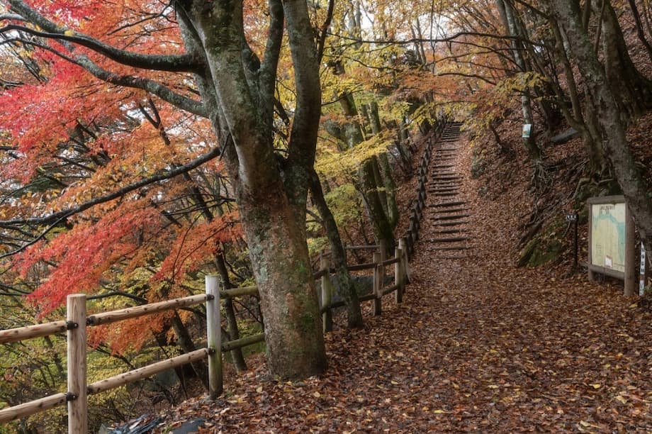
Autumn leaves may reach peak later, then turn fast
Warm starts to autumn tend to delay the color change of deciduous trees. Japan’s famous koyo season usually begins in Hokkaido by mid September, moves through the Tohoku highlands in early to mid October, reaches the Japanese Alps and Chubu in early to mid November, and peaks across Kanto and Kansai from late November into early December. Southern Kyushu can hold color into December. Local elevation and microclimates still drive wide variation, and urban heat can push peak dates later in big cities.
In recent warm years, several cities have seen very late peaks. Tokyo has matched its latest red foliage peak near December 5, and Osaka has peaked around December 8. Kyoto has in some seasons held best color into mid December. A warm October this year makes a later than usual start more likely in lowland Kanto and Kansai. Once colder air arrives in late November, color can deepen quickly, but the window to view peak leaves may shorten if a sharp cold snap or wind event accelerates leaf drop.
For travelers, flexibility is the best strategy. High elevation destinations like Daisetsuzan National Park in Hokkaido, the Tateyama Kurobe Alpine Route, and Nikko near Tochigi turn earlier. Urban favorites such as Tokyo’s Rikugien and Meiji Jingu Gaien Ginkgo Avenue, or Kyoto’s Arashiyama, Nanzen ji, and Kiyomizu dera, usually shine later. Check local forecasts and live cameras, and plan backup sites at different elevations to hedge against a short peak.
Travel and health tips for a split season
Early October can still feel like summer in parts of Japan. Hydration, shade breaks, and sunscreen remain smart choices for outdoor festivals, sports days, or long walks through parks. Visitors should expect air conditioned interiors and warm sunshine outside, which can cause dehydration without noticing. Coastal humidity also slows the body’s cooling.
By late November the script flips. Cold surges can arrive quickly, with mornings and nights turning wintry even if afternoons stay cool and sunny. Layering works best. A light outer shell with a sweater or down vest, gloves for mornings, and a scarf can cover a wide set of conditions. Mountain areas can swing below freezing once cold air settles, so hikers should bring traction gear, headlamps for short daylight, and a hard cutoff time to descend safely.
Rail and road travel cope well with early season snow in Japan, but local buses in snowy belts can face delays during heavy lake effect episodes. If renting a car in Hokuriku, Tohoku, or Hokkaido from late November, book vehicles with winter tires and check for road closures. For city breaks, winter illuminations and hot spring day trips become attractive as temperatures drop. Onsen towns like Ginzan, Zao, Kusatsu, and Noboribetsu offer warm baths and easy access by train or highway bus.
Energy, agriculture, and city services on alert
Large swings in temperature can stress energy systems. Prolonged warmth into November keeps cooling demand up in southern Japan, then a quick shift to heating raises load sharply in late month. Utilities and large buildings often plan maintenance for shoulder seasons, so operators may need to adjust schedules if demand peaks arrive earlier than expected. Households can reduce bill shock by sealing drafts, cleaning filters, and setting moderate thermostat targets.
Farmers face a compressed schedule. Harvest for rice and late season vegetables can run ahead or behind normal depending on local heat, then cold snaps risk frost damage to leafy greens and citrus. Orchard managers may need to watch for pests that thrive in extended warmth and manage fruit storage carefully once colder air arrives. Cold spells can benefit some crops by triggering dormancy, but a rapid change can also stress plants if soil moisture is low after a dry October. Regional agriculture advisories will update guidance as the pattern evolves.
City services prepare for two different sets of hazards in close succession. Early autumn downpours on the Pacific side can stress drainage and cause landslides on saturated slopes. Weeks later, the focus in Hokuriku and Tohoku shifts to snow removal, black ice alerts, and roof clearing in heavy snow towns. Public health agencies often see more asthma, influenza, and cardiovascular stress during sharp temperature swings, so vaccination campaigns and early season health messaging can help reduce pressure on clinics as winter begins.
How to prepare for a fast swing in temperatures
A few simple steps can help households, travelers, and businesses manage a warm October and a sudden turn to early winter.
- Keep heatstroke habits in early October: hydrate, rest in shade during midday, and use hats or umbrellas for sun.
- Build a layered wardrobe for late November: light shell, warm mid layer, hat, gloves, and a scarf for wind.
- Check regional forecasts twice weekly in November, paying attention to cold surge outlooks and sea effect snow advisories on the Sea of Japan side.
- If traveling for autumn leaves, pick two or three sites at different elevations and book refundable tickets when possible.
- Service home heating in October, bleed radiators, clean heat pump filters, and check weather stripping on doors and windows.
- Prepare cars for winter in snowy belts by late November: winter tires, deicer, scraper, and an emergency kit.
- For schools and sports, schedule heat breaks in early October and add a cold weather gear checklist by mid November.
- Stock a small home kit with masks, cold medicine, and fever reducers before clinics get busy in December.
- Plan commutes with buffer time during the first cold surge, when road ice and early snow can slow traffic.
- Follow municipal advisories for flood risk in October and snow safety later in the season.
What to Know
- JMA expects October warmth to linger, then a sharp drop in late November and a colder turn in December for many regions.
- Eastern and western Japan, plus Okinawa and Amami, are projected near or below normal in December. Northern Japan trends closer to normal.
- Heavy rain episodes in October are more likely in western Japan and along the Pacific side of eastern Japan.
- Sea of Japan snowfall is forecast to be average to above average in parts of western Japan, with roughly average snowfall in eastern and northern Japan.
- For December through February, winter temperatures are expected to be near normal nationwide.
- La Niña like cooling in the equatorial Pacific and background warming together help explain the late autumn warmth and quick winter onset.
- Autumn foliage in warm years tends to peak later in lowland cities. A late November cold surge can narrow the best viewing window.
- Heat precautions are still needed in early October. Layered clothing, car winter prep, and flexible travel plans are smart for late November and December.