What triggered the latest focus on Taiwan from space
On October 25, the first national Commemoration Day of Taiwan’s Restoration, a set of crisp satellite photographs of Taiwan appeared on Chinese social platforms. The images, published by the official account of the Jilin-1 satellite constellation, showed familiar places on the island with street grids and coastal infrastructure visible from orbit. Taipei City, Taipei Port, the Alishan mountain area, Sun Moon Lake, Hsinchu Science Park, and Cape Eluanbi were among the sites featured. Days later, the Chinese Embassy in Washington carried the message across borders on X with a post that began, “There is but one China in the world.” The spotlight on Taiwan from space moved quickly from a domestic commemoration to an international talking point.
- What triggered the latest focus on Taiwan from space
- What is the Jilin-1 constellation
- Why the timing matters
- Political reaction in Taiwan and Washington
- Why Hsinchu and other sites stood out
- Beyond images, mapping apps and daily tech
- What satellites can legally see, and what they cannot
- Reading the message behind the imagery
- Key Points
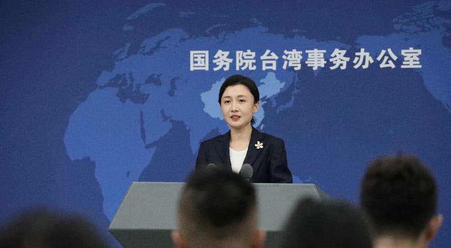
Beijing framed the space imagery as both a demonstration of technology and a symbol of political resolve. At a briefing in Beijing, Zhang Han, spokesperson for the State Council Taiwan Affairs Office, called Taiwan the motherland’s treasure island and linked advances in remote sensing to governance and security. Her comments captured the twin themes running through the release, national pride and a claim of administrative reach that extends across the strait.
Introducing her perspective, Zhang said the new wave of images reflected growing capabilities and confidence.
Zhang Han, spokesperson for the State Council Taiwan Affairs Office: “Taiwan is the motherland’s treasure island. As the mainland’s science and technology improve, we can measure our territory more accurately, guard our homeland more firmly, and embrace the future with greater resolve.”
For some viewers, the pictures were personal. A Taiwanese student who has lived on the mainland for nearly a decade described a rush of recognition when scrolling through the photos.
Wang Zexi, a student from Taiwan: “When pictures were zoomed in, I could even pinpoint the streets I used to frequent. It felt incredibly magical and thrilling.”
What is the Jilin-1 constellation
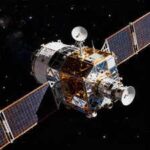
Jilin-1 is a large commercial Earth observation network built and operated by Chang Guang Satellite Technology, a company based in northeast China. The constellation has grown rapidly. Company data show 141 satellites in orbit supporting a mix of video, high resolution, infrared, and wide swath imaging. By coordinating many spacecraft flying in complementary orbits, the operator can revisit locations many times a day. The developer says the system can revisit global targets up to 40 times per day, offer global coverage multiple times a year, and image domestic targets on a routine cadence measured in weeks. These revisit rates are valuable because time series imagery lets analysts track change, from port activity to farmland health to disaster damage.
Remote sensing satellites collect reflected light in visible and infrared bands to map land, water, and man made features. Video units capture short clips that show movement, for example ships approaching a harbor. Wide swath units collect broader strips that are useful for mapping larger regions. The result is a layered system that can produce both detailed snapshots and wider situational views.
How sharp are the images
Resolution is a measure of the smallest objects a sensor can distinguish. In the Jilin-1 collection released for Taiwan, the company cited submeter resolution, which means features around half a meter to one meter across can be detected. At that level, roads, vehicles, piers, and rooftop shapes are visible, and the layout of a port or science park is straightforward to interpret. Faces and license plates cannot be read from this altitude with civilian systems, and weather and viewing angle can degrade clarity.
One of the program’s senior managers described the Taiwan tasking as routine for the fleet and outlined the precision the system can reach.
Jia Hongguang, vice general manager at Chang Guang Satellite Technology: “The images generally feature submeter resolution, meaning local street views and layouts can be precisely identified. It is an easy task for Jilin-1 to conduct comprehensive imaging of Taiwan.”
Company officials and regional media have touted even finer performance in the best cases. Executives have said that some units can reach a maximum resolution near twenty centimeters in ideal conditions at about five hundred kilometers altitude. At that scale, people can be counted in an open square, although identification of individuals is not feasible from orbit. The key takeaway is that modern commercial sensors, especially when used in constellations, can deliver sharp, frequent images of most places on Earth.
Why the timing matters
The release took place during a week of mainland events marking the 80th anniversary of Taiwan’s restoration, a reference to the October 1945 end of fifty years of Japanese colonial rule. For Beijing, the commemoration is meant to anchor a historical narrative that places Taiwan within a broader national story. Space images of Taiwan were presented as an affirmation of that narrative and a showcase of modern capability that did not exist when the historical milestone occurred.
The official Jilin-1 account paired the photos with an explicit statement of sovereignty. The language was clear and intended for audiences on both sides of the strait.
Official Jilin-1 account on WeChat: “Taiwan is an inalienable part of China and every inch of Taiwan Province is full of vitality from the space perspective of Jilin-1.”
Academic voices echoed the domestic framing that technology can shape public feeling as well as policy. A mainland scholar who studies Taiwan described how seeing places on the island in detail can shift perceptions among people who previously knew the island only from maps and schoolbooks.
Zhang Wensheng, deputy dean at the Taiwan Research Institute of Xiamen University: “With modern technology, we can see what is happening on Taiwan island, similar to how people in ancient times gazed at the moon to think of family. The images give the mainland public a more concrete sense of the treasured island, which can deepen emotional connection.”
Political reaction in Taiwan and Washington
Officials in Taipei and in Washington criticized the display. Taiwan’s representative office in the United States called the embassy’s post an example of creepy spying and contrasted the message attached to the images with a scientific focus the island plans for its own new satellite. The office pointed to the upcoming launch of Formosat 8 and stressed civilian goals.
Taiwan’s representative office in the United States: “Formosat 8, named after documentary filmmaker Chi Po-lin, will launch in mid November and provide ultra high resolution images from space. Its mission is for science and public service, not for spying or making fantasy claims.”
Taiwanese national security figures also pushed back on the political framing that accompanied the photos.
Joseph Wu, secretary general of Taiwan’s National Security Council: “It is Taiwan, not any part of the People’s Republic of China. The stalker pipe dreams need to stop here. China must learn to respect the will of the people, starting with Chinese people’s will to be free from autocracy.”
Members of the United States Congress weighed in as well. The chairman of the Senate Foreign Relations Committee described the embassy’s message as misrepresenting history and threatening a democracy.
Senator Jim Risch, chair of the U.S. Senate Foreign Relations Committee: “The People’s Republic of China has never controlled the territory of Taiwan, and this post is a great example of the Chinese Communist Party’s misrepresentation of history and blatant threats against a peaceful democracy.”
A community note attached by users on X added context, stating that Taiwan has never been part of the People’s Republic of China. The social media back and forth mirrored official exchanges and underscored how images from space can become instruments in political communication on the ground.
Why Hsinchu and other sites stood out
Among the locations highlighted, Hsinchu Science Park drew the most attention from industry watchers. The compact zone southwest of Taipei is home to Taiwan Semiconductor Manufacturing Company, United Microelectronics Corporation, MediaTek, and major government agencies that set policy for space and semiconductor development. Taiwan manufactures the vast majority of the world’s most advanced logic chips, and many estimates place the share above 90 percent for the most cutting edge processors used in data centers and phones. An image of Hsinchu from orbit serves as a reminder that a large share of global computing power depends on facilities located in a relatively small area.
Other sites have strategic value for geography and logistics. Taipei Port is a modern deep water terminal and logistics hub with direct road connections to the capital. Cape Eluanbi overlooks the Bashi Channel, a critical waterway linking the South China Sea and the Pacific. In any crisis, commercial and military planners alike would look at these locations for their roles in shipping, resupply, and movement.
The selection of sites reflects both the daily life of Taiwan and the places most relevant to technology and trade. The Taipei skyline and alpine forests of Alishan appear next to a deep water port and a chip campus. In combination, the set reads as a tour of the island’s civic, economic, and geographic core.
Beyond images, mapping apps and daily tech
Alongside the satellite release, social media users in the mainland discussed a separate tech development. AMap, also known as Gaode Map, appeared to be fully usable across Taiwan with navigation, traffic, and satellite layers. That generated anecdotes of people testing routes from mainland cities across the strait and finding Taiwan addresses inside app menus. Detailed mapping of Taiwan has existed on various platforms for years, but the apparent parity of features across the strait for a major mainland app drew fresh notice.
Asked about reports that AMap now works across Taiwan, a mainland spokesperson linked consumer technology and everyday convenience to shared interests in a better life.
Zhang Han, spokesperson for the State Council Taiwan Affairs Office: “The pursuit of a better and more convenient life is a right shared by compatriots on both sides of the strait. We welcome these developments and hope more Taiwan compatriots can enjoy high quality products and services from the mainland.”
Individual experiences reflect that trend. Payment apps, on demand delivery, and public transit information have become part of daily life in Chinese cities. Wang Zexi, the Taiwanese student living on the mainland, said he hopes friends and family in Taiwan can try some of these services soon because they make routines faster and easier.
What satellites can legally see, and what they cannot
Earth observation from orbit is governed by space law, not by the airspace rules that apply to aircraft. The 1967 Outer Space Treaty established that outer space is free for exploration and use by all states and that no nation can claim sovereignty over it. Satellite overflight is legal, and this applies equally to government and commercial systems. Countries can regulate how companies in their jurisdiction use and export data, but they cannot forbid satellites from other countries to pass overhead.
Modern commercial satellites can resolve cars, small boats, and building details. With submeter resolution, image interpreters can measure runway markings, see port cranes and container stacks, and count vehicles in parking lots. Weather, haze, and shadows often limit clarity. Even with very sharp sensors, reading a license plate or identifying a face is not possible from orbit with civilian systems, and any such claim should be viewed with skepticism. The practical power of these constellations comes from frequency. A network that collects many images per day can capture patterns over time, which is useful in agriculture, insurance, urban planning, disaster response, and security analysis.
That mix of uses is why observers call these systems dual use technology. The same image that helps firefighters map a wildfire perimeter can also help analysts measure activity at a missile base or a shipyard. China built Jilin-1 as a commercial network, although researchers in the United States and Europe have noted links between the operator and Chinese state priorities. The dual use nature is not unique to China. The largest Earth observation companies in the United States and Europe also serve both civilian and government customers.
Reading the message behind the imagery
The immediate message Beijing wanted to send was about capability and confidence. By pairing sharp pictures of Taiwan with political slogans and a commemoration, the mainland presented a narrative of unity and strength. Images can travel farther and faster than statements, and they can carry an air of impartiality because they look like raw scenes. Yet what a satellite shows, and when it shows it, is a choice. Here, the selection of landmarks and strategic sites suggested a domestic appeal to history and a foreign facing reminder that the mainland can see details across the strait whenever it wishes.
The release also lands in the middle of a period of sustained military pressure on Taiwan. Chinese military aircraft regularly cross the informal median line of the strait. The Eastern Theater Command has staged large drills that simulate air and sea blockades. In that environment, ultra frequent imaging by any party will be scrutinized for what it says about planning and readiness. Even when no classified information is revealed, the act of showcasing a clear image of a chip complex, a port, or a government district can send a signal.
At home, Chinese officials and scholars describe a softer effect. They say the photos help mainland residents form a more specific picture of Taiwan and its people. The idea is that seeing real places from above can shrink emotional distance even as politics remain tense. That argument has limits, as the reactions from Taipei and Washington show, but it captures how a single technology can carry very different meanings at once.
Key Points
- China’s Jilin-1 commercial satellite network released detailed images of Taiwan during events marking the 80th anniversary of Taiwan’s restoration on October 25.
- Beijing framed the release as proof of growing technical strength and as a political statement about sovereignty.
- A mainland spokesperson said advances in remote sensing bolster the ability to measure territory and safeguard the homeland, and invited more Taiwan compatriots to visit the mainland.
- The constellation includes 141 satellites and can revisit global targets many times a day, producing submeter imagery that shows streets, ports, and industrial sites.
- Taiwan’s representative office in the United States criticized the embassy’s post as creepy spying and promoted the upcoming Formosat 8 for science and public service.
- U.S. Senator Jim Risch and Taiwanese security officials rejected the embassy’s message, calling it a misrepresentation of history and a threat to a democracy.
- Images of Hsinchu Science Park highlighted Taiwan’s central role in advanced chipmaking, where a large share of the world’s most advanced logic chips are produced.
- Reports that AMap works across Taiwan added to discussion of cross strait technology and consumer services.
- Satellite overflight is legal under space law, and commercial imagery is widely used for agriculture, disaster response, urban planning, and security analysis.