Lives and livelihoods at the edge of the South China Sea
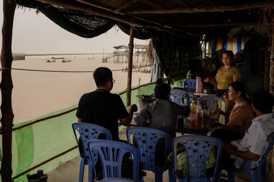
From the stilts of her small restaurant outside Vinh Chau, Danh watches the tide reveal fragments of a place that is no longer there. Tile from an old washroom appears for a moment, then slips back under the brown water. Blackened concrete lies scattered in the mud like bones. In August 2021, a spring tide tore through the village where she grew up and took nearly everything in a single night. The surf reached the road and the homes on either side. When the waters fell, there was little left to rebuild.
- Lives and livelihoods at the edge of the South China Sea
- What is pushing the delta down?
- Rising seas and saltwater are reshaping the coast
- The cost to food security and the economy
- Vietnam is rethinking how to live with water
- Water, sediment, and diplomacy
- People in motion and the human toll
- What success looks like in the next decade
- The Bottom Line
Danh, who rebuilt a modest eatery on higher stilts after the flood, still recalls the shock of that day and the long months that followed.
Everything was gone. The waves were very high. They reached all the way to the road. I lost everything that day.
Her loss is not an outlier. Vietnam’s Mekong Delta, a low plain of about 40,000 square kilometers where most land sits less than two meters above sea level, is being squeezed from two sides. The sea is rising and pushing salt inland. The land itself is sinking as people pump groundwater and as the river that once fed the delta with sediment arrives with far less sand and silt. Nearly 20 million residents and a vital share of Vietnam’s food production sit in this fragile zone. Projections warn that large tracts could be underwater by century’s end. Estimates widely cited by development agencies indicate that about 40 percent of the delta could be submerged by 2100 and that more than half of its people could be directly affected if current trends continue.
What is pushing the delta down?
River deltas are built by sediment carried from upstream and spread across wetlands and floodplains. The Mekong has done exactly that for millennia. Today the equation has changed. The ground surface is compacting faster, sediment inputs have fallen, and seas are creeping higher. The result is a net loss of elevation and growing exposure to tides and storm surges.
Groundwater extraction and subsidence
Across the delta, wells supply water for cities, farms, and shrimp ponds. Drawing large volumes of water from deep, soft layers compresses the sediments and causes the land surface to drop. International assessments estimate that the delta is sinking on average by about 1.1 centimeters per year. In heavily tapped zones, researchers have documented rates that are two to three centimeters per year. That means a canal bank, a road, or a home built at one height a decade ago can stand many centimeters lower relative to the tide today. Because the sinking is driven by human activity, it can accelerate where pumping expands and slow where supplies are switched to cleaner surface water or piped alternatives.
The missing sediment that builds land
Sediment is the raw material of a delta. Upstream hydropower dams trap sand and silt. Inside the delta, intense sand mining for construction deepens river channels. Together, these forces rob the river of the material it needs to replenish banks and mudflats. Analyses by conservation groups and academic teams show that some riverbeds in the lower Mekong have been incising by 200 to 300 millimeters per year. Tides now penetrate farther inland and grow taller within the river network. Salinity in certain channels has doubled in about 15 years. High dikes designed to keep fields dry for multiple rice crops also keep floodwaters from spreading over the land, which means fewer nutrients and less sediment reach farm soils.
Matt Kondolf, a professor of landscape architecture and environmental planning at the University of California, Berkeley, warned about the scale of the risk when he and colleagues assessed the delta’s outlook in a major scientific review.
It is hard to fathom that a landform the size of the Netherlands and with a comparable population might disappear by the end of the century.
Sediment, water, and elevation are linked. If the river cannot raise the surface with fresh deposits, and if the ground continues to compact, the delta becomes lower in relation to the sea. That shift magnifies every storm surge, every high tide, and every dry season push of salt inland.
Rising seas and saltwater are reshaping the coast
Global sea level is rising by about three millimeters a year and can be higher in regional settings because of land subsidence and local ocean dynamics. For the Mekong Delta, the change is expressed in unpredictable coastal erosion, stronger tidal reach, and deeper saline intrusion. In some exposed reaches without natural protection, observers have measured the sea eating into the shoreline by tens of meters a year. A string of harsh dry seasons has amplified the stress. The 2016 drought was described as the worst in nearly a century, a warning of what longer and hotter dry spells can do when river flows are low and reservoirs upstream hold back water.
Salt carried by rising tides is now a defining force on farms and in villages far from the coast. Canals that once brought fresh water to rice fields have turned brackish for long stretches of the dry season. Orchards fail when salty groundwater reaches roots. Fish cages and shrimp ponds become harder to manage as salinity swings faster between seasons.
How salt changes farms and food
The delta produces about half of Vietnam’s rice and a large share of its aquaculture and fruit. In salt stricken tracts during severe episodes, assessments have recorded devastating harvest losses, with most rice plots injured by salinity and many fields failing entirely. Climate modeling in the central city of Can Tho, a core rice area, projects that rising temperatures and shifting rainfall could depress rice yields across all three growing seasons by mid century if farmers cannot adapt. One detailed study using crop simulation found average declines in the range of about 5.5 to 8.5 percent for Can Tho when potential carbon dioxide fertilization benefits were excluded. Extra irrigation and fertilizer alone did not offset the projected losses. The study noted that any gains from carbon dioxide fertilization are uncertain in real farm conditions and can be undermined by other stressors, including ozone and heat waves.
Salt intrusion also changes what farmers can grow. In the Ca Mau peninsula and other coastal districts, many households are replacing a third rice crop with aquaculture during the wet season, then returning to crops on soils enriched by flood silt. Where mangroves are restored along pond edges, shrimp fetch premium prices and the trees help buffer waves. These shifts do not work everywhere, and they require marketing support and clear rules to avoid overuse of water and chemicals. They illustrate how living with water, rather than fighting it at every turn, can reduce risk.
The cost to food security and the economy
The Mekong Delta is Vietnam’s rice bowl and a cornerstone of national food security. It also anchors a growing export economy of seafood and fruit. The combination of subsidence, erosion, and salt intrusion places that role under pressure. Recent economic analyses show the delta bears a disproportionate share of climate related losses in Vietnam. Even moderate scenarios of temperature and sea level rise reduce the area suitable for rice and threaten housing and roads on low ground. Forestry faces fire risk in drought years. Storms do less average damage in the south than in central coastal provinces, yet strong events still destroy homes and cause high recovery costs. Without targeted adaptation, the region’s agriculture, infrastructure, and household incomes face rising volatility.
Because the delta’s farms and waterways are tightly linked, a problem in one part of the system can ripple far beyond. A blocked canal can starve areas downstream of fresh water. A sand mining hot spot can undercut a bridge foundation many kilometers away. If a saline front takes longer to retreat, the planting calendar shifts and a harvest can miss its market window. Small farms dominate production and often lack capital for new equipment, salinity control, or crop diversification. That is why regional planning, credit access, and technical support are as important as concrete and steel.
Vietnam is rethinking how to live with water
Vietnam has begun to change course. In 2017 the government adopted a strategy known as living with nature for the delta. The approach accepts that floods, brackish water, and seasonal change are part of the system. It encourages a shift away from squeezing in a third rice crop in areas that would benefit from seasonal inundation. Farmers are supported to let fields flood in the wet season for aquaculture, then plant on soils enriched by natural sediment once waters recede. In floodplains, embankments are being designed to protect villages and to allow nutrient rich water to enter designated fields where it can be safely stored and used.
Behind this shift is a new integrated regional master plan that coordinates water, land, agriculture, transport, and industry to 2030 with a vision to 2050. Prepared with technical partners and informed by extensive data, the plan lays out four linked goals. The region will promote higher value agriculture, develop agro industrial hubs, improve transport and logistics, and manage water through ecological zoning. The emphasis is on climate resilient livelihoods and on building with nature where possible. Digital tools and monitoring networks help track river and coastal conditions so that decisions reflect real time evidence.
Coastal defenses that work with ecosystems
Nature based solutions are already shaping the delta’s edge. Restoring mangrove belts provides a living barrier that absorbs wave energy and protects farms and roads. In several provinces, bamboo fences placed in shallow waters slow waves and trap silt. New mudflats form and allow mangroves to take root again. In some locations these soft defenses have helped the shoreline advance seaward by well over a hundred meters. Concrete walls are still needed in high energy hot spots and dense urban areas. The lesson from pilot projects is that each stretch of coast requires a tailored mix of measures that match local currents, sediment supply, and land use.
Work in saline agriculture is also accelerating. Training programs led by universities, local partners, and development banks are teaching farmers how to select salt tolerant varieties, manage water more efficiently, and retool value chains for crops that can thrive in brackish conditions. Early efforts have improved confidence in private investment for seeds, soil testing, and storage that can keep produce competitive even as conditions change.
Water, sediment, and diplomacy
Keeping the delta viable depends on decisions far beyond Vietnam’s borders. The Mekong River flows from China’s highlands through five countries before reaching the sea. Every dam site, reservoir level, and sand operation affects how much water and sediment reach the delta and when. Regional bodies are working to improve that picture. The Mekong River Commission has teamed up with Chinese partners for a multi year study to better understand how climate and hydropower have altered flows since the main dam building period. Success will depend on data transparency and willingness to adjust operations to reduce harm downstream.
Susanne Schmeier, an associate professor of water law and diplomacy at IHE Delft and a coauthor of a major scientific review, framed the stakes bluntly.
Rapid and urgent action is needed. Efforts by national governments, regional organizations and international actors, as well as the private sector and civil society, are all needed if the Mekong delta is to have a chance. We need basin wide, fast and concerted cooperation among all partners.
Research teams and practitioners have outlined practical steps. Dams can be sited and operated to pass more sediment. Alternatives to river sand can reduce pressure on mining, such as recycled materials and manufactured aggregates. Extraction that continues should be tightly licensed and monitored. Inside the delta, lowering or reconfiguring some dikes would allow floods to spread sediment safely in designated zones, while critical assets remain protected. On the coast, mangrove restoration and soft barriers should scale up where they deliver the best return per dollar and per kilometer.
Cutting groundwater use at home
Vietnam can slow subsidence by reducing groundwater pumping. That means expanding piped supplies from cleaner surface sources, fixing leaks, and improving treatment so households and businesses shift away from private wells. Urban plans can store more rainwater in parks, ponds, and restored wetlands that recharge shallow aquifers and reduce local flooding. Pricing that reflects the real cost of groundwater can guide users toward alternatives. Licensing new wells more carefully, and closing illegal ones, will keep pressures from rising in already stressed districts.
Governance is improving. A Mekong Delta coordinating council created in 2020 is tasked with aligning the work of ministries and provinces. The new regional master plan sets the frame for investment. International partners are supporting risk mapping, community engagement, and innovation. Development agencies point to tens of billions of dollars in potential investment for renewable energy, climate smart agriculture, processing, and logistics in the south. Programs that help micro and small enterprises adopt new technology can lift incomes while reducing exposure to climate risks.
People in motion and the human toll
Behind the maps and models are families like Danh’s who face hard choices. Erosion and subsidence have pushed some villages to move inland. In other places, authorities have helped elderly residents relocate while younger households seek work in towns or in different provinces. The social cost is measured in lost community ties and the slow erosion of local culture, not just in damaged houses. Disaster management has expanded, yet more work is needed to make early warnings, evacuation support, and recovery finance reach the smallest hamlets.
Community involvement is central. Farmers and fishers know where channels silt up and where a bank is about to give way. When they help choose which canal to deepen, which grove to restore, and where to place a bamboo fence or a concrete wall, projects last longer and cost less. Training in saline agriculture and support for cooperatives are helping small producers adapt to markets that reward quality and sustainable practices. These are not silver bullets. They are stepping stones that make the delta more resilient one district at a time.
What success looks like in the next decade
Progress in a complex landscape requires clear targets that people can see and measure. The following priorities, drawn from field projects and scientific research, describe what meaningful progress could look like by the early 2030s.
- Reduce groundwater pumping significantly in the most subsidence prone districts by expanding piped surface water and closing illegal wells.
- Operate key dams upstream to pass more sediment during high flow periods, and limit sand mining where riverbed incision is deepest.
- Restore wide mangrove belts along suitable coasts, and deploy bamboo or other soft barriers where they can build mudflats naturally.
- Reconfigure select dike systems so floodwaters can spread and drop silt on fields without putting towns and roads at risk.
- Support farmers to switch crop calendars and diversify toward aquaculture or saline tolerant crops where soil and water quality demand it.
- Scale monitoring of tides, salinity, and groundwater levels, and publish current data to guide farm and municipal decisions.
- Invest in logistics, cold chains, and processing so products from adapted systems, such as mangrove shrimp or fruit from flood enriched orchards, get to markets at a fair price.
- Strengthen cross border cooperation through data sharing and joint planning so countries act on a shared view of water and sediment flows.
The Bottom Line
- The Mekong Delta faces a double squeeze, sea level rise from the ocean and sinking land driven by groundwater pumping and a shortage of river sediment.
- Average subsidence is around 1.1 centimeters per year, with local rates reaching two to three centimeters where groundwater use is high.
- Upstream dams and sand mining have cut sediment delivery, deepened riverbeds, and amplified tides and salt intrusion far into the delta.
- By 2100, about 40 percent of the delta could be submerged and over half of residents directly affected if current trends continue.
- Rice yields are projected to fall in core growing areas without adaptation, while salt intrusion is already forcing shifts toward aquaculture and saline tolerant crops.
- Vietnam’s living with nature strategy and a new regional master plan focus on higher value agriculture, better water management, and building with nature on coasts and floodplains.
- Success requires basin wide cooperation to move more sediment past dams, strict control of sand mining, and reduced groundwater pumping.
- Community engagement, saline agriculture training, and support for small producers are helping turn policy into local action.