A new push to connect Ho Chi Minh City and Long Thanh
Dong Nai Province has approved more than VND37 trillion (about 1.45 billion USD) for a package of new bridges and roads designed to strengthen the 40 kilometer corridor between Ho Chi Minh City and Vietnam’s under construction Long Thanh International Airport. The plan centers on three projects, the Cat Lai Bridge, the Dong Nai 2 Bridge, and the second phase of Huong Lo 2 Road. Together they are expected to ease chronic congestion, create redundancy across the Dong Nai River crossings, and shorten journeys to the future airport that is slated to begin service in 2026.
- A new push to connect Ho Chi Minh City and Long Thanh
- What projects were approved and why they matter
- How the new links will change the trip to the new airport
- Airport timetable and on the ground progress
- Rail plans move forward, with a focus on the Thu Thiem to Long Thanh line
- Ring roads and expressway upgrades unlock access
- Who pays for what, and why PPP matters
- Economic ripple effects across the southern growth belt
- Risks, timelines, and safeguards
- What to Know
Ho Chi Minh City and Dong Nai form the core of southern Vietnam’s economy, yet their road network has long struggled to keep up with expanding industry and rapid urban growth. Today most cross river traffic funnels through a handful of links, the Dong Nai 1 Bridge on National Highway 1, Long Thanh Bridge on the Ho Chi Minh City to Long Thanh to Dau Giay Expressway, and the Nhon Trach Bridge on Ring Road 3. These routes are often overloaded, and any incident can ripple across the region. The new approvals are intended to complete key gaps so that airport bound traffic, trucks serving factories, and commuters have more direct options.
While Long Thanh Airport advances toward initial operations, these projects aim to arrive in time to support the first waves of passengers and cargo. Provincial and city authorities have framed the works as the backbone of a broader south east transportation corridor plan that joins expressways, ring roads, and, eventually, rail lines into a more resilient network for the next two decades.
What projects were approved and why they matter
The package features one road extension and two major bridge corridors. Each project carries separate timelines and funding plans but all are targeted to be substantially complete by 2028, close to the airport’s early operating period.
Huong Lo 2 phase two
The Dong Nai People’s Council approved the second phase of Huong Lo 2, a corridor that will run from Vam Cai Sut Bridge to the Ho Chi Minh City to Long Thanh to Dau Giay Expressway. Valued at more than VND5.9 trillion under a public private partnership (PPP), the project includes about VND573 billion in state funding earmarked for land clearance. Huong Lo 2 spans roughly 15.5 kilometers in total. Phase one, from National Highway 51 to Vam Cai Sut Bridge, began in 2020. The second phase, about 7.5 kilometers long, is set to start in late 2025 and is planned to finish by 2028. This route gives Dong Nai traffic a more direct feeder into the expressway toward both Ho Chi Minh City and the airport area.
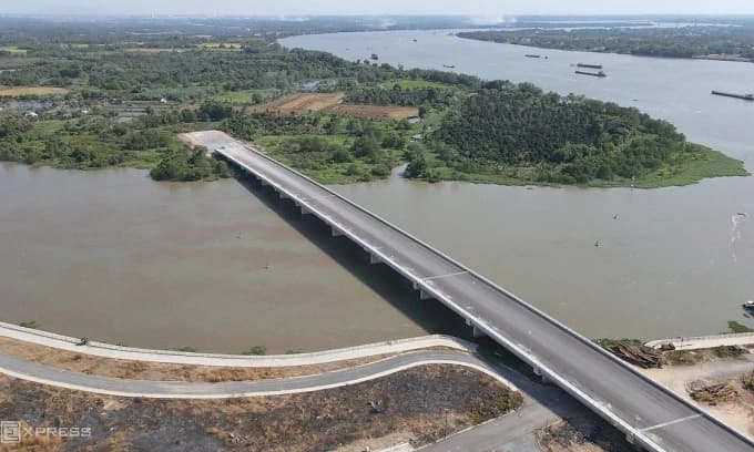
Cat Lai Bridge
The Cat Lai Bridge will extend approximately 11.6 kilometers with a main bridge of about 3 kilometers. The design allows speeds up to 80 kph and includes six lanes for motor vehicles plus two lanes for non motorized traffic. The corridor will connect Nguyen Thi Dinh Street in Ho Chi Minh City’s Cat Lai Ward with Dai Phuoc Commune in Dong Nai. With an estimated cost of more than VND20.5 trillion, construction is expected to begin by late 2025 and complete in 2028. Once open, Cat Lai will provide a high capacity alternative to ferry services and will remove a long standing bottleneck on the eastern edge of the city where port traffic, residential growth, and industrial logistics converge.
Dong Nai 2, also known as Long Hung Bridge
The Dong Nai 2 project creates a 12 kilometer corridor, including a bridge section of about 2.3 kilometers over the river. It links National Highway 51 in Tam Phuoc Ward to Ring Road 3 in Long Phuoc Ward. The design includes six lanes for motor vehicles and two for light vehicles. The total investment is around VND11.76 trillion. By tying National Highway 51, a major axis running through Dong Nai and toward Ba Ria Vung Tau, to the metropolitan ring road network, this corridor will provide a new east west spine that can funnel airport traffic away from already congested routes.
How the new links will change the trip to the new airport
For drivers, the most immediate gain will be choices. Today, travel between the city and the Long Thanh area relies mostly on the Ho Chi Minh City to Long Thanh to Dau Giay Expressway and a few aging bridges. The Cat Lai and Dong Nai 2 corridors will add two high capacity alternatives, each designed to slot traffic into ring roads and expressways in a more even way.
Cat Lai will help redistribute flow from the southern and eastern districts of Ho Chi Minh City and from the port zone, reducing pressure on the existing expressway long before drivers reach the usual choke points. Dong Nai 2 will open a new path from National Highway 51 toward Ring Road 3, which is emerging as the main belt carrying traffic around the city and toward Long Thanh. Huong Lo 2, once extended, becomes a direct connector for Dong Nai residents and freight to reach the expressway without doubling back to busier junctions.
For freight, shorter routes and fewer river crossing delays can translate to lower logistics costs. Factories in Nhon Trach and Long Thanh districts will be able to reach the airport and ports with improved reliability, which is crucial for exporters that depend on tight delivery windows. Added redundancy also improves resilience when one bridge requires maintenance or an accident blocks a lane.
Airport timetable and on the ground progress
Long Thanh International Airport is Vietnam’s largest aviation project to date. Phase one covers a 5,000 hectare site and includes one runway, a passenger terminal, and support facilities designed for up to 25 million passengers and about 1.2 million tons of cargo per year. Technical flights are targeted to begin in December 2025, with the start of commercial operations planned for mid 2026. Over time, the project is set to reach four runways across three phases with an eventual capacity close to 100 million passengers a year.
The Airports Corporation of Vietnam (ACV), a majority state owned operator, leads development and has funded large portions of early works from its own reserves while arranging domestic credit lines to cover later stages. After re bidding in recent years, major contracts for the terminal and airside works were awarded and construction accelerated. The project has faced familiar challenges, including complex land clearance and supply chain issues, yet recent site activity has intensified under government oversight.
Connectivity remains the essential piece during the first operating years. The airport lies about 40 kilometers from downtown Ho Chi Minh City with no rail link at opening. Reliable ground access through expressways, ring roads, and the new bridges is critical to keep trips predictable for travelers and to ensure that airlines can schedule with confidence from day one.
Rail plans move forward, with a focus on the Thu Thiem to Long Thanh line
City and provincial leaders are also pushing for rail to anchor future access. A proposed railway from Thu Thiem, the new financial district in east Ho Chi Minh City, to Long Thanh Airport is under active study. Early estimates suggest the line could carry on the order of 30,000 to 40,000 passengers per hour in each direction, with an investment requirement around 3.5 billion USD. Local authorities have discussed using a public private partnership model and have called for a single locality to serve as the lead authority to speed decisions.
Longer term plans also include a station for the north south high speed railway at Long Thanh and a possible light rail connection toward the city. These would integrate with existing and planned urban transit in Ho Chi Minh City, including Metro Line 1, to provide a chain of transfers that can move people from the airport to the urban core without relying on private cars. The rail components will take years to deliver, so near term improvements will come from roads, buses, and park and ride systems that can bridge the gap until rail opens.
In practice, early years of airport operation are likely to depend on a mix of express buses, ride hailing services, taxis, private cars, and company shuttles. Dedicated lanes along parts of the network, clear wayfinding, and a coordinated timetable with flight banks can keep these services efficient until rail comes online.
Ring roads and expressway upgrades unlock access
One of the current bottlenecks is the Ho Chi Minh City to Long Thanh to Dau Giay Expressway, the main route feeding the airport area. Traffic volumes often exceed design capacity during rush hours. An expansion project to widen the route to eight to ten lanes, with an investment of more than VND15 trillion, has been identified as a priority. Increasing lane capacity on this corridor will complement the new connectors, so that traffic entering the expressway can continue moving at steady speeds.
Ring Road 3 around Ho Chi Minh City is another key element. As sections open, including the Tan Van to Nhon Trach alignment that crosses the Dong Nai River, the ring will give drivers and buses a way to bypass the inner city and reach Long Thanh from multiple directions. Dong Nai 2 is planned to feed directly into Ring Road 3, while Cat Lai will draw traffic from the eastern districts. These links help distribute flows more evenly and reduce pressure on central arteries.
Who pays for what, and why PPP matters
The approved package uses a mix of public and private capital. Huong Lo 2 phase two will be delivered under a public private partnership, with the state contributing funding for land clearance. This approach aims to mobilize private investment for construction while the local budget focuses on land, a common structure for large road projects in Vietnam.
Land clearance is often the hardest step. The Long Thanh area has seen extensive relocation for the airport itself, and additional right of way is required for new bridges and roads. Transparent compensation, resettlement support, and early coordination across districts can shorten timelines. Investors look for clear schedules and predictable approvals, and the use of a single lead agency across provincial boundaries can reduce delays.
Economic ripple effects across the southern growth belt
Better connections to Long Thanh are expected to lift tourism, trade, and investment. For airlines and logistics firms, a reliable ground network expands the catchment area for the airport and supports cargo operations. Manufacturers in Dong Nai, Binh Duong, and the eastern districts of Ho Chi Minh City will have additional corridors to reach the airport and deep water ports, improving delivery times for export goods.
Authorities are also planning an airport city with logistics parks, maintenance zones, and service areas near the terminals. If coordinated with land use plans, the new bridges can steer development toward areas with strong transport access, reducing pressure on crowded urban neighborhoods. New jobs in construction, operations, and services will follow as airport activity scales up from the first phase to later expansions.
For travelers, the combination of added river crossings, a widened expressway, and a growing ring road system should cut variability in trip times. Once rail opens, frequent trains from Thu Thiem to Long Thanh can shift more trips away from private cars and reinforce the airport’s role as a true regional hub for the south of Vietnam.
Risks, timelines, and safeguards
Large transport projects carry risks. Land acquisition and resettlement can run behind schedule. Material supply and contractor capacity can strain timelines when many projects move at once. Bridges over the Dong Nai River must satisfy navigation requirements and strict safety standards, which adds engineering complexity. Effective sequencing will be essential so that new routes come online in sync with airport milestones.
To maintain momentum, national leaders have pressed ministries and localities to remove bottlenecks on major transport works, including Long Thanh. Clear procurement, quality control, and timely payments help contractors keep resources on site. With several of the region’s key corridors now under construction or in final preparation, the coming three years will be a test of coordination between Ho Chi Minh City, Dong Nai, and neighboring provinces so that the pieces connect as planned.
What to Know
- Dong Nai approved more than VND37 trillion (about 1.45 billion USD) to build links between Ho Chi Minh City and Long Thanh International Airport.
- The plan includes Cat Lai Bridge, Dong Nai 2 (Long Hung) Bridge, and the second phase of Huong Lo 2 Road.
- Huong Lo 2 phase two will extend 7.5 kilometers from Vam Cai Sut Bridge to the expressway under a PPP contract worth more than VND5.9 trillion.
- Cat Lai Bridge will be 11.6 kilometers long, with six motor lanes and two lanes for non motorized traffic, targeted for completion in 2028.
- Dong Nai 2 will create a 12 kilometer corridor, including a 2.3 kilometer bridge, linking National Highway 51 to Ring Road 3.
- Long Thanh Airport plans technical flights in December 2025 and commercial service starting mid 2026 in phase one.
- Expressway widening to eight to ten lanes and Ring Road 3 openings will work with the new bridges to reduce congestion.
- A proposed railway from Thu Thiem to Long Thanh is under study, with projected high passenger capacity and an estimated cost around 3.5 billion USD.