A high mountain metropolis challenges Silk Road myths
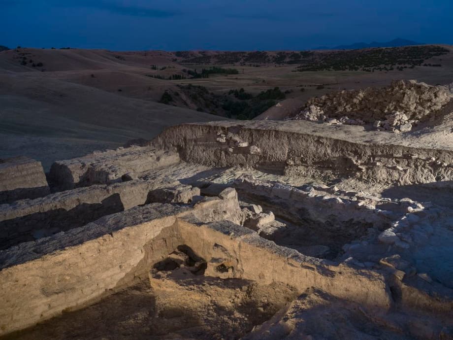
Archaeologists working in the mountain ranges of eastern Uzbekistan say a vast settlement known locally as Tugunbulak may be the long lost city of Marsmanda, a center for iron making that fed markets across Asia. The site sits at roughly 7,000 feet above sea level in a grassy upland and dates to the period between the sixth and eleventh centuries. Covering about 300 acres and ringed in places by strong walls and towers, it appears to have been an industrial city in a place many once considered too remote for major urban life.
- A high mountain metropolis challenges Silk Road myths
- What archaeologists found on the plateau
- How lidar revealed the invisible city
- Is Tugunbulak the Marsmanda of medieval chronicles
- Rethinking nomads and the Silk Road
- Why the city declined around the eleventh century
- Comparisons from across Central Asia
- What comes next for research
- Highlights
Excavations and survey have brought to light industrial kilns, thick spreads of iron slag, and rocks rich in iron ore. The team also recorded corridors, terraced platforms, defensive towers, and multistory building footprints mapped across four distinct sectors. Medieval geographers described Marsmanda as a cold city in the mountains where the rivers froze and where regular fairs drew merchants to trade iron objects and weapons. The archaeological record at Tugunbulak matches those descriptions with a precision that has surprised many researchers.
The work is led by archaeologist Michael Frachetti of Washington University in St. Louis with Farhod Maksudov of the National Center of Archaeology of Uzbekistan and Sanjyot Mehendale of the University of California, Berkeley. Using drones equipped with lidar, the team created a high resolution map of a settlement so large that it had been hiding in plain sight beneath grasslands and erosion for centuries. Excavations since 2022 have begun to ground truth the survey and to uncover daily life within the walls.
What archaeologists found on the plateau
The visible footprint at Tugunbulak unfolds over a broad slope that descends toward alpine pastures. Inside the walls, archaeologists recorded narrow passageways, wide plazas, and rows of terraced house platforms. A central stronghold occupies the highest point, surrounded by curtain walls and watchtowers that controlled entry. The city layout suggests deliberate planning and an authority capable of organizing construction at scale.
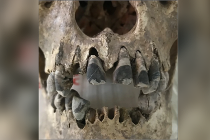
Artifacts from the first excavation seasons include iron arrowheads, knives, tools, and coins. A remarkable burial contained the remains of a mounted warrior interred with his horse and grave goods. The rite aligns with Turkic traditions known across the steppe in the early medieval era. Ceramic styles and personal objects point to contact between Turkic pastoralists and settled communities, including traders with cultural roots in the Sogdian world. The material paints a picture of a hybrid society of farmers, herders, miners, and metallurgists living side by side.
Evidence of an iron industry at scale
Everywhere in the city, excavators encountered the traces of metalworking. Furnaces or kilns for smelting and smithing lie near mounds of slag, the glassy by product of extracting metal from ore. Lumps of iron rich stone speak to the mechanics of the industry. The concentration of industrial debris inside a main tower and across workshops suggests that Tugunbulak produced weapons, tools, and fittings for regional markets tied into the Silk Road caravans.
Iron production in this period relied on bloomery furnaces. Workers heated ore with charcoal so oxygen could bond with impurities that then drained away as slag, leaving a spongy mass of iron called a bloom. Smiths then hammered and reheated the bloom to drive out more slag and to shape blades, nails, and fittings. Charcoal was the essential fuel. Making it required steady supplies of wood, which means the forests around Tugunbulak were a critical resource that could have faced heavy pressure during peak production.
How lidar revealed the invisible city
Lidar, short for light detection and ranging, uses rapid laser pulses to measure distance and to build a precise 3D model of the ground surface. When drones fly lidar above a site, software can filter out vegetation and reveal subtle rises and depressions that mark buried walls, roads, and buildings. At Tugunbulak, this method transformed a rolling grass slope into a detailed city map in digital form. The scan traced fortifications, internal roadways, and an interconnected web of terraces that field teams later checked on the ground.
The lidar maps show four urban sectors with distinct functions. A central fortress or citadel anchors the complex, with corridors that funnel movement toward gates and plazas. Around these core defenses lie hundreds of terraced structures, likely a mix of homes, workshops, and storage spaces. Erosion and grazing had long blurred these outlines. The laser survey cut through that camouflage and gave archaeologists a blueprint for targeted excavation.
Two mountain centers, one larger than many lowland peers
Tugunbulak is not alone on this mountain shelf. Just a few miles away, the team mapped Tashbulak, a smaller but well organized city of about 30 acres. Both settlements sit above 7,000 feet in elevation and were occupied from roughly the sixth through the eleventh centuries, when caravans moved goods across Central Asia and the Middle East. The two centers likely shared labor, resources, and routes over the high passes.
Comparative analysis shows how unusual Tugunbulak is for its altitude. Few cities anywhere in Central Asia grew to a similar size at this height. Historical context places the region under the sway of Turkic powers that later gave way to the Qarakhanids. Merchants with Sogdian roots likely moved through these uplands, while local communities managed pastures, mines, and furnaces that turned ore into tradable goods.
Is Tugunbulak the Marsmanda of medieval chronicles
Medieval Arabic and Persian authors wrote about a mountain city called Marsmanda where the rivers froze in winter and where monthly fairs offered iron objects and weapons. Those clues fit the location and the material at Tugunbulak, from the cold high elevation to the clear imprint of an iron economy. If the identification holds, Marsmanda would be one of the largest known mountain cities tied into Silk Road trade.
The case is persuasive but not yet conclusive. Future seasons will focus on administrative areas that could yield inscriptions or seals, on coin hoards that fix dates more precisely, and on industrial quarters that might provide production scales. Field laboratories will analyze slag chemistry to pin down ore sources and to track how metal moved through workshops to finished goods.
Rethinking nomads and the Silk Road
Early scholarship emphasized the role of great lowland cities such as Samarkand, Bukhara, and Kashgar and treated mountain ranges as barriers that caravans hurried to cross. New work in the Uzbek uplands presents a different picture. Highland communities did not sit at the margins of exchange. They produced vital materials, guarded strategic passes, and linked herders, miners, and merchants in a tight regional network.
The material at Tugunbulak shows pastoralists who were also craftspeople. Herders can move quickly across slopes, drive pack animals, and draw on seasonal pastures. In this case they also tapped ore bodies, made charcoal, and worked as miners and smiths. That mix of skills makes sense in a zone where mobility and local resources decide economic success. It also blurs any simple line between nomad and settler.
What iron meant for power and everyday life
Iron tools and weapons sit at the heart of medieval life in Central Asia. Arrowheads, spearpoints, and blades supplied armies. Bits, stirrups, and horseshoes equipped cavalry and caravans. Axes, nails, plowshares, and sickles drove agriculture and building. A city capable of producing these at scale would have had buyers from many directions and across many cultures.
These materials leave distinct archaeological traces. Slag mounds grow around furnaces. Layers of hammer scale, tiny flakes of iron produced by smithing, can accumulate on workshop floors. At Tugunbulak, extensive slag deposits combined with weapon parts and tools strengthen the case that the city powered a metal economy reaching well beyond the mountain valleys.
Why the city declined around the eleventh century
Radiocarbon results and field stratigraphy indicate that activity at both Tugunbulak and nearby Tashbulak tapered off in the first half of the eleventh century. Researchers suggest several overlapping pressures. Charcoal had to be made in volume, which can deplete forests around a city and push fuel gathering farther from the furnaces. Shorter growing seasons or harsher winters would have hit pastures and travel. Political fragmentation could have redirected caravans and buyers. New competitors may also have cut into markets for iron goods.
These are hypotheses that archaeologists will test by combining environmental sampling, timber studies, and settlement surveys across the wider region. Whatever the cause, the decline of this mountain industry shows how sensitive upland economies can be to changes in climate, politics, and resource use.
Comparisons from across Central Asia
Recent work at Lake Issyk Kul in Kyrgyzstan offers a revealing comparison. Underwater surveys there have mapped a medieval trading center now submerged a short distance from shore. Excavations documented fired brick buildings, a large millstone, wooden beams, and a Muslim cemetery with burials oriented toward Mecca. Researchers link the city’s demise to a powerful earthquake in the fifteenth century that devastated the settlement as lake levels rose. The find highlights a different type of mountain Silk Road hub, one that thrived on a lakeshore rather than a plateau.
Both cases show how diverse the Silk Road really was. Mountain corridors included plazas for fairs, workshops for iron and ceramics, religious centers, and way stations for caravans. Some cities fell to environmental shocks, others to political change or resource fatigue. Many left traces that are subtle from the ground but vivid in lidar scans and underwater surveys.
What comes next for research
The team at Tugunbulak plans to expand excavations across administrative districts, craft sectors, and domestic neighborhoods. Detailed metallographic study of blooms, slag, and finished objects will clarify whether craftspeople produced steel or mainly low carbon iron and how they treated and finished blades. Geoarchaeological sampling will rebuild the ancient landscape, from woodlands converted into charcoal clamps to quarries that fed ore to the furnaces.
Regional survey will seek other high elevation settlements across the Uzbek uplands. If additional cities linked by caravan tracks come to light, the mountain belt will emerge as a continuous urban zone rather than isolated outposts. Training and collaboration with Uzbek institutions will be central, along with careful conservation of walls, towers, and terraces that are now exposed to the elements.
Highlights
- Archaeologists mapped a 300 acre city at Tugunbulak in the Uzbekistan mountains, occupied from the sixth to eleventh centuries.
- Industrial kilns, iron slag, and iron rich rocks show large scale metalworking across the site.
- Drone lidar revealed four urban sectors, fortifications, corridors, and hundreds of terraced structures.
- Finds include iron weapons and tools, coins, and a Turkic warrior burial with a horse.
- Researchers argue Tugunbulak may be Marsmanda, described in medieval texts as a cold mountain city known for iron and regular trade fairs.
- Tugunbulak likely supplied weapons, tools, and fittings to Silk Road markets across Central Asia.
- Activity declined in the early eleventh century, possibly linked to environmental stress, political shifts, or new competition.
- A submerged medieval trading center at Lake Issyk Kul in Kyrgyzstan offers a regional comparison of mountain Silk Road urban life and its varied fates.