Ash rises 6 kilometers as Flores faces renewed danger
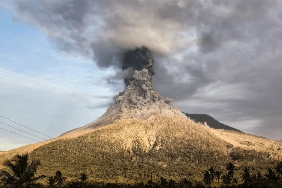
Indonesia's Geological Agency raised Mount Lewotobi Laki-Laki to its highest alert level late on Friday, September 19, 2025, after a series of eruptions sent ash high above the island of Flores. The strongest explosion that evening produced a column about 6 kilometers above the peak, forcing Frans Seda Airport in Maumere to suspend operations.
Contents
- Ash rises 6 kilometers as Flores faces renewed danger
- What changed on September 19?
- Why the exclusion zone extends farther in some directions
- Maumere shuts flights while Bali stays open
- Why volcanic ash is dangerous for aircraft
- What the instruments reveal beneath the summit
- How the latest eruptions fit the recent timeline
- Residents face ash on homes, crops and roads
- Tourism on Flores meets renewed restrictions
- What officials will watch next
- Key Points
Fresh eruptions continued into Saturday, September 20, including one that sent ash roughly 2.5 kilometers above the summit. Authorities ordered people to stay at least 6 kilometers from the crater, with the exclusion zone extending to 7 kilometers along a sector running from southwest to northeast.
Bali's main airport remained open and reported normal operations on Saturday. Around Flores, however, the ash clouds brought renewed uncertainty for passengers, airlines and communities already coping with repeated eruptions. Local disaster agencies said there were no immediate reports of casualties from the latest events.
Residents near rivers draining the volcano faced another danger: heavy rain could turn fresh ash and loose rock into fast moving volcanic floods called lahars. These mixtures of water, ash and debris can surge through channels with little warning, threatening villages, roads and bridges downstream.
Lewotobi consists of two adjacent volcanic peaks, Laki-Laki and Perempuan, whose summits are less than 2 kilometers apart. Laki-Laki stands about 1,584 meters high and is the more active peak. Perempuan is taller but much calmer. The latest explosions continued a period of unrest that has brought alternating quiet spells and vigorous eruptions since late 2023.
For people living near the mountain, the immediate priorities were keeping outside the exclusion zone, limiting exposure to ash and watching river valleys during rain. For travelers, the immediate consequence was a closed airport in Maumere, while the wider aviation network watched where the ash would move.
What changed on September 19?
Monitoring instruments recorded a clear increase in activity on Friday. The national volcanology agency documented at least a dozen explosive events beginning in the afternoon, with eruptions becoming stronger into the night. At about 10:46 p.m. local time, one ash column reached around 6,000 meters above the vent.
The decision to raise the alert rested on more than the height of the ash. Scientists also assessed the pattern of earthquake signals and changes in the volcano's shape measured in recent days. Those observations help them track pressure and movement beneath the surface, even when the summit appears relatively quiet.
Saturday morning brought further explosions and ash emissions, including the plume that rose roughly 2.5 kilometers. Monitoring at the volcano and by the national volcanology center showed that the Friday evening sequence was continuing.
Authorities reinforced restrictions on the western and northeastern flanks. Previous deposits and the shape of the land can direct hot flows and dense ash clouds into particular areas, making some sectors more exposed than others at the same distance from the crater.
Officials also warned that heavy rainfall could move the newly deposited material into rivers. A slope covered in loose ash and stones can become the starting point for a powerful mudflow, carrying the eruption's danger well beyond the summit.
Why the exclusion zone extends farther in some directions
The Geological Agency's instructions established a basic exclusion radius of 6 kilometers, widened to 7 kilometers along the southwest to northeast sector. Residents, visitors and anyone considering travel near the volcano were told to respect those boundaries.
Muhammad Wafid, chief of the Geological Agency, set out the distance people should keep and the consequences ash could have for flights:
Residents and tourists should stay at least 6 kilometers from the crater. Volcanic ash can disrupt airport operations and flight paths.
A circular boundary is a starting point for volcanic safety planning. Scientists adjust it to account for the cone's shape, openings in the crater and routes followed by earlier flows. At Lewotobi, both summit craters are breached to the north, and the surrounding terrain channels moving material along particular flanks.
Pyroclastic density currents are fast, extremely hot mixtures of volcanic material and gas that can rush down valleys and outrun people on foot. The extended sector reflects routes where these currents, thick ash clouds or ballistic ejecta, rocks thrown out during an explosion, could travel.
Lahars can follow the same channels after an eruption has eased. Heavy rain mixes water with loose ash and rock, creating a slurry that can carry boulders, logs and other debris. These flows can be as destructive as the eruption itself, and the risk can continue for months while material remains on the slopes.
Maumere shuts flights while Bali stays open
Frans Seda Airport in Maumere suspended operations after Friday night's eruptions. Volcanic ash can damage aircraft engines, reduce visibility and settle on runways and ground equipment, making airport operations difficult even when other weather conditions appear clear.
Partahian Panjaitan, head of the airport, said officials would assess the situation after a period of observation. Reopening would depend on the volcano's behavior over the next day:
We will monitor developments before deciding whether to reopen.
No definite reopening time was given. Passengers faced delays or rerouting, and airlines advised travelers to check flight status around Flores and across the wider region.
Bali's main airport, a major hub for international tourism and the busiest international gateway in Indonesia's east, reported normal operations on Saturday. Operators said conditions did not warrant diversions.
Gede Eka Sandi Asmadi, a spokesperson at Bali's airport, said there had been no disruption on Saturday:
Operations are normal at Bali's airport,
Wind direction, ash density and cloud height determine which flight routes are affected. A change in the wind, or a taller and denser eruption cloud, can alter airport conditions quickly. Ash can drift far from the volcano and remain at heights used by aircraft.
The region had already experienced major disruption from Lewotobi earlier in the year. On July 7, 2025, an eruption sent ash about 18 kilometers high, and airports across the region canceled dozens of flights. Satellite instruments later mapped the cloud's movement across the archipelago.
Why volcanic ash is dangerous for aircraft
Volcanic ash consists of tiny, jagged particles of rock and glass. It forms when magma breaks apart as its gases expand and pressure falls. Unlike smoke or steam, these particles can wear down or obstruct aircraft components.
A jet passing through a thick ash cloud can have its cockpit windows sandblasted. Ash can clog pitot tubes, the instruments used to measure airspeed, and other sensors. Particles entering an engine can erode turbine blades or melt in its hottest sections.
The melted material can then harden again on turbine blades and vanes, reducing engine power. In the worst cases, ash ingestion can cause an engine flameout. Even a thin ash haze can increase wear on engines and sensors.
Pilots avoid known ash clouds, while aviation meteorologists use rapid satellite detection and reports from pilots to draw advisories identifying areas aircraft should avoid. Flight planners assess the plume's height, density and direction, and air traffic controllers and airlines may change routes or altitudes or cancel services when safety margins shrink.
Indonesia lies along the tectonic arcs of the Pacific Ring of Fire and has more than 120 active volcanoes. Air routes across Southeast Asia pass between volcanic peaks and areas downwind of them. That geography makes the speed of ash detection and decisions about flight paths especially important during an eruption.
What the instruments reveal beneath the summit
Scientists monitor Lewotobi with seismometers, tiltmeters and GNSS stations. Seismometers detect small volcanic earthquakes. Tiltmeters measure tiny changes in the slope of the ground, while GNSS stations use satellite positioning to track ground movement across longer distances.
Before the latest escalation, the monitoring network recorded periods of continuous tremor, clusters of low frequency earthquakes and signs of shallow inflation. Inflation means the ground is swelling. Together, these signals fit with magma and gas moving through the volcano's internal passage, or conduit.
Technicians also observed steady white emissions at times, indicating the release of gas from the summit. If the conduit becomes blocked, pressure can build until an explosive release occurs. This helps explain why a sudden ash column can follow an interval that looks quiet from outside.
Satellites add information that instruments on the ground cannot provide alone. Sensors on satellites passing over the polar regions, including VIIRS, the Visible Infrared Imaging Radiometer Suite, can detect hot spots and map ash clouds that people cannot see with the naked eye at night.
Aviation forecasters use these observations to estimate where ash is traveling. Local authorities can also use them to focus inspections on villages and road corridors downwind that may need cleanup or assistance. Field observations, earthquake measurements, ground deformation and satellite images together provide a layered picture of the volcano's condition.
How the latest eruptions fit the recent timeline
Lewotobi Laki-Laki has moved through repeated active phases since late 2023. Its alert level has shifted between high settings and slightly lower ones as activity has increased or eased. The September escalation followed several serious episodes during the preceding months.
- Late 2023: The volcano entered the continuing period of activity, with quiet intervals between stronger phases.
- November 2024: An especially intense period brought deadly explosive eruptions and widespread ashfall.
- Early 2025: Further eruptions occurred, including a period of activity in March.
- June 17, 2025: Authorities set the highest alert level after tall ash emissions and unrest.
- July 7, 2025: An eruption produced an ash cloud roughly 18 kilometers high and pyroclastic flows that traveled up to 5 kilometers down the flanks.
- September 19, 2025: At least a dozen explosive events were recorded from the afternoon, and the alert was raised to the highest level late that night.
- September 20, 2025: Further eruptions continued in the morning as Maumere's airport remained suspended and Bali reported normal operations.
The July cloud rose into the upper troposphere and lower stratosphere, reaching the higher parts of the atmosphere. Villages reported heavy ashfall during that event. NASA's Earth Observatory later published satellite images showing the plume and its direction of travel.
NASA noted that increased earthquake activity and inflation of the ground had preceded the July eruption. Those changes suggested magma was moving upward and pressurizing the system.
The twin peaks have different eruption histories. Laki-Laki has erupted frequently since the 19th century, while confirmed eruptions at the taller Perempuan peak were recorded in 1921 and 1935.
Residents face ash on homes, crops and roads
People living within sight of Lewotobi reported ash settling on homes and crops after the Friday and Saturday eruptions. Villages on the flanks that received thick ash during previous episodes were already carrying out periodic cleanup, especially on rooftops.
Ash can irritate eyes and lungs, contaminate water sources, abrade painted surfaces and damage electronics when it gets inside equipment. On roofs, accumulated ash becomes particularly dangerous when wet because the added water increases its weight.
Local officials advised people to cover their nose and mouth with masks or cloth during ashfall. People with respiratory conditions were urged to limit time outdoors when ash was in the air. Closing windows and placing damp cloth at gaps around doors can help keep indoor air clearer.
Households were encouraged to keep simple masks available, store clean water and secure livestock during ashfall. Guidance also included gently sweeping ash from roofs to avoid collapse and keeping gutters and drains clear.
Farmers often need to rinse leaves and clear irrigation tracks after ash settles. Drivers were advised to slow down on roads coated with ash because the powdery surface increases stopping distances.
Emergency officials urged communities to avoid riverbanks during storms and plan alternative routes in case lahars block roads or damage bridges. Earlier phases of the eruption had prompted the evacuation of the most exposed households from areas near the crater rim and known flow channels.
If activity intensifies again, authorities could widen the exclusion radius or add sectoral restrictions to keep people away from the most likely routes of hot debris and ash clouds. Local governments were asked to coordinate with the volcano observation post and the national mitigation center, including watching rainfall totals, inspecting bridges and culverts after storms and preparing cleanup supplies.
Tourism on Flores meets renewed restrictions
Flores attracts visitors for its reefs, islands and volcanic scenery. The latest eruptions complicated travel through Maumere, where the airport closure meant passengers had to wait or seek different routes.
Climbing routes around Lewotobi were off limits while the highest alert remained in force. Local authorities also discouraged sightseeing near the volcano because winds can shift and fresh ash bursts can arrive with little warning.
Travelers were advised to follow the regional disaster management agency's directions and consult official channels before taking overland routes through river valleys draining the mountain. An open airport elsewhere in the region does not remove the need to check conditions along the journey.
What officials will watch next
Scientists will look for new lava at the crater and signs of flows on the flanks. Either would indicate that magma continues to reach shallow levels. The volcano's recent pattern of eruptions arriving in pulses means conditions can change rapidly.
Authorities could lower the alert if activity declines. Ash and debris already deposited on the slopes would still leave communities exposed to lahars during storms, requiring continued attention to rainfall and river channels.
Satellite observations will continue to track the plume and help identify where ash is traveling. NASA's Earth Observatory provides periodic updates and imagery, including its July plume imagery, that illustrate the cloud's height and direction.
Combined with measurements on the ground, those observations help forecasters and local leaders assess a changing situation. As of September 20, the immediate decisions centered on maintaining the exclusion zone, monitoring the volcano and determining when conditions would allow Maumere's airport to reopen.
Key Points
- Indonesia raised Lewotobi Laki-Laki to its highest alert level late on September 19, 2025.
- The strongest Friday eruption sent ash about 6 kilometers above the peak; a Saturday plume reached roughly 2.5 kilometers.
- The exclusion zone extends 6 kilometers from the crater and 7 kilometers along the southwest to northeast sector.
- Frans Seda Airport in Maumere suspended operations, while Bali's airport reported normal operations on September 20.
- Local disaster agencies reported no immediate casualties from the latest eruptions.
- Heavy rain could send lahars through rivers draining the volcano, threatening roads, bridges and villages.
- The July 7 eruption produced an ash cloud roughly 18 kilometers high and pyroclastic flows reaching up to 5 kilometers.
- Ground instruments and satellites are tracking earthquake activity, changes in the volcano's shape and the movement of ash.