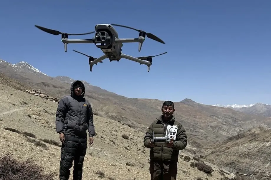
Small Aircraft Take on a Vast Conservation Task
A drone costing about $2,500, launched by hand and equipped with a camera and GPS, helped open a new chapter in wildlife protection in Nepal in 2012. Those early aircraft had a wingspan of two meters, a range of up to 25 kilometers and flight times of 45 to 50 minutes. They gave conservation teams a way to photograph remote ground that rangers struggled to reach on foot.
Contents
- Small Aircraft Take on a Vast Conservation Task
- Why Chitwan and Bardia Needed Another View
- How the First Trials Developed
- What Drones Do Inside and Around the Parks
- Thermal Cameras and Aircraft That Need No Runway
- How Artificial Intelligence Helps Count Animals
- What Has Changed for Wildlife Protection
- Village Safety Depends on Local Volunteers
- Privacy, Trust and the Cost of Keeping Drones Flying
- Nepal's Experience in a Wider Conservation Effort
- Key Points
By August 25, 2025, drones had become part of a wider effort to protect Bengal tigers, one-horned rhinoceroses, Asian elephants and other wildlife. Their work stretches from watching park boundaries for suspicious activity to helping volunteers locate animals that have wandered into villages. Newer equipment adds thermal cameras, longer flights and artificial intelligence to the basic task of seeing a large area from above.
Nepal's experience brings together two sides of conservation: the ability to gather information quickly and the need for people who can act on it. Rangers, army personnel, researchers and community volunteers remain central to the work. A camera in the sky can help them find an animal or spot a threat, while decisions and action still take place on the ground.
The change matters in the dense jungles and grasslands of Nepal's southern lowlands, where poaching, habitat loss and conflict between people and wildlife put pressure on both animals and nearby communities. Drones have expanded what conservation teams can see, but their success also depends on training, reliable equipment, public trust and respect for the people living beside protected areas.
Why Chitwan and Bardia Needed Another View
Chitwan and Bardia national parks contain globally significant populations of tigers, rhinos and elephants. They also shelter critically endangered gharials, a distinctive crocodile species. Protecting these animals means monitoring large areas of forest, grassland and park boundaries where poachers and expanding human settlements create continuing pressure.
Rangers have traditionally patrolled on foot, by bicycle and even on elephants. Those methods remain essential, but covering vast or inaccessible terrain can be slow and dangerous. Armed poachers add another risk for the people responsible for protecting wildlife.
Drones, also called unmanned aerial vehicles or UAVs, carry cameras over areas that would take much longer to inspect from the ground. They can bring back photographs and video that help teams decide where to direct a patrol. Their practical value lies in giving people a wider view before they travel into difficult terrain.
General Krishna Acharya, director of Nepal's Department of National Parks and Wildlife Conservation, described the advantage for rangers confronting armed poachers:
Technologies like non-lethal UAVs could give park rangers a vital advantage against armed poachers.
How the First Trials Developed
Nepal became one of the first countries in Asia to test drones for conservation in 2012. WWF Nepal worked with international researchers, using lightweight aircraft developed by ecologist Lian Pin Koh and biologist Serge Wich. The early machines were small planes launched by hand, with cameras and GPS to record images and locations.
Their price of about $2,500 per aircraft put the technology within reach of a developing country working with modest conservation budgets. Their high resolution photographs and videos offered information about places that were difficult for rangers to visit.
- 2012: Nepal began testing conservation drones through a partnership involving WWF Nepal and international researchers.
- By August 25, 2025: Conservation uses included wildlife monitoring, patrol support, responses to animals entering villages, habitat surveys and population counting, alongside advances in cameras and automated image analysis.
Training park rangers and army personnel to operate UAVs turned the aircraft into working conservation tools. The development involved more than buying equipment: teams also needed people capable of flying it and using the information it collected.
What Drones Do Inside and Around the Parks
Wildlife monitoring is one of the main uses. Aerial surveys help teams track the movements and health of tigers, rhinos, elephants and other species. Cameras can also help detect new or elusive species in habitats that are hard to reach.
Park boundaries and places where illegal activity is more likely are another focus. UAVs can provide live video that helps rangers respond quickly to suspicious movements. Their presence can also deter poachers and illegal loggers. Photographic evidence gathered during this work has strengthened wildlife crime enforcement and prosecution.
Regular flights give conservation teams a record of the habitat itself. Images document changes in land use, deforestation and encroachment, providing information for conservation planning over time. An aircraft used to look for wildlife can therefore also help show how the land around that wildlife is changing.
Gokarna Jung Thapa, head of geoinformatics and technology at WWF Nepal, described drones as a:
crucial conservation tool
Thapa's description places drones alongside established conservation methods. Ground patrols and local knowledge remain part of the same effort, with aerial information helping teams carry out their work more effectively.
Thermal Cameras and Aircraft That Need No Runway
Modern conservation drones have moved beyond the simpler cameras carried by the first aircraft. Thermal cameras support surveillance at night and the detection of animals or people hidden by dense foliage. Thermal imaging records heat, giving operators another way to look for living subjects when ordinary images are difficult to use.
Vertical takeoff and landing, commonly shortened to VTOL, allows an aircraft to rise and land without a runway. That capability is useful in confined spaces and rugged terrain, where finding a suitable place to operate a conventional aircraft can be difficult.
Advanced drones can fly for more than an hour and cover up to 30 kilometers. Compared with the initial aircraft's 45 to 50 minutes and range of up to 25 kilometers, those figures show how operating time and reach have expanded.
Geotagging adds location information to photographs. For a conservation team, that means an image can be connected to the place where it was taken, making detailed aerial records more useful for mapping habitats, following changes and planning visits on the ground.
How Artificial Intelligence Helps Count Animals
High resolution drone images can support population censuses, including counts of swamp deer and gharials, without requiring people to approach every animal. Artificial intelligence helps process those images by identifying objects that may otherwise have to be found through lengthy visual checks.
Deep learning algorithms learn patterns in images and use them to identify likely objects or species. YOLO, short for You Only Look Once, is one such system used for object detection. It can support detection and species identification as drone footage is collected.
Recent studies described in the conservation account recorded more than 92% precision in detecting and counting animals such as swamp deer, even without expensive hardware. Precision describes how often a system's positive identifications are correct. That measure helps explain the usefulness of automated detection when a team is searching through many images.
More accessible equipment and automated analysis give teams with limited resources additional ways to survey wildlife. The practical chain remains straightforward: a drone collects images, software helps identify animals, and conservation workers use the results to understand populations and plan their work.
What Has Changed for Wildlife Protection
Nepal has reported successes in wildlife protection since introducing drones. Rangers and army personnel trained to operate them have been able to monitor large areas more efficiently and safely. Aerial photographs also provide records that can support action against wildlife crime.
In Chitwan National Park, drones have helped reduce poaching incidents and contributed to the recovery of rhino and tiger populations. Their role sits within a broader conservation effort involving patrols, enforcement and people working in and around the park.
Conservation flights also support decisions that extend beyond an immediate patrol. Repeated images of forest loss or encroachment can help planners follow habitat changes, while wildlife surveys provide information about where animals are moving and how populations are doing.
The account gives no figures for the number of poaching incidents prevented or the share of population recovery attributable to drones. The reported gains are therefore described through the tasks drones support: wider monitoring, quicker responses, photographic evidence and better information about animals and their habitats.
Village Safety Depends on Local Volunteers
In Bardiya, Community-Based Anti-Poaching Units, known as CBAPU, use drones alongside camera traps and laser lights to respond to conflict between people and wildlife. Volunteers act on alerts, locate animals near settlements and help drive them away from villages or guide them back toward the forest.
The work aims to reduce injuries and deaths among both people and animals. When an elephant or another wild animal enters a settlement, locating it is one part of a response that also requires people who understand the area and can act on the ground.
Bardiya's CBAPU network has 3,300 members. They protect wildlife and communities, often at personal risk and with limited resources. Their activities extend beyond surveillance to education, alternative livelihoods and advocacy for compensation for victims of wildlife conflict.
The Tharu Indigenous community brings traditions of coexistence with wildlife to these efforts. As modernization and habitat loss increase the risk of conflict, local knowledge and participation help shape conservation practices that are effective and culturally sensitive. Drones form one part of that work, alongside the relationships that allow volunteers, residents and park staff to cooperate.
Privacy, Trust and the Cost of Keeping Drones Flying
Communities living near protected areas may feel fear or suspicion when aircraft monitor their surroundings, particularly if they mistake conservation drones for military devices. Explaining why flights take place and how their images are used is part of maintaining public trust.
Conservation teams also face the risk of spending less time speaking directly with villagers as they rely more heavily on remote observation. Those conversations help sustain relationships between rangers and residents, which remain essential to successful conservation.
Wildlife locations and images of community activities can contain sensitive information. Protecting that data from misuse or hacking is another responsibility for organisations operating aerial surveillance. The information collected needs protection just as the equipment does.
Weather, battery life and the availability of skilled operators limit drone operations. Thermal cameras and other advanced features can be expensive, and equipment needs continuing maintenance. An affordable initial aircraft still requires people and resources to keep it useful.
A discussion in the scientific literature cautions that equipment alone cannot resolve the wider difficulties surrounding conservation:
Technological solutions may not address underlying social and political challenges.
For Nepal, that concern connects directly to village safety, privacy, livelihoods and the relationships between protected areas and their neighbours. Conservationists need to combine the benefits of surveillance with transparent decisions about data and respect for community rights.
Nepal's Experience in a Wider Conservation Effort
Nepal's early use of drones has inspired similar initiatives across Asia and beyond. India and Bangladesh have begun deploying UAVs for wildlife monitoring and action against poaching. In Bangladesh, drones helped locate illegal bird traps, leading to successful enforcement action.
Other applications include monitoring orangutans in Indonesia, elephants in Kenya and whales in Canada. International competitions such as the Wildlife Conservation UAV Challenge encourage the development of affordable drones that conservation teams can operate easily.
David Wilkie of the Wildlife Conservation Society described the interest in using drones to prevent wildlife killing before it happens:
How do you move beyond enforcing the law and catching guys with ivory to preventing them from shooting the elephants in the first place? Can we use drones to do that? That gets people's ears pricked up and they begin to think, oh my gosh, this could really be a game changer.
More affordable, durable and intelligent aircraft hold promise for further uses, including population censuses conducted in real time, habitat restoration and emergency responses during natural disasters. These are possible directions for the technology as it develops.
Nepal's experience shows how partnerships, training and community involvement can help a country with limited resources use advanced equipment. Continuing research, transparent policies and inclusive decisions remain central to balancing wildlife protection with privacy, community rights and the social and environmental effects of drone operations.
Key Points
- Nepal began testing conservation drones in 2012 through a partnership involving WWF Nepal and international researchers.
- The early aircraft cost about $2,500 each, flew for 45 to 50 minutes and had a range of up to 25 kilometers.
- Drones support wildlife surveys, patrols, habitat monitoring, population counts and responses to animals entering villages.
- Newer capabilities include thermal imaging, vertical takeoff and landing, longer flights and artificial intelligence for detecting animals.
- Bardiya's 3,300 CBAPU members combine technology with community work, education and support for people affected by wildlife conflict.
- Privacy, data security, weather, maintenance and operator training remain practical concerns, alongside the need to sustain local trust.