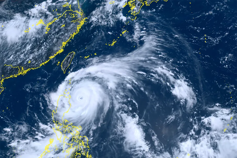
Eastern Taiwan Faces the Highest Forecast Risk
Typhoon Champi strengthened to sustained winds of 55 meters per second as forecasts shifted its path farther west, raising the likelihood that its storm winds would reach Taiwan. The Central Weather Administration's forecast issued on October 18, 2026, put Hualien County's probability of exposure within the next 120 hours at 40%, the highest among the locations listed.
Contents
At 8 a.m., Champi's center was at 13 degrees north latitude and 143.6 degrees east longitude, about 140 kilometers west southwest of Guam and 2,600 kilometers east southeast of Eluanbi, Taiwan's southernmost tip. It was moving generally west toward west northwest at about 19 to 22 kilometers per hour.
The administration expected the storm to approach waters east of Taiwan around October 21 and 22. Northern and eastern Taiwan faced the clearest prospect of heavier rain on October 23 and 24, with rainfall potentially spreading across the island on the latter date.
A sea warning was possible as early as the evening of October 21, although October 22 was the expected timing. A land warning could follow if the storm's wind field approached Taiwan. Its eventual route, including whether it would cross the island, remained uncertain.
Champi Gains Strength and Size
Champi became a strong typhoon on the evening of October 17, according to Central Weather Administration forecaster Liu Pei-teng. By the following morning, its maximum sustained winds near the center had reached 55 meters per second, equivalent to 198 kilometers per hour. Maximum gusts reached 68 meters per second, or about 245 kilometers per hour.
The storm's central pressure was 915 hectopascals. Pressure measures the weight of the atmosphere, and the low pressure at a typhoon's center is one of the measurements forecasters use to assess its strength.
The average radius of Champi's force 7 winds was 200 kilometers, while its stronger force 10 winds extended an average of 100 kilometers from the center. These measurements describe different parts of the wind field: stronger winds occupy a smaller area closer to the eye, while less intense storm winds spread farther out.
Forecasters expected sustained winds could reach 60 meters per second, or 216 kilometers per hour. That would equal the year's highest wind speed recorded for Sinlaku, Bavi and Dolphin, which shared the top position at that point.
How Quickly Has the Storm Changed?
Champi formed on the afternoon of October 15. On October 16, the administration said favorable atmospheric and ocean conditions would support further strengthening, with the possibility that it would eventually become a strong typhoon.
By 2 p.m. on October 17, its sustained winds were 162 kilometers per hour and its storm radius was 180 kilometers. At that time, the center was about 2,980 kilometers east southeast of Eluanbi, moving west at 22 kilometers per hour.
Over the next 18 hours, the reported sustained wind speed rose from 162 to 198 kilometers per hour, an increase of 36 kilometers per hour, or about 22%. The reported storm radius also expanded from 180 to 200 kilometers. Taiwan was therefore monitoring both a stronger storm and a larger area of surrounding winds.
The sequence of observations and forecasts sets out the main dates:
- October 15: Champi formed during the afternoon.
- October 17: Sustained winds reached 162 kilometers per hour by 2 p.m.; the storm became a strong typhoon that evening.
- October 18: Sustained winds reached 198 kilometers per hour at 8 a.m.
- October 21 to 22: Forecasters expected Champi to approach waters east of Taiwan, with a sea warning possible during this period.
- October 23 to 24: The strongest weather effects were expected, particularly rain in northern and eastern Taiwan.
What the Local Probabilities Mean
The administration's 120 hour forecast estimates the chance that a location will fall within the typhoon's storm wind field over five days. Hualien's 40% figure describes that wind exposure risk. Rainfall has its own forecast, shaped by the storm's circulation, its distance from Taiwan and the northeast monsoon.
Yilan followed Hualien at 39%, while Green Island stood at 38%. Taipei and Keelung each had a 36% probability. New Taipei, Taoyuan, Hsinchu City, Hsinchu County, Taitung County and Orchid Island were each listed at 35%.
The figures show a concentration of higher probabilities along Taiwan's eastern side and across the north. Green Island and Orchid Island also featured prominently, placing the offshore islands within the same developing weather threat as eastern Taiwan.
Hualien's probability was five percentage points above the 35% figure for several northern locations. The difference gives a sense of the forecast's geographic pattern, while the wider distribution shows why attention extended beyond a single county.
Central and Southern Taiwan Also Face Exposure
Miaoli, Taichung and Nantou each had a 34% probability of exposure to Champi's storm winds. Changhua and Yunlin were each at 33%, followed by Chiayi County at 32% and Chiayi City at 31%.
Pingtung stood at 30%. The figures for Tainan, Kaohsiung and Pingtung together ranged from 28% to 30%, below the values for the north and east.
The inclusion of Nantou, an inland county, shows how the forecast extended beyond coastal communities. With an average force 7 wind radius of 200 kilometers, Champi had a broad wind field whose reach would depend on the eventual position of its center.
For residents, the useful picture is both local and islandwide: the highest forecast wind probabilities were in the east and north, while central and southern Taiwan also had a measurable chance of exposure. The rainfall outlook broadened further, with rain potentially reaching all parts of Taiwan on October 24.
Why the Turn North Matters
Central Weather Administration forecaster Chang Cheng-chuan said on October 17 that Champi could reach waters off eastern Taiwan on October 22 and then gradually turn north. Some forecast models, however, indicated that a stronger Pacific high pressure system could push the storm farther west and potentially across Taiwan.
A high pressure system is a broad area of air that helps guide the movement of nearby weather systems. For Champi, the strength and position of the Pacific high would help determine how far west it traveled before curving north.
The administration had also identified the storm's movement speed, the eastward retreat of the Pacific high and the southward advance of a continental cold high pressure system as factors affecting its route. Their changing positions made the timing and angle of the turn especially important after October 21.
By October 18, the forecast possibilities still included a turn north near waters northeast of Taiwan, a closer approach to the eastern coast, or a route farther south. Each would place the center and its surrounding winds differently in relation to the island. Forecasters nevertheless expected October 23 and 24 to bring the most pronounced rainfall effects.
Rain Arrives in Stages
Taiwan was expected to have generally fair to cloudy weather through October 20 as moisture decreased. The administration also advised attention to differences between daytime and nighttime temperatures during that relatively settled period.
On October 21 and 22, a strengthening northeast monsoon was expected to bring rain to areas facing the incoming winds from Hsinchu northward. Earlier forecasts also identified eastern Taiwan and the Hengchun Peninsula as places where rain chances would rise.
Northern Taiwan was expected to become cooler and wetter. Temperatures elsewhere were forecast to change less, while southern Taiwan could have brief, localized afternoon showers.
From October 23, Champi's outer circulation could bring localized heavy or very heavy rain to northern Taiwan, Yilan, Hualien and Taitung. On October 24, the area receiving rain could expand across Taiwan. This sequence means rain could begin with the monsoon before the typhoon's larger effects arrived.
Warning Decisions Come Before the Main Rainfall
The administration expected a sea typhoon warning on October 22, with an earlier warning possible on the evening of October 21 if Champi moved faster than forecast. Liu said a subsequent land warning was also possible as the storm approached.
Sea and land warnings address different areas of potential exposure. The forecast placed the first possible warning before the anticipated peak in rainfall on October 23 and 24, giving coastal communities and people planning travel a sequence of dates to watch.
The relatively stable weather through October 20 offered time to check typhoon preparations. From October 21 onward, residents in the north and east faced a changing combination of monsoon rain, a possible sea warning and the approach of Champi's outer circulation. Local wind and rain forecasts would provide the most direct information for individual communities as its track became more precise.
Key Points
- Champi reached sustained winds of 55 meters per second, or 198 kilometers per hour, on October 18, 2026.
- Hualien had the highest forecast probability of storm wind exposure within 120 hours at 40%, followed by Yilan at 39% and Green Island at 38%.
- The storm's force 7 winds extended an average of 200 kilometers from its center.
- A sea warning was possible from the evening of October 21 and expected on October 22, depending on the storm's movement.
- Northern and eastern Taiwan faced the strongest rainfall effects on October 23 and 24, with rain potentially spreading across Taiwan on October 24.
- The timing of Champi's turn north would help determine how closely it approached Taiwan.