
A volcanic triangle joins the island
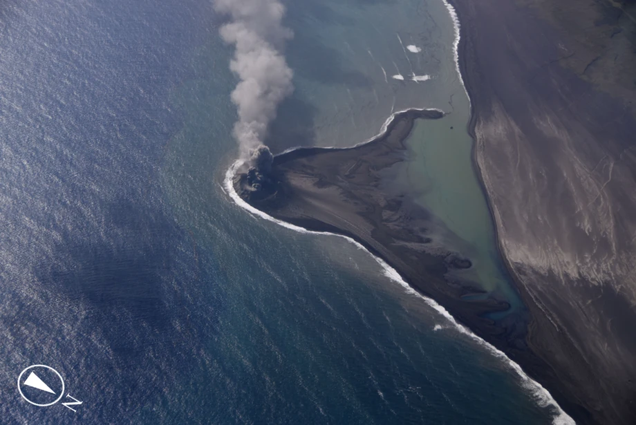
An eruption off the southern coast of Japan's Ioto island has built roughly 50 hectares of new land, satellite image analysis showed on November 17, 2026. The triangular formation, about the size of 10 to 11 Tokyo Domes, has connected to the island as volcanic material piles up above the sea.
Contents
- A volcanic triangle joins the island
- What satellites and aircraft have seen
- How the eruption is building land
- The sequence from renewed activity to a coastal connection
- What instruments detected beneath the visible activity
- Why the 2023 island disappeared
- A changing coast above a much larger volcano
- Warnings remain in place around the active coast
- Key Points
The eruption resumed on October 27 off Okinahama beach in the Ogasawara Islands, which are administered by Tokyo. During a flight on November 13, the Japan Coast Guard observed small, repeated explosions about 700 meters offshore and an eruption plume rising approximately 300 meters.
The Coast Guard's November 16 statement confirmed that the new land extended northward and joined Ioto at its northeastern end. Satellite images taken on November 11 and 16 also showed the connection.
The new coastline is still being shaped by two competing forces: eruptions adding rock and ash, and waves carrying material away. A small island formed nearby during an eruption in 2023 disappeared within months as the sea eroded it. Authorities are continuing observations and maintaining warnings for vessels around the active volcano.
What satellites and aircraft have seen
Europe's Sentinel-2 Earth observation satellite captured gray emissions rising from the sea on October 27. Images from November 11 and 16 then showed a triangular area of land attached to Ioto. Analysis of those images put its area at approximately 50 hectares, equivalent to 500,000 square meters, or half a square kilometer.
The Coast Guard's November 13 flight provided a closer view. An aircraft from the Haneda air base of its Third Regional Coast Guard Headquarters observed the eruption at 24 degrees 45.8 minutes north and 141 degrees 20.1 minutes east. Photographs showed dark new ground beside the sea, with volcanic emissions rising above it.
The aircraft also recorded a small amount of floating material around the formation. Around Ioto's entire coastline, observers saw discolored water ranging from brown and yellowish brown to yellowish green.
The satellite estimate describes how much surface area had emerged, while the aircraft observations show how the eruption was behaving. Together, they document a coastal extension taking shape over several weeks, with material accumulating between the offshore eruption site and the existing island.
How the eruption is building land
Kenji Nogami, a professor at the Institute of Science Tokyo who accompanied the Coast Guard flight, observed continuous grayish black emissions and repeated small explosions. Thermal infrared observations from the aircraft detected hot fragments of lava being thrown out.
Nogami concluded that magma had risen above sea level and that a Strombolian eruption was continuing. This term describes intermittent explosions involving relatively fluid magma. Gas escaping from the molten rock propels fragments into the air, and the falling material can accumulate around the eruption site.
At Okinahama, enough erupted material has collected to rise above the water and extend toward Ioto. Continued explosions can add to that deposit, changing both its outline and its height.
The Japan Meteorological Agency's October activity report records observations from the Maritime Self-Defense Force's Ioto air base unit. It first confirmed the renewed eruption at around 6 a.m. on October 27. From November 6 onward, personnel observed colored eruption plumes rising about 200 to 300 meters, and the agency assessed that erupted material was forming land.
The sequence from renewed activity to a coastal connection
Okinahama has experienced intermittent eruptions since July 2022. The latest observations trace a new episode from its first visible activity in late October to the attached land seen in November.
- October 27, 2026: The Maritime Self-Defense Force confirmed an eruption at around 6 a.m. Sentinel-2 imagery showed gray emissions above the sea.
- October 30: A type of volcanic tremor that had increased sharply after October 27 became continuous.
- November 6 onward: Observers recorded colored plumes approximately 200 to 300 meters high.
- November 11: Satellite imagery showed triangular land connected to Ioto.
- November 13: A Coast Guard flight confirmed the connection, repeated small explosions and hot lava fragments.
- November 16: The Coast Guard published its findings. Another satellite image showed the attached formation.
- November 17: Satellite image analysis put the new land's area at roughly 50 hectares.
The progression from an offshore eruption to a connected landmass took only a few weeks. Its future shape will depend on how much more material the volcano supplies and how quickly the surrounding sea removes it.
What instruments detected beneath the visible activity
The meteorological agency recorded a sharp increase in monochromatic volcanic tremor from October 27. By October 30, the signal was continuous. Volcanic tremor is a sustained vibration of the ground; monochromatic means much of its energy is concentrated around a particular frequency, rather like a persistent note.
Similar signals had accompanied earlier eruptions off Okinahama and at Ioto's Chidorigahama crater. During October, ordinary volcanic earthquakes remained relatively infrequent even as the tremor increased.
Satellite positioning instruments also tracked changes in the island's elevation. Uplift that had continued from November 2025 largely paused after late August 2026, then showed a renewed rising trend around October.
The current episode followed a different pattern from the September 2025 eruption at Chidorigahama. Before that eruption, earthquake activity increased from August 30 and instruments measured a larger than usual rise in the ground. The agency observed no comparable surge in uplift before the latest Okinahama eruption.
Ioto has continued rising over the longer term, although the rate has slowed since around 2024. Scientists therefore monitor several kinds of evidence together: ground movement, earthquakes, tremor, camera images and direct observations of the coast.
Why the 2023 island disappeared
A previous eruption off Ioto produced a small island in autumn 2023. Activity began around October 21, and accumulated volcanic material broke the sea surface on October 30. A Landsat 9 image taken on November 3 captured the new formation offshore.
That island was reported to be about 100 meters wide and as much as 20 meters high. Waves were already eating into its loose volcanic material as the eruption weakened. It disappeared in the following months.
Setsuya Nakada, a professor emeritus of volcanology at the University of Tokyo, explained during the 2023 episode that the formation consisted of piles of pumice that could erode easily. Pumice is volcanic rock filled with small holes left by gas bubbles; some pieces are light enough to float.
Nakada said continued eruptions and lava reaching the surface could help protect parts of the new island. At the time, he also described the possibility of it joining Ioto if activity continued:
"There is a possibility that the (new) island could merge with Iwo Jima if the eruption continues," Nakada said.
The coastal connection documented in November 2026 is now an observed feature. How much of the present formation will survive remains unknown. Its durability will depend on the material deposited and the balance between continued eruption and erosion.
A changing coast above a much larger volcano
Ioto, widely known internationally as Iwo Jima, lies about 1,200 kilometers south of central Tokyo. The meteorological agency's Ioto volcano profile describes an island approximately 8.5 kilometers long from northeast to southwest and 4.5 kilometers wide.
The visible island is the summit region of a much larger underwater volcano. Its base is about 40 kilometers across, and the volcanic structure rises roughly 2,000 meters from the surrounding seabed.
Ioto's existing land also records earlier construction and uplift. Motoyama, the plateau in the northern and central part of the island, contains lava and volcanic deposits that accumulated in shallow water before rising above the sea. Charred wood found in deposits near the northern coast dates some of that material to approximately 2,900 to 2,800 years ago.
The agency describes unusually rapid uplift across the island, hot ground and numerous places where volcanic gas escapes. During eruptions off Okinahama from August to December 2022, observers confirmed material originating from magma for the first time since observations began.
The latest addition is therefore part of a coastline with an active geological history. At Okinahama, new deposits are extending the shore while instruments continue to measure movement of the island itself.
Warnings remain in place around the active coast
The Japan Coast Guard is continuing its navigation warning and urging vessels nearby to exercise caution. The eruption is producing explosions and hot fragments beside a newly formed stretch of coastline.
The meteorological agency has also said it wants to watch the activity closely because large quantities of pumice are drifting in the area. The Coast Guard recorded only a small amount of floating material immediately around the new land during its November 13 flight. The observations cover different views of an area where floating volcanic material can move with the sea.
The agency's October report maintained existing warnings. A warning for areas around the crater has been in place since December 1, 2007, and a marine warning associated with volcanic activity has been in place since April 29, 2012. The report said the warning provisions were unchanged.
For vessels operating nearby, the immediate concern is continuing volcanic activity, drifting material and a changing shore. The agency advises caution along coastal areas and in places where small eruptions have previously occurred. Its next monthly activity report, covering November, is scheduled for December 8, 2026.
Key Points
- Satellite image analysis put the new land off southern Ioto at approximately 50 hectares on November 17, 2026.
- The formation extends northward and connects to Ioto at its northeastern end.
- A November 13 Coast Guard flight observed repeated small explosions, hot lava fragments and a plume about 300 meters high.
- The current eruption resumed on October 27. Volcanic tremor became continuous from October 30.
- A small island formed nearby in 2023 later disappeared through erosion.
- Navigation warnings remain in place. The next monthly volcanic activity report is scheduled for December 8.