Flooded roads and power cuts as the storm closes in
Typhoon Champi was about 180 kilometers south of Ishigaki Island at 10 a.m. on October 23, 2026, as Okinawa's southern islands faced destructive winds, flooding and the threat of repeated downpours through dawn on October 24. Roads in Miyakojima were already flooded that morning, while 3,630 households, mainly in the Yaeyama region, had lost electricity.
Contents
- Flooded roads and power cuts as the storm closes in
- How strong is Champi?
- Why the rain warning is especially serious
- Coastal communities face waves and rising water
- What the official alert levels mean
- Where residents and visitors can shelter
- Travel, schools and public events disrupted
- Kyushu and Honshu face a later rain threat
- The main dates to watch
- Key Points
A woman in Miyakojima suffered a serious injury involving a fracture. The circumstances of her injury were not detailed. Across the islands, schools closed, evacuation shelters opened and hundreds of flights and ferry services were canceled or expected to be canceled.
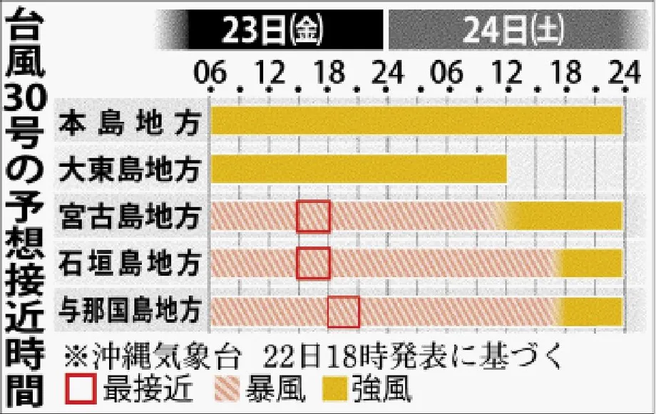
The Okinawa Meteorological Observatory issued storm warnings for the Yaeyama and Miyakojima regions. The warnings covered the Ishigaki Island, Yonaguni Island and Miyakojima areas, with a Level 4 storm surge danger warning also in effect for the Ishigaki Island area. Forecasters expected Champi, Japan's 30th typhoon of the year, to come closest to the Ishigaki and Miyakojima areas during the evening of October 23, then to the Yonaguni area early that night.
The immediate concern was a combination of hazards: powerful winds, seas reaching 12 meters, rising coastal water levels and narrow bands of thunderstorms capable of pouring rain onto the same places for hours. The Japan Meteorological Agency warned that the danger of rain disasters could increase rapidly from the afternoon of October 23 through dawn the following day.
How strong is Champi?
At 10 a.m. on October 23, Champi was moving north northwest at 15 kilometers per hour. Its central pressure was 955 hectopascals, with maximum sustained winds near the center of 40 meters per second and gusts reaching 60 meters per second. Those wind speeds equal about 144 and 216 kilometers per hour, respectively.
The distinction matters for residents: sustained wind describes the continuing force, while a gust is a shorter burst that can be much stronger. Forecasters warned that some houses could collapse under the strongest winds.
The prefectural forecast called for gusts up to 198 kilometers per hour on October 23 and 180 kilometers per hour on October 24. Local forecasts for Ishigaki and Yonaguni also included gusts of 60 meters per second, or 216 kilometers per hour. These figures describe different areas and forecast periods, while the measurements near the center describe the storm itself.
Champi had been stronger the previous afternoon. At 3 p.m. on October 22, its central pressure was 925 hectopascals, sustained winds were 50 meters per second and gusts reached 70 meters per second. By 5 a.m. on October 23, central pressure was 950 hectopascals. Lower central pressure generally accompanies a more intense tropical cyclone.
The storm's size also mattered. An October 22 bulletin put winds above 25 meters per second as far as 390 kilometers northeast and 280 kilometers southwest of the center. Parts of the Sakishima Islands, which include Miyako and Yaeyama, were expected to remain within the storm wind area for more than a full day.
Why the rain warning is especially serious
The Miyakojima and Yaeyama regions faced the possibility of linear rainbands from the afternoon of October 23 through dawn on October 24. A linear rainband is a narrow chain of rain clouds that repeatedly moves over the same area. Rain can keep accumulating in one place even while nearby communities receive much less.
The Japan Meteorological Agency forecast up to 250 millimeters of rain in Okinawa during the 24 hours ending at 6 a.m. on October 24, followed by up to another 120 millimeters during the next 24 hours. Local totals could be higher if rainbands formed. A Yaeyama forecast also projected as much as 250 millimeters through noon on October 24.
The two successive prefectural forecast amounts add to 370 millimeters, or 37 centimeters of rain, although the largest amounts in each period could fall in different places. Earlier forecasts had put rainfall at up to 200 millimeters and then 150 millimeters across successive periods, showing how the expected timing and amounts changed as the storm approached.
Heavy rain had already set October records on October 22. One hour brought 58 millimeters at Gusukube Aragusuku in Miyakojima, 51 millimeters at Miyako Airport and 61 millimeters at Yomitan on Okinawa's main island. Each was the highest October hourly rainfall recorded at that observation site.
Flooding on some Miyakojima roads the following morning made the danger immediate. Weather officials urged strict caution around slopes vulnerable to landslides, low ground where water collects, and rivers that could rise or overflow. They also urged people to follow successive weather alerts and Kikikuru, the agency's maps showing changing disaster risk.
Coastal communities face waves and rising water
Waves could reach 12 meters around Okinawa on October 23 and 24. Forecasts also included waves up to six meters around Amami, farther north. Local weather offices described extremely rough seas around Miyako and Yaeyama, with dangerous swell extending beyond the islands closest to the center.
Yaeyama faced a particular storm surge risk from the afternoon of October 23 into early that night. A storm surge occurs when a storm's winds and low air pressure raise the sea above its usual level. Large waves arriving on top of that higher water can flood coastal ground and damage waterfront facilities.
Ishigaki City told visitors to stay away from beaches and river mouths. For people living near the shore or an estuary, flooding could come from the sea as well as from heavy rain inland.
The strongest effects were concentrated in the Sakishima Islands, but conditions varied across the prefecture. Okinawa's main island was forecast to have rough weather and possible thunderstorms through October 24. The Daito Islands were expected to become mostly sunny on October 24, while strong winds during the morning and rough seas continued.
What the official alert levels mean
The Japan Meteorological Agency's Miyako and Yaeyama warnings, issued at 2 p.m. on October 23, set out categories for heavy rain, landslides and storm surge, alongside the actions associated with alert levels. Residents need to check the announcement for their own location because the required action depends on the local danger.
At Level 2, people should confirm their evacuation plans. At the equivalent of Level 3, older people, people with disabilities and anyone else who needs more time should evacuate from affected areas. At the equivalent of Level 4, all residents should evacuate from affected areas.
The agency gives its most urgent instruction for conditions equivalent to Level 5, when danger to life is already extreme:
Life-threatening situation, ensure safety immediately!
Okinawa Prefecture established its disaster response headquarters on the morning of October 22. Governor Genta Koja urged residents to confirm evacuation locations and prepare for violent weather, electricity failures and interruptions to water supplies. He also called for particular care near the coast.
Where residents and visitors can shelter
Municipalities across Yaeyama opened shelters after storm warnings were issued at about 4:10 p.m. on October 22. Ishigaki opened its Health and Welfare Center for general use and Yui Heart Center for people needing assistance. Taketomi opened 17 locations across its islands, while Yonaguni opened the Sonai Health Center.
Ishigaki City's notice for visitors had urged tourists to secure a safe place during daylight on October 22. The notice initially anticipated a storm warning late that night; the warning was subsequently issued during the afternoon.
The city asked visitors to remain at their accommodation whenever possible and to finish any move between properties before conditions deteriorated. It explained that public shelters were available to tourists as well as residents, but had limited capacity and supplies:
Public evacuation shelters (such as the Health and Welfare Center) are open to everyone, but space and supplies are limited.
People using a shelter were asked to bring food and drinking water. The city also warned that supermarkets and convenience stores might close temporarily and that power cuts could occur. Visitors with rental cars were advised to contact their rental company about returning vehicles early because strong winds could damage them.
Weather offices advised people to move into sturdy buildings and stay away from windows indoors. With roads flooding and winds strengthening, the city's earlier instruction to arrange accommodation before the storm had direct consequences for anyone still considering a move.
Travel, schools and public events disrupted
At least 87 flights and 198 ferry services were canceled on October 22. Another 111 flights and 148 ferry services were expected to be canceled on October 23, cutting connections between islands and disrupting journeys to and from Okinawa.
Together, those figures amount to at least 198 flights and 346 ferry services canceled or expected to be canceled across the two days. The October 23 figures were still forecasts, so travelers needed to check individual services with their operators.
Airlines had also flagged possible disruption across October 23 and 24 at airports including Naha, Miyako, Ishigaki and several Amami islands, with some services involving Taiwan affected. Ishigaki City directed passengers to their own airline or ferry company for current operating information.
The Miyakojima and Tarama boards of education decided to close schools on October 23. Public events were affected too: the Kin Town folk performing arts festival scheduled for October 24 was canceled.
The 19th Times Community Contribution Awards ceremony, due to take place at Times Hall on October 24, was postponed until November 8. Organizers therefore provided a replacement date rather than leaving participants waiting for a further announcement.
Kyushu and Honshu face a later rain threat
Forecasts placed Champi in the East China Sea on October 25, followed by a possible approach to or landfall on Kyushu around October 26. Another projected route took the weakening storm toward the Tsushima Strait, between Kyushu and the Korean Peninsula, before it turned east. The exact route and any landfall location remained uncertain.
Rain was expected to spread ahead of the center. A front stretching across western and eastern Japan was forecast to draw in warm, moist air from around the typhoon. A front is a boundary between air masses; the extra moisture can feed heavier rain along it.
Kyushu was forecast to receive rain and thunderstorms from around midday on October 23, with Shikoku following from the evening. Rain was expected from Kyushu to Kanto on October 24, including locally intense downpours in western Japan.
Forecasters warned of rain heavy enough to trigger warnings from Kyushu through Kanto on October 25 and 26, with the risk extending into October 27. Champi was expected to weaken and later change into an extratropical low as it moved toward western and eastern Japan. Such a system draws energy from temperature differences between air masses, and can still bring damaging rain.
The main dates to watch
The emergency began before Champi's closest approach. Rainfall records, shelter openings and transport cancellations on October 22 were followed by flooding and electricity failures on October 23.
The next forecast stages extended from the southern islands to Japan's larger population centers:
- October 22: Okinawa established its disaster headquarters, Yaeyama municipalities opened shelters, and heavy rain set October hourly records at three observation sites.
- October 23: Champi was forecast to pass closest to Ishigaki and Miyakojima in the evening, then Yonaguni early at night, with destructive winds and storm surge risks.
- Through dawn on October 24: Miyakojima and Yaeyama faced the possibility of linear rainbands and a rapid increase in rain disaster risk.
- October 25 to 27: The storm was forecast to move north and east, with a possible Kyushu approach around October 26 and heavy rain risks extending toward Kanto.
- November 8: The postponed community contribution awards ceremony was scheduled to take place.
Key Points
- Champi was 180 kilometers south of Ishigaki at 10 a.m. on October 23, with gusts near its center reaching 60 meters per second.
- Miyakojima roads had flooded, a woman suffered a fracture, and 3,630 households had lost power, mainly in Yaeyama.
- Linear rainbands could bring prolonged downpours through dawn on October 24, while waves could reach 12 meters.
- Evacuation shelters opened across Yaeyama; Ishigaki asked visitors to remain in safe accommodation whenever possible.
- Hundreds of flights and ferry services were canceled or expected to be canceled, and schools closed in Miyakojima and Tarama.
- A possible Kyushu approach around October 26 was followed by a forecast of heavy rain extending toward Kanto through about October 27.