
A stalled negotiating channel returns to the agenda
Nepal and India have 182 jointly prepared boundary maps awaiting endorsement, a political negotiating mechanism agreed in 2014 that has never met, and competing claims over the source of the river defining Nepal's western frontier. Former diplomats want Prime Minister Balendra Shah to address those unfinished tasks when he meets Indian Prime Minister Narendra Modi during a proposed November 22–25 visit.
Contents
- A stalled negotiating channel returns to the agenda
- Why the Kali River is central
- Technical teams have a different job
- The 2014 agreement still awaits a meeting
- How maps and roads intensified the dispute
- Shah's parliamentary remarks raised the stakes
- Lipulekh brings China into the equation
- Preparation includes finding the documents
- Economic needs will compete for attention
- Flood recovery and air access add urgency
- Earlier settlements show the work involved
- Key Points
The trip, expected to be Shah's first official bilateral visit abroad since taking office in March 2026, would bring territorial disputes into talks also covering a roughly Rs 952 billion trade deficit, electricity exports and a proposed $2 billion assistance package. Neither government has formally announced the itinerary.
Nepal's Foreign Ministry has already confirmed an exchange of diplomatic notes over the Kailash Mansarovar pilgrimage route through Lipulekh. Its boundary clarification statement, dated May 31, 2026, says both countries have committed to resolving border disputes through diplomacy and mutual discussion. It also says joint technical teams are collecting boundary records again after a prolonged interruption.
That creates two immediate tasks for Shah: seek political negotiations over disputed territory, while supporting technical work on boundary pillars and land used by people across the border. Those processes involve different problems and different officials.
Nilamber Acharya, a former Nepali ambassador to India and member of the Eminent Persons' Group established to review bilateral relations, wants the visit to produce an explicit commitment to talks.
"Some problems may not be resolved overnight, but the border issue should not be left pending. The prime minister must clearly say that dialogue needs to begin," he said.
Why the Kali River is central
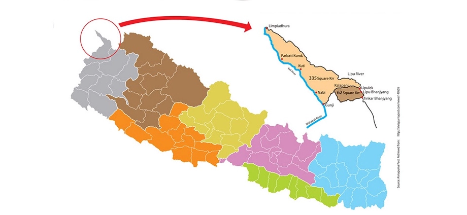
The 1816 Treaty of Sugauli provides the central legal reference for Nepal's western boundary. Article 5 required Nepal to renounce claims west of the Kali River, also called the Mahakali. Identifying where that river begins determines which side of the boundary the disputed mountain territory falls on.
Nepal maintains that the river originates at Limpiyadhura. Under that interpretation, Limpiyadhura, Kalapani and Lipulekh lie within Nepal. India places the source at springs below the Lipulekh region and cites administrative and revenue records connecting Kalapani to Pithoragarh, now in Uttarakhand. Indian security forces are stationed in Kalapani.
The treaty does not explicitly name Limpiyadhura as the source, and no map jointly authenticated by the parties defining that source is known to have accompanied it. Historical maps, river evidence and records of administration therefore sit at the centre of the competing arguments.
Susta is another acknowledged area of disagreement. Former diplomats argue that Shah needs a prepared position on both disputes, supported by documents that officials can examine across a negotiating table.
Technical teams have a different job
Nepal's Foreign Ministry identifies unresolved mapping in Susta and the Limpiyadhura, Lipulekh and Kalapani areas. Elsewhere along the approximately 1,880 kilometre border, it describes problems involving occupation across the boundary, encroachment into the border strip, and missing or damaged pillars.
The ministry explains that a fixed boundary principle has been applied in river sections. In simple terms, the agreed boundary stays in place even when a river changes its course. People may consequently cultivate or occupy land that falls across the international boundary.
Joint technical teams are recording those situations and working on pillar construction, repairs and encroachment. The ministry says their studies indicate that some land used from Nepal may fall in India, while some land used from India may fall in Nepal.
Acharya argues that officials must define these practical land use problems separately from competing claims to territory. Technical records can help determine who occupies a parcel and where a pillar belongs; the unresolved territorial claims require diplomatic negotiations.
The 2014 agreement still awaits a meeting
Modi and then Nepali Prime Minister Sushil Koirala agreed during Modi's August 2014 visit to give the foreign secretaries responsibility for unresolved boundary issues. Their August 4 joint statement specifically identified Kalapani and Susta, with technical support from the Boundary Working Group when needed.
The mechanism led by the foreign secretaries never held a meeting. Acharya believes regular discussions could have contained disagreements before they became larger political confrontations.
Technical engagement has followed a different course. Survey officials and the Boundary Working Group have met over the past two years, and repairs to boundary pillars have begun. Former Indian ambassador to Nepal Naveen Srivastava has argued for sustaining that practical work alongside economic cooperation.
The 182 strip maps illustrate the unfinished business. A strip map is a detailed map of a section of the boundary. The two countries prepared these jointly, but formal endorsement remains pending because of Kalapani and Susta. Border specialists estimate that endorsing them could resolve around 98 percent of boundary issues. That estimate concerns the extent of problems addressed, rather than a measured settlement of 98 percent of disputed territory.
How maps and roads intensified the dispute
The present dispute has accumulated through agreements, maps and construction projects over more than a decade. Several events explain why a dormant negotiating channel now carries such political weight.
- August 4, 2014: Nepal and India assigned unresolved boundary issues, including Kalapani and Susta, to their foreign secretaries.
- 2015: Nepal protested to India and China after they agreed to use Lipulekh for trade without consulting Kathmandu.
- November 2019: Nepal objected to the Survey of India's seventh edition political map, which placed the disputed western areas within India.
- May 2020: Indian Defence Minister Rajnath Singh inaugurated a road to Lipulekh, prompting another Nepali protest. Nepal issued a revised map claiming Limpiyadhura, Lipulekh and Kalapani.
- June 2020: Nepal's Parliament approved the constitutional amendment incorporating the revised map into the national emblem.
- May 31, 2026: Shah addressed the boundary dispute in Parliament, and Nepal's Foreign Ministry issued its explanation of occupation across the border.
Nepal's diplomatic exchanges over the 2019 map have been described both as three unanswered notes and as an Indian rejection received after more than three weeks. The current position is more definite: Nepal's Foreign Ministry confirms that India answered the recent Lipulekh pilgrimage note through the same diplomatic channel.
Shah's parliamentary remarks raised the stakes
Shah faced opposition protests after his May 31 response to CPN-UML lawmaker Padma Aryal about an India–China route agreement. He said that, after becoming prime minister, he had learned Nepal had also occupied considerable Indian territory.
Foreign Minister Shishir Khanal subsequently explained that Shah was referring to occupation across the boundary and encroachment in the border strip. Parliamentary proceedings resumed, although the opposition's demand to remove the remarks from the record was not accepted.
The Foreign Ministry's explanation tied the remarks to technical surveys and land use across a fixed boundary. It reaffirmed Nepal's commitment to negotiations based on historical treaties, agreements and maps.
Shah later told the Rastriya Swatantra Party convention in Chitwan that Nepal possessed evidence supporting its claims to Kalapani and Lipulekh. His public association with territorial maps predates his premiership: as Kathmandu mayor in 2023, he displayed a Greater Nepal map amid controversy over an Akhand Bharat mural in India's new Parliament building.
Lipulekh brings China into the equation
Lipulekh is a route toward Mount Kailash and Lake Mansarovar in Tibet, making it relevant to pilgrims as well as trade. India says the pilgrimage route has been used since 1954. Nepal maintains that the pass lies within its territory.
India and China agreed in April to reopen the pilgrimage route. India's April 30 announcement for the 2026 season envisaged 20 pilgrimage groups, including 10 travelling through Lipulekh. Nepal subsequently sent diplomatic objections to both neighbours.
Indian Foreign Ministry spokesperson Randhir Jaiswal has defended the route's longstanding use and rejected Nepal's territorial claim while keeping open the possibility of bilateral dialogue. Nepal's ministry says both sides have expressed a commitment to diplomatic discussion.
Border specialist Buddhi Narayan Shrestha wants Shah to prioritise identifying the western tri-junction, the point where Nepal, India and China meet. Nepal and China could not establish that point without India's participation. Its unresolved location repeatedly draws China into disagreements centred on Lipulekh.
Former prime minister Baburam Bhattarai also proposes cooperation among the three countries on Himalayan climate risks. He suggests that separate agreements between each pair of neighbours could help build an understanding if joint talks among all three are difficult to arrange.
Preparation includes finding the documents
Former ambassador Dinesh Bhattarai has questioned whether the government has conducted sufficiently broad consultations before the visit. He wants Shah to understand the competing claims and carry supporting evidence into talks at the highest political level.
Nepal also faces an archival problem. Foreign Minister Khanal told Parliament that the government could not confirm whether treaty documents in its possession were the official originals. A parliamentary inquiry searched libraries, archives, ministries and museums without locating the original Sugauli Treaty or the 1950 Treaty of Peace and Friendship.
Khanal said Nepal holds documents relating to both treaties. In 2019, then foreign minister Pradeep Gyawali had similarly said copies required forensic verification and that Nepal was seeking historical documents and maps in India and the United Kingdom.
The wider relationship has another unfinished document: the Eminent Persons' Group report completed in 2018, which has yet to be formally submitted to both prime ministers. Former foreign and finance minister Prakash Sharan Mahat wants Shah to pursue its submission and a review of provisions of the 1950 treaty that Nepal regards as unequal.
Baburam Bhattarai favours a comprehensive mechanism covering the boundary, trade, transit, water resources and the treaty. His proposal would bring inherited disputes into a continuing process rather than leave each new government to restart the discussion.
Economic needs will compete for attention
India accounts for more than 63 percent of Nepal's foreign trade. Nepal Rastra Bank figures cited for fiscal year 2025/26 put the trade deficit at Rs 951.95 billion, with imports of approximately Rs 1,210 billion and exports of Rs 258.65 billion. Imports were roughly 4.7 times exports.
Mahat argues that Nepal needs stronger production and easier market access, including simpler customs procedures and recognition of product quality certificates. He identifies agriculture, herbs, tea, coffee, cardamom, processed food, cement and electricity as areas with export potential.
Electricity already provides a substantial connection. Nepal exports close to 1,200 megawatts to India during the wet season, against an agreement targeting 10,000 megawatts over 10 years. The current seasonal figure is about 12 percent of that target. Kathmandu wants more transmission capacity, dependable buyers and progress on projects including Pancheshwar and Lower Arun.
Digital payments present a smaller but tangible unfinished task. An agreement between the National Payments Corporation of India and Nepal Clearing House Ltd on May 31, 2023, sought to connect payment systems. Indian visitors can make QR payments in Nepal, while merchant payments by Nepalis in India remain unresolved.
Existing transfer arrangements allow Indian citizens to send up to INR 15,000 per transaction and INR 100,000 monthly. Transfers into Nepali bank accounts can reach INR 200,000 per transaction. Nepal Rastra Bank says arrangements for merchant payments and digital transfers from Nepal to India remain under development.
Flood recovery and air access add urgency
Kathmandu is preparing to seek approximately $2 billion in Indian assistance for reconstruction and infrastructure, potentially through grants and concessional loans. The request follows the August 26 floods in the Bhotekoshi–Rasuwa corridor; another description of the proposal refers to damage from September floods.
The economic effects extend to tourism and transport. Nepal's fall in Indian arrivals in October followed flood damage and disrupted pilgrimage routes. Kathmandu also wants additional air entry routes to help the international airports at Bhairahawa and Pokhara operate closer to capacity.
Indian Foreign Secretary Vikram Misri visited Kathmandu on November 4–5 to discuss possible outcomes for Shah's trip, following the preparations for Misri's visit earlier that month. His meetings covered trade, energy, connectivity, development cooperation and border management.
Jaiswal, speaking as India's Foreign Ministry spokesperson, described the intended scope of the prime ministerial talks:
"The entire range of bilateral relations that we have with Nepal will be discussed. This is an expansive partnership. This is a very special partnership, and all matters of mutual interest would be discussed," he said.
Earlier settlements show the work involved
India and Bangladesh implemented their Land Boundary Agreement in 2015 after decades of negotiations. India received 7,110 acres and Bangladesh 17,160 acres through the settlement of enclaves and territorial boundaries. The original agreement dated to 1974, a gap of 41 years before implementation.
Nepal's own boundary negotiations with China provide another example cited by former diplomats. After diplomatic relations began in 1955, Prime Minister BP Koirala held five rounds of discussions with Chinese Premier Zhou Enlai. The countries signed their boundary treaty on October 5, 1961, following resolution of their disagreement over Mount Everest.
Dinesh Bhattarai credits Koirala's preparation, including explaining Nepal's position with maps at the negotiating table. For Shah, the immediate opportunity is similarly practical: secure agreement to hold political talks, keep technical surveys moving and assign officials responsibility for unfinished decisions.
Key Points
- Shah's proposed India visit is expected on November 22–25, with the itinerary awaiting formal announcement.
- A mechanism agreed in 2014 to address Kalapani and Susta has never met.
- Nepal's Foreign Ministry confirms that technical boundary work has resumed and India answered its recent Lipulekh note.
- Formal endorsement of 182 jointly prepared strip maps remains pending.
- Nepal claims the Kali River begins at Limpiyadhura; India places its source elsewhere.
- Trade, electricity, air routes, digital payments and a proposed $2 billion assistance package are also expected on the agenda.