Red warning covers eastern waters as depression strengthens
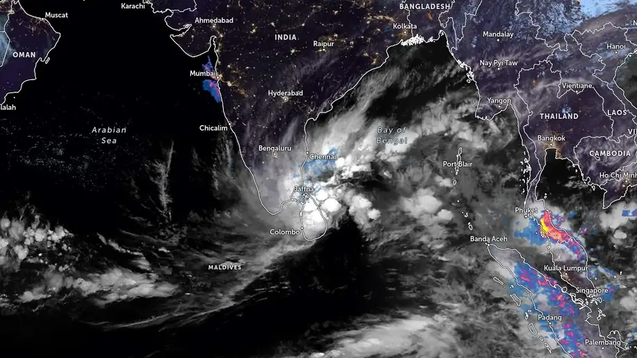
Sri Lanka's Department of Meteorology has warned fishing and naval communities to avoid a broad stretch of the Bay of Bengal as a depression northeast of Trincomalee is forecast to become a severe cyclonic storm by November 17. The warning covers both deep sea waters and offshore areas extending from Kankesanthurai to Hambantota through Trincomalee and Pottuvil.
Contents
- Red warning covers eastern waters as depression strengthens
- Where boats have been told to stay away
- How the forecast develops through November 19
- What the different storm categories mean
- Rain forecast extends across much of Sri Lanka
- Lightning, brief strong winds and morning mist
- What fishing communities need to watch next
- Key Points
The department's special advisory, issued at 11:30 a.m. on November 15, placed the depression approximately 600 kilometres northeast of Trincomalee at 5:30 a.m. It was moving northwest, with a northward component, and was expected to remain well off Sri Lanka's eastern coast while gaining strength.
The forecast sets out several stages of development: a deep depression by the morning of November 16, a cyclonic storm by that evening or night, and a severe cyclonic storm over the west central Bay of Bengal by November 17. Projections extend to November 19, when the system could become a very severe cyclonic storm.
The immediate instructions concern vessels already exposed to strong winds and rough seas. Crews operating in the affected waters have been told to move to safe locations, while those preparing to depart have been advised to stay out until further notice. Boats making fishing trips lasting several days are specifically covered by the red warning.
Where boats have been told to stay away
The marine warning identifies waters between 5 and 15 degrees north latitude and 80 and 90 degrees east longitude. Latitude measures position north or south of the equator, while longitude measures position east or west around the globe. Together, these coordinates mark the area crews need to check against their intended routes.
The department also names the offshore stretch from Kankesanthurai in the north to Hambantota in the south, passing Trincomalee and Pottuvil along the eastern side of the island. This coastal description gives crews a second way to identify the affected waters alongside the coordinates.
The advice to avoid these areas was stated to apply from 5:30 a.m. on November 14 until further notice. The red warning issued on November 15 carries a bulletin validity period ending at 11:30 a.m. on November 16. The instruction governing fishing and naval activity continues until the department changes it.
For vessels already offshore, the department's direction is to move to safer areas immediately. A boat's intended fishing grounds and its route through the warned waters both matter when deciding whether a voyage would enter the affected area.
How the forecast develops through November 19
The department expects the depression to strengthen while moving across the Bay of Bengal, farther from Sri Lanka. Its forecast places the developing cyclonic storm over the southern and adjoining west central Bay by November 16, followed by a severe cyclonic storm over the west central Bay on November 17.
The sequence of observations, warning periods and projected changes is:
- November 14, 5:30 a.m.: The stated starting time for advice to avoid the specified sea areas.
- November 15, 5:30 a.m.: The depression was approximately 600 kilometres northeast of Trincomalee.
- November 15, 11:30 a.m.: The special marine warning was issued. A subsequent weather update placed the depression approximately 630 kilometres northeast of Trincomalee at this observation time.
- November 16, morning: The system is forecast to become a deep depression.
- November 16, 11:30 a.m.: The stated validity period of the November 15 red warning ends, with crews instructed to follow subsequent bulletins.
- November 16, evening or night: The system could become a cyclonic storm over the southern and adjoining west central Bay of Bengal.
- November 17: Severe cyclonic storm strength is forecast over the west central Bay.
- November 18: The system could retain severe cyclonic storm strength.
- November 19, morning: It could strengthen further into a very severe cyclonic storm.
Earlier forecasts placed possible storm formation near the central Bay of Bengal on November 16. The more detailed November 15 advisory specifies the southern and adjoining west central Bay that evening or night. No landfall location or time was given.
What the different storm categories mean
A depression is an organised weather system built around an area of low atmospheric pressure. Air moves toward the lower pressure and circulates around it. Deep depression, cyclonic storm, severe cyclonic storm and very severe cyclonic storm are successive categories used to describe increasing wind strength.
The November 15 observation identified the system as a depression. The stronger categories describe its expected development over the following days. The department's immediate marine advice therefore applies before the system reaches the severe storm stage forecast for November 17.
The movement of the centre and the conditions around it also need to be understood together. The centre is forecast to travel farther from Sri Lanka, while the department continues to warn of dangerous winds and rough seas across the specified waters. Crews need the marine warning for their operating area as well as the forecast position of the storm.
The November 19 projection gives the longest forecast horizon described in the warning. The department says it is monitoring both movement and development, and has asked fishing and naval communities to remain attentive to later forecasts and bulletins as the system evolves.
Rain forecast extends across much of Sri Lanka
Sri Lanka's weather forecast also points to cloudy skies across the island and rain in several provinces under the influence of the Bay of Bengal system. The November 15 forecast called for periods of rain in the Northern, North Central and Eastern provinces, with frequent rain in the Western and North Western provinces and in Galle and Matara districts.
The forecast for November 16 extends several spells of showers to the Northern, North Central, Eastern, Western, Sabaragamuwa and North Western provinces. Kandy, Nuwara Eliya, Galle and Matara districts are also included.
Uva Province and Hambantota district could experience showers or thundershowers at a few places after 2:00 p.m. on November 16. This gives residents there a more specific period to watch than the broader forecast of cloudy skies and intermittent showers elsewhere.
The regional detail matters because the forecast varies across the country. Northern and eastern areas are among those expecting spells of rain, while some southern and southeastern locations face the possibility of thunderstorms later in the day. The marine warning operates alongside these forecasts for conditions on land.
Lightning, brief strong winds and morning mist
The Department of Meteorology has advised the public to take precautions against temporary localised strong winds and lightning during thundershowers. These winds can arrive abruptly near a thunderstorm and affect a smaller area than the wider weather system.
For people working outdoors, travelling or taking boats through coastal waters, the thunderstorm forecast adds a more immediate hazard to watch during the day. Lightning and sudden gusts are specifically named in the department's advice for November 16.
Misty conditions are expected in most parts of the island during the early morning of November 16. The preceding forecast also identified possible early morning mist in the Western, Sabaragamuwa, Central and Uva provinces, as well as Galle, Matara and Kurunegala districts.
Mist can reduce visibility at the start of the day, while showers and possible thunderstorms affect later periods. Residents therefore face several kinds of weather over the same day, with the timing and location of each set out in the regional forecast.
What fishing communities need to watch next
Fishing crews face two immediate decisions: whether to begin a voyage through the warned waters, and where to move if already operating there. The department's advice is to avoid the specified areas until further notice and for vessels inside them to seek safe locations.
Boats remaining at sea for several days are specifically addressed because their operations extend across the period when the depression is forecast to strengthen. A voyage starting while the system is a depression could continue into the period forecast for cyclonic storm or severe cyclonic storm conditions.
The next dated checkpoint is 11:30 a.m. on November 16, the end of the stated validity period for the November 15 bulletin. Crews have been instructed to consult subsequent forecasts and warnings, while the wider advice to avoid the affected waters remains in place until further notice.
The key developments to watch are whether the system becomes a deep depression on November 16, where it reaches cyclonic storm strength later that day, and whether it reaches the severe category on November 17. Each stage will inform later marine warnings as the department tracks the system's position and strength.
Key Points
- The depression was about 600 kilometres northeast of Trincomalee at 5:30 a.m. on November 15.
- It is forecast to become a cyclonic storm on November 16 and a severe cyclonic storm by November 17.
- Forecasts indicate possible further strengthening into a very severe cyclonic storm by the morning of November 19.
- Fishing and naval communities should avoid the specified Bay of Bengal waters and offshore areas from Kankesanthurai to Hambantota via Trincomalee and Pottuvil until further notice.
- Vessels already in affected waters have been advised to move to safe locations.
- Much of Sri Lanka is forecast to experience cloudy skies and showers, with localised strong winds and lightning possible during thunderstorms.
- The department has asked marine communities to follow subsequent forecasts and warnings.