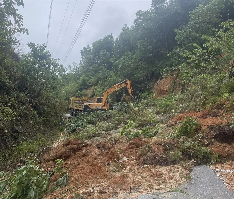
Flood danger shifts south as rivers rise
Hue recorded 611.4 millimeters of rain at Hong Trung in the 24 hours to 6 a.m. on November 10 as flooding, landslides and powerful coastal waves disrupted central Vietnam. Reservoir operators increased releases, mountain roads became impassable and authorities moved families away from unstable slopes.
Contents
- Flood danger shifts south as rivers rise
- Rainfall exceeded 600 millimeters in Hue
- Thanh Hoa's river kept rising after rain eased
- Mountain roads close in Hue and Quang Tri
- Families move out and schools suspend classes
- Hue releases water while Da Nang reservoirs store it
- Fallen trees threaten streets and homes in Da Nang
- Waves push into coastal homes
- The next critical dates
- Key Points
In Thanh Hoa, the Yen River at Chuoi station reached 4.47 meters at 5 p.m. on November 9, almost one meter above warning level 3. Farther south, six crossings in Dakrong Commune, Quang Tri, were submerged under 2 to 2.5 meters of water by November 10. In coastal Hue, waves reaching 2 to 4 meters washed seawater into homes and damaged the shoreline.
The National Center for Hydro-Meteorological Forecasting expected the main rain belt to move south, with another 150 to 280 millimeters over two days from Hue to eastern Gia Lai, and more than 450 millimeters in some places. Heavy rain was expected to ease from November 12, although river flooding remained a concern through that date.
Residents faced several different dangers at once: rising rivers, water rushing down mountain slopes, falling trees in cities and seawater entering coastal neighborhoods. Those conditions also complicated the response. In Da Nang, firefighters had to carry equipment about 300 meters through a narrow alley to reach a fallen tree threatening two homes.
Damage figures were still being updated. A rapid disaster assessment issued at 5 p.m. on November 9 recorded flooded crops, livestock losses and damaged infrastructure in Thanh Hoa, while subsequent updates described fresh evacuations, school closures and road blockages in Hue, Quang Tri and Da Nang.
Rainfall exceeded 600 millimeters in Hue
Hong Trung's 611.4 millimeters was among the largest totals in the national weather center's warning issued at 6:30 a.m. on November 10. Over the same 24 hours, Ky Lac in Ha Tinh recorded 523 millimeters, Huong Son in Quang Tri 412 millimeters and Ba Na 1 in Da Nang 449.2 millimeters.
Rainfall measures how much water would collect on a flat surface before running away or soaking into the ground. A total of 611.4 millimeters means about 611 liters of water fell on each square meter at that measuring point. Flood depth depends on where that water subsequently flows and collects.
Shorter observation periods showed how intense the downpours became. Huong Phu in Hue recorded 567.6 millimeters between 7 p.m. on November 9 and 3 a.m. on November 10. During the six hours ending at 4 a.m., Khe Tre received 250.4 millimeters, Huong Son in Hue 207.8 millimeters, Hong Thai 177.8 millimeters and A La reservoir 177.4 millimeters.
Heavy rain also extended farther south. In the 12 hours to 6 a.m. on November 10, Song Hinh 4 in Dak Lak recorded 309.1 millimeters, Canh Lien in Gia Lai 145.8 millimeters, Khanh Trung in Khanh Hoa 145.3 millimeters and Son Tay in Quang Ngai 102.4 millimeters.
Cold air had reached central Vietnam and parts of the southern central coast by November 10. Temperatures from Thanh Hoa to Quang Tri were forecast to fall to 15 to 18 degrees Celsius, adding cold conditions to the disruption caused by rain and wind.
Thanh Hoa's river kept rising after rain eased
Thanh Hoa received widespread rainfall of 100 to 200 millimeters from the night of November 8 through the morning of November 9. Thanh Tan 1 recorded 458 millimeters and Nhu Xuan 426 millimeters. Rain eased around 10 a.m., but the Yen River continued rising as water drained into it.
Forecasters initially expected the river at Chuoi to crest at 4.55 to 4.65 meters that evening, about 1.05 to 1.15 meters above warning level 3. The warning levels are river gauge thresholds used to guide flood preparations. By November 10, the river was forecast to fall below level 3 that evening.
Flooding blocked 12 locations on provincial roads and 35 crossings on local roads. An approach to a bridge on the Nghi Son-Bai Tranh route in Thanh Ky Commune subsided, stopping traffic. Provincial Road 505B suffered a landslide, and two crossings in Yen Tho Commune were damaged.
Water breached a 50 meter section of the Nam Song Muc Canal and eroded another 40 meters of its bank in Yen Tho. About 100 meters of the main Song Muc Canal bank was damaged in Nhu Thanh. Authorities operated two pumping stations and 38 drainage gates, reinforced vulnerable sections of the left Yen River dike and redirected traffic. No river dike breach had been reported.
The November 9 assessment recorded 230 hectares of vegetables and other crops underwater, 471 poultry and one other farm animal swept away, five power poles and three streetlight poles toppled, and 270 meters of wall collapsed. Thanh Hoa had also suffered extensive flooding in September, when an official assessment counted 8,419 inundated homes in the province.
Mountain roads close in Hue and Quang Tri
Water rushed down slopes in A Luoi 2 Commune, Hue, from late afternoon on November 9, crossing the Ho Chi Minh Highway and entering homes near the mountains. By the next morning, sections of the highway were under 20 to 30 centimeters of water, including stretches through Phuoc Thanh and A Co villages.
Earth and stones blocked some drainage culverts, forcing water over the road. Local teams cleared the culverts and placed barriers at dangerous locations. A restaurant owner described about 30 centimeters of water entering the business, the first flooding since it opened.
National Highway 49, a main connection between the A Luoi area and central Hue, suffered landslides at Ta Luong Pass and other locations, including kilometer markers 56+400 and 61+400. Road crews brought machinery to remove debris, while authorities temporarily stopped vehicles at affected points.
Quang Tri's Civil Defense Command reported widespread disruption in mountain communities. Besides the six deeply submerged crossings in Dakrong, the outer Ta Lang crossing in Ba Long was under more than 3.5 meters of water. A landslide blocked Road 9C at kilometer 28 in Kim Ngan, while rising water at other crossings isolated some villages.
Officials stationed guards and installed barriers where water was deep or moving quickly. At those locations, the immediate problem was access: a crossing that normally connects homes, schools and services had become a channel carrying floodwater.
Families move out and schools suspend classes
Authorities in A Luoi 5 moved 10 households from Hong Ha 1 village because of landslide danger. Another 12 households in Hong Ha 2 received help moving belongings and raising them above possible floodwater.
In Da Nang's mountainous Tra Leng Commune, officials evacuated three households comprising 13 people from Tak Qua settlement in Tra Don village on the morning of November 10. An inspection found a threat from the hillside behind their homes. Earlier figures recorded five households evacuated in Thanh Hoa and 30 near Nui Mot in Quy Nhon Ward, Gia Lai.
Soil conditions increased the concern. The national weather center said some areas had soil moisture above 85 percent or were saturated, while readings in parts of Da Nang exceeded 90 percent. Ground already holding large amounts of water has less room to absorb further rain, increasing runoff and the risk of slopes giving way.
Schools suspended classes in several affected areas on November 10, including Huong Tra, Hoa Chau and parts of A Luoi in Hue. Hoi An Dong Ward in Da Nang suspended preschool, primary and lower secondary classes from November 10 until further notice. Schools in higher, safer areas of Hue continued operating.
The Ministry of Education and Training instructed local authorities and schools to monitor warnings, inform parents and avoid educational activities in dangerous areas. Schools were also directed to maintain staffing around the clock and move records, teaching equipment and other property to safety.
Hue releases water while Da Nang reservoirs store it
Hue's Civil Defense Command ordered Huong Dien reservoir on the Bo River to increase releases through its spillway and turbines. The flow rose from 300 to 1,000 cubic meters per second, then to 1,500 cubic meters per second, five times the initial rate.
Dang Van Hoa, head of Hue's irrigation and climate change division, said reservoirs were approaching their normal operating water levels on the morning of November 10. Ta Trach was regulating water through a deep outlet and one spillway gate, while Binh Dien was expected to begin gradually lowering its level at about 10 a.m.
Authorities required Huong Dien's operator to issue warnings downstream and monitor incoming water and the Bo River. Local officials prohibited boating, fishing and collecting floating wood during the releases.
Conditions were different at several reservoirs upstream of Da Nang. Ngo Xuan The, deputy general director of A Vuong Hydropower Joint Stock Company, said A Vuong stood at 356.21 meters at 8 a.m. on November 10, 6.79 meters below its spillway threshold, with inflow of 210.4 cubic meters per second.
Le Dinh Phuc, acting director of Song Tranh Hydropower Company, said its reservoir stood at 150.5 meters, compared with a normal operating level of 175 meters. Both generating units had stopped. Da Nang's administration, through document 11505, requested minimum or no electricity generation at five hydropower reservoirs through November 11 so they could store water.
Reservoir decisions therefore depended on conditions in each catchment, the area draining into a particular river or lake. Hue operators were creating space for more incoming water, while some Da Nang operators were trying to rebuild storage despite heavy rain elsewhere in the city.
Fallen trees threaten streets and homes in Da Nang
Strong winds brought down trees on Nguyen Van Linh, Ho Nghinh, Le Trong Tan, Nguyen Dinh Tuu and coastal roads during the night of November 9 and the following morning. Advertising signs also fell, and water collected on streets including Nam Tran and Ton Duc Thang.
An Khe Ward authorities recorded three locations with fallen trees on November 9. On Nguyen Van Linh Street, a tree struck a parked car. Crews worked overnight and into the morning to remove obstructions and secure affected areas.
At 5:42 p.m. on November 9, firefighters received a call about a tree at 236/31E Tran Cao Van Street. The tree, about 15 meters tall and tied to a railing on the third floor, fell toward a neighboring home. Its weight tore away about two thirds of the railing and left the remaining structure at risk.
Rescue vehicles could get no closer than about 300 meters because the house was inside a narrow alley. Firefighters carried equipment in, secured the area, reinforced the railing and cut the tree into sections. The operation ended at 9:15 p.m.
Da Nang had tested cargo drones for relief on October 15 as part of preparations to reach communities isolated by floods and landslides. During this emergency, blocked roads and narrow access routes again shaped how response teams could reach affected locations.
Waves push into coastal homes
In Thai Duong Ha neighborhood, Thuan An Ward, Hue, waves 2 to 4 meters high repeatedly struck the stone seawall beneath the Thuan An bridge and washed into the residential area. Seawater covered the main road to a depth exceeding 40 centimeters, stopped traffic and entered nearby homes.
Residents said flooding often occurs when large waves coincide with high tides. The road sits below the seawall and lacks drainage, leaving water trapped after it washes over. Officials were encouraging residents to donate land for a project to raise the road and build drainage.
Nearby An Hai suffered erosion along more than 100 meters of shoreline, cutting about 20 meters inland. Protective casuarina trees were uprooted as soil beneath them washed away. Authorities had prepared sandbags but could not place them while waves and high tide made the work unsafe.
Forecasters warned coastal areas from Hue to Quang Ngai about high tides combined with swell arriving from offshore. Waves of 4 to 6 meters were forecast in the northern South China Sea. Da Nang's Son Tra Peninsula management advised residents and visitors to postpone sightseeing and hiking during bad weather, avoid streams and unstable slopes, reduce driving speeds and avoid parking beneath large trees.
The next critical dates
Forecasters expected rain to ease in the north before central and southern areas. The Yen River in Thanh Hoa was forecast to recede, while the Kien Giang, Ben Hai and Hieu rivers in Quang Tri could crest near warning level 3 on November 10.
Other rivers in Quang Tri, Hue, Da Nang and Quang Ngai were forecast to reach warning levels 1 to 2, with some exceeding level 2. The national weather center assigned flash flood and landslide risk level 2 to Quang Tri and Hue in its November 10 morning warning.
- November 8 to 9: Intense rain flooded Thanh Hoa; coastal waves, mountain runoff and falling trees affected Hue and Da Nang.
- November 10: New rainfall readings exceeded 600 millimeters in Hue; evacuations, school closures and increased reservoir releases continued.
- Through November 11: Heavy rain was forecast to persist from southern Quang Tri to Khanh Hoa, with the main concentration from Hue to eastern Gia Lai.
- November 10 to 12: Da Nang's rivers could experience a flood episode.
- From November 12: Heavy rain across central Vietnam was expected to ease gradually.
Authorities advised people to avoid deeply flooded roads, mountain passes and slopes at risk of landslides. For residents and travelers, barriers and local closure notices remained the immediate guide to whether a route was safe to use.
Key Points
- Hong Trung in Hue recorded 611.4 millimeters of rain in 24 hours to November 10.
- Thanh Hoa's Yen River rose almost one meter above warning level 3 on November 9.
- Floods and landslides blocked roads in Thanh Hoa, Hue and Quang Tri.
- Hue increased Huong Dien reservoir releases to 1,500 cubic meters per second.
- Families were evacuated from unstable slopes, and schools closed in several affected communities.
- Da Nang faced falling trees, while coastal Hue suffered seawater flooding and erosion.
- Heavy rain was expected through November 11, with gradual easing from November 12.