
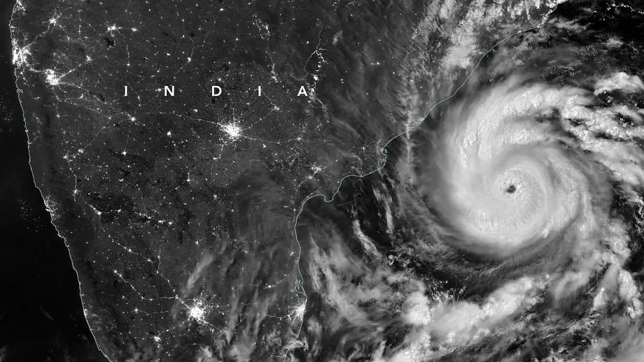
30,000 people targeted for evacuation before Murasu arrives
Andhra Pradesh authorities planned to evacuate about 30,000 people as Cyclone Murasu approached India's eastern coast, with the India Meteorological Department forecasting landfall near Ongole between 11:30 p.m. on November 2 and 4 a.m. on November 3, 2026. Winds were forecast to reach 100–110 kilometres per hour, with gusts of 120 kilometres per hour.
Contents
- 30,000 people targeted for evacuation before Murasu arrives
- Where and when was the storm expected to strike?
- Rain threatens communities beyond the landfall zone
- Andhra Pradesh maps people, shelters and essential services
- Eight radar locations support the east coast warning network
- Odisha's warning towers connect coastal villages
- Chennai faces a different drainage challenge
- Bangladesh warns ports and fishing crews
- Recovery capacity becomes part of preparedness
- Key Points
About 2,000 people had already been moved by November 2, according to Prakhar Jain, managing director of the Andhra Pradesh State Disaster Management Authority. Tamil Nadu and Andhra Pradesh were expected to bear the brunt of the storm, while heavy rain threatened districts farther inland and in neighbouring Odisha.
Jain described the evacuation effort and the number of people authorities intended to move:
Around 2,000 people have been evacuated, and the process is continuing. We are planning to evacuate some 30,000 people.
Murasu was expected to be weaker than Cyclone Arnab, which killed six people and destroyed dozens of houses and crops. Coastal communities nevertheless faced another demand on shelters, medical services, electricity networks and fishing livelihoods.
The timing of Arnab is unresolved. Its landfall is dated August 27–28 in descriptions of the earlier response, while November 2 evacuation updates place it in the preceding week. That leaves the interval between the two storms uncertain. The immediate task remains concrete: move exposed households before Murasu reaches shore and prepare essential services for wind damage and flooding.
Where and when was the storm expected to strike?
The IMD's forecast placed Murasu's likely crossing between Nellore and Narsapur, close to Ongole on the Andhra Pradesh coast. At 5:30 a.m. Indian Standard Time on November 2, the storm was centred at 13.9 degrees north and 81.8 degrees east, about 260 kilometres southeast of Ongole and 200 kilometres east northeast of Chennai.
Murasu had moved west northwest at 25 kilometres per hour during the preceding six hours. The forecast called for it to turn northwest towards the coast as a severe cyclonic storm, with its strongest sustained winds reaching 100–110 kilometres per hour.
Bangladesh Meteorological Department forecaster Dr. Md. Omar Faruk also expected the storm to cross the Andhra coast around nightfall. The IMD gave the more specific window extending from late November 2 into early November 3.
The main forecast and response dates were:
- November 2: Andhra Pradesh authorities began evacuations, with about 2,000 people moved and a target of roughly 30,000.
- Late November 2 to early November 3: The IMD forecast landfall near Ongole between 11:30 p.m. and 4 a.m. Indian Standard Time.
- November 2–3: Parts of Andhra Pradesh faced the heaviest forecast rainfall.
- November 2–4: Heavy to very heavy rain was forecast in parts of Odisha, with rain also extending into interior Andhra Pradesh and Telangana.
Rain threatens communities beyond the landfall zone
Andhra Pradesh's exposure extended well beyond the strip of coastline where Murasu was expected to cross. Forecasts identified Nellore, Prakasam, Bapatla, Guntur and Krishna among the districts facing heavy to extremely heavy rain on November 2. Tirupati, Chittoor and adjoining northern Tamil Nadu were also in the expected rainfall area.
Some locations in Andhra Pradesh could receive more than 204 millimetres of rain during November 2–3, according to the rainfall outlook. That is more than 20 centimetres of water falling on a surface before drainage or runoff carries it away. Such rainfall can overwhelm drains, fill low ground and make evacuation roads difficult to use.
As the storm moved inland, the main rain zone was expected to shift towards Rayalaseema and interior Andhra Pradesh on November 3. Kurnool, Nandyal, Anantapur and YSR Kadapa were among the areas identified, with rain potentially reaching southern Telangana.
Odisha faced forecast rainfall of 7–20 centimetres in affected areas between November 2 and 4, particularly Gajapati, Ganjam, Koraput and Rayagada. Chennai, Tiruvallur and Chengalpattu in Tamil Nadu could also receive moderate to heavy spells. The geographic spread meant authorities had to prepare for coastal wind damage and flooding across several states at the same time.
Andhra Pradesh maps people, shelters and essential services
Andhra Pradesh's Cyclone Information Management System brings storm tracks and estimates of likely landfall together with information about vulnerable residents, shelters, hospitals, schools and other infrastructure. Officials can use it to identify exposed districts and mandals, which are local administrative areas, and assess the resources needed for evacuation and relief.
The dashboard also includes assets such as electricity transformers and health facilities. Putting these on the same map as the storm helps authorities identify where damage could interrupt power or medical care, and where response teams may be needed.
During the response to Arnab, authorities opened more than 2,000 shelters across 20 districts, secured over 30,000 fishing boats and deployed nearly 1,100 medical teams. More than 180,000 people were evacuated across Andhra Pradesh and Odisha before that storm's reported landfall.
The planned evacuation of 30,000 people for Murasu was about one sixth of that earlier total. The figures cover different geographic areas: the Murasu target came from Andhra Pradesh's disaster authority, while the Arnab total covered two states.
Some local administrative units had not submitted complete information about shelters and readiness measures. For officials directing the response, incomplete reporting makes it harder to see which locations have confirmed space, supplies and staff. A digital map is most useful when its local information is current.
Eight radar locations support the east coast warning network
The IMD's 2025 annual report lists eight east coast radar locations: Chennai, Kolkata, Machilipatnam, Visakhapatnam, Paradip, Gopalpur, Sriharikota and Karaikal. Doppler weather radars help forecasters track rain and the movement of weather systems by measuring signals reflected from particles such as raindrops.
India's cyclone monitoring network also uses automatic weather stations, rain gauges, satellite observations and ocean monitoring. During Arnab, Indian Space Research Organisation satellites tracked the storm, the IMD issued warnings, and national and state disaster response units were placed on standby.
Each instrument supplies a different part of the picture. Rain gauges measure what reaches the ground at particular locations. Satellites observe broad areas over land and sea. Radar helps follow changing rain bands and winds as a storm approaches the coast.
The government has acknowledged gaps in radar coverage, particularly in coastal, hilly and island regions. The IMD has proposed additional radars along both coasts and in the Andaman and Nicobar Islands. For coastal districts, better observation supports earlier decisions about evacuations, boat movements and the placement of emergency teams.
Odisha's warning towers connect coastal villages
Odisha's Early Warning Dissemination System is designed to carry alerts to 1,205 villages across 22 blocks in six coastal districts. Its network includes 122 alert towers located within 1.5 kilometres of the coastline.
Satellite communication and digital radio links connect emergency centres at state, district and block levels. Those connections give authorities additional ways to send warnings when ordinary communication networks are disrupted by a storm.
The system addresses a practical problem: a forecast issued at state level still has to reach a household beside the sea. A family needs enough warning to gather essential belongings and reach shelter before wind, floodwater or falling trees make travel dangerous.
Odisha also maintains disaster response teams, fire services and control rooms operating around the clock. Cyclone shelters and evacuation infrastructure have received support through the National Cyclone Risk Mitigation Project. With heavy rain forecast for November 2–4, readiness in Odisha involved both coastal warnings and preparations for flooding in the districts identified in the rainfall outlook.
Chennai faces a different drainage challenge
Tamil Nadu's coastal districts face cyclone winds and coastal flooding, while Chennai must also manage intense rainfall across streets, drains and densely built neighbourhoods. Weather observation supporting the region includes automatic stations, rain gauges and radar locations at Chennai, Karaikal and Sriharikota.
The Greater Chennai Corporation has expanded and maintained its stormwater drainage network, including work on hundreds of kilometres of drains, desilting and other maintenance. Before the 2026 monsoon, it prepared pumps, vehicles and equipment for locations prone to waterlogging.
Pumps and clear drains help move rainwater away from roads and buildings. Cyclone winds and storm surges require other protections. A storm surge is seawater pushed towards land by a storm's winds, which can flood low coastal areas and obstruct the flow of water out to sea.
Chennai's preparations therefore sit alongside evacuation planning and coastal warnings. Rainfall, tides and river discharge can affect the same drainage system, making their timing important for neighbourhoods where water has few routes to escape.
Bangladesh warns ports and fishing crews
Bangladesh's four seaports, Chattogram, Cox's Bazar, Mongla and Payra, were instructed to display distant warning signal number two as Murasu moved through the west central Bay of Bengal and adjoining southwestern waters.
Bangladesh Meteorological Department meteorologist Hafizur Rahman described sustained winds of 89 kilometres per hour within 64 kilometres of the storm's centre, with gusts reaching 117 kilometres per hour. Those observations described the storm at sea; the IMD forecast stronger sustained winds of 100–110 kilometres per hour at landfall.
At 6 a.m., the storm was reported 1,440 kilometres southwest of Chattogram, 1,400 kilometres southwest of Cox's Bazar, 1,275 kilometres southwest of Mongla and 1,295 kilometres southwest of Payra.
Fishing boats and trawlers in the northern Bay of Bengal were advised to move closer to shore and proceed cautiously until further instructions. The warnings show how a cyclone heading towards India can affect maritime activity far from its expected crossing point.
Recovery capacity becomes part of preparedness
The National Cyclone Risk Mitigation Project financed much of the infrastructure behind India's coastal response. Its first phase covered Andhra Pradesh and Odisha and finished in December 2018. Its second phase covered six states, including West Bengal, and finished in March 2023.
The government reported spending about Rs 2,525 crore in the first phase and Rs 1,807 crore in the second, a combined Rs 4,332 crore. The work supported warning systems, multipurpose shelters, evacuation roads and bridges, saline embankments, underground electricity cables and disaster management training.
Successive storms place additional demands on those investments. A shelter used during one evacuation needs cleaning, supplies and staff before another. Damaged roads must be cleared, hospitals replenished and power restored. Fishing families may face another interruption to earnings while still repairing boats or homes.
Ocean conditions also affect the time available to act. Research examining Cyclones Amphan, Yaas and Mocha has highlighted the role of heat stored below the sea surface. Deep warm water can keep supplying energy as a cyclone churns the ocean, helping it strengthen rapidly.
Historical studies cited in the preparedness assessment found fewer Bay of Bengal cyclones during El Nino years than during La Nina years. Storm frequency and the strength of an individual cyclone are different parts of coastal risk. Monitoring temperatures below the surface, salinity and ocean heat content can help forecasters assess how much energy a developing storm may draw from the sea.
For districts facing Murasu, the immediate measure of readiness was more practical: whether warnings reached exposed households, evacuation routes stayed usable and shelters and medical services were ready before the forecast overnight crossing.
Key Points
- The IMD forecast Murasu to cross near Ongole between late November 2 and early November 3, 2026.
- Forecast sustained winds were 100–110 kilometres per hour, with gusts reaching 120 kilometres per hour.
- Andhra Pradesh planned to evacuate about 30,000 people; roughly 2,000 had been moved by November 2.
- Heavy rain threatened Andhra Pradesh, Tamil Nadu, Odisha and parts of the interior, extending the risk beyond the landfall area.
- Bangladesh issued distant warning signal number two at four ports and advised fishing crews to remain near shore.
- India's response draws on radar, satellites, warning towers, shelters and evacuation infrastructure, with recovery between storms adding pressure on local services.
- Arnab's reported August landfall date conflicts with November descriptions placing it in the preceding week.