Construction expands where mountain floods can strike
At least 300,000 people live in potential disaster zones across northern Nepal, southeastern Tibet and part of India's Uttarakhand, according to a study that found construction expanding fastest in places threatened by floods from glacial lakes.
Contents
- Construction expands where mountain floods can strike
- How researchers mapped the danger
- A succession of losses across river valleys
- Recovery costs reach homes, farms and businesses
- Tourism businesses face damage and lost bookings
- Hydropower concentrates valuable assets in exposed valleys
- Finding safer land without breaking communities apart
- Riverbank rules face a test of enforcement
- Repeated disasters create a larger economic burden
- Key Points
The peer reviewed research, published in Scientific Reports, found that built land in areas classified as high risk grew by about 45% between 2016 and 2023. In areas exposed to glacial lake floods, development increased by almost 78%. That means construction in those lake flood zones grew roughly 1.7 times as fast as across the wider risk area studied.
Nine researchers from Britain, Nepal and India examined river corridors extending up to 50 kilometres downstream and areas around approximately 1,360 glacial lakes. Their findings bring together two pressures reshaping Himalayan valleys: increasingly unstable mountains and growing concentrations of homes, hotels, roads and power plants below them.
The research covered a limited territory. Neighbouring valleys face similar dangers, so the number of people exposed across the Himalayas could be substantially higher.
C Scott Watson, the study's lead author and a glaciologist at the University of Leeds, said choices about construction would have lasting consequences:
As river valleys become increasingly populated, development decisions being made today will shape disaster risk for decades to come.
Those decisions are already affecting recovery in Nepal, where the August 26 Bhotekoshi-Trishuli disaster destroyed settlements and buried hydropower facilities. Authorities now face the difficult task of finding land where survivors can rebuild without losing access to work, farms and their communities.
How researchers mapped the danger
The study counted buildings within 50 vertical metres of the surface of a river or glacial lake. Vertical distance means height above the water, rather than the distance someone would walk from a building to the bank.
A house standing well back from a river can still occupy low ground reached by floodwater. Conversely, a building close to a river on a steep hillside may stand much higher above it. The shape of each valley helps determine where water, mud and boulders can travel.
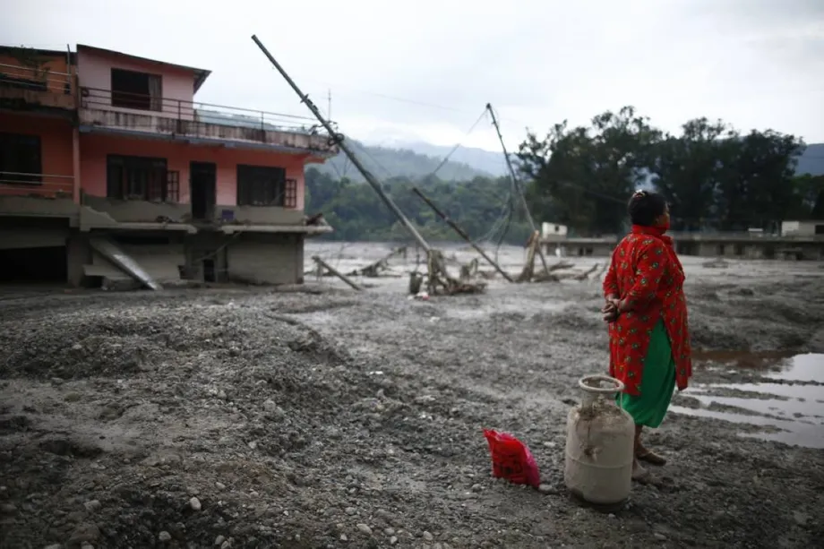
Residents in Nepal's Rasuwa district said water levels during the August disaster rose by as much as 70 metres in some places. Buildings farther from the banks were flooded and buried in debris. Their accounts show why planners also need to examine extreme flood heights and the movement of sediment when identifying safer ground.
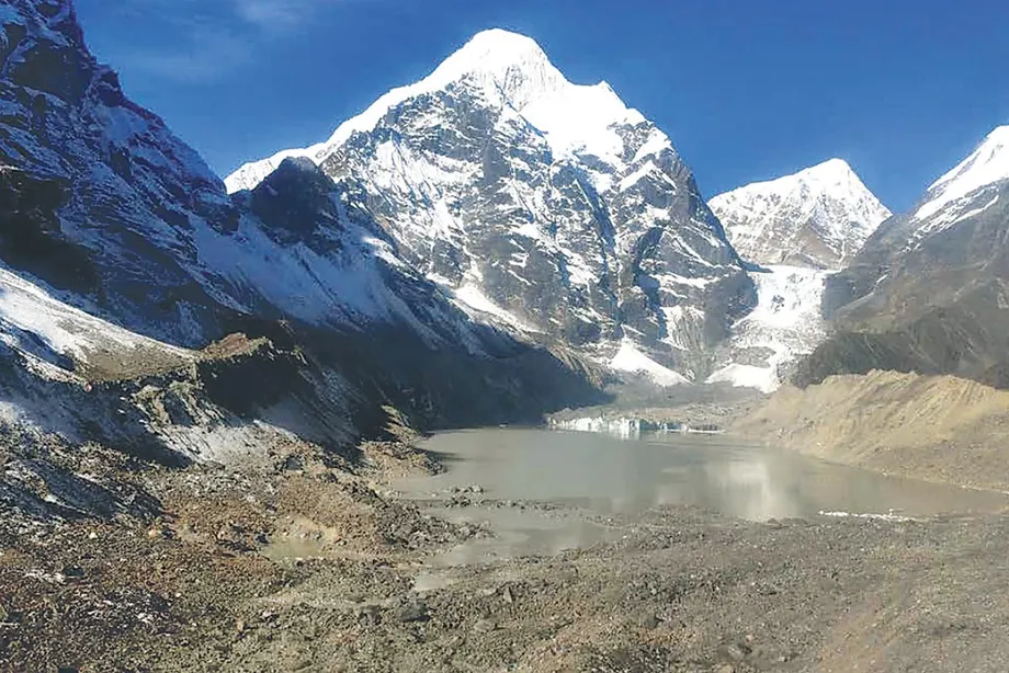
Glacial lake outburst floods happen when water suddenly escapes from a lake fed by melting ice. A collapse of rock or ice can also send material into a valley and generate a destructive surge downstream. Nepal has documented about 30 glacial lake outburst floods since 1940.
Scientists describe the Himalayan region as warming at about twice the global rate. Melting glaciers, snow and permanently frozen ground can weaken slopes, while warmer conditions bring rain to heights where precipitation previously fell as snow. Earthquakes add another source of instability.
A succession of losses across river valleys
The August 26 disaster followed the collapse of a glacier and underlying rock into a valley. Waves described as approximately 30 feet high carried water, ice and boulders downstream, sweeping away bridges and burying 12 hydropower plants along the Trishuli River.
Around 1,400 bodies were reported recovered, with more than 5,000 people unaccounted for. Brigadier General Subas Jung Thapa of the Nepali army said in early September that 121 of the dead or missing had been trapped in hydropower facilities.
The sequence of construction and disasters stretches across several years:
- 2016 to 2023: Built land in the study's high risk areas increased by about 45%, and by almost 78% in zones threatened by glacial lake floods.
- August 2025: A debris flow in Dharali, Uttarakhand, buried more than 56 hotels, restaurants and homestays.
- August 26: The Bhotekoshi-Trishuli disaster devastated settlements and hydropower facilities in Nepal.
- October 11: Flooding along the Budhi Gandaki damaged 200 houses, swept away five bridges and left five people missing.
- October 12: Uttarakhand approved new floodplain zoning rules.
Mountain travel has faced further disruption. Nepal's Department of Immigration subsequently urged an October trekking halt for October 29 to 31, 2026, because of forecast snowstorms and avalanches, while suspending new permits for restricted trekking areas.
Recovery costs reach homes, farms and businesses
Nepal's National Planning Commission estimated private losses from the Bhotekoshi-Trishuli floods at 79.17 billion Nepali rupees. Its preliminary assessment listed about 69 billion rupees in household losses and 9.69 billion rupees in business losses.
Land accounted for a large share of the damage. The assessment recorded losses of 35.44 billion rupees across 507.97 hectares belonging to 3,610 families. Residential land damage was valued at another 13.26 billion rupees, while destroyed or damaged houses were valued at 11.95 billion rupees.
The commission's digital survey, conducted by 58 field teams across 15 local levels, identified 6,817 affected families, 32,872 people and 499 businesses in Dhading, Gorkha, Nuwakot and Rasuwa. It counted 2,989 homes with complete damage. The National Disaster Risk Reduction and Management Authority's preliminary tally recorded 8,317 destroyed houses and about 1.6 million people directly affected across 15 local units, substantially broader figures than the commission's survey totals.
Crops belonging to 2,951 families were damaged, with losses exceeding 232 million rupees. Vehicles worth 1.24 billion rupees were also destroyed or damaged, affecting more than 1,100 households.
For a farming family, recovery therefore involves more than replacing a roof. Eroded land can remove the means to earn an income, while a lost vehicle or broken road can cut access to buyers, schools and medical care.
Tourism businesses face damage and lost bookings
Pokhara, a major gateway to the Annapurna trekking region, has expanded substantially over three decades. The Seti Gandaki runs through the city, where Mayor Dhana Raj Acharya said some older buildings stand only five metres from riverbanks despite rules requiring greater separation.
Acharya described the difficulty of moving established buildings and their occupants:
Where we move them, and how we do that, is the real challenge.
Farther north, settlements serving trekkers have also expanded along rivers. Homestay operator Phurpa Chhiring Lama said only five of his 20 rooms were occupied during a period when all would normally be full. That represents occupancy of 25%, compared with his usual full bookings at the peak of the trekking season.
Hotel Association Pokhara president Laxman Subedi acknowledged that tourism businesses had expanded without proper planning. He said the association was trying to raise awareness among investors and operators:
By the time disasters hit, it is too late.
Dharali shows how repeated disasters can wear down a tourism economy. Floods in 2018 and 2019 destroyed 22 houses and 24 hotels there. The August 2025 debris flow then buried more than 56 tourism businesses, alongside damage to roads, bridges and apple orchards. Residents lost both buildings and the agricultural and visitor income needed to recover.
Hydropower concentrates valuable assets in exposed valleys
The Trishuli basin contains 36 hydropower projects, including the 12 buried during the August disaster. Power development places workers, tunnels, roads and expensive machinery in valleys where water can generate electricity but also carry destructive floods.
Upper Trishuli-1, which was under construction, cost more than half a billion US dollars. Two arms of the World Bank backed it with about $300 million in loans and equity, while the Asian Development Bank provided a $60 million loan.
The World Bank said the project's design reflected flood and landslide assessments using evidence available in 2018. It said further information about the August disaster would inform consideration of risk assessment, monitoring, warnings and emergency response.
Independent experts visiting the project in 2024 identified the absence of a climate resilience assessment as a major gap. River advocate Parineeta Dandekar also questioned whether assessments had adequately examined the combined disaster risks of numerous projects along the same river.
Dipak Gyawali, a hydropower engineer with the Nepal Academy of Science and Technology, argued that the forces behind the collapse dwarfed construction blasting. He nevertheless called for closer examination of risks across concentrations of projects:
These risks have to be properly studied and assessed. Unfortunately, they have not been.
The issue extends beyond Nepal. China and India have built 68 major Himalayan dams, with another 101 planned. China's large hydropower project in Tibet is estimated to cost $170 billion and supply electricity to 300 million people, making the safety of whole river systems a matter affecting populations far downstream.
Finding safer land without breaking communities apart
Nepal's authorities are mapping settlements considered unsafe and preparing a reconstruction master plan and a Post-Disaster Needs Assessment. That assessment is intended to measure damage, lost income and the resources needed for recovery across housing, services, infrastructure and other sectors.
About 15 settlements across Rasuwa, Nuwakot and Dhading were destroyed in the August flood. At the time of the relocation assessment, 3,948 rescued people were staying in holding centres across four districts and Kathmandu.
Khalte illustrates the difficulty of finding genuinely safer ground. Uttargaya Rural Municipality chair Madhav Prasad Aryal said it had around 300 households, including people still awaiting relocation after the 2015 earthquake. The planned destination, Tallopahire, was itself partly swept away.
Former prime minister Baburam Bhattarai argued that relocation should preserve access to livelihoods and community ties. He favoured safer locations nearby rather than moving mountain residents hundreds of kilometres away:
Safer areas should be identified nearby, such as small valleys in the mountains and higher ground in the hills, where at-risk settlements can be relocated.
Nepal has experience to draw on. After the 2015 earthquake, 602 houses were built for the relocation of Laprak village to Gupsipakha. Former reconstruction authority chief Sushil Gyewali said assessments had examined about 300 settlements and identified 64 as at risk; 46 were developed as integrated settlements and 19 received protective measures.
The government is considering safer land within affected districts and possible moves to other districts. Final relocation sites, funding arrangements and whether families will receive construction grants or government built housing have not been settled.
Riverbank rules face a test of enforcement
Nepal's disaster authority says settlements within 15 metres of riverbanks along the Rasuwa-Bhotekoshi corridor will be banned, with similar restrictions planned for other corridors.
A riverbank setback controls the horizontal distance between construction and a river. Flood planning also needs to account for height above the water, unstable slopes and the possible reach of debris. The residents' accounts of water rising 70 metres illustrate the scale authorities must consider.
Surya Raj Acharya, an urban planning specialist and registrar at the University of Nepal, said accessible, relatively flat land beside rivers has attracted roads, hotels, market towns and hydropower projects. He argued that the fragile mountain environment requires stricter planning, while existing rules have been weak and poorly enforced.
Uttarakhand's October 12 cabinet decision approved rules intended to regulate floodplain development, protect people and infrastructure, and preserve the natural passage of floodwater. Activist Anoop Nautiyal said restrictions already existed on paper but were being bypassed in practice.
Basanta Raj Adhikari, director of Tribhuvan University's Centre for Disaster Studies, suggested grading locations by risk for insurance purposes. Better protection for homes in safer areas could give families and developers a financial reason to avoid more dangerous sites.
Repeated disasters create a larger economic burden
Himachal Pradesh's Economic Survey 2025-26 recorded about 460 billion Indian rupees in disaster losses over four years. Its 2025 Post-Disaster Needs Assessment contained more than 62,000 validated damage entries.
In Thunag, a 2026 study estimated direct losses from the floods of June and July 2025 at 62 million to 78 million Indian rupees. The disaster destroyed 38 homes and 14 shops, damaged 61 other homes and killed 63 cattle.
An IIT Madras assessment of 109 Himalayan districts helps explain why the most dangerous location and the least resilient community may be different places. Shimla ranked highest for hazard, meaning the threat of damaging events. Dhalai ranked highest for vulnerability, meaning how susceptible people are to harm. Darjeeling ranked highest when hazard, vulnerability and exposure were combined.
India's mitigation programmes include 10 billion Indian rupees for landslide risk reduction across 15 states and 1.5 billion rupees for glacial lake flood risk reduction in Himachal Pradesh, Uttarakhand, Sikkim and Arunachal Pradesh. For 2026-27 to 2030-31, the 16th Finance Commission recommended 408.8 billion rupees for state disaster mitigation funds.
Shreya Wadhawan of the Council on Energy, Environment and Water described how a damaged road can cut a settlement off from healthcare, schools and markets. University of Colorado mountain geographer Alton Byers said the construction study should help prompt more effective warning systems and precautions.
The practical challenge is to connect those measures: warning people before a flood, keeping new buildings out of its likely route, and rebuilding in places where families can remain safe while earning a living.
Key Points
- At least 300,000 people live in potential disaster zones within the Himalayan territory studied.
- Built land grew by about 45% from 2016 to 2023, and almost 78% in areas threatened by glacial lake floods.
- Nepal's preliminary assessment put private losses from the Bhotekoshi-Trishuli disaster at 79.17 billion Nepali rupees.
- Tourism businesses, farms, homes and hydropower facilities face linked risks from floods, debris and disrupted access.
- Nepal is preparing relocation plans and riverbank restrictions; Uttarakhand approved new floodplain zoning rules on October 12.
- Safer reconstruction must account for extreme flood heights, livelihoods, community ties and enforcement of building rules.