Batanes faces waves up to 10 metres as Rosal approaches
Super Typhoon Rosal could bring waves up to 10 metres along the northern and eastern coasts of Batanes, PAGASA warned on October 21, 2026, as government agencies prepared relief supplies, schools planned for disruptions and Malacañang reviewed a separate proposal to suspend work during extreme heat.
Contents
- Batanes faces waves up to 10 metres as Rosal approaches
- Weaker winds at the centre, continuing danger near Luzon
- The critical period runs from Thursday into Friday
- Sea restrictions reach beyond the strongest wind signals
- Bicol activates operations centres and stocks relief
- Ilocos prepares supplies across 28 storage locations
- Schools can reduce demands or pause learning entirely
- Rain offers possible drought relief, with safety first
- A work halt at a heat index of 40 degrees is under review
- Key Points
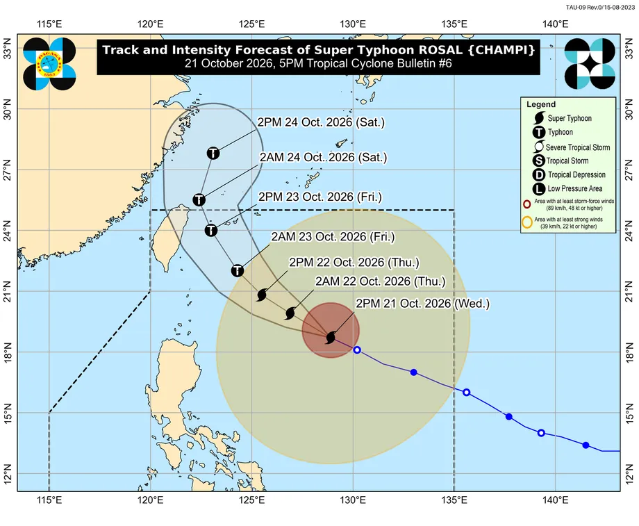
The Philippine Atmospheric, Geophysical and Astronomical Services Administration placed Rosal 725 kilometres east of Aparri, Cagayan, at 5 p.m. Wednesday. The storm, internationally named Champi, carried maximum sustained winds of 205 kilometres per hour and gusts up to 250 kilometres per hour, moving west northwest at 25 kilometres per hour.
PAGASA's Tropical Cyclone Bulletin #6 forecast the closest approach to Extreme Northern Luzon between the afternoon of October 22 and the morning of October 23. Batanes was under Tropical Cyclone Wind Signal No. 2, with Signal No. 3 the highest warning that might be raised during Rosal's passage.
Palace Press Officer and Communications Undersecretary Claire Castro said the social welfare, public works, environment and health departments were ready to respond. President Ferdinand Marcos Jr. had also directed officials to study whether work should stop when the heat index reaches 40 degrees Celsius, as communities contend with El Niño alongside the cyclone threat.
Weaker winds at the centre, continuing danger near Luzon
PAGASA's 11 a.m. bulletin had put Rosal's sustained winds at 215 kilometres per hour, with gusts reaching 265 kilometres per hour. By 5 p.m., sustained winds had fallen by 10 kilometres per hour and gusts by 15 kilometres per hour. Rosal remained a super typhoon.
The storm was expected to pass northeast of Luzon rather than make landfall in the Philippines. Its broad circulation, together with the prevailing northeasterly wind flow, was forecast to bring strong gusts across areas well beyond Batanes. Coastal and mountain communities exposed to the wind could experience stronger conditions than sheltered places.
PAGASA Administrator Nathaniel Servando said Batanes could face Signal No. 3, describing winds at that level as exceeding 100 kilometres per hour. The afternoon bulletin warned of minor to moderate wind impacts in areas under Signal No. 2 and minimal to minor impacts under Signal No. 1.
Signal No. 1 covered Cagayan, including the Babuyan Islands; Ilocos Norte; Apayao; eastern portions of Isabela; and the northeastern Catanduanes towns of Pandan, Bagamanoc, Panganiban, Viga and Gigmoto. In those areas, winds of 39 to 61 kilometres per hour were expected within the warning period. Batanes faced winds above 62 and up to 88 kilometres per hour under Signal No. 2.
PAGASA also forecast strong to gale force gusts across most of Luzon and the Visayas on October 22, extending to parts of Mindanao. Exposed houses made from light materials, trees, power poles and crops were among the assets vulnerable to damage.
The critical period runs from Thursday into Friday
Rosal entered the Philippine Area of Responsibility at about 10:40 a.m. on October 20, becoming the 18th cyclone monitored within that area in 2026. The area is the zone where PAGASA tracks tropical cyclones and issues Philippine warnings, including for storms that stay offshore.
The October 21 afternoon forecast set out a turn toward the northwest on Thursday, then north northwest on Friday and north northeast on Saturday. PAGASA expected Rosal to weaken into a typhoon by Friday and weaken further near Taiwan as conditions became less favourable.
- October 19: Catanduanes Governor Patrick Alain Azanza issued Memorandum No. 236, series of 2026, directing local officials and response agencies to prepare.
- October 20: Rosal entered the Philippine Area of Responsibility. Bicol activated a blue alert, Catanduanes imposed sea travel restrictions and the education department issued preparedness instructions.
- October 21: PAGASA maintained Signal No. 2 over Batanes and issued its 5 p.m. forecast for dangerous winds and seas.
- October 22 to 23: Rosal was expected to pass closest to Extreme Northern Luzon between Thursday afternoon and Friday morning.
- October 23 to 24: PAGASA forecast an exit from the Philippine Area of Responsibility on Friday evening or early Saturday.
The forecast placed Rosal 370 kilometres east of Basco, Batanes, at 2 p.m. on October 22, then 290 kilometres east northeast of Itbayat at 2 a.m. on October 23. The next bulletin was scheduled for 11 p.m. on October 21.
Sea restrictions reach beyond the strongest wind signals
Batanes faced the highest forecast waves, but dangerous seas extended much farther south. PAGASA projected waves up to nine metres around the remaining Batanes coasts and eastern Babuyan Islands, eight metres along northern Babuyan and northeastern mainland Cagayan, and seven metres around other parts of Cagayan and Babuyan and northeastern Isabela.
The bulletin placed parts of Ilocos Norte and Isabela under forecasts reaching six metres. Waves up to five metres were expected along northern and eastern Catanduanes and northern Aurora. Parts of Polillo, Camarines Norte, Camarines Sur, Northern Samar, Albay and Sorsogon faced waves up to 4.5 metres.
A gale warning issued that afternoon gave a range reaching 9.6 metres around Batanes and Babuyan, while the cyclone bulletin's outlook for the following 24 hours projected up to 10 metres along northern and eastern Batanes. PAGASA directed mariners in very rough seas to remain in port or seek safe harbour until winds and waves subsided.
The Coast Guard station in Catanduanes had already announced sea travel restrictions on October 20 after the five northeastern towns came under Signal No. 1. Its advisory suspended vessel movements originating from, passing through or bound for those municipalities, regardless of vessel type or tonnage, except when seeking shelter.
Smaller boats faced warnings across a wider stretch of coastline. PAGASA advised small craft, including motorbancas, against venturing into rough seas reaching three to four metres off areas including Eastern Samar, northern Quezon, La Union, Dinagat Islands, Siargao and parts of Davao Oriental. For island residents, the restrictions directly affect fishing and journeys by boat.
Bicol activates operations centres and stocks relief
Bicol's Regional Disaster Risk Reduction and Management Council placed the region under blue alert on October 20. Office of Civil Defense regional director and council chairperson Bernardo Fortes Jr. issued Memorandum 60, series of 2026, requiring emergency operations centres to run around the clock and agencies to prepare response teams and equipment.
The directive activated response groups for health, food and other relief supplies, evacuation centre management, protection of displaced people, emergency telecommunications, policing, education and early recovery. Local councils were told to assess risks, activate incident management teams and prepare evacuation centres.
DSWD Bicol director Norman Laurio was overseeing preparedness, resource monitoring and coordination. The regional office had positioned 410,158 family food packs, 22,931 items other than food and 14,137 boxes of food ready to eat in regional and local government warehouses.
Fortes also directed officials to prepare residents in areas exposed to floods, landslides and lahar for possible evacuation. Lahar is a flow of water mixed with volcanic ash and debris. Coastal communities vulnerable to storm surges were told to remain alert to local instructions.
Emergency preparations included testing communications with provincial and village response teams, updating emergency hotline information and quickly sharing weather warnings. Those steps connect regional stockpiles and personnel with communities that may need assistance.
Ilocos prepares supplies across 28 storage locations
The DSWD office in the Ilocos Region prepared 128,843 food and other relief items as Pagudpud, Ilocos Norte, came under Signal No. 1 on October 20. Supplies were distributed across one regional warehouse, two satellite warehouses and 25 active local storage locations, a network of 28 sites.
The preparations were part of the Buong Bansa Handa Program. Keeping supplies at several locations gives the department more places from which to organise deliveries if communities need help. The office said it remained on standby despite the hot conditions associated with El Niño.
Food readiness was already a concern before Rosal arrived. On October 14, officials and industry leaders described a smaller government rice reserve, with National Food Authority Administrator Larry Lacson reporting seven days of stocks in government warehouses against a legal requirement of 15 days. Much of the country's broader rice supply was held by households and private businesses.
The relief preparations and rice reserve figures concern different parts of emergency food provision. DSWD's family food packs are supplies prepared for distribution to affected households, while the public rice reserve is a stock the government can draw on during shortages and disasters. Both become important when bad weather disrupts transport and access to markets.
Schools can reduce demands or pause learning entirely
The Department of Education issued a preparedness advisory at 5 p.m. on October 20, directing schools and Schools Division Offices in potentially affected areas to activate disaster arrangements and plan for interruptions. Schools were told to secure classrooms, equipment and learning materials, keep communication channels working and coordinate with local authorities.
DepEd Order No. 014, series of 2026, provides three approaches to continuing education during disruption. Schools must consider local conditions, access to electricity and the internet, and what learners can manage at home before choosing an arrangement.
- Hinay allows essential learning with less academic pressure, using printed or digital modules and suitable resources.
- Hinga prioritises emotional and psychological well-being through light activities, short learning packets and family guidance without strict curriculum pacing.
- Hinto suspends all academic requirements so safety, communication and checks on well-being can take priority.
DepEd said class suspensions do not automatically require online lessons. Schools were also directed to position Edukahon and other learning resources under DepEd Memorandum No. 86, series of 2025, alongside emergency supplies. Families should receive arrangements suited to their school's circumstances rather than a uniform switch to internet classes.
Rain offers possible drought relief, with safety first
Castro expressed hope that Rosal's rainfall would ease water shortages in communities affected by El Niño. She encouraged residents facing drought to collect and store rainwater when conditions were safe.
The Palace press officer also identified the agencies preparing for the cyclone response:
"The DSWD, the DPWH, the DENR, and all the agencies concerned, including the DOH, are prepared for these kinds of conditions and situations," Castro said.
Residents were advised to follow evacuation orders and avoid collecting water outdoors during strong winds, lightning or flooding. PAGASA's morning outlook forecast 50 to 100 millimetres of rain in Batanes from Wednesday through Friday noon. The afternoon cyclone bulletin directed readers to Weather Advisory No. 5 for the updated heavy rainfall outlook.
Metro Manila could also experience rain, according to PAGASA Weather Division Assistant Weather Services Chief Samuel Duran, although a heavy rainfall warning for the capital was not expected when he spoke. Local rainfall warnings and evacuation instructions remain the practical guide for individual communities.
PAGASA Assistant Weather Services Chief Ana Liza Solis said historical records show more cyclones reaching super typhoon strength in October during El Niño conditions. The bureau expected up to three more cyclones before the end of 2026, while El Niño was forecast to peak before the end of the year and persist into early 2027.
A work halt at a heat index of 40 degrees is under review
Marcos directed a study of the proposed work suspension to assess whether it would protect public safety and comfort during extreme heat, Castro said. The Palace had announced neither a final decision nor specific implementation rules, and the accounts alternately described the proposed trigger as temperature and heat index.
The heat index combines air temperature and humidity to describe how hot conditions feel to the body. Humid air slows the evaporation of sweat, making it harder for a person to cool down. A heat index of 40 degrees Celsius can therefore occur when the measured air temperature is lower than 40 degrees.
Workers are awaiting a defined trigger and instructions on how any suspension would operate. For now, the proposal remains under study while disaster agencies carry out preparations for Rosal's immediate threats: damaging winds, hazardous seas and rainfall near its path.
Key Points
- Rosal carried sustained winds of 205 kilometres per hour at 5 p.m. on October 21, down from 215 kilometres per hour that morning.
- Batanes was under Signal No. 2, with Signal No. 3 possible and waves forecast to reach 10 metres on its northern and eastern coasts.
- The closest approach to Extreme Northern Luzon was forecast between October 22 afternoon and October 23 morning.
- Bicol activated emergency operations and positioned more than 410,000 family food packs; Ilocos prepared 128,843 food and other relief items.
- Schools may reduce academic demands or suspend requirements entirely according to local conditions.
- The Palace is studying a work suspension proposal during extreme heat. No final rules have been announced.