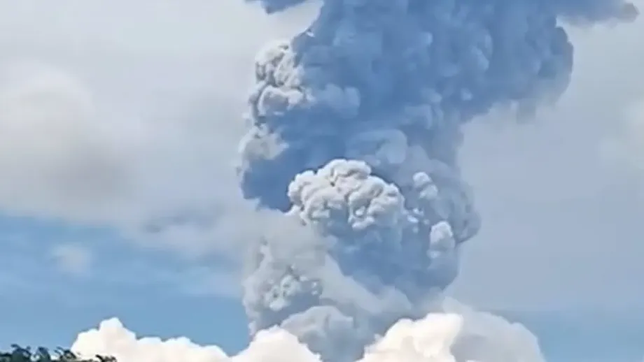
A large eruption followed by smaller ash emissions
Mount Kanlaon sent an ash plume five to six kilometers above its summit crater during a moderately explosive eruption on Saturday, October 10, prompting ashfall warnings across Negros Occidental and Negros Oriental. Further ash emissions were recorded on October 11, while the volcano remained at Alert Level 2 and authorities coordinated with local governments to assess conditions.
Contents
- A large eruption followed by smaller ash emissions
- What the official camera recording shows
- The eruption timeline has unresolved differences
- Communities experienced different effects
- Activity continued overnight and into the afternoon
- Gas and earthquake figures need careful reading
- Alert Level 2 remains, with access restrictions
- Local authorities prepare while checking needs
- What residents are being told to do
- Key Points
The large Saturday plume should not be confused with a smaller event documented in an official government video dated October 11, 2026. That recording shows an afternoon ash emission reaching 600 meters above the crater, one tenth of the six kilometer upper estimate for the Saturday eruption. The observations concern different events, rather than competing measurements of the same plume.
Communities reported different effects: booming sounds and ground shaking in Bago City, a sulfur odor in San Carlos City, and ashfall in parts of La Carlota City and Don Salvador Benedicto. The Office of Civil Defense in the Negros Island Region said those initial reports were being checked with the local governments concerned.
Important details remain inconsistent across reports, including the eruption's exact start and end times, sulfur dioxide measurements and one account of the exclusion zone. Most accounts describe a four kilometer Permanent Danger Zone. One gives six kilometers. Those discrepancies should not obscure the central safety message: volcanic unrest continued after Saturday's eruption, and restrictions remained in place.
What the official camera recording shows
The official camera recording, published through the Philippine civil defense account and attributed to the Philippine Institute of Volcanology and Seismology, documents an ash emission at 3:47 p.m. on October 11, 2026. PHIVOLCS is the government agency responsible for monitoring volcanic activity.
The agency's description identifies the Canlaon City Observation Station camera, designated KVO-CC, as the instrument that visually recorded the event. It describes a grayish plume rising 600 meters above the summit crater before drifting northwest, and states that Alert Level 2 remained in effect.
The recording establishes a specific afternoon observation. It does not establish the height or duration of Saturday's larger eruption, nor does it resolve conflicting accounts of that eruption's timing. Separating those observations matters because a video of a 600 meter plume cannot, by itself, confirm or disprove a six kilometer plume from the preceding day.
Both measurements describe height above the summit crater, rather than altitude above sea level. Keeping that reference point consistent allows a meaningful comparison between the larger eruption and the later emissions.
The eruption timeline has unresolved differences
The most consistent description of Saturday's main event is a moderately explosive eruption producing a plume five to six kilometers high, drifting north northeast. Several accounts put the explosive phase at about two minutes, with one giving the interval as 12:46 p.m. to 12:48 p.m. on October 10.
Other reports give different times. Two describe activity beginning around, or shortly before, 12:30 p.m. and ending at 12:48 p.m. Another gives 12:48 p.m. to 1:30 p.m., while a separate account places the eruption at 12:52 p.m. These timings cannot all describe the same two minute interval. It is not established whether some refer to a broader period of activity, a reporting time or an error.
The sequence of reported events is:
- October 10: A moderately explosive eruption produced a plume five to six kilometers above the crater. Reports differ on its exact timing.
- October 11, about 1:28 a.m.: An ash emission produced a 400 meter plume drifting northwest.
- October 11, about 5:15 a.m.: A grayish ash plume reached about 600 meters and drifted west.
- October 11, 2026, at 3:47 p.m.: The official Canlaon City camera recording documented a 600 meter plume drifting northwest.
The afternoon recording supplies an explicit year. The other accounts identify October 10 as Saturday and October 11 as Sunday, but do not all state a year. No subsequent hearing, briefing or deadline for an alert decision is specified.
Communities experienced different effects
Initial local observations show why conditions need to be assessed community by community. In Bago City, residents reported a visible volcanic cloud, booming sounds and ground shaking. No ashfall or sulfur odor was initially reported there.
In San Carlos City, a sulfur odor was reported in the upper portions of Barangay Codcod, without recorded ashfall. La Carlota City reported rumbling sounds, while Sitio Guintubdan in Barangay Ara-al reported both ashfall and a sulfur odor.
Ashfall was also reported in Barangays Igmayaan and Kumaliskis in Don Salvador Benedicto. These observations identify particular affected locations; they do not establish that every part of the four cities and municipalities experienced the same conditions.
The Office of Civil Defense, the agency coordinating the regional assessment, cautioned that the local observations were preliminary:
“These preliminary reports are being validated in coordination with the concerned local government units (LGUs),” the OCD said.
Validation matters because hearing an eruption, seeing its cloud, smelling volcanic gases and receiving ashfall are different observations. A community can experience one without reporting the others. The changing plume directions also mean that the areas beneath later emissions may differ from those beneath Saturday's main cloud.
Activity continued overnight and into the afternoon
PHIVOLCS recorded an ash emission at about 1:28 a.m. on October 11, with a plume rising 400 meters above the summit and moving northwest. A second emission at about 5:15 a.m. produced a grayish plume reaching 600 meters and moving generally west.
The morning event was observed by cameras at the Mansalanao Observation Station, Upper Pantao Observation Station and Canlaon City Observation Station. The separate afternoon government recording shows another 600 meter plume, this time drifting northwest.
The reported Sunday plumes were much lower than Saturday's five to six kilometer plume. Expressed in meters, Saturday's range was 5,000 to 6,000, compared with 400 to 600 for the later observations. A 600 meter plume is 10% to 12% of that earlier height range. This is a comparison of plume heights, not a measurement of the amount of ash released or the danger at ground level.
The October 11 monitoring accounts also describe an ash emission lasting 161 minutes. Another expresses the duration as two hours and 41 minutes, which is the same length of time. The reports do not establish exactly how that prolonged event corresponds to each separately timed camera observation.
Gas and earthquake figures need careful reading
Reports of the October 11 PHIVOLCS monitoring bulletin agree on 10 volcanic earthquakes during the preceding 24 hours. An earlier account gives 16 earthquakes for the day before Saturday's eruption. Those counts cover different monitoring periods and should not be treated as simultaneous measurements.
Sulfur dioxide figures are less consistent. One account gives 2,138 tons for the day before the eruption. Another gives 2,356 tons on Friday and 5,132 tons on Saturday. A third describes emissions averaging 802 tonnes per day, with a maximum of 4,656 tonnes per day on October 10.
The reports do not explain the averaging period behind the 802 figure or reconcile the differing Friday and Saturday measurements. The increase from 2,356 to 5,132 in one account is about 2.18 times, but that comparison applies only to those two reported figures. It cannot settle which measurements belong in a single confirmed daily series.
Sulfur dioxide is a volcanic gas, and its measured output gives scientists one indicator of activity below and within the volcano. Earthquake counts provide another. Neither indicator alone determines an alert level or predicts the timing of an eruption.
The October 11 monitoring account also says the volcanic edifice remained inflated, meaning the volcano's body was still swollen relative to its reference measurements. PHIVOLCS Director Teresito Bacolcol explained that gases and volcanic materials continued escaping through the vent after Saturday's eruption opened a pathway for their release. He said the agency was continuing to assess Kanlaon's condition.
Alert Level 2 remains, with access restrictions
Both the official afternoon recording and the reports of the Saturday and Sunday activity retain Alert Level 2. The level indicates increased or moderate volcanic unrest. Its continuation does not mean that ash emissions have stopped or that approaching the crater is safe.
Most accounts identify a four kilometer radius Permanent Danger Zone where entry is prohibited. They also describe restrictions on aircraft flying close to Kanlaon because sudden eruptions and volcanic material can threaten aviation.
One report instead refers to a six kilometer Permanent Danger Zone. No official document establishing a change to that radius is identified, and the official camera post does not specify a radius. Readers should therefore distinguish the widely reported four kilometer restriction from the isolated six kilometer account and follow current PHIVOLCS and local government instructions.
The hazards cited include sudden phreatic eruptions and activity associated with magma. A phreatic eruption happens when intense heat turns water into expanding steam, potentially blasting ash and rock from the vent. Such an event can be dangerous even without a newly announced increase in the alert level.
Local authorities prepare while checking needs
The Office of Civil Defense in the Negros Island Region said it was coordinating with local governments and relevant agencies to verify reports, assess conditions and identify necessary response measures. That work includes checking which communities experienced ashfall or gas odor and what assistance they require.
La Carlota convened its disaster risk reduction council and local social welfare and development office in preparation for a possible emergency. The National Disaster Risk Reduction and Management Council urged residents of both Negros Occidental and Negros Oriental to take precautions against ashfall.
The Department of Social Welfare and Development was also on standby. Assistant Secretary Irene Dumlao, its spokesperson and an official of the Disaster Response Management Group, said the department was monitoring the situation and prepared to provide additional support to local governments.
Secretary Rex Gatchalian directed the department's Negros Island Region field office and neighboring regional offices to coordinate with local authorities and determine their needs. Dumlao said food packs, essential relief items and specialized equipment could be mobilized as required.
As of 6 a.m. on October 10, the department reported more than 4.3 million family food packs, 332,716 nonfood items and 216,343 prepared food boxes positioned across its distribution network. Those are department stock figures across multiple facilities, not quantities confirmed as delivered to Kanlaon communities. No local allocation or delivery total is specified.
What residents are being told to do
Authorities advised residents experiencing ashfall to wear masks that fit securely and protective eyewear, remain indoors where possible, and keep doors and windows closed. These precautions limit contact with ash particles that can irritate the eyes and breathing passages.
Residents were also urged to observe restricted areas, follow PHIVOLCS advisories and comply with instructions from local authorities, including evacuation directions when issued. The social welfare department's readiness statement is not, by itself, an announcement of a general evacuation.
No confirmed casualty count, damage assessment, evacuation total or number of families needing assistance is given. The preliminary community reports establish that ashfall, odor and eruption sounds were observed, but they do not yet quantify their extent or consequences.
The immediate issues are the verification of local effects, continued monitoring of ash and gas emissions, and any further official decisions on access or evacuation. No scheduled date for an alert review or a subsequent public briefing is stated.
Key Points
- Saturday's eruption produced an ash plume five to six kilometers above Kanlaon's summit crater.
- Later emissions reached 400 to 600 meters. An official October 11, 2026 recording documents a 600 meter afternoon plume.
- Ashfall, sulfur odor, booming sounds and shaking were reported in different parts of Negros Occidental, with local reports undergoing validation.
- Alert Level 2 remained in effect. Most accounts specify a four kilometer Permanent Danger Zone and restrictions on nearby aircraft flights.
- Reports differ on the eruption's exact timing, sulfur dioxide totals and one account of the exclusion radius.
- Civil defense and social welfare authorities were preparing support, but no confirmed local relief delivery, evacuation or casualty totals were specified.