A moving mountainside before the collapse
Satellite radar detected up to 40 centimetres of movement on the northern face of Nepal's Langtang Lirung between 7 July and 24 August 2026, before a huge collapse sent rock, glacier ice and floodwater through the Nepal-China border corridor on 26 August. The finding offers a possible way to identify dangerous slopes, even as scientists work to establish why this mountainside failed.
Contents
- A moving mountainside before the collapse
- How rock and ice became a destructive flood
- What the satellites measured
- Was an earthquake responsible?
- Where warming fits into the investigation
- A warning arrived after the border was hit
- Electricity, transport and livelihoods disrupted
- Tourists and pilgrims caught in the disruption
- A border corridor struck twice in 13 months
- Key Points
A preliminary investigation by the International Centre for Integrated Mountain Development (ICIMOD) estimates that 132 million cubic metres of material broke away at about 8:37 a.m. Nepal time. The resulting torrent reached the Gyirong-Rasuwagadhi border area in approximately seven minutes.
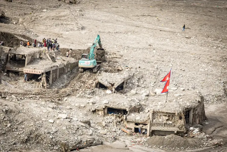
Nepal's National Disaster Risk Reduction and Management Authority recorded at least 1,451 deaths and 5,745 people missing, figures included in the investigation. Chinese authorities reported another 43 deaths and 519 people missing. Together, those figures amount to at least 1,494 deaths and 6,264 people missing across the border.
ICIMOD's 36-page investigation brings together satellite observations, seismic records, drone surveys, hydrological analysis and field assessments. Its central finding is that the disaster began with a collapse of rock and glacier ice, setting off a chain of destructive events through connected river valleys.
The catastrophe damaged homes, bridges, electricity infrastructure and a major trade route. It also exposed a practical problem for emergency services: a warning system that watches rainfall and river levels can struggle when the danger begins with a mountainside suddenly falling far above a settlement.
How rock and ice became a destructive flood
The collapse began at about 5,200 metres above sea level on Langtang Lirung's northern side. Researchers estimate that 115 million cubic metres of rock and 17 million cubic metres of glacier ice fell almost vertically for around 1,200 metres into the Lhende Khola Valley. Those volume estimates remain subject to verification.
Rock accounted for approximately 87 per cent of the estimated material, with glacier ice making up the remaining 13 per cent. That balance helps explain the immense quantity of solid debris that entered the river system.
The falling mass broke apart and mixed with water and sediment. It became a fast moving flow carrying boulders, mud and ice through the border corridor and down the Bhotekoshi and Trishuli river systems. At Gyirong port, debris travelled approximately three kilometres upstream, extending destruction against the usual direction of river flow.
An early reconstruction described debris blocking the Lhende Khola, followed by the release of impounded water. ICIMOD's investigation identifies the initiating event as the rock and ice collapse and records two temporary lakes that subsequently drained without another major disaster. The event is classified as a cascading disaster, in which one failure sets off others, rather than a conventional flood beginning with the sudden emptying of a glacier lake.
What the satellites measured
Sentinel-1 radar observations covering 7 July to 24 August showed apparent displacement of up to 40 centimetres in the area that later collapsed. Another analysis, covering 26 July to 19 August, recorded movement of up to 30 centimetres.
Radar satellites send signals toward the ground and measure what returns. By comparing observations taken at different times, scientists can detect small changes in the position of a surface, including movement that would be difficult to spot from a distant village or road.
Researchers interpret the measurements as possible evidence that the rock and ice system was gradually deforming before its sudden failure. Further work is needed to understand the movement precisely and determine how useful similar observations could be for warnings.
ICIMOD says displacement measurements cannot tell authorities exactly when a landslide or rockfall will happen. Their practical value is in identifying slopes that deserve closer observation, so officials can examine the communities, roads and power facilities that would be exposed below them.
Was an earthquake responsible?
Seismic instruments recorded a major disturbance at the time of the collapse. Early accounts described a magnitude 4.4 earthquake at 8:37 a.m.; ICIMOD's later analysis describes signals equivalent to a magnitude 5.2 earthquake and concludes that the falling mountainside probably generated the disturbance.
A large rock avalanche can shake the ground strongly enough for earthquake instruments to record it. Researchers therefore examine the timing and pattern of the signals to work out whether shaking preceded the failure or was produced by the moving mass.
ICIMOD considers an earthquake an unlikely immediate trigger. Scientists are instead examining several possible contributors, including existing fractures, damage associated with Nepal's 2015 earthquake, changes in glacier thickness, accumulated snow and ice, and repeated freezing and thawing. No single dominant cause has been identified.
Langtang Lirung had already suffered a devastating avalanche during the magnitude 7.8 earthquake in April 2015. That event struck its southern side and buried Langtang village, killing at least 300 people. The August 2026 collapse began on the northern side, within Nepal, before its effects crossed the international border.
Where warming fits into the investigation
ICIMOD reports that the rate of glacier mass loss across the Hindu Kush Himalaya has nearly doubled since 2000. The 2024-25 monitoring year recorded the greatest losses in the series examined by the organisation.
Glacier changes can affect nearby rock in several ways. Retreating ice can expose slopes that previously received support from it, while changes in ice thickness alter the weight and forces acting on fractured mountainsides. Water entering cracks can also freeze and expand, then thaw again, gradually changing the condition of the rock.
Scientists are examining permafrost, ground that normally remains frozen for at least two consecutive years. Ice within cracks can help bind fractured material together; warming can weaken that frozen support. The collapse area lies within a zone where permafrost may have existed, but researchers have not established whether thawing occurred at the failure site.
ICIMOD has identified no direct evidence connecting rapid glacier melting to this collapse. The investigation is assessing whether warming contributed alongside geological weaknesses, glacier changes and other stresses.
A warning arrived after the border was hit
Nepal's Department of Hydrology and Meteorology sent mobile alerts to approximately 679,000 people in downstream districts at around 9:15-9:16 a.m. The border corridor had already been struck by then.
The reported sequence shows how little time communities nearest the collapse had:
- 7 July-24 August 2026: Satellite radar recorded up to 40 centimetres of apparent movement on the slope.
- 26 August, about 8:37 a.m.: Rock and glacier ice collapsed into the Lhende Khola Valley.
- Approximately seven minutes later: The debris flow reached the border corridor, placing arrival at roughly 8:44 a.m.
- Around 9:15-9:16 a.m.: Mobile alerts were sent to downstream districts.
Using those clock times, the alerts followed the estimated arrival at the border by roughly half an hour. Communities farther downstream had a different window for action, depending on their distance from the collapse and how quickly information reached them.
Existing warning arrangements primarily monitor heavy rain and rising river levels. ICIMOD recommends bringing satellite observations, seismic detection and hydrological measurements into a shared system, alongside forecasts that identify which settlements and infrastructure are likely to be affected.
Electricity, transport and livelihoods disrupted
The disaster destroyed or damaged 13 hydropower projects, including facilities operating and under construction. The affected infrastructure was equivalent to approximately one tenth of Nepal's installed electricity generating capacity.
Hydropower accounted for about 44 per cent of assessed physical damage, with losses in the sector estimated at nearly 120 billion Nepalese rupees. Damage to operating plants interrupts electricity production, while destruction at construction sites delays future supply and creates additional rebuilding costs.
Transmission lines and substations also suffered damage. A solar plant with a capacity of 25 megawatts in Nuwakot was buried in sediment, extending the disruption beyond hydropower.
At least a dozen bridges were swept away, including crossings around 70 kilometres downstream. Broken bridges and damaged highways cut access along the northern transport corridor, complicating rescue, supply deliveries and journeys between communities. Early accounts described tens of thousands of people losing their homes and whole neighbourhoods being destroyed in Syaprubesi, Betrawati, Trisuli and other riverside towns.
Tourists and pilgrims caught in the disruption
The flood struck at the beginning of Nepal's trekking season and during the busy period for travel overland to Tibet. It also came two days before the 28 August full moon pilgrimage, when thousands were travelling toward Gosainkunda lake in Rasuwa.
Indian pilgrims heading to Mansarovar in China were using the Rasuwa-Gyirong crossing. Damage to the checkpoint, roads and bridges therefore affected residents, commercial traffic, tourists and religious travellers at the same time.
The Nepal Tourism Board initially listed 644 tourists as out of contact, including 178 from India and 65 from the United States. Other nationalities included Ukrainians, Malaysians, Australians, Britons and Canadians, alongside 127 Nepali travellers.
The board's immediate task was to locate those travellers. Communication difficulties included interrupted mobile service and uncertainty about who had already crossed into China, where access to some social media services is restricted.
A border corridor struck twice in 13 months
The Gyirong-Rasuwagadhi corridor was still recovering from the flood of 8 July 2025, which killed 18 people and destroyed the Friendship Bridge linking Nepal and China. Scientists traced that flood to water released from lakes or ponds on Tibet's Purepu Glacier.
The two disasters struck approximately 13 months apart but began differently. The July 2025 event started with the release of stored glacier water. The August 2026 catastrophe began with a mountainside collapsing, adding a vast quantity of rock and ice to the river valley.
Scientists are also investigating a separate recent collapse involving rock and glacier ice in Nepal's Budhi Gandaki basin. The two recent collapses occurred within seven weeks of each other, increasing concern about how to identify vulnerable slopes and protect people living below them.
ICIMOD Director General Pema Gyamtsho presented the preliminary findings at Nepal's fifth national conference on disaster risk reduction. The organisation has called for closer monitoring, faster communication and coordinated warnings between countries sharing mountain rivers. A joint team from ICIMOD and partner institutions in China planned further field investigations, although no calendar date for that work was given.
For communities along these rivers, the immediate challenge is to connect observations high in the mountains with decisions below: which slopes need attention, which settlements face exposure, and how quickly a warning can reach people before roads, bridges and escape routes are cut.
Key Points
- Satellite radar detected up to 40 centimetres of apparent movement before the 26 August 2026 collapse on Langtang Lirung.
- Authorities recorded at least 1,494 deaths and 6,264 people missing across Nepal and China.
- An estimated 132 million cubic metres of rock and glacier ice fell into the valley, with debris reaching the border corridor in about seven minutes.
- ICIMOD considers an earthquake an unlikely immediate trigger; the precise cause remains under investigation.
- Thirteen hydropower projects were damaged or destroyed, alongside bridges, roads, homes and other electricity infrastructure.
- ICIMOD recommends combining satellite, seismic and river monitoring with faster warnings and information exchange across borders.