A growing waste burden beside a river system
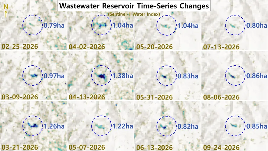
A wastewater pond below North Korea's Pyongsan uranium plant expanded from about 0.79 hectares on February 25, 2026, to 1.38 hectares in mid-April, before shrinking to 0.85 hectares on September 24. The changes, tracked with European Space Agency Sentinel-1 radar imagery, put renewed attention on a drainage route leading toward the Ryesong River.
Contents
The April peak was about 75 percent larger than the February measurement, an increase of 5,900 square meters. By late September, the pond was close to its February size. Those swings matter because the basin appears to receive liquid from a much larger pond holding waste from uranium processing in North Hwanghae province.
Commercial satellite images also show an expanding area of solid waste upstream. Between September 5, 2025, and June 27, 2026, sludge deposits in the main settling pond grew by about 0.8 hectares, or 8,000 square meters. Together, the observations describe two changes: more ground covered by processing residue and a downstream pool whose water surface repeatedly grows and contracts.
The Ryesong River, also called the Yesong River, flows south toward the Han River estuary near the border between North and South Korea. That connection gives the condition of the waste ponds importance beyond the plant itself. South Korean authorities have previously tested waters near Ganghwa Island and the estuary, finding no unusual radioactivity or heavy metal concentrations in checks conducted in 2025.
What the radar measurements show
Sentinel-1 uses radar signals to observe the Earth's surface, allowing it to collect images through clouds and at night. This is useful for following changes in a pond across months when ordinary photographs from space may be obstructed by weather.
The measurements show the downstream pond expanding during March and reaching its largest observed extent in April. Its surface then contracted through July, followed by smaller fluctuations during August and September. At its April peak, the water covered about 13,800 square meters, compared with 8,500 square meters on September 24.
A pond's surface area changes with the shape of the ground as well as the amount of water entering and leaving it. A shallow basin can spread widely after a relatively small rise in water level. Measuring its depth would be necessary to calculate the volume stored there.
Possible explanations for the changes include releases from the upstream settling pond, differences in downstream drainage, rainfall and evaporation. The central unanswered questions are how these factors contributed, whether releases were deliberately controlled, what chemicals the water contained, and whether contamination reached the river or affected people. No date for sampling at the North Korean ponds has been announced.
How waste could move downstream
Commercial imagery shows what appears to be liquid leaving the main tailings pond through a floodgate and following a drainage channel for roughly 1.1 kilometers. It then collects in a smaller basin behind an earthen barrier. Tailings are the waste materials left after useful minerals have been extracted from ore.
The downstream pond is estimated at roughly 1.03 hectares in one image assessment and 1.14 hectares in another. The Sentinel-1 series records a wider range across its February to September observations, making the date and outline used for each measurement important when comparing the figures.
The smaller basin lies about 1 to 1.5 kilometers from the main course of the Ryesong River. Images indicate a connection through an underground drain and a small stream flowing toward the river. A buried section of roughly 90 meters was described in an analysis published on July 8, 2025.
Images from June 27, 2026, show dark liquid at the settling pond's floodgate and along the drainage route. The downstream pool has a similar dark green to black appearance, with material that appears to have settled on its bottom. The visible channel, the direction of the slope and the stream connection provide a route along which material could travel.
Why the main settling pond matters
Pyongsan processes uranium ore using sulfuric acid and other chemicals to produce uranium concentrate, commonly called yellowcake. The concentrate is a raw material for further processing into nuclear fuel or material for a nuclear weapons program.
The process also produces acidic wastewater and muddy residue that may contain heavy metals and radioactive substances. A settling pond holds this mixture so that solid particles can sink to the bottom. The liquid and deposited solids then require management to limit movement into surrounding soil and water.
The main tailings pond covers approximately 34.9 hectares, including an estimated 16 hectares of solid sludge. The mapped sludge therefore occupies about 46 percent of the pond's surface area. Its thickness and the depth of the remaining liquid also affect how much material the pond can hold.
Between September 2025 and June 2026, about 0.5 hectares of new sludge appeared along the western edge, 0.2 hectares in the central deposit area and 0.1 hectares in the eastern drainage zone. The western edge accounted for nearly two thirds of the measured expansion.
Growing deposits increase the waste management burden at a facility described in earlier satellite assessments as North Korea's largest known operating uranium mine and concentration plant. Rail traffic and accumulating tailings have also been cited as signs of continued activity. Calculating yellowcake output would require information about the ore, processing rates and the amount of uranium recovered.
A drainage system watched for years
The latest observations follow years of scrutiny of Pyongsan's waste infrastructure. Commercial imagery dated March 23, 2019, showed additional waste accumulating in the tailings pond. An assessment published that August described recurring spillage at both ends of the pipeline carrying processing waste across a river tributary to the pond.
Images reviewed at the time suggested that leakage had possibly worsened during the preceding two years. They also showed a concrete reservoir retention dam downstream of the pipeline, which could potentially trap some heavy metals carried by spilled material.
A small building with a blue roof appeared near the tailings pond between October 2016 and May 2017. A whitish layer became prominent on the pond after its construction. One proposed explanation was the use of lime to neutralize acid, a process that makes acidic liquid less corrosive. The building's purpose remained uncertain.
Later imagery drew attention to new drainage construction southeast of the settling basin. A May 29, 2024, image from Maxar's WorldView-3 satellite, with a resolution of 30 centimeters, showed a ditch about 280 meters long, including a section running underground.
That assessment described an underground tunnel of about 120 meters and a connected stream about 1,920 meters long, giving a route of approximately 2.2 kilometers to the Ryesong River. Those measurements concern the construction mapped in 2024; the roughly 90-meter buried connection described in 2025 concerns the downstream pool.
The stream identified in 2024 was described as intermittent, meaning it flows after heavy rain rather than continuously. Wetness visible in the ditch on May 29 was interpreted as a possible trial discharge.
How the observations developed
Satellite images and water tests provide a record stretching from pipeline leakage concerns to construction work and the latest changes in pond size. The key dates are:
- March 23, 2019: Commercial imagery showed continued accumulation of waste at the Pyongsan plant.
- October 21, 2019: South Korea's Unification Ministry announced that samples from the Han River and Yellow Sea showed nothing unusual.
- March 2022: Satellite analysis placed the apparent start of new drainage construction near the settling basin.
- May 29, 2024: Maxar imagery showed the drainage ditch and underground section, with wetness interpreted as a possible trial release.
- July 4, 2025: South Korean agencies sampled 10 locations near Ganghwa Island and Gimpo, the Han and Imjin river estuaries, and the Incheon coast.
- September 5, 2025, to June 27, 2026: The mapped sludge area in the main pond increased by about 0.8 hectares.
- February 25 to September 24, 2026: Radar observations tracked the downstream pond's expansion, contraction and smaller later fluctuations.
The record brings together different parts of the waste system: the pipeline feeding the main pond, the construction of drainage infrastructure, deposits inside the settling basin and water collecting farther downstream.
What South Korea's water tests found
South Korean authorities sampled 10 locations near Ganghwa Island and Gimpo, the Han and Imjin river estuaries, and the Incheon coast on July 4, 2025. The Nuclear Safety and Security Commission, Ministry of Oceans and Fisheries, and Ministry of Environment conducted the work jointly.
The results and monitoring plan were published in a July 18, 2025, joint press release carried by the Ministry of Unification, titled "Concerns over wastewater from North Korea's Pyongsan uranium plant: Radioactivity and heavy metal analysis confirms no abnormalities." The document gives measurement ranges for the three groups of sampling locations.
The tests covered uranium and cesium, along with cadmium, arsenic, mercury, lead and hexavalent chromium. South Korea's Unification Ministry described the results at a press briefing:
There were no abnormalities found
At six locations near Ganghwa Island and Gimpo, uranium concentrations ranged from 0.135 to 1.993 parts per billion, compared with 0.59 to 1.97 parts per billion in 2019. At two locations in the Han and Imjin river estuaries, concentrations ranged from 0.087 to 0.122 parts per billion. At two locations along the Incheon coast, they ranged from 2.541 to 3.211 parts per billion.
Parts per billion expresses a very small concentration. For uranium in water, one part per billion is approximately one microgram per liter. The highest concentration in those tests, 3.211 parts per billion, was about 11 percent of the cited drinking water limit of 30 parts per billion.
Cesium at all 10 sites was below the minimum detectable activity, the smallest amount of radioactivity the equipment could reliably distinguish from background levels, or below levels measured in the West Sea during the preceding five years. Reported concentrations were 0.714 to 0.791 millibecquerels per kilogram at the six Ganghwa-Gimpo locations, below 0.895 at the two Han-Imjin estuary locations, and 0.727 to 1.032 at the two Incheon coastal locations. The comparison range at seven West Sea locations over the preceding five years was 0.789 to 1.928 millibecquerels per kilogram.
All five heavy metals were below applicable environmental standards or undetected. At the six Ganghwa-Gimpo locations, concentrations in micrograms per liter were 0.00 to 0.03 for cadmium, 0.93 to 1.37 for arsenic and 0.01 to 0.11 for lead; mercury and hexavalent chromium were undetected. All five were undetected at the two Han-Imjin estuary locations. At the two Incheon coastal locations, concentrations in micrograms per liter were 0.03 to 0.04 for cadmium, 1.53 to 1.79 for arsenic, 0.00 for mercury, 0.02 for lead and 0.08 to 0.16 for hexavalent chromium. The release used "undetected" for measurements below the quantification limit under the applicable water testing standards.
The South Korean government planned monthly monitoring at seven of the 10 locations and continued operation of an interagency consultative body. These samples describe conditions at those places in 2025, before the pond changes tracked between February and September 2026.
Why rainfall and containment remain central
The downstream pool appears to sit behind a simple earthen embankment rather than within a fully sealed containment structure. Heavy monsoon rain could raise its water level, produce overflow, damage the barrier or increase seepage through soil.
The basin's slope toward the river and its stream connection make water movement especially relevant. Rain could add water directly to the pool and increase flow through the surrounding drainage network. A shrinking surface could reflect water leaving through drainage, evaporation or other changes in the basin's water balance.
People living near the plant and along the Ryesong River have the closest potential connection to any local pollution. Farther south, the river's route toward the Han River estuary explains South Korea's interest in testing waters near the border. Acidity and heavy metals are concerns alongside radioactivity because uranium processing involves both chemical treatment and naturally radioactive ore.
The next practical steps are continued observation of the embankment and drainage channels, measurements of water levels, and chemical and radiological sampling along the route. South Korea's planned monthly checks address conditions at its monitoring locations, while satellite observations can follow visible changes around the North Korean facility.
Key Points
- The downstream pond grew from 0.79 hectares in February 2026 to 1.38 hectares in April, then measured 0.85 hectares in September.
- Sludge in the main settling pond expanded by about 0.8 hectares between September 2025 and June 2026.
- Satellite imagery shows a drainage route from the main pond through a smaller basin toward the Ryesong River.
- The main tailings pond covers about 34.9 hectares, including an estimated 16 hectares of solid sludge.
- South Korean tests of samples collected at 10 locations on July 4, 2025, found no unusual radioactivity or heavy metal concentrations; authorities planned monthly monitoring at seven locations.
- The composition of the downstream pond's water and the extent of any river contamination remain unknown.