A violent day on Java’s highest volcano
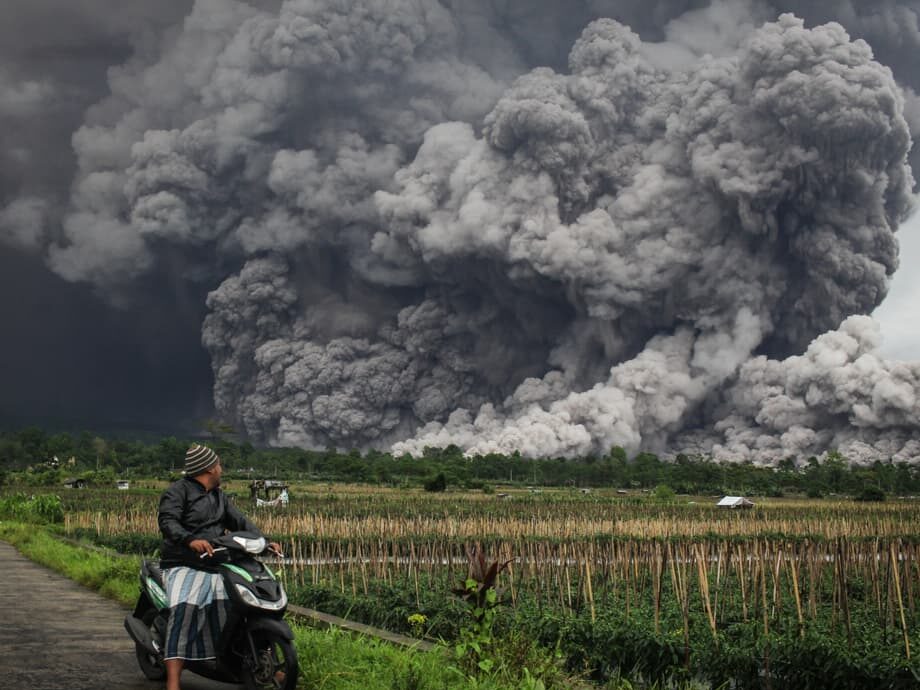
Indonesia raised the alert for Mount Semeru to the highest level after a surge of volcanic activity sent searing clouds of ash and gas racing down the mountain on Wednesday. The stratovolcano in East Java released pyroclastic flows that traveled up to 7 kilometers from the summit, while an ash column rose about 2 kilometers into the sky. Authorities widened the exclusion zone to 8 kilometers from the crater and warned residents to stay away from river valleys connected to the peak, especially the Besuk Kobokan channel that funnels hot clouds and debris. No casualties were reported as of late Wednesday, but evacuations were underway and the region remained on edge.
- A violent day on Java’s highest volcano
- Who is at risk and where evacuations are underway
- Stranded climbers at Ranu Kumbolo, safe but waiting
- How dangerous are pyroclastic flows and lahars
- What Level IV means and why the alert jumped
- Aviation and transport warnings
- Semeru’s history and life on the slopes
- What authorities are telling residents and travelers right now
- Key Points
Video captured a dense gray cloud sweeping through forested valleys and toward a bridge, a sign of powerful pyroclastic density currents. Villages experienced ash fall that coated homes and roads, forcing residents to use masks and plastic sheets to protect faces and water supplies. The National Disaster Mitigation Agency (BNPB) reported ongoing evacuations in at-risk areas, and local officials urged people in the danger zone to move to shelters and heed official instructions.
Volcanologists noted multiple eruptions through the day, from morning bursts that sent smaller ash plumes hundreds of meters above the summit to a larger afternoon event that drove the alert level to Level IV, Indonesia’s top status. Observers said the ash column drifted to the north and northwest at times as weather conditions shifted over the high slopes.
Who is at risk and where evacuations are underway
Officials confirmed that at least 300 residents left high-risk areas for shelters in Lumajang district. Evacuees came from Supiturang, Oro Oro Ombo and Penanggal villages, with temporary accommodation arranged at Oro Oro Ombo Village Hall, Penanggal Village Hall and Supiturang 2 Elementary School. Local teams continued door to door checks to verify numbers and identify anyone needing assistance. Masks, food, and clean water were distributed as ash fall accumulated on roofs and in drainage.
Lumajang Regent Indah Amperawati called on families in the southeast sector of the volcano to evacuate in an orderly manner. Her appeal targeted communities in Sumberwuluh, Jugosari, Candipuro and Pronojiwo, areas that have seen past impacts from Semeru’s hot clouds and lahars. Authorities stressed that evacuation is a precaution and urged residents to bring only essential items such as identification, medicines, and drinking water while following instructions from village officials and volunteers.
Stranded climbers at Ranu Kumbolo, safe but waiting
Authorities said about 178 people, including 137 registered climbers along with porters, guides and tourism officers, were unable to descend due to bad weather and the risk of hot ash clouds. The group sheltered at the Ranu Kumbolo monitoring post on the northern slope about 4.5 kilometers from the crater, outside the current path of pyroclastic flows that were observed moving to the south and southeast. Rescue plans were coordinated with national park rangers as rain and low visibility lingered into the night.
Endrip Wahyutama, spokesperson for Bromo Tengger Semeru National Park (TNBTS), said the group remained out of danger at the post.
They are currently safe at Ranu Kumbolo monitoring post.
Teams prepared to sustain the group overnight with supplies while continuing to assess wind, ash and rainfall. Officials cautioned that no one should attempt to move closer to the summit for sightseeing or photography while the alert stands at Level IV.
How dangerous are pyroclastic flows and lahars
Pyroclastic flows are among the most dangerous hazards at a volcano like Semeru. They are fast moving currents of superheated gas, ash and fragmented rock that surge down slopes at highway speeds. Temperatures can reach several hundred degrees Celsius. These flows can knock down trees, bury roads, and destroy buildings within minutes. They are not survivable at close range, which is why authorities have extended the exclusion zone and warned people away from valleys that can channel the flows.
The Besuk Kobokan river valley and nearby channels on the southeast side of Semeru have repeatedly served as conduits for pyroclastic clouds and debris. Indonesia’s Center for Volcanology and Geological Hazard Mitigation (PVMBG) advised people to remain outside 8 kilometers of the summit, especially along Besuk Kobokan. Residents were also told to stay at least 500 meters from riverbanks connected to the volcano because hot clouds or lahars, which are volcanic mudflows, can suddenly sweep far downstream.
Lahars form when ash and loose volcanic material mix with rain and runoff. They move like concrete and can travel far beyond the main hazard zone, threatening bridges, roads, farms and towns. With rain in the forecast, PVMBG warned that lahars could reach many kilometers downstream. Residents in low lying areas should pay close attention to the sound of rushing water in river channels and heed instructions to move to higher ground if flows begin.
Semeru’s deadly eruption in December 2021 showed how quickly conditions can change. That event killed 51 people, burned hundreds more, and buried parts of villages in mud and ash. The government later relocated nearly 3,000 houses out of the danger zone. While the current eruption has not caused reported casualties, authorities are acting early to avoid a repeat of that tragedy.
What Level IV means and why the alert jumped
Indonesia uses a four step alert system for volcanoes: Level I Normal, Level II Waspada, Level III Siaga and Level IV Awas. Level IV indicates an ongoing eruption with a significant threat to communities near the volcano. It triggers the strongest set of recommendations, including expanded exclusion zones and evacuation of high risk areas.
PVMBG raised Semeru to Level IV after a series of eruptions sent hot clouds down the volcano’s flanks and produced a large ash column. The agency expanded the danger zone to 8 kilometers from the crater and urged people to avoid Besuk Kobokan, the usual path for pyroclastic flows. Local officials in Lumajang prepared an emergency response status for one week to streamline command posts, logistics and public information.
Monitoring stations around Semeru recorded multiple events through the day, including several morning eruptions and a stronger afternoon sequence with a longer duration on seismographs. Observers reported ash drifting toward the north and northwest at times. The pattern supported the rapid alert escalation and broader safety perimeter.
Aviation and transport warnings
Volcanic ash is a serious hazard for aircraft because it can melt inside jet engines and sandblast windscreens and sensors. The Volcanic Ash Advisory Center in Darwin issued advisories for Southeast Asia’s airspace as ash rose above the summit. Pilots and air traffic controllers used satellite imagery and ground reports to adjust routes. Passengers were advised to check with airlines for schedule changes if flying through the region.
On the ground, ash fall reduced visibility and made roads slick. Local agencies distributed masks and advised residents to limit outdoor activity until ash settled. People were told to shield water storage and clear gutters before rain turned ash into heavy sludge. Power and telecommunications providers monitored equipment for abrasion and overheating that can result from ash accumulation.
Semeru’s history and life on the slopes
Mount Semeru rises 3,676 meters above sea level and is the tallest volcano on Java. It sits within the Bromo Tengger Semeru National Park, part of the Sunda Arc of active volcanoes that ring much of the Pacific. Semeru is a classic stratovolcano, built by layers of lava and ash over thousands of years. It has been active on and off for decades, with near continuous minor eruptions recorded since the late 1960s.
Despite frequent activity, communities continue to live and farm on the volcano’s fertile slopes. Volcanic soils are rich in nutrients, which support crops and livelihoods. That benefit comes with risk. Many villages sit near river valleys that can carry hot clouds or mudflows during eruptive episodes. Preparedness campaigns, evacuation drills and hazard maps aim to reduce danger for people who call these landscapes home.
The December 2021 eruption was the strongest in recent years. It killed 51 people and forced more than 10,000 residents to flee. In the aftermath, authorities relocated almost 3,000 houses away from high hazard zones and reinforced bridges and culverts along lahar paths. This week’s rapid evacuation orders and expanded exclusion zones reflect lessons learned from that disaster.
What authorities are telling residents and travelers right now
Agencies urged residents, visitors and climbers to avoid the exclusion zone and follow official guidance while Semeru remains at Level IV. The priority is to keep people out of the way of hot clouds, lahars and ash. Local and national bodies are posting regular updates and will adjust restrictions if activity changes.
- Stay beyond 8 kilometers from the summit and follow local roadblocks and signage.
- Keep away from the Besuk Kobokan channel and other rivers that drain the summit, especially in the southeast sector.
- Avoid riverbanks within 500 meters because lahars and hot clouds can surge suddenly and travel far downstream.
- Wear masks or cloth coverings to reduce ash inhalation, and protect eyes with glasses if ash is falling.
- Move vehicles under cover where possible and brush ash from roofs to prevent overloading when rain arrives.
- Do not attempt to climb or approach the crater or observation points for photos while the alert is at Level IV.
- Follow updates from PVMBG, BNPB and local disaster agencies (BPBD) and rely on verified channels.
- Tourists should postpone hikes and camping trips in the national park until authorities declare it safe.
Key Points
- Mount Semeru erupted on Wednesday, sending pyroclastic flows up to 7 kilometers from the summit and an ash column about 2 kilometers high.
- Authorities raised the alert to Level IV Awas and widened the exclusion zone to 8 kilometers from the crater.
- At least 300 residents from Supiturang, Oro Oro Ombo and Penanggal moved to shelters in Lumajang district.
- About 178 people, including climbers and guides, remain at the Ranu Kumbolo monitoring post on the northern slope and are reported safe.
- Officials warned residents to avoid the Besuk Kobokan river valley and riverbanks due to the risk of hot clouds and lahars.
- The Darwin VAAC issued ash advisories for aviation as air routes were adjusted around the plume.
- No casualties were reported as of Wednesday night, but an emergency response status is in effect for one week.
- Semeru is one of Indonesia’s most active volcanoes and last had a deadly eruption in December 2021 that killed 51 people.