A vast coastal defense with millions of lives at stake
Indonesia plans to spend about US$80 billion on a coastal defense stretching at least 500 kilometers along northern Java, where rising seas and sinking land are flooding homes, factories and roads. The project would run from Banten in the west to Gresik in East Java, with some planning documents putting its length at about 700 kilometers.
Contents
- A vast coastal defense with millions of lives at stake
- What would the giant seawall include?
- Why the sea is gaining ground
- Who will oversee the project and pay for it?
- What protection could mean for coastal families
- Fishers and pond farmers face a different calculation
- Why rivers and habitats matter to the design
- Jakarta will test whether the whole system works
- What needs to happen beyond the barrier?
- The economic corridor the government wants to preserve
- What to Know
As of November 12, 2025, the national vision calls for construction in phases over 15 to 20 years, protecting roughly 20 million people who live and work in districts exposed to flooding. Jakarta Bay is expected to be the first major phase, with a presidential estimate of US$8 billion to US$10 billion and eight to ten years for construction and commissioning.
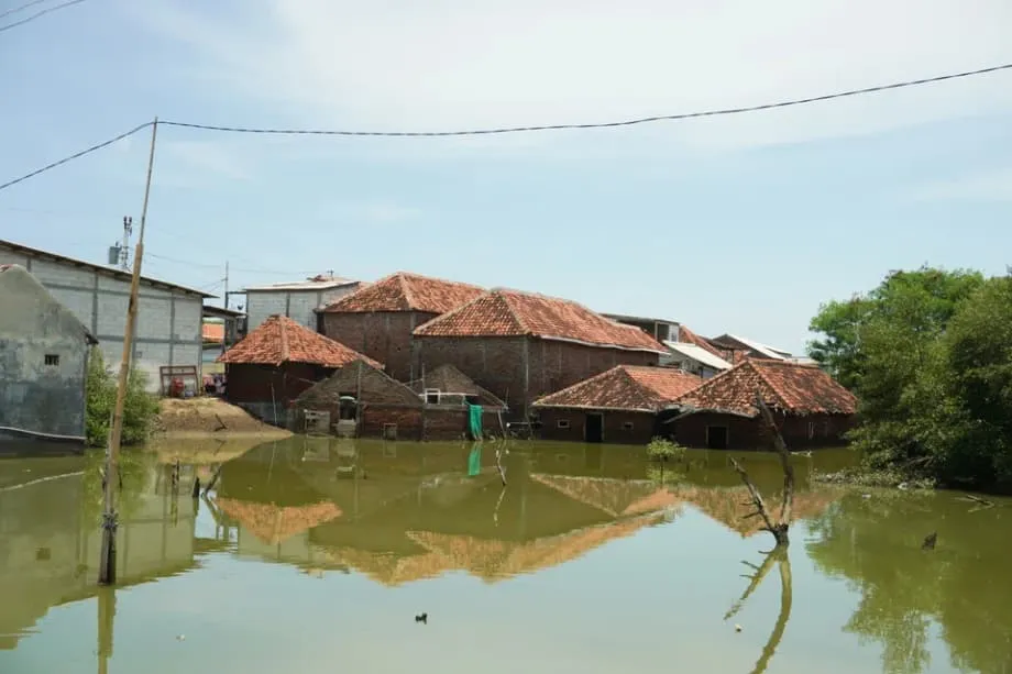
Demak Regency in Central Java shows why the government wants to act. Three villages have been lost to the sea in the past decade. One settlement was submerged last year, forcing more than 100 families to move inland. Across Java's northern shore, homes and workshops have become places where seawater regularly gathers.
Muhammad Kharis, 52, a lifelong Demak resident, said flooding that once came seasonally has become more frequent and higher with each passing year. He described the financial strain of repeatedly repairing a home exposed to the tides.
It feels like fighting the sea every day. We spend money just to stay afloat. The moment we stop, the water takes over.
The government's answer is a chain of coastal defenses intended to keep this economic corridor functioning while Indonesia tackles the causes of sinking land. Its success would depend on much more than the strength or height of a wall.
What would the giant seawall include?
The barrier would not be one uninterrupted structure. Plans combine raised dikes, upgraded coastal roads, tidal gates, pumping stations and reinforced embankments connected to rivers and drainage systems. Each stretch would have a different design, depending on the number of people living nearby, the economic assets needing protection and the ground beneath it.
Jakarta Bay, northern Semarang, Pekalongan and Brebes are among the priority areas, alongside other places where tides already overwhelm neighborhoods several times a month. Connecting coastal protection to existing river levees and urban drainage is intended to stop water from backing up behind the defenses.
Central Java already has a prominent example under construction. The coastal defense between Semarang and Demak is 6.7 kilometers long and doubles as a toll road. Work began in 2023, and the project was reported to be about halfway complete in early October 2025.
Built up areas would receive structures resembling a fortress. Less populated stretches are intended to use softer protection, including mangrove belts and zones that leave space between development and the shore. The plan therefore combines heavy engineering with measures that give the coastline room to change.
The main dates and periods described for the project and the pressures behind it are:
- 1992 to 2024: Indonesia's meteorology and climate agency measured average sea level rise around the archipelago at about 4.25 millimeters a year.
- 2016: A Ministry of Marine Affairs and Fisheries study linked parts of the Jakarta coastal plan to annual losses for local fishing households.
- 2023: Construction began on the coastal defense and toll road between Semarang and Demak.
- 2024: A settlement in Demak was submerged, and more than 100 families had to move inland.
- Early October 2025: The Semarang to Demak project was reported to be about half complete.
- Planned construction periods: Eight to ten years for Jakarta Bay and 15 to 20 years for the wider coastal program.
Why the sea is gaining ground
Java's northern coast faces two changes at once: the ocean is rising, and parts of the land are sinking. A warming climate raises sea levels because warmer water expands and melting ice on land adds water to the oceans.
Indonesia's meteorology and climate agency reports that average sea levels around the archipelago rose about 4.25 millimeters annually from 1992 to 2024, with signs of faster increases in recent years. In parts of northern Java, however, the land has been sinking much faster than the sea has risen.
Surveys have measured cumulative drops of tens of centimeters in some neighborhoods and up to two meters in the worst affected pockets. These changes magnify flood risk: a street can become lower relative to the sea even before the ocean rises further.
Groundwater extraction is a major driver. When homes and factories pump underground water faster than it can be replaced, soft clay layers compress. Streets, pipes and building foundations sink with them. Districts that once stood just above high tide can fall below the water line.
Rapid urban growth and industries needing large amounts of water have long depended on deep wells. Piped water networks do not yet reach every district with reliable pressure, leaving households and businesses reliant on pumping. Switching to surface water and controlling groundwater extraction are therefore central to slowing the loss of land height.
Sinking ground also makes drainage harder. Rivers and drains normally use gravity to carry water toward the sea. As land drops, outlets sit lower relative to the ocean, and rainwater can stall rather than flow away. Any barrier keeping tides out must be paired with pumps, detention ponds that temporarily store water, and channels that let inland water escape.
Who will oversee the project and pay for it?
The presidency has created the North Java Coast Management Authority to direct planning, contracts and operations. Didit Herdiawan Ashaf, a former senior navy officer and deputy minister of maritime affairs and fisheries, has been appointed to lead it.
Two deputies support him: Darwin Trisna Djajawinata, who has experience in state owned investment, and Suhajar Diantoro, a former senior Home Ministry official. The new authority is intended to coordinate a project crossing provincial boundaries and involving many different coastal systems.
President Prabowo Subianto has presented the seawall as essential public infrastructure and called for urgent action.
Sea waters have threatened the lives of our people. One of the most vital infrastructure projects that we need to do promptly is the giant seawall across the northern Java coast.
Indonesia is seeking investment through public and private partnerships, known as the PPP model. This means public authorities and private partners would share responsibilities for financing and delivering the work under agreed arrangements. Talks are continuing about dividing construction into phases that different investors could support.
Potential partners include China, Japan, South Korea and European countries with coastal engineering experience. The Netherlands has long advised on Jakarta's polder systems, which use barriers and controlled drainage to manage water in low areas. Japan rebuilt many seawalls after the 2011 tsunami, while South Korea has one of Asia's longest seawalls.
Supporters say a single authority could improve coordination across provinces. Critics worry that an extra administrative layer could cause delays if competing permits and overlapping plans remain unresolved. Both sides see stable financing, realistic schedules and maintenance arrangements from the beginning as necessary for a project lasting decades.
The stated timelines describe construction periods; no exact starting date for the Jakarta Bay phase or completion date for the national program was given. Financing discussions also remain underway.
What protection could mean for coastal families
Sayung, an industrial district in Demak, has streets where seawater splashes against concrete, rusted gates and shuttered shops. Lanes fill to knee depth. Tides arrive repeatedly, cross pavements and withdraw before returning again.
Families respond by repairing walls and raising floors, turning flood protection into a recurring household expense. For residents in these neighborhoods, a barrier working together with pumps could mean dry homes, clean tap water and streets that reopen for trade.
Bedono village near Demak illustrates how long people have adapted to inundation. Cooking, commuting and other daily routines have continued in water for almost a decade. Residents say even a partial reduction in flooding would bring relief, and households accustomed to years of tides reaching their ankles see protection as a lifeline.
Relocation remains another pressure. At least three Demak villages have already disappeared into the sea, and more households face a decision about moving inland. Local leaders have called for fair compensation, housing plots on higher ground and retraining for people whose employment depends on coastal access.
Residents fear that a wall could protect the economic corridor while leaving some of its communities without a secure livelihood. A social plan would need to address both where families can live and how they can continue earning money.
Fishers and pond farmers face a different calculation
Small scale fishers and coastal farmers depend on the movement of water that the seawall would change. Early construction sections have already altered currents and the way silt moves. Fishers report smaller catches of fish, crabs and mussels near construction zones.
Fish farm operators in some hamlets say embankments and access roads have changed the flow of brackish water into their ponds. Brackish water is a mixture of fresh and salt water, and its circulation matters to farms built around coastal conditions.
Fishing communities also worry about losing access to their working grounds. A barrier could require longer journeys to reach open water, increasing fuel spending and exposing crews to additional safety risks. Their needs differ from those of factories and roads that benefit mainly from keeping the sea out.
A 2016 study by the Ministry of Marine Affairs and Fisheries linked segments of the Jakarta coastal plan to measurable annual losses for local fishing households. Expanding the construction footprint without new safeguards could spread those losses to more communities.
Compensation would need to account for fishers, farmers and small businesses as well as households moving away from flooded land. Clear information and a way to share in the benefits of safer ground are part of the challenge facing the project.
Why rivers and habitats matter to the design
Conservation groups and urban planners warn that a hard barrier can be a blunt tool on a changing delta. A continuous wall would alter the movement of sand and mud, limit the tidal flushing that brings oxygen into estuaries, and make it harder for mangroves to spread inland as the sea advances.
River mouths are a particular concern. Rivers confined by embankments could hold more polluted water upstream if coastal defenses close their outlets during high tides. The design must account for water arriving from inland as well as water pushing in from the sea.
Elisa Sutanudjaja of the Rujak Center for Urban Studies has urged the government to base decisions on hydrology, the study of how water moves, and to protect river mouths, wetlands and mangrove belts. She cautioned against treating one huge structure as a cure for every flooding problem.
If a wall blocks river mouths and bays, it can slow water flow to the sea, accelerate sedimentation, and make floods worse in the very districts the project intends to help.
Dredging creates another environmental risk. Work in harbors and channels near the shore supplies fill material for construction sites, but disturbed silt can settle on reefs and seagrass beds. Those deposits can smother habitats used by young fish.
Erwin Suryana of the People's Coalition for Fisheries Justice argues that the plan addresses flooding while leaving its deeper cause, sinking land from groundwater extraction, unresolved. He said communities bear the burden of that mismatch.
The giant wall is a false solution that creates new hardships for people.
Jakarta will test whether the whole system works
Jakarta is one of the world's fastest sinking large cities, making its bay the proposed location for the first major phase. The city sits on alluvial clay, and parts of its coastline have dropped by several centimeters a year.
Officials say the new coastal defense would work alongside improved water supplies to reduce groundwater pumping, new pump houses at canals and higher levees around lakes used for storage. The aim is to buy time while addressing the processes that make the city more vulnerable.
Jakarta's budget of US$8 billion to US$10 billion represents about 10 to 12.5 percent of the estimated US$80 billion national cost. Its planned eight to ten years of construction and commissioning would therefore be a substantial early commitment within the wider program.
Existing local seawalls have failed before. Breaches flooded low districts and industrial areas, showing why protection needs to operate as a complete system. Experience in the Netherlands and other lowlands points to requirements including backup power for pumps, sediment management and operators able to respond to tides and storms as conditions change.
Jakarta would provide a practical test of whether tidal protection, better drainage and reduced groundwater extraction can work together. Success on those three fronts would support the wider plan. Failure would bring a costly warning before further sections are built.
What needs to happen beyond the barrier?
Coastal safety involves keeping seawater out, allowing inland water to move and slowing the sinking of land. On Java's northern coast, much of that work begins away from the shoreline.
Reliable piped water and treatment plants using surface water could reduce dependence on deep wells. Enforcing groundwater permits, charging for extraction and closing illegal taps could help control pumping. Industries in districts exposed to flooding could use recycled water and cooling systems that circulate water repeatedly rather than continually drawing new supplies.
Mangroves can absorb wave energy and trap sediment. Restoring them, and allowing space for forests to move inland where possible, would create a living edge in front of coastal structures. Reconnecting upstream rivers with floodplains could also reduce peak storm flows before they reach the coast.
Dredging rules could be revised to limit clouds of disturbed sediment and protect seagrass and coral areas where young fish grow. These measures would address some of the habitat damage associated with construction and changing coastal flows.
Some districts would still need managed retreat, meaning an organized move from the most exposed places to safer land. That would require risk maps, land purchases inland, and new homes, schools and clinics before families relocate. Safer harbors with new jetties and cold storage could help fishing communities retain sea access and income.
Trust also matters. Successful examples abroad depend on it. Project offices could publish contracts and weekly progress dashboards, accept residents' input on routes, and arrange independent environmental audits. Credible compensation for fishers, farmers and small businesses could help turn disputes into cooperation.
The economic corridor the government wants to preserve
Java's northern coast contains dozens of industrial estates, five special economic areas, ports, fuel depots and power plants. Many lie within a few kilometers of the sea. Repeated tidal flooding interrupts shifts, damages stored goods and corrodes machinery.
Toll roads, container yards and export factories form a connected logistics network where schedules are measured in hours rather than days. Flooded roads and facilities can disrupt that network even when the damage is confined to one part of the coast.
A defense adapted to each stretch of shoreline could reduce repeated losses and emergency spending after storm tides. It could keep warehouses dry, maintain truck access and reduce saltwater entering water treatment plants.
The same structures would change the waters used by fishers and aquaculture farms. Protecting industry while maintaining coastal livelihoods requires fair treatment, reliable information and practical ways for affected communities to benefit. Financing and engineering will shape the project, but water supply, drainage, maintenance and compensation will determine how well that protection works in daily life.
What to Know
- Indonesia plans coastal defenses from Banten to Gresik, described as at least 500 kilometers long, with some planning documents citing about 700 kilometers.
- The estimated national cost is US$80 billion, with construction in phases over 15 to 20 years to protect roughly 20 million people.
- Jakarta Bay is the proposed first major phase, costing US$8 billion to US$10 billion over eight to ten years.
- The North Java Coast Management Authority is led by Didit Herdiawan Ashaf, supported by Darwin Trisna Djajawinata and Suhajar Diantoro.
- The 6.7 kilometer Semarang to Demak defense doubles as a toll road; construction began in 2023 and was about half complete in early October 2025.
- Average sea levels around Indonesia rose about 4.25 millimeters annually from 1992 to 2024, while some northern Java locations have sunk much faster.
- Indonesia is seeking partners from China, Japan, South Korea and Europe through public and private partnerships.
- Residents seek relief from repeated floods, while fishers and pond farmers report losses near construction zones.
- Groundwater controls, better water supplies, working drainage, habitat protection and fair relocation arrangements are central to the plan's performance.