Fresh friction over a Chinese survey ship near Amami Oshima
Japan lodged a formal protest with China after the Japan Coast Guard reported a Chinese ocean research vessel suspected of conducting survey work inside Japan’s exclusive economic zone to the west of Amami Oshima in Kagoshima Prefecture. Patrol crews said the ship was seen lowering a pipe like or wire like device into the water early in the morning on multiple days this week, then continued operations despite warnings. Tokyo argues that such research requires prior consent from the coastal state and says the activity must stop.
- Fresh friction over a Chinese survey ship near Amami Oshima
- Where the sightings occurred and what is at stake in an EEZ
- How Japan and China draw the boundary in the East China Sea
- What the Chinese survey ship may have been doing at sea
- Law, practice, and the limits of enforcement at sea
- Recurring incidents and the wider strategic picture
- Why mapping matters beyond science
- Crisis management and communication channels
- What happens next
- Key Points
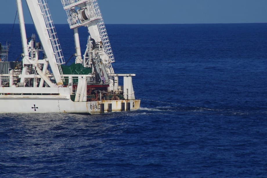
According to officials, the vessel identified as Xiang Yang Hong 22 was first observed on Sunday about 380 to 400 kilometers west of Amami Oshima. The Coast Guard said it issued radio messages demanding the survey be halted. The ship moved westward roughly three hours later on Sunday, then returned to nearby waters on Tuesday and again before 7 a.m. on Wednesday, where it was seen deploying similar equipment in adjacent areas that Japan includes within its EEZ.
Chief Cabinet Secretary Hayashi Yoshimasa told reporters that Japan had lodged a strong protest through diplomatic channels and would continue to respond with firmness and calm. He reiterated that maritime research in the zone without permission is unacceptable.
“Marine scientific research in Japan’s EEZ without our consent is not acceptable. The activities are extremely regrettable and must stop immediately,” Hayashi said.
Beijing had not issued a specific public comment on this episode at the time of reporting. Chinese authorities have long rejected Japan’s use of a median line as a maritime boundary in this part of the East China Sea and say there is no agreed border. That stance underpins repeated incidents involving survey or patrol vessels in areas where claims overlap.
Where the sightings occurred and what is at stake in an EEZ
The sightings were recorded in waters west of Amami Oshima, a major island in Japan’s southwest. The location places the ship in the East China Sea, a relatively narrow body of water bordered by China, Japan, and South Korea. Because the sea is less than 400 nautical miles wide in many areas, the outer limits of maritime zones claimed by neighboring states can overlap. That overlap is a core source of friction.
An exclusive economic zone grants a coastal state sovereign rights for exploring, exploiting, conserving, and managing natural resources in the water column and on the seabed out to 200 nautical miles from its coast, consistent with the United Nations Convention on the Law of the Sea (UNCLOS). The coastal state also has jurisdiction over marine scientific research and environmental protection in that zone. Ships from other countries enjoy freedom of navigation in an EEZ, but if they wish to conduct marine scientific research there, they are expected to seek and obtain consent from the coastal state. This rule sits at the heart of Japan’s protest.
How Japan and China draw the boundary in the East China Sea
Japan bases its claim on a median line principle, which draws a boundary halfway between the two coasts. China argues that the natural prolongation of its continental shelf extends farther to the east and that the maritime boundary should reflect this geology. Because the two sides rely on different legal approaches, they have never settled the boundary in the East China Sea.
Japanese media and officials say the Chinese ship operated near or east of the line Tokyo uses as a practical boundary for its EEZ. China does not accept that line. The result is a cycle in which research or patrol activity becomes a trigger for warnings and diplomatic protests, without a shared map that both sides recognize.
Disagreements over the status of land features also feed into the dispute because islands, rocks, or reefs can change the maritime zones that states claim. In May 2025, after a separate incident near Okinotorishima, Chinese Foreign Ministry spokeswoman Mao Ning stated Beijing’s view of that feature. She said it could not generate an EEZ or continental shelf.
“Okinotori is a reef, not an island, and therefore not entitled to an Exclusive Economic Zone or continental shelf under UNCLOS,” Mao said at the time.
Tokyo rejects that interpretation and maintains that Okinotorishima is an island. The disagreement illustrates how legal definitions become strategic issues, since the classification of features can expand or shrink where each state claims special rights at sea.
What the Chinese survey ship may have been doing at sea
Chinese research vessels in the Xiang Yang Hong fleet are operated for ocean observation and study. The device seen hanging from Xiang Yang Hong 22 was described by Japanese authorities as pipe like or wire like. Survey ships commonly use wire line winches to lower instruments such as conductivity temperature and depth sensors, acoustic transducers, sediment corers, or sub bottom profilers. They may also deploy towed sonar arrays to map the seabed or measure water properties.
These activities can serve academic science, resource exploration, and navigation safety. They can also carry a dual use character. Seabed maps and acoustic data are valuable for routing submarines, planning undersea cable corridors, and positioning seabed sensors. That dual use potential is one reason coastal states insist on consent for research in their EEZ and keep close watch on survey patterns around sensitive waters.
Law, practice, and the limits of enforcement at sea
UNCLOS draws a distinction between transit and research. Navigation through an EEZ does not require permission, but marine scientific research in an EEZ is subject to consent by the coastal state. There is debate among practitioners about whether certain hydrographic or military ocean surveys fall under research that requires consent or fall under high seas freedoms of navigation. Different countries use different interpretations. Japan requires consent for research in its EEZ and treats activity like equipment deployment and sampling as research if done for data collection. China takes a strict view when foreign research vessels operate in its claimed EEZ, yet it has also conducted surveys in zones claimed by neighbors, citing other legal principles. The inconsistency fuels friction across the region.
Even when a coastal state believes its EEZ rights are infringed, options at sea are limited. EEZ waters are not the same as territorial seas. Foreign ships are not barred from passing through. Japan can document activity, broadcast warnings, demand a halt to the work, and lodge a diplomatic protest. It can also increase patrol presence and publicize incidents to deter repeats. Forcible measures carry risk and can be unlawful if they exceed what international and domestic law allow outside territorial waters. That is why many of these incidents end with warnings, shadowing, and diplomatic exchanges rather than arrests.
Recurring incidents and the wider strategic picture
Survey sightings in and around Japan’s claimed EEZ have become a regular feature of regional maritime activity. The latest sequence near Amami Oshima follows earlier reports of Chinese research ships operating near other parts of Japan’s claimed EEZ, including waters around Okinotorishima. The same pattern appears in the East China Sea near gas fields that sit close to competing claim lines.
The East China Sea already hosts several sensitive friction points. The Senkaku Islands, administered by Japan and claimed by China where they are known as Diaoyu, remain a focus of coast guard patrols and aerial activity. Further north, Chinese and Japanese claims over the edge of the continental shelf and proximity to resources such as the Chunxiao gas field have generated periodic protests. Each new survey or drilling step is viewed through this lens and can draw immediate reaction from the other side.
Why mapping matters beyond science
Ocean research benefits climate science, fisheries management, and disaster preparedness. Yet the same datasets also help navies and energy planners. Precise seabed charts, acoustic profiles, and current measurements inform submarine routes and quiet operating areas. They influence where to lay fiber optic cables and how to design pipelines. In an era of intense maritime competition, coastal states keep a protective stance toward research in waters where they hold resource rights and security interests.
Japan’s protest underscores concerns that unapproved surveys in its EEZ could produce data with strategic value. Even if a survey is framed as scientific, the information can be applied to both civil and military uses. That is a standard reality of oceanography. It is also why nations negotiate research access and, in many cases, undertake joint projects to share benefits and build trust.
Crisis management and communication channels
Tokyo and Beijing have built some tools to avoid accidental clashes. The two governments launched a maritime and air communication mechanism to reduce the risk of miscalculation, and a direct defense hotline started operating more recently. These channels are designed to clarify intent, share navigational warnings, and keep tactical interactions from spiraling into broader confrontations.
Communication does not resolve legal differences, but it lowers risk. Regular use of hotlines, timely notice of research plans, and predictable patrol patterns can help ships give each other a wide berth. Incremental measures like these reduce the chance that a warning at sea turns into a collision or a dangerous close approach, which would complicate already difficult diplomacy.
What happens next
Japan has filed its protest and says the Coast Guard will continue to monitor the area while urging the Chinese vessel to stop operating in its claimed EEZ. Working level exchanges between the two governments are likely to continue through established diplomatic channels. Tokyo will keep pressing its view that research in its EEZ requires prior consent and will catalogue activity as evidence to support future démarches.
Beijing is expected to maintain that no boundary exists where Japan uses a median line and that its ships may operate lawfully in those waters. Without a negotiated maritime delimitation, these positions will continue to collide. Practical steps are available. The countries could expand prior notification regimes for research cruises, agree to joint scientific expeditions in overlapping claim areas, or set no go windows around sensitive periods. Such measures would not settle boundaries, but they would make friction less frequent and less intense.
Key Points
- Japan protested to China after a Chinese survey vessel, Xiang Yang Hong 22, was seen lowering equipment in waters Japan claims as its EEZ west of Amami Oshima.
- Japanese patrols observed the ship on Sunday, Tuesday, and Wednesday in roughly the same area about 380 to 400 kilometers west of the island.
- Chief Cabinet Secretary Hayashi Yoshimasa said marine scientific research in Japan’s EEZ without consent is unacceptable and demanded the work stop immediately.
- China rejects Japan’s median line approach to the East China Sea boundary and says there is no agreed maritime border in the area.
- Under UNCLOS, coastal states hold resource rights and jurisdiction over marine scientific research in their EEZ, while foreign ships retain navigation freedoms.
- Disputes over the status of features like Okinotorishima, and broader tensions around the Senkaku Islands and nearby gas fields, add to the friction.
- Both sides have communication channels to manage risks at sea, but without boundary delimitation, survey and patrol incidents are likely to recur.