A coast under pressure
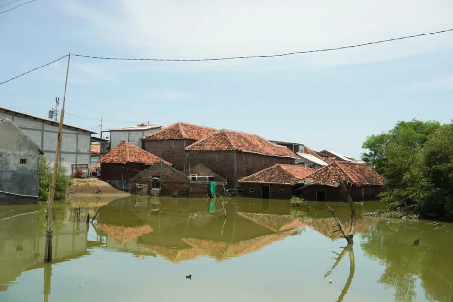
On a quiet afternoon in Sayung, an industrial district in Demak Regency, Central Java, the steady hum of factories has faded into the splash of seawater against concrete. Rusted gates, shuttered shops, and knee deep lanes tell a story of a shoreline that is losing ground. Tides now arrive like clockwork, pour over pavements, and retreat only to return the next day. For many families, mending walls and elevating floors has become routine maintenance.
Among them is Muhammad Kharis, 52, a lifelong resident of Demak. He said the floods used to be seasonal but have grown frequent and higher with each passing year.
“It feels like fighting the sea every day. We spend money just to stay afloat. The moment we stop, the water takes over.”
In Demak alone, three villages have been lost in the past decade, with one settlement drowned last year and more than 100 families compelled to move inland. Across the northern coast of Java, tidal flooding and sinking land have turned workshops and homes into tidal pools. The Indonesian government says the only way to keep this economic corridor working is to build a continuous shield along the coast.
The plan is a giant seawall stretching for hundreds of kilometers, a defense meant to protect millions of people and the port, industrial, and logistics hubs that power the national economy. It is an attempt to hold back the Java Sea while the country races to fix the drivers of land subsidence onshore.
What the project aims to do
The national vision calls for a coastal barrier along the north of Java, running from Banten in the west to Gresik in East Java. The structure would not be a single unbroken wall. It would be a chain of engineered defenses, including raised dikes, upgraded coastal roads, tidal gates, pumping stations, and reinforced embankments tied to river and drainage systems. Design choices would vary by location, depending on population density, economic assets, and local geology.
Scale and timeline
Officials describe a length of at least 500 kilometers, with some planning documents citing about 700 kilometers. The estimated price tag is about US$80 billion. Construction would be phased over 15 to 20 years. Government planners say the barrier is intended to protect roughly 20 million residents who live and work in flood prone districts along the north coast.
The Jakarta segment in the bay area is slated to be the earliest major phase. The presidency has cited a budget between US$8 billion and US$10 billion for this portion, with an expected timeline of eight to ten years for construction and commissioning.
Where the first sections would be built
Priority areas include Jakarta Bay, the northern districts of Semarang, Pekalongan, and Brebes in Central Java, and other stretches where tidal floods already overwhelm neighborhoods several times a month. Each section is intended to tie into existing river levees and urban drainage to prevent water from backing up behind the wall.
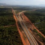
In Central Java, the Semarang to Demak section is a prominent example. The 6.7 kilometer coastal defense is being built to double as a toll road. Work began in 2023 and the project was reported at about half completion in early October. In built up zones, the design resembles a fortress, while less populated fringes are slated for softer defenses such as mangrove belts and set back zones.
Why parts of Java are sinking
Java’s north coast faces two forces at once, rising seas and sinking land. The first is driven by a warming climate that expands ocean water and melts land ice. The second is driven by human activity on shore. When groundwater is pumped faster than aquifers can refill, the soft clay layers beneath cities and factories compress. Streets, pipes, and building foundations slowly sink. Low lying districts that once stood just above the tides slip below the water line.
Indonesia’s meteorology and climate agency reports that average sea levels around the archipelago rose about 4.25 millimeters per year from 1992 to 2024, with signs of acceleration in recent years. In parts of north Java, subsidence has raced far ahead of the ocean rise. Surveys have found cumulative drops of the land surface measured in tens of centimeters in some neighborhoods, and up to two meters in the worst hit pockets, which magnifies flood risk.
Rapid urban growth and thirsty industry concentrated along the coast have long relied on deep wells. In many cities the piped water network does not yet serve every district at reliable pressure, so households and businesses default to pumping. Without a switch to surface water and tighter controls on groundwater extraction, relative sea level in these places will continue to rise faster than any natural shoreline can adapt.
These processes also change how rivers behave. As land sinks behind the shoreline, gravity drains lose efficiency, outfalls sit lower relative to the sea, and storm water is more likely to stall. Any wall that keeps tides out must therefore work with new pumps, detention ponds, and channels that give inland water a way out.
Leadership, money, and partners
The presidency has created a new body, the North Java Coast Management Authority, to steer planning, contracts, and operations. Didit Herdiawan Ashaf, a former senior navy officer and deputy minister of maritime affairs and fisheries, has been appointed to lead the authority. He is supported by two deputies, Darwin Trisna Djajawinata, who has experience in state owned investment, and Suhajar Diantoro, a former senior official at the Home Ministry.
President Prabowo Subianto has framed the seawall as essential public works and has argued that the effort cannot wait.
“Sea waters have threatened the lives of our people. One of the most vital infrastructure projects that we need to do promptly is the giant seawall across the northern Java coast.”
Funding will require an array of partners. Indonesia is seeking investment through a PPP model and has courted support from China, Japan, South Korea, and European partners that have coastal engineering experience. Talks are ongoing on how to split the build into phases that different investors can back. The Netherlands has long advised on polder style systems in Jakarta, Japan rebuilt many seawalls after the 2011 tsunami, and South Korea hosts one of the longest seawalls in Asia.
The long build horizon means governance choices matter. Supporters say a single authority can coordinate across provinces. Critics worry that another layer risks delays if it struggles to cut through competing permits and overlapping plans. Both agree that stable financing, realistic schedules, and regular maintenance must be locked in from the start.
Local gains and losses
For residents in inundated neighborhoods, a well designed barrier paired with pumps can mean dry floors, clean tap water, and streets that reopen for trade. Households that have lived with ankle deep tides for years view any protection as a lifeline. In places like Bedono village near Demak, daily routines such as cooking and commuting have carried on in water for almost a decade. People say even a partial reduction in flooding would bring relief.
For small scale fishers and coastal farmers, the picture looks different. Early sections have already reshaped currents and silt patterns. Fishers report reduced catches of fish, crabs, and mussels near construction zones. In some hamlets, fish farm operators say new embankments and access roads have altered the flow of brackish water that their ponds depend on. Communities that live by the tides worry that the wall could cut off their working grounds or force longer trips to open water, which raises fuel and safety costs.
Relocation is another pressure point. In Demak, at least three villages have already vanished to the sea, and more households face the decision to move inland. Local leaders have called for fair compensation, new housing plots on higher ground, and support to retrain workers whose jobs depend on coastal access. Without a social plan, residents fear being protected by the wall but left behind by the economy it seeks to save.
Environmental stakes and expert warnings
Conservation groups and urban planners argue that a hard barrier is a blunt tool in a dynamic delta. They warn that a continuous wall will change how sand and mud travel, curb the tidal flushing that keeps estuaries oxygenated, and make it harder for mangroves to migrate inland as the sea encroaches. The concern is that rivers hemmed in by embankments, then blocked at the mouth by coastal defenses during high tides, will store more polluted water upstream.
Researchers also point to dredging in harbors and near shore channels that feed fill material to construction sites. When disturbed silt settles on reefs and seagrass beds, it can smother the habitat that young fish need. A study by the Ministry of Marine Affairs and Fisheries in 2016 linked segments of the Jakarta coastal plan to measurable losses for local fishing households each year. Extending that footprint without new safeguards could multiply those losses.
Erwin Suryana of the People’s Coalition for Fisheries Justice has warned that the current plan answers the symptom while ignoring the deeper cause of flooding, sinking land from groundwater extraction. He said communities feel the brunt of that mismatch.
“The giant wall is a false solution that creates new hardships for people.”
Elisa Sutanudjaja of the Rujak Center for Urban Studies has also cautioned against treating one mega structure as a cure all. She has urged the government to stick to hydrology and to protect river mouths, wetlands, and mangrove belts in the design.
“If a wall blocks river mouths and bays, it can slow water flow to the sea, accelerate sedimentation, and make floods worse in the very districts the project intends to help.”
Jakarta as the test case
Jakarta is one of the fastest sinking large cities in the world. That is why the bay in the capital is slated as the first large build. Officials say a new sea defense there would integrate with upgraded water supply to reduce groundwater pumping, new pump houses at canals, and higher levees around storage lakes. The intention is to buy time for a city that sits on alluvial clay and a coastline that has dropped in places by several centimeters a year.
Local seawalls in Jakarta have already failed in the past. Breaches have flooded low lying wards and industrial zones. Those incidents underline a lesson from the Netherlands and other lowlands: protection is a system, not a single barrier. Pumps must have backup power, sediment must be managed, and operators must adjust to tides and storms in real time.
The Jakarta segment will carry an eight to ten year schedule and an estimated multibillion dollar budget. If it holds tides back, improves drainage, and reduces pumping of groundwater at the same time, it will be a strong signal that the broader plan has a chance to work. If it falters, it will be a costly warning.
What could complement the seawall
Engineers and planners often describe coastal safety as a mix of keep water out, keep water moving, and keep land from sinking. On Java’s north coast, that mix starts inland. Expanding reliable piped water and surface water treatment can reduce the need for deep wells. Enforcing groundwater permits, pricing extraction, and sealing illegal taps can slow subsidence. Industries in flood prone zones can be steered toward recycled water and closed loop cooling to cut demand.
Nature can help absorb energy from waves and trap sediment. Restoring mangrove forests and allowing them to migrate inland where possible builds a rough, living edge in front of any wall. Reconnecting rivers with floodplains in upstream basins can shave the peak off storm flows before water reaches the coast. Dredging policies can be rewritten to cut plumes and protect seagrass and coral nursery areas.
Some districts will still need managed retreat. That means mapping the most at risk neighborhoods, buying land inland, and building new homes, schools, and clinics before families move. Fishing communities can be offered new jetties and cold storage at safer harbors so that their sea access and earnings do not collapse.
Successful examples abroad hinge on trust. Project offices can publish contracts and weekly progress dashboards, take citizen input on alignments, and set up independent audits for environmental performance. A credible compensation program for fishers, farmers, and small businesses would turn contest into cooperation.
The stakes for industry and national economy
Java’s north coast holds dozens of industrial estates, five special economic areas, ports, fuel depots, and power plants. Many are within a few kilometers of the shore. Tidal floods already interrupt shifts, damage stock, and corrode machinery. Logistics corridors knit together toll roads, container yards, and export factories that depend on schedules measured in hours, not days. Repeated inundation erodes that foundation.
A functioning coastal defense, tailored to each reach of shoreline, would reduce chronic losses and avoid emergency spending after each storm tide. It could keep warehouses dry, keep roads open to trucks, and limit saltwater intrusion into water treatment plants. That said, the wall will change the working sea for fishers and aquaculture farms. The people on the front line of any change need fair treatment, clear information, and a way to share in the benefits of safer ground.
What to Know
- Indonesia plans a giant seawall along the north coast of Java, with a length described between 500 and about 700 kilometers.
- The estimated cost is about US$80 billion and the build is expected to take 15 to 20 years in phases.
- Jakarta Bay is the first large segment, budgeted at roughly US$8 to US$10 billion with an eight to ten year timeline.
- A new authority, the North Java Coast Management Authority, has been formed to oversee planning and delivery.
- Sea level around Indonesia has risen about 4.25 millimeters per year since the early 1990s, while parts of north Java have sunk much faster due to groundwater extraction.
- The Semarang to Demak section, 6.7 kilometers long, also serves as a toll road and is under construction.
- Indonesia is seeking investors from China, Japan, South Korea, and European partners through a PPP model.
- Groups warn of risks to rivers, reefs, and fisheries, and urge stronger action on groundwater and mangrove protection.
- Some coastal communities welcome protection, while fishers and fish farmers report early losses near construction zones.
- Combining coastal defenses with water supply upgrades, managed retreat, and community compensation will decide how well the plan works for people and industry.