New risk range, same urgency
Japan has widened its estimate of the chance that a magnitude 8 to 9 earthquake will strike along the Nankai Trough within the next 30 years, setting the probability around 60 to 90 percent, or higher. The Earthquake Research Committee, a government panel, updated the figure after reexamining historical uplift records and the way uncertainty is handled in its models. Officials said the shift is about how the numbers are calculated, not a sign that a big quake is suddenly more likely this year.
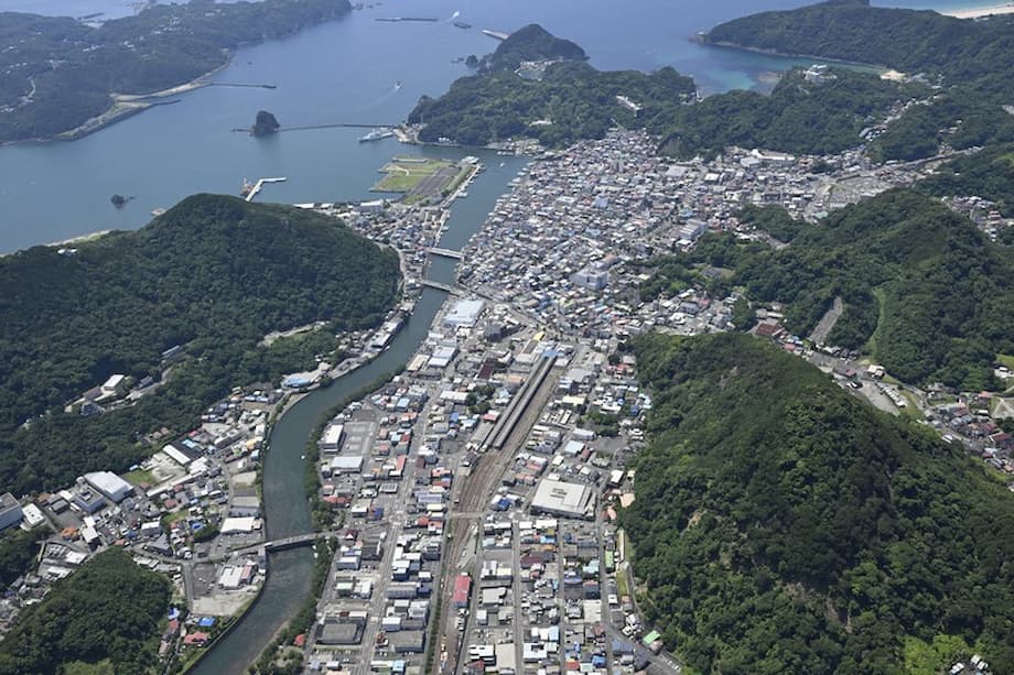
The committee also released a separate estimate of 20 to 50 percent that does not rely on uplift data. Members said both ranges are scientifically defensible, but they will emphasize the higher one in public messaging to keep communities focused on preparedness. The trough runs offshore from central Honshu past the Kii Peninsula and Shikoku to eastern Kyushu, where the Philippine Sea Plate dives beneath Japan. Great earthquakes along this boundary tend to recur every century or two, and the last pair were the 1944 Tonankai and 1946 Nankai events.
Naoshi Hirata, honorary professor at the University of Tokyo and head of the panel, stressed that earthquake timing cannot be fixed to a date. He said the priority is steady readiness rather than guessing the exact year.
“An actual earthquake is an unpredictable natural phenomenon. We can’t clearly say when it will happen. It may be more than 30 years away but may come within a year.”
Risk estimates for the Nankai segment have crept higher over the last decade as time passes without a rupture. The panel put the chance at 60 to 70 percent in 2013, then about 80 percent in early 2025. The new approach widens the range to reflect errors in old measurements and variability in how stress builds on the fault.
Authorities continue to warn that a powerful quake and tsunami along this coast could kill hundreds of thousands of people, inundate wide swaths of shoreline, and trigger cascading impacts on industry and infrastructure. The government has modeled worst case scenarios to guide land use, evacuation planning, and investment in seawalls, shelters, and early warning.
Why the probability changed
Two technical issues drove the revision. First, researchers found that historical records from Muroto Port in Kochi Prefecture, long used as a proxy for how the coast rose and fell between past megaquakes, include errors and site changes that skewed previous calculations. Second, the assumption that strain accumulates at a steady pace across the plate boundary does not always hold. The new method explicitly accounts for these uncertainties, which widens the probability band. In the committee’s technical report, the upper bound reaches about 94.5 percent.
From tide gauges to models
For decades, estimates leaned on the timing of past ruptures and on uplift observed at a handful of coastal sites. That limited dataset helps, but it can give a false sense of precision. The committee now combines a time dependent view, which tracks how long it has been since the last event, with statistical treatments that reflect measurement error and year to year variability in stress loading. With more uncertainty baked in, the result is a broader range, not a sharp point estimate.
Dual estimates and public messaging
A separate calculation that ignores uplift data and looks only at average intervals between large events yields a lower 20 to 50 percent range. Panel members said neither method is clearly superior given the small sample of observed megaquakes. They said they plan to stress the higher range because communities on the Pacific side face life threatening tsunamis and strong shaking when the next rupture comes.
Communicating two numbers, and what they do and do not mean, is a challenge. Naoya Sekiya, a University of Tokyo scholar who studies disaster information, cautioned that numbers alone are not enough for the public.
“When experts communicate such information, they need to present what disaster-preparedness steps can be taken.”
That focus is consistent with how the panel framed the revision. The change clarifies uncertainty, but it does not alter the core message for residents, businesses, schools, and local governments along the coast.
What a Nankai megaquake could do
Government planning documents describe a magnitude 8 to 9 rupture along the trough that could generate towering tsunamis and widespread shaking. A national estimate released in March projected up to about 298,000 deaths in a worst case event and economic losses on the order of 292 trillion yen. Coastal communities in Shizuoka, Aichi, Mie, Wakayama, Tokushima, Kochi, and Miyazaki would face the greatest tsunami danger, while major cities including Nagoya and Osaka could suffer heavy damage to housing, ports, and supply chains.
Records show that the 1707 Hoei earthquake, the largest known along this zone, sent waves tens of meters high into parts of Shikoku, Kii, and Kyushu. In 1854, two major ruptures struck the region within days. In 1944 and 1946, separate Tonankai and Nankai events again hit in quick succession. Engineers and hazard planners prepare for both a single massive rupture that breaks multiple segments and sequences where one segment fails then loads another.
Tsunami timelines and evacuation windows
Tsunami travel times will be short for many low lying districts. In near field areas, the first major wave could arrive within minutes of strong shaking. That is why towns across the Kii Peninsula and Shikoku have built vertical evacuation towers and posted high ground routes. Sirens, smartphone alerts, and local radio play a role, but personal recognition of natural signs, long shaking or a sudden water retreat, is the fastest trigger for evacuation.
Beyond Japan, tsunami energy would spread across the Pacific. Modeling indicates that a very large rupture could send wave trains toward Taiwan, the Philippines, and areas farther south. Travel times increase with distance, which gives national meteorological services time to issue warnings.
History and stress cycle along the trough
Large events along the Nankai system recur on a scale of about 90 to 150 years, sometimes as paired ruptures, sometimes as a single break. Roughly eight decades have passed since 1946, which is one reason the committee’s recurrence models have trended higher as the calendar advances. Yet the planet does not follow a clock. There have been instances where expectations built for decades before a sudden release, and other periods where stress lingered longer than expected.
Advisories after strong regional quakes
In August 2024, a magnitude 7.1 earthquake in the Hyuga Sea off Kyushu triggered the first use of a megaquake advisory under a system adopted in 2019. The Japan Meteorological Agency convened experts, raised an alert to urge extra caution for a week, then lifted it when signs of escalation did not persist. The advisory was not a prediction. It flagged an elevated state that warranted vigilance while admitting the limits of present knowledge.
That episode led to transport delays, event cancellations, and a run on some staples as people stocked up. It also exposed confusion about what the label meant. The panel’s new communication strategy aims to pair clearer probability language with practical steps.
How authorities and communities are preparing
National and local governments are trying to compress evacuation times and protect critical services. A preparedness plan released in early July outlined faster construction of sea embankments and tsunami evacuation buildings, more frequent drills, mutual aid agreements across prefectures, and better backup power for hospitals and data centers. Port authorities and manufacturers are revising continuity plans to minimize the shock to shipping and production.
What households can do now
Preparedness at home and work is the last line of defense. Local hazard maps show inundation zones and evacuation sites. Emergency kits should cover water, food, flashlights, medicines, and copies of key documents. Furniture and appliances can be anchored to cut injuries during shaking, and families should practice getting to high ground.
- Know the nearest high ground or vertical evacuation site and two routes to reach it.
- Keep at least three days of water and shelf stable food per person, more if you live in remote areas.
- Anchor bookcases, TVs, and gas appliances, and secure cabinet latches.
- Carry a small grab bag with a flashlight, portable radio, batteries, whistle, and basic first aid.
- Agree on a family reunion plan and an out of area contact.
Japan’s earthquake early warning can provide a few seconds of notice before strong shaking begins, which is enough to duck under a sturdy table, hit an emergency stop, or open platform doors. Local tsunami alerts follow quickly when a large offshore rupture is detected.
International ripple effects
Agencies outside Japan monitor the Nankai risk because of potential tsunami effects and supply chain disruptions. The Hong Kong Observatory notes that a distant Nankai event would not shake Hong Kong, but a very large tsunami could create sea level anomalies several hours later. For a shallow magnitude 9 class rupture, wave energy could reach southeastern Hong Kong waters about six hours after the event, with impacts shaped by local seabed and harbor design.
Maritime routes across the Philippine Sea and the approaches to Tokyo Bay, Osaka Bay, and the Seto Inland Sea would face temporary closures. Energy infrastructure, including LNG import terminals and refineries on the Pacific coast, could sustain hits that ripple through regional markets.
Reading the new numbers wisely
Probabilistic forecasts describe chances over a period. A range of around 60 to 90 percent over 30 years means the hazard is high during that window, not that the quake will occur in a specific year. The panel’s figures have ticked up slowly, less than one percentage point each year, as time since 1946 grows. The aim of publishing the wider range is to place the uncertainty on the table so planners can stress test systems and the public can prepare without panic.
Public attention spiked during the 2024 advisory when some store shelves emptied. That reaction reflects the stakes along this coastline, home to major ports and millions of residents. Clear information and practical guidance can help channel concern into preparation rather than fear.
At a Glance
- Government panel widened the 30 year Nankai megaquake probability to around 60 to 90 percent, or higher, with a separate method giving 20 to 50 percent.
- Revision reflects errors in historical uplift records at Muroto and nonconstant strain on the plate boundary, not a sudden jump in hazard.
- Panel plans to emphasize the higher range to keep preparedness front and center.
- Recurrence along the trough is about 90 to 150 years. The last events were in 1944 and 1946.
- Worst case modeling projects up to about 298,000 deaths and economic losses near 292 trillion yen, with tsunamis over 20 meters in some areas.
- Japan’s advisory system can issue temporary alerts after strong regional quakes. These are cautionary, not predictions.
- Governments are accelerating embankments, evacuation buildings, drills, and power backups for critical services.
- Households are urged to know evacuation routes, secure furniture, and keep multi day supplies.
- International monitoring notes possible minor tsunami effects in distant regions several hours after a very large event.


