
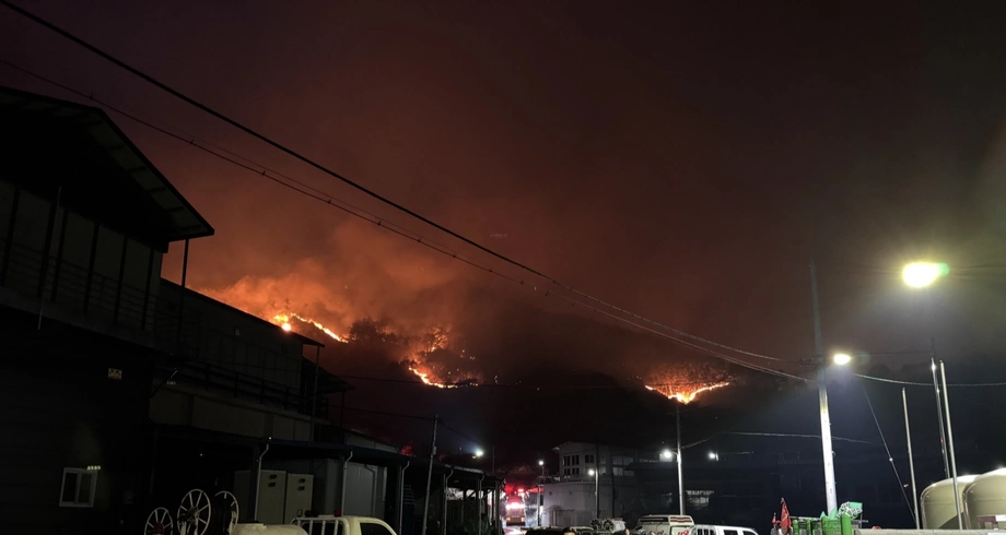
Three days that exposed a growing danger
South Korea's record March 2025 wildfires coincided with three days when fire weather surged from below its seasonal average about a week earlier to exceptionally dangerous levels. An observational analysis of weather, satellite vegetation measurements and forest records identifies March 22–24 as the strongest such sequence in a record spanning 1981–2025.
Contents
- Three days that exposed a growing danger
- How the fires spread through southeastern Korea
- Why the damage estimate grew so much
- What made the weather so dangerous?
- Why tenfold and twofold describe different findings
- A landscape ready to burn earlier in spring
- The warning hidden in a single week
- Homes, older residents and heritage bore the losses
- Recovery must address the next emergency too
- Key Points
The analysis estimates that fire weather as severe as the 2025 event had become roughly ten times more likely when comparing the climates of 1971–2000 and 1991–2020. A separate World Weather Attribution study, using a different measure and climate comparison, estimated that human activity had made the hot, dry and windy conditions about twice as likely and 15% more intense.
The disaster's scale was enormous. The Korea Forest Service's forest damage assessment put provisional damage at about 104,000 hectares across North Gyeongsang, South Gyeongsang and Ulsan. The observational analysis used an approximate burned area of 105,000 hectares and estimated economic losses of around US$700 million across North Gyeongsang.
World Weather Attribution recorded 32 deaths, 45 injuries, approximately 37,000 displaced residents and around 5,000 buildings destroyed. Together, the findings describe a disaster shaped by rising temperatures, vegetation available earlier in spring, an exceptional burst of wind and communities exposed along forest edges.
How the fires spread through southeastern Korea
NASA's satellite account dates the first ignitions to March 21. More than a dozen fires broke out on March 22 and 23, according to World Weather Attribution, creating several emergencies at almost the same time.
Thousands of personnel and more than 100 helicopters were deployed. Mountainous terrain and strong winds complicated suppression, while highway sections and a railway line closed. The sequence shows how quickly the emergency grew:
- March 21–22: Fires began, and officials issued strong wind advisories for several counties.
- March 22: NASA's Aqua satellite captured smoke plumes. The Sancheong fire had burned more than 500 hectares by that evening.
- March 22–24: The observational analysis identified three consecutive days of rapidly intensified, extreme fire weather.
- March 25: Gusts exceeded 27 metres per second, according to weather observations cited by the Korea Forest Service.
- March 28–April 15: Local authorities and a joint government team carried out successive damage surveys.
The March 25 gusts exceeded 97 kilometres per hour. At those speeds, wind can drive flames forward and carry burning fragments beyond the main fire, starting new blazes ahead of crews.
Why the damage estimate grew so much
The Korea Forest Service recorded 99,289 hectares of provisional forest damage in North Gyeongsang, 3,397 hectares in South Gyeongsang and 1,190 hectares in Ulsan's Ulju district. North Gyeongsang therefore accounted for about 96% of the combined regional total.
Within North Gyeongsang, Uiseong recorded 28,853 hectares of damage, Andong 26,709, Cheongsong 20,655, Yeongdeok 16,208 and Yeongyang 6,864. The approximately 105,000 hectares used in the observational analysis was about four times the 26,000 hectares burned during the previous worst recorded season, in 2000.
The Forest Service also explained an important difference between its damage survey and the 48,000 hectares mapped during firefighting. The earlier figure tracked the area inside observed fire boundaries to guide suppression. The later survey measured actual forest damage for recovery planning. World Weather Attribution's assessment used the earlier scale of more than 48,000 hectares.
Fast moving flames sometimes crossed areas and died out before an active boundary could be mapped. Strong winds and haze hampered observation equipment, while some trees died from heat after suppression. Field inspections captured those losses. The Forest Service said the Central Disaster and Safety Countermeasures Headquarters would determine the final area; its statement gave no date for that decision.
What made the weather so dangerous?
The observational analysis calculated the Canadian Fire Weather Index, or FWI, using daily maximum temperature, relative humidity, wind speed and rainfall from ERA5, a dataset that combines observations with a weather model to reconstruct past conditions.
FWI brings several ingredients of fire danger into one measure. During March 22–24, its values rose far above the seasonal average across much of South Korea, with the largest departures in the southeast, where damage was concentrated.
Heat, low humidity and wind worked together. Hotter air can draw more moisture from plants and fallen leaves. Low humidity increases that drying power. Wind supplies oxygen, pushes flames and carries embers into new areas.
June-Yi Lee, an atmospheric scientist at Pusan National University and the Institute for Basic Science, described the temperature anomaly during a briefing:
From March 22–26, the daily maximum average temperature in southeastern Korea averaged around 25°C, which was 10°C higher than the normal March average.
A large atmospheric pressure pattern helped sustain strong westerly winds and bring relatively dry continental air over Korea. Average westerly winds across the broader Asia Pacific sector had strengthened only weakly over recent decades, but the late March event was an exceptional surge.
Why tenfold and twofold describe different findings
The observational analysis estimated that the 2025 FWI severity corresponded to an event occurring, on average, about once every 23 years under the 1991–2020 climate, compared with once every 230 years under the 1971–2000 climate. Those estimates produce the roughly tenfold increase in likelihood.
A return period describes probability, rather than a timetable. An event with a return period of 23 years can happen in consecutive years, because each year presents another chance for the necessary conditions to coincide.
World Weather Attribution's fire weather study examined a different measure: the maximum Hot-Dry-Windy Index over five consecutive days in March across South Korea. This index multiplies wind speed by the atmosphere's drying power, calculated from temperature and humidity.
The group estimated that the observed combination would occur about once every 300 years in today's climate. Combining observations and climate models, it attributed a doubling of likelihood and a roughly 15% increase in intensity to human caused warming. Its comparison was with a cooler climate before industrialisation, rather than between two recent historical periods.
The two studies therefore answer different questions. The FWI analysis tracks changes between observed periods and examines how rapidly danger develops. World Weather Attribution uses models as well as observations to estimate the contribution of human caused climate change. Dedicated attribution experiments would be needed to assign that contribution to the observational study's tenfold change.
A landscape ready to burn earlier in spring
South Korea's early spring already combines lingering winter dryness with rapidly rising temperatures. The observational analysis found increases in early spring temperature and vapour pressure deficit over the fire region, with stronger trends in recent decades and across the burned area.
Vapour pressure deficit describes how much more moisture the air could hold before becoming saturated. A larger deficit means the atmosphere can pull water from vegetation more readily, helping explain why temperature and humidity matter together.
Satellite measurements also showed rising March vegetation activity over recent decades. The analysis used the Normalized Difference Vegetation Index, a satellite measure of vegetation greenness, to track that change.
Early spring plant growth in Korea is generally constrained by cold rather than a shortage of water. Warming can bring growth forward and increase vegetation available as fuel. Forest maturation after reforestation and plant responses to higher carbon dioxide concentrations may also contribute; the analysis leaves their individual shares unresolved.
The practical combination is more vegetation present earlier in the season and warmer air capable of drying fuel faster. The steep fall in vegetation greenness after the 2025 fires recorded the resulting burn scar.
The warning hidden in a single week
The observational analysis defined a rapid intensification day by comparing fire weather with its normal value for that time of year. A three day average had to rise more than one or two standard deviations above the daily average, after conditions six to eight days earlier had been average or lower. Standard deviation is a measure of how widely values normally vary.
March showed the largest increase in these rapid transitions over southeastern Korea during 1981–2025. Events meeting the more extreme threshold appeared mainly after 2000. March 2025 recorded three qualifying days, the highest monthly count in the 45 year record.
Breaking FWI into its components helped explain the speed of the change. The Initial Spread Index responds quickly to wind and the drying of small fuels such as needles and twigs. The Buildup Index tracks a longer memory of fuel dryness, developing over weeks to months.
The fast component reproduced the record March 2025 surge. The slower component recorded no rapid intensification days at the more extreme threshold anywhere in the study period. In 2025 it crossed the lower threshold only on March 25–28, after the fires had already spread.
Earlier drying still helped prepare the landscape. Wind and rapidly drying fine fuels supplied the sharp acceleration. For emergency planning, the finding directs attention to the speed of deterioration as well as the absolute danger level: relatively ordinary conditions can give way to an extreme episode within about a week.
Homes, older residents and heritage bore the losses
World Weather Attribution found that the fires hit rural and suburban areas particularly hard where forests bordered homes, industrial buildings and cultural sites. Many affected residents were older or had limited mobility, making evacuation more difficult.
Most people who died were in their 60s and 70s. Uiseong accounted for 26 deaths, while four occurred in Sancheong. Around 5,000 buildings were destroyed, including homes, factories and farms. Gounsa Temple, founded in 618, and other cultural heritage sites were also lost.
South Korea's restoration of forests since the 1970s brought benefits including reduced erosion, wildlife habitat and carbon storage. World Weather Attribution also identified continuous forest cover and accumulated fuel near settlements as concerns requiring careful management.
The weather findings connect directly to those local risks. When strong winds carry embers across roads or gaps in vegetation, residents may have less time to leave. Evacuation arrangements for people who need help and fuel management around buildings are therefore central parts of the response described in the attribution assessment.
Recovery must address the next emergency too
The Korea Forest Service completed emergency inspections at 4,207 locations vulnerable to secondary damage between March 28 and April 11. Burned slopes can expose communities to landslides and soil runoff, while damaged trees threaten homes and essential facilities.
The agency outlined emergency repairs, removal of dangerous trees and restoration methods chosen according to damage, including natural recovery, ecological restoration and planting. It also planned restoration councils involving residents, forest owners and specialists, alongside a recovery master plan supporting local livelihoods.
Fire monitoring is another priority. The Forest Service proposed discussions on overlapping observation systems using fixed wing aircraft, drones operating at medium and high altitudes, and satellite imagery to improve coverage during strong winds and haze.
World Weather Attribution projected that another 1.3°C of global warming from today's level would increase the peak March Hot-Dry-Windy Index by about 5% and double the likelihood again. Its study associated that warming level with around 2100 under current policies. The observational analysis, meanwhile, calls for testing whether forecasting systems can anticipate the combination of warmth, dry fuels and sudden wind bursts.
Uncertainty remains around rainfall: World Weather Attribution found a slight drying trend before the fires, but could not assign it to human activity or natural variability. The operational challenge is already concrete, preparing communities for extreme fire weather that can develop rapidly while recovery from the last disaster continues.
Key Points
- The Korea Forest Service assessed provisional forest damage at about 104,000 hectares, concentrated in North Gyeongsang.
- World Weather Attribution recorded 32 deaths, 45 injuries and about 37,000 displaced residents.
- March 22–24 brought a record three days of rapidly intensified fire weather in the observational analysis.
- The tenfold historical change in FWI likelihood and the twofold climate attribution estimate use different measures and comparisons.
- Rising temperatures, earlier vegetation activity and exceptional winds combined to increase danger.
- Recovery priorities include slope safety, damaged trees, forest restoration and stronger monitoring during severe weather.