
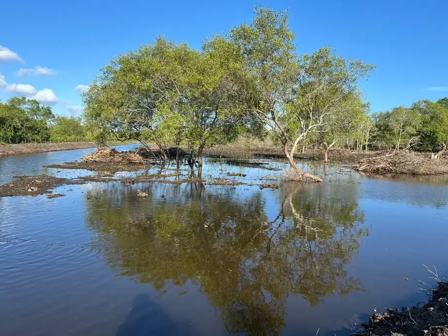
A lagoon reduced to a fraction of its former size
Segara Anakan, the lagoon between Java and Nusakambangan island in Indonesia, lost about 90% of its water area between 1978 and 2020. Figures from the National Research and Innovation Agency, known as BRIN, show that the lagoon and its channels shrank from 4,150 hectares to about 400 hectares. Along its shores, residents are planting mangroves while rivers continue to deliver the mud that is turning their fishing grounds into land.
Contents
- A lagoon reduced to a fraction of its former size
- How rivers are turning water into land
- Why mangrove planting alone cannot restore the lagoon
- Fishing families face a different landscape
- A shrimp boom, a collapse and a community response
- Research joins the restoration effort
- The disputed plan to divert the Citanduy
- Dredging removes less mud than the estimated annual deposit
- What can still be protected?
- Key Points
The danger is particularly acute in the western lagoon. A 2024 sedimentation study by T. N. Cahyo and colleagues found that more than 85% of that area had filled with sediment over 161 years. Its projection placed the transformation of the western lagoon into land crossed by waterways around 2032, calculated from conditions in 2018.
Other researchers give different time estimates. Erwin Riyanto Ardli, a lecturer at Jenderal Soedirman University's Faculty of Biology, estimates that the lagoon could disappear in 10 to 15 years, leaving small channels. BRIN researcher Suyadi anticipates a similar transformation over about 30 years. Their shared warning is that broad stretches of open water are giving way to a much narrower network of rivers.
For Kampung Laut residents, that change is already shaping daily life. Fish catches have fallen, abandoned shrimp ponds occupy former mangrove forest, and some fishing families have turned to farming. Community leader Thomas Heri Wahyono estimates that only about 350 hectares of water now remain, compared with BRIN's measurement of 400 hectares in 2020.
How rivers are turning water into land
The Citanduy River carries the largest sediment load into Segara Anakan. Soil and mud travel downstream, enter the lagoon and settle on its bed. As deposits accumulate, shallow areas become exposed land, changing both the movement of water and the places where plants and animals can live.
Estimates cited for the Citanduy's share range from 70% to 80%, while a 1994 Engineering Consultants Inc. study put its contribution above 86%. That study estimated that rivers carried 5.77 million cubic metres of sediment into the area annually. About 4.77 million cubic metres continued to sea, leaving roughly one million cubic metres in the lagoon.
Deforestation and farming practices that expose soil to rain have increased erosion upstream. The lagoon also has a much longer history of receiving sediment. A 2009 research synthesis, published on May 8 in Regional Environmental Change, described heavy sediment input as a process operating for centuries, with recent human activity adding pressure. It also identified a volcanic eruption and conversion of mangroves to other uses among the contributors to habitat loss.
The 2024 study measured an average loss of 61 hectares of water area annually in the western lagoon and reported shoreline expansion of 177 hectares a year during 1999 to 2003. Those figures describe different changes: one measures disappearing water, while the other tracks land advancing along the shore.
Why mangrove planting alone cannot restore the lagoon
Mangrove forest covered about 19,000 hectares around Segara Anakan in the 1970s. BRIN's figures put the remaining area at 4,414 hectares in 2020, a reduction of roughly 77%. Logging, shrimp ponds, farmland and settlements have all taken space once occupied by forest.
Sediment also changes the forest itself. Mangroves need suitable combinations of tidal flooding, salt and soil conditions. As land rises and water circulation changes, some mangrove trees struggle while other plants spread. Ardli and Suyadi identify the climbing plant Derris trifoliata as a particular problem in heavily altered areas.
A land cover study using SPOT 4 imagery from 2008 and Sentinel-2A imagery from 2019 found declining mangroves and water bodies alongside expanding settlements and farmland. Researchers used vegetation measurements and computer classification to distinguish different types of land cover. In heavily sedimented habitats, Acanthus and Derris dominated, followed by Nypa palms.
The SPICE research programme, whose findings were summarized in 2009, had already found fewer mangrove seedlings and smaller stem diameters than in the 1980s. Tree cutting and heavy sedimentation were major causes. Protecting and planting trees therefore addresses one part of a wider problem: the land and water conditions supporting the forest are changing too.
Fishing families face a different landscape
Wahyono remembers growing up in Motean hamlet, Ujungalang village, during the 1970s, when houses stood on stilts among thick mangroves. Children swam, residents caught fish and shrimp in abundance, and dolphins passed through the water. He recalls occasional whales as well. Dolphins and whales are no longer seen there.
Bono Lasto Priono stopped fishing in 2020 after catches kept declining. Local recollections put some daily catches in the 1980s at 100 kilograms; today, residents describe difficulty catching even one kilogram. Priono now helps plant mangroves and patrols against illegal cutting.
The land cover research connects the expansion of farmland with a shift from fishing to agriculture. Farming brings its own uncertainty because the salt content of the water changes with the seasons. A farmer expecting fresh water during the rainy season can lose a crop when actual conditions are saltier than anticipated.
New land has also changed village geography. Wahyono moved with his family to Lempong Pucung in the early 1990s, settling on ground created by sediment. Klaces village, once surrounded by water, is now connected to Nusakambangan. Residents along rivers, including in Kawunganten and Sidareja, face more frequent flooding as waterways become shallower.
A shrimp boom, a collapse and a community response
Rising shrimp prices triggered a pond boom in 1994. Investors arrived from other regions, and thousands of hectares of mangroves were cleared. Wahyono also tried shrimp farming. About four years later, disease killed the shrimp, and by 1999 the local pond business had collapsed, leaving residents without income and cleared land behind.
Wahyono began planting mangrove seedlings around abandoned ponds that year. His first group, Kelompok Keluarga Lestari, consisted of himself and six family members. By 2005 it had grown to more than 20 people and adopted the name Krida Wana Lestari.
By 2024, Wahyono's arboretum covered seven hectares and held 35 mangrove species. He estimates that Kampung Laut contains at least 56 species. The group also promotes mangrove products, including snacks and batik, and develops tourism to give residents more ways to earn a living.
Krida Wana Lestari and an associated lagoon conservation group received orders for 1.25 million seedlings in 2024. More than 100 people now participate in forest restoration and related economic activities. The work has required negotiation with residents who need land for crops or expect planting to provide immediate income.
Research joins the restoration effort
BRIN and Krida Wana Lestari signed a research agreement online on July 5, 2024. In its July 2024 announcement, the agency described cooperation lasting five years on mangrove conservation, restoration and community assistance. BRIN said intensive research at Segara Anakan had been under way since 2019.
Asep Hidayat, head of BRIN's Research Center for Ecology and Ethnobiology, outlined plans to use radar or satellite imagery and drones to improve management of areas maintained by the group. The agreement connects residents' knowledge and access to planting areas with researchers' ability to track ecological changes.
BRIN also identified pollution and invasive species among the lagoon's threats. Earlier SPICE research showed why different pressures need different responses. Water generally moved through the shallow lagoon quickly, helping keep nutrient concentrations moderate to low compared with lagoons suffering severe nutrient pollution, despite intensive agriculture upstream.
The same research found unusually rich communities of animals living on or in the lagoon bed compared with other Southeast Asian mangroves. Protecting Segara Anakan means retaining those surviving habitats while supporting residents whose livelihoods depend on them.
The disputed plan to divert the Citanduy
The largest proposed intervention was a canal about three kilometres long that would send Citanduy water and sediment directly to the sea near Nusawere, east of Pangandaran, bypassing Segara Anakan. Its appeal in Cilacap was straightforward: less sediment would enter the lagoon. Fishing and tourism groups in Pangandaran feared that mud and rubbish would instead damage their coastal waters and incomes.
The proposal became part of the Segara Anakan Conservation and Development Project, or SACDP, supported by an Asian Development Bank loan. Plans also included diverting the Cimeneng River, dredging 600 hectares of lagoon, improving 20 kilometres of river channels, rehabilitating 1,125 hectares of mangroves, aquaculture trials and village infrastructure.
The project's long history shows how environmental engineering became entangled with competing local needs:
- 1996: The government began SACDP with Asian Development Bank financing.
- 1999: The planned Citanduy diversion was delayed amid opposition and further review.
- 2002: Cilacap fishers travelled to the Environment Ministry in Jakarta to demand action.
- 2004: The extended SACDP programme ended without resolving the diversion dispute.
- 2024: The Pangandaran branch of the Indonesian Fishers Association asked the Citanduy river authority to reassess the proposal.
Research involving ITB, IPB and Padjadjaran University concluded that both proceeding with and abandoning the diversion carried risks, but assessed the diversion's risks as smaller. The Environment Ministry gave conditional approval to the environmental impact assessment, including a requirement for local governments to resolve the conflict between communities.
Dredging removes less mud than the estimated annual deposit
The Citanduy River Basin Authority began dredging in 2017. Removal increased from 45,000 cubic metres that year to 536,096 cubic metres in 2022. That is almost twelve times as much, yet still only about 54% of the estimated one million cubic metres deposited annually.
A sediment modelling paper describes that annual deposit estimate using MIKE21, a computer model of water and sediment movement. It represents horizontal movement in two dimensions and simulates a year of changes to the lagoon bed. Because the deposits consist mainly of mud, the model accounts for fine particles that stick together.
The comparison explains why dredging has struggled to keep pace. Against that estimated annual deposit, the 2022 removal volume leaves a gap of about 464,000 cubic metres. Actual accumulation varies with river flows, tides and where sediment settles, but the scale of the task is large.
Hendra Ahyadi, then head of the river basin authority, described dredging as a temporary response and called for coordinated action involving ministries and local governments. Reducing erosion upstream would address incoming material, while dredging removes sediment already deposited.
What can still be protected?
Cilacap environment agency head Sri Murniyati says her office lacks the budget and authority to manage forests and marine waters. The administrative problem crosses provincial boundaries: Segara Anakan lies in Central Java, while much of its sediment arrives through rivers flowing from West Java.
Cilacap has twice proposed designating Segara Anakan an Essential Ecosystem Area. No decision or timetable for that designation was given, and the renewed diversion request has no announced construction date. Sri says companies are more interested in financing mangrove restoration than dredging.
Muhammad Yusuf, deputy chair of the Indonesian Fishers Association in Pangandaran, now supports reconsidering the diversion after seeing sedimentation's effects. Ardli believes it is already too late for the canal to save most of the lagoon because so much has filled with mud. Suyadi argues that restoring upstream environments can still slow sediment delivery.
The practical goal is becoming narrower but remains substantial: retain waterways, protect surviving habitat, restore suitable mangrove areas and sustain local incomes. Residents can plant trees and prevent cutting. Controlling sediment across an entire river basin requires action far beyond their villages.
Key Points
- BRIN figures show Segara Anakan's water area fell from 4,150 hectares in 1978 to about 400 hectares in 2020.
- A 2024 study projected that the western lagoon could become sediment filled land crossed by waterways around 2032.
- Dredging removed 536,096 cubic metres in 2022, compared with estimated annual deposition of about one million cubic metres.
- Community groups received orders for 1.25 million mangrove seedlings in 2024 and involve more than 100 people in restoration and related work.
- BRIN and Krida Wana Lestari signed a cooperation agreement lasting five years in July 2024.
- The Citanduy diversion remains disputed, while researchers call for upstream restoration and protection of surviving mangroves.