
Banda Sea earthquake sends residents out of their homes
A magnitude 6.6 earthquake struck the Banda Sea west-southwest of Tual, Indonesia, early on Tuesday, November 17, 2026, sending some residents out of their homes and producing tremors across northern Australia. Indonesian authorities said the earthquake had no tsunami potential, while Australia's Bureau of Meteorology said there was no tsunami threat to its mainland or islands.
Contents
- Banda Sea earthquake sends residents out of their homes
- Why agencies gave different measurements
- What happened during the first morning
- How people experienced the shaking
- Why authorities ruled out a tsunami
- Hundreds felt tremors in northern Australia
- Rescue teams remain ready while checks continue
- What residents were advised to do
- Key Points
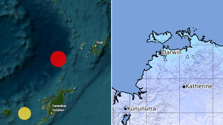
The United States Geological Survey placed the earthquake 148 kilometers from Tual, at a depth of 68 kilometers. Its recorded origin time was 21:11 UTC on Monday, November 16, equivalent to 6:11 a.m. Tuesday in eastern Indonesia. The time difference explains why the earthquake was initially described as occurring on Monday.
Indonesia's Meteorology, Climatology and Geophysical Agency, known as BMKG, measured the earthquake at magnitude 7.1. Emergency agencies were checking affected communities, with no deaths or building damage reported in their initial updates. A final assessment of injuries and damage was not yet available.
Tual residents felt shaking for about three to five seconds, while people in the Tanimbar Islands and Maluku Tenggara experienced roughly 10 seconds, according to information released by Indonesia's National Disaster Management Agency, BNPB. Some people rushed outside, although conditions in Tual were later described as calm.
The USGS issued a Green alert for estimated deaths and economic losses, indicating a low likelihood of casualties and damage. Its shaking estimates suggested about 8,100 people experienced intensity V, described as moderate shaking, and a similar number experienced intensity IV.
Why agencies gave different measurements
The USGS located the epicenter at 6.08 degrees south and 131.49 degrees east. The epicenter is the point on the Earth's surface directly above where an earthquake begins; depth describes how far below that surface the rupture starts.
Alongside the USGS estimate of magnitude 6.6 at 68 kilometers deep, BMKG gave magnitude 7.1, with Indonesian updates citing depths of 115 kilometers and 97 kilometers. The latter BMKG analysis placed the epicenter 132 kilometers southwest of Maluku Tenggara. Other initial accounts attributed a depth of 35 kilometers and a distance of 151 kilometers from Tual to the USGS, while Geoscience Australia gave a depth of 42 kilometers.
Earthquake measurements can change as agencies process more seismic signals. Different monitoring networks and calculation methods can also produce different estimates. For residents, the practical information was the shaking experienced locally, the tsunami assessment and the condition of nearby buildings.
What happened during the first morning
Indonesian emergency agencies began coordinating soon after the earthquake. Search and rescue officials contacted local disaster management teams to check conditions and prepare personnel in case assistance was needed.
- November 16, 21:11 UTC: The earthquake occurred beneath the Banda Sea, according to the USGS.
- November 17, 6:11 a.m. eastern Indonesian time: The same earthquake struck on Tuesday morning locally, equivalent to 4:11 a.m. in Jakarta.
- 6:25 a.m. eastern Indonesian time: The Ambon search and rescue office coordinated with disaster officials in Maluku Tenggara.
- 6:35 a.m. eastern Indonesian time: Coordination continued with the Banda search and rescue post.
- 4:25 a.m. Jakarta time: BMKG said its monitoring had detected no aftershocks by that update.
The Bureau of Meteorology placed the earthquake at about 6:41 a.m. Darwin time, matching the USGS origin time after conversion. Another account citing Geoscience Australia gave 6:11 a.m. for the Australian reports.
Search and rescue personnel remained on standby as local agencies continued checking communities. No later scheduled briefing or deadline for a completed damage assessment was announced.
How people experienced the shaking
Residents in the Tanimbar Islands and Maluku Tenggara described a short but forceful disturbance. BNPB said some people panicked and left their homes during the approximately 10 seconds of shaking. Local disaster management offices, known as BPBD, monitored conditions afterward.
Berton Panjaitan, acting head of BNPB's disaster data, information and communication center, said the agency had not received building damage reports when it issued its initial account. Checks were still under way.
BMKG recorded intensity III on the Modified Mercalli Intensity scale in Tual, Saumlaki, Tiakur, Dobo, Sorong, Manokwari, South Manokwari, Bintuni, Fakfak and Kaimana. Intensity II was reported in Nabire and Serui. Intensity III generally means shaking is noticeable indoors, sometimes resembling the vibration of a passing truck. At intensity II, only some people feel it, and hanging objects may sway.
Magnitude measures the size of an earthquake at its source. Intensity describes its effects at a particular place. A single earthquake therefore has one estimated magnitude from each agency's analysis but can produce many different shaking intensities across a region.
Why authorities ruled out a tsunami
BMKG's tsunami modeling indicated that the earthquake had no tsunami potential. The Bureau of Meteorology separately said no part of Australia's mainland or islands faced a tsunami threat.
Lana Saria, head of Indonesia's Geological Agency, attributed the absence of a tsunami to the earthquake's intermediate depth and a fault movement dominated by sideways slipping. The agency expected little deformation of the seabed.
A tsunami can form when movement beneath the sea displaces a large volume of water. In this event, the Indonesian analysis described rocks mainly sliding sideways along a fault, rather than lifting or dropping a broad section of the seabed.
BMKG Director of Earthquakes and Tsunamis Wijayanto said the earthquake involved deformation of rock within the Banda Sea Plate. The Geological Agency described it as likely associated with movement inside a slab in the Banda Sea subduction zone. A slab is a section of a tectonic plate that has sunk beneath another plate.
The tsunami assessment allowed coastal communities to focus on checking their surroundings and following local safety instructions. Authorities still advised residents to avoid buildings with cracks or other damage.
Hundreds felt tremors in northern Australia
Geoscience Australia received more than 460 reports from people who felt the earthquake. Reports extended across Darwin, Palmerston and surrounding rural areas, as well as Katherine, Jabiru, Maningrida, Milingimbi and Nhulunbuy. Weak shaking was also reported in Kununurra, Western Australia.
Darwin residents generally reported light shaking. Nine felt reports were recorded around Katherine during the reporting period. These submissions help map where people noticed movement and how strong it felt at each location.
Tanja Pejic, a seismologist at Geoscience Australia, described the earthquake as relatively shallow and widely felt. She identified the main clusters of public reports:
"We've received in excess of 450 felt reports so far, mostly coming from Darwin, Katherine and Nhulunbuy, and we've got a couple in Kununurra as well," she said.
Pejic explained that the Australian tectonic plate is moving north toward Indonesia and sinks beneath another plate in the Banda Sea region. Movement where plates meet, or within the descending plate, releases energy that travels through the Earth as seismic waves.
Some Australian residents described only seconds of movement. Toni, a resident of Katherine, said the tremors lasted "maybe 10 seconds at the most". Pejic said people on upper floors can feel more movement because the upper parts of tall buildings sway.
Rescue teams remain ready while checks continue
Indonesia's National Search and Rescue Agency, Basarnas, placed personnel in Maluku on standby. Edy Prakoso, its deputy for operations, said the Ambon office was coordinating with local authorities and rescue posts to assess conditions and maintain readiness.
Basarnas had received no reports of deaths or building damage in its Tuesday morning update. Its teams continued monitoring so that search and rescue operations could begin quickly if an emergency developed.
The Geological Agency said land nearest the epicenter includes flat and rolling terrain with sedimentary rocks and ground classified as medium soil. Much of the area falls within zones of medium to high earthquake hazard.
Those local conditions matter because soil and rock affect how shaking travels through the ground. The agency advised residents to inspect buildings, keep evacuation signs and routes usable, and stay away from cliffs vulnerable to ground movement, particularly during rain.
What residents were advised to do
BMKG urged people to remain calm, follow reliable official updates and avoid cracked or damaged buildings. Local BPBD offices were the point of contact for instructions based on conditions in each community.
Pejic advised people who experience shaking to use the "drop, cover and hold" routine. This means lowering yourself onto your hands and knees to reduce the chance of falling, taking cover beneath a sturdy table if possible, and holding on while protecting your head and neck.
Residents returning indoors were being asked to check the structure of their homes. The Geological Agency also called for earthquake resistant construction and evacuation routes in settlements and infrastructure in areas exposed to earthquake hazards.
The immediate task for authorities was to complete checks across the affected islands and towns. For residents, the practical priorities were to follow local instructions, stay away from damaged structures and keep access routes clear for emergency teams.
Key Points
- The USGS measured the Banda Sea earthquake at magnitude 6.6, 148 kilometers west-southwest of Tual; BMKG measured it at magnitude 7.1.
- The earthquake occurred on Monday evening UTC and Tuesday morning, November 17, in eastern Indonesia.
- Indonesian authorities found no tsunami potential, and Australia declared no tsunami threat to its mainland or islands.
- Initial emergency agency updates reported no deaths or building damage, with local checks continuing.
- Residents in parts of Maluku left their homes, while more than 460 people in Australia submitted felt reports.
- Rescue teams remained on standby, and authorities advised people to avoid damaged buildings and follow local safety instructions.