
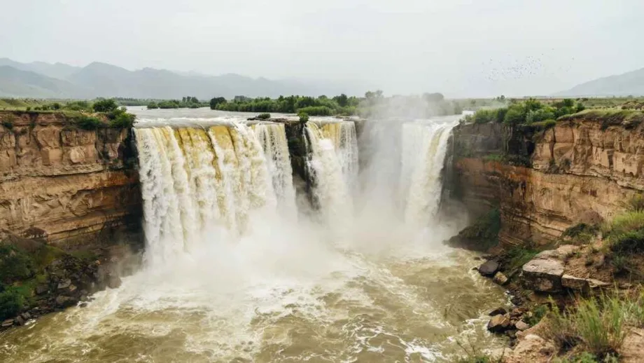
From muddy torrents to clearer cascades
The share of Yellow River Basin monitoring sections with good water quality rose from 59.1 percent in 2016 to 93.2 percent in 2025, according to the Yellow River Conservancy Commission (YRCC). At Hukou Waterfall in Jixian County, Shanxi Province, photographer Lyu Guiming has watched that wider transformation take visible form in the cascading water.
Contents
- From muddy torrents to clearer cascades
- What the water quality figures show
- Keeping soil on the land
- Reservoirs manage water and sediment together
- Flood protection remains a central task
- A flowing river in a region short of water
- Why allocation matters to food production
- Wetlands and tourism share in the change
- How eight decades of management developed
- Key Points
Lyu has photographed the waterfall since 1999. The muddy torrent depicted on China's fourth series of 50 yuan banknotes has increasingly given way to the clearer scenes that now dominate his work. Describing the change, he said:
Over the past decade, clear cascades at the waterfall have been my main photographic subject. The contrast with the old scenes is striking.
The improvement comes as China marks 80 years since the establishment of a Yellow River management agency under Communist Party leadership in 1946. At a conference in Zhengzhou, Henan Province, on November 2, 2026, officials reviewed progress and called for closer coordination on flood protection, water conservation and ecological restoration.
China's second longest river travels 5,464 kilometers from the highlands of Qinghai through nine provinces and autonomous regions before reaching the Bohai Sea in Shandong. Keeping it flowing, reducing the soil it carries and improving its water quality require work across that entire route.
The results reach beyond the waterfall. The river basin and areas irrigated downstream produce about 89.5 billion kilograms of grain annually, while restored wetlands near the river mouth support about 400 bird species. Water remains scarce, making careful allocation as important as cleaner water.
What the water quality figures show
The YRCC figures record a rise of 34.1 percentage points in monitoring sections graded Class I to III between 2016 and 2025. Put simply, roughly six in every 10 sections met those standards in 2016, compared with more than nine in every 10 in 2025.
China uses water quality classes to describe conditions measured through testing, with Class I the highest category. Classes I to III are grouped as good water quality in the basin figures. The monitoring results give a broader picture than the appearance of water at any single location.
The Yellow River's main channel first reached Class II water quality along its entire length in 2022 and has maintained that classification in recent years. The main channel measurement covers the river itself, while the basin figures include monitoring across its wider network of waters.
Shanxi's Fenhe River, the Yellow River's second largest tributary, offers another concrete example. In 2025, water flowed along its full 716 kilometer course, and 95.2 percent of assessed waters in its basin were rated good. Improving a tributary matters downstream because the water it carries eventually joins the Yellow River.
Keeping soil on the land
The YRCC says conservation work has rehabilitated 290,500 square kilometers of land affected by soil erosion and kept about 24.7 billion tonnes of sediment from entering the river. Across the basin, the area still affected by erosion has fallen by nearly half compared with the 1990s.
Sediment is the soil, sand and other material carried by moving water. The Yellow River crosses extensive loess landscapes, where fine soil can wash into streams during rain. Conservation therefore begins on hillsides and in gullies, before that material reaches the main river.
Gaoxigou village in northern Shaanxi illustrates the approach. Its measures include terraces on gentle slopes, small dams in gullies, reservoirs for irrigation and woodland on higher ground. Terraces slow runoff across farmland, while dams catch soil that would otherwise travel downstream.
Less erosion helps both the river and the people working the land. Soil retained on a hillside remains available for vegetation and farming, while less material enters reservoirs and river channels. The clearer water at Hukou is one visible part of this larger effort to manage how water moves through the landscape.
Reservoirs manage water and sediment together
Yellow River managers also use reservoirs to control when water is stored and released. Their task involves two moving resources: water that communities need, and sediment that can accumulate in channels and reservoirs.
Zhang Jinliang, chief scientist of Yellow River Engineering Consulting Co., Ltd., described the operating method developed through years of research:
After years of research, we have developed a reservoir operation approach that stores clean water while discharging sediment. Precision water-sediment regulation marks a shift from passive response to proactive action in managing the river.
In practical terms, reservoir operators coordinate releases to move sediment while retaining clearer water for later use. That connects erosion control upstream with engineering along the river: one reduces incoming soil, while the other manages the material that still arrives.
Major reservoirs including Longyangxia, Liujiaxia, Sanmenxia and Xiaolangdi form part of the network supporting flood control and water allocation. Their operation has to account for conditions across provincial boundaries because a release in one place changes the water available farther downstream.
Flood protection remains a central task
Historical records describe more than 1,500 breaches and overflows along the lower Yellow River, and 26 changes of course, during the roughly 2,500 years before the founding of the People's Republic of China in 1949. Flood control was a central reason for building a coordinated management system.
Wei Xiangyang, the YRCC's chief engineer, said dykes built to withstand major floods now extend 1,371 kilometers along the lower reaches. Forty reservoirs on the river and its tributaries provide a combined flood control capacity of 19 billion cubic meters. This is storage space that can be used to hold back floodwater and manage its release.
Across the main channel, the broader infrastructure network includes about 3,000 kilometers of dykes and about 2,300 kilometers of river regulation works. Those totals cover a wider geographic area than the lower reach dyke figure.
Wei estimated that flood protection infrastructure had helped avoid 10.09 trillion yuan in economic losses over eight decades. The figure represents estimated damage prevented through protection, including the value of property and economic activity that flooding could have affected.
President Xi Jinping, in an instruction conveyed at the November 2 conference, credited eight decades of management with fundamentally changing the river's history of frequent breaches. He called for continued protection and coordinated governance, alongside ecological protection and development in the basin.
A flowing river in a region short of water
The Yellow River has flowed without interruption for 27 consecutive years following the introduction of unified water management in 1999, according to the YRCC. That system coordinates water allocation across all provincial level regions along the river.
The basin's limited supply makes this coordination essential. At a policy meeting in September 2019, Xi cited water resources per person equivalent to just 27 percent of China's national average. Farms, towns, industry and ecosystems all depend on a river with relatively little water to share.
Vice Premier Liu Guozhong called at the November 2 conference for stronger water conservation, more efficient use and better coordination of water infrastructure. Officials from Qinghai, Gansu, Henan and Shandong, along with the National Development and Reform Commission and the Ministry of Water Resources, addressed the meeting. No new quantified water allocation target or implementation deadline was announced.
Water rights trading is another part of the response. A basin trading platform is operating, and Ningxia and Aba in Sichuan have explored a transaction across provincial boundaries. Such trading concerns permission to use an allocated amount of water, allowing that permission to be transferred under agreed rules.
Why allocation matters to food production
Irrigated farmland in the Yellow River Basin has expanded to 132 million mu, equivalent to 8.8 million hectares, alongside improvements in water use efficiency. The basin and downstream irrigation areas produce about 13.3 percent of China's grain output, or roughly one kilogram in every eight produced nationally.
Inner Mongolia's Hetao irrigation district shows how management is becoming more precise. Its monitoring system records water levels and flows through seven levels of irrigation and drainage channels, helping managers track water as it travels from major canals toward fields.
The district once relied on diversions without gate control, making it difficult to obtain water during drought and contain flows when water was abundant. The Sanshenggong water control project provided a controlled diversion system, while digital monitoring now helps operators manage distribution in greater detail.
Ningxia's Helan County has also used water saving technology to ease pressure between rice cultivation and limited supply. Together, these examples explain why conservation policy focuses on how water is delivered and used, as well as how much is available in the river.
Wetlands and tourism share in the change
At the river mouth in Shandong, the Yellow River Delta National Nature Reserve has invested 1.56 billion yuan in ecological restoration. Its work has added 74,000 mu of freshwater wetlands, about 4,933 hectares, cleared 76 kilometers of tidal channels and connected 241 kilometers of waterways.
The reserve lies across two major routes used by migrating birds. Its recorded bird species have increased from 187 when it was established to about 400, more than doubling the original count. Connected waterways and restored wetlands provide places for birds to feed, rest, spend the winter and breed.
In 2024, the Yellow River estuary area in Dongying was included in the expansion of the Migratory Bird Sanctuaries along the Coast of Yellow Sea and Bohai Gulf of China on the UNESCO World Heritage List. The recognition places the estuary within a wider protected network of coastal bird habitats.
At Hukou Waterfall, environmental change has also become part of the local tourism economy. Lyu's widely shared photographs have helped draw attention to the landscape in Jixian County, where tourism has become a pillar industry after years of poverty.
The two places show different benefits along the same river. At Hukou, clearer cascades attract visitors. At the estuary, restored channels and wetlands support wildlife. Both depend on decisions made well beyond their immediate surroundings.
How eight decades of management developed
The present system grew from an agency established in Heze, Shandong, in 1946 under Communist Party leadership. The YRCC moved its headquarters to Zhengzhou in December 1953, placing it in Henan, a province repeatedly affected by Yellow River flooding.
Later changes expanded the focus from flood engineering to coordinated water use, pollution control and ecological restoration. The main milestones include:
- 1946: A Yellow River management agency was established in Heze.
- December 1953: The YRCC moved its headquarters to Zhengzhou.
- 1999: Unified water management began across regions along the river.
- October 2020: The Communist Party Central Committee and State Council issued the outline plan for ecological protection and development in the basin.
- 2022: The entire main channel first achieved Class II water quality.
- April 1, 2023: The Yellow River Protection Law took effect.
- November 2, 2026: A conference in Zhengzhou reviewed 80 years of management and called for continued coordinated protection.
The Yellow River Protection Law gives basin protection a dedicated national legal framework. Alongside it, Henan and Shandong have established ecological compensation arrangements, linking responsibilities across their shared river boundary. The practical direction is consistent: upstream conservation, downstream protection and water allocation have to be managed together.
Key Points
- Good water quality monitoring sections in the basin rose from 59.1 percent in 2016 to 93.2 percent in 2025.
- The main channel first reached Class II water quality along its full length in 2022.
- Conservation measures have kept an estimated 24.7 billion tonnes of sediment from entering the river.
- Unified allocation introduced in 1999 has supported 27 consecutive years of uninterrupted flow.
- The basin and downstream irrigation areas produce about 13.3 percent of China's grain.
- Restoration in the Yellow River Delta reserve has added 74,000 mu of freshwater wetlands.
- The November 2, 2026 conference called for continued flood protection, water conservation and coordinated governance.