A deep Pacific earthquake with a wide reach
An earthquake with a preliminary magnitude of 7.0 struck west of Japan's Ogasawara Islands at about 11:10 a.m. on Sunday, October 25, 2026, sending tremors across eastern and northeastern Japan despite originating roughly 470 kilometers beneath the Pacific Ocean. The Japan Meteorological Agency said there was no tsunami threat.
Contents
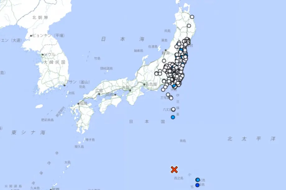
In its original earthquake notice, issued at 11:17 a.m. on October 25, the Japan Meteorological Agency located the epicenter west of the Ogasawara Islands at 28.0 degrees north latitude and 139.9 degrees east longitude. The notice listed a magnitude of 7.0, a depth of about 470 kilometers and a maximum seismic intensity of 3 at Ogasawara village. Its tsunami statement read: "There is no concern about a tsunami from this earthquake."
The strongest recorded shaking reached 3 on Japan's seismic intensity scale, which runs from 0 to 7, on the inhabited islands of Chichijima and Hahajima. No casualties or damage were immediately reported. Authorities continued monitoring seismic activity for possible aftershocks.
The U.S. Geological Survey measured the earthquake at magnitude 6.5 and a depth of 492.4 kilometers. Both agencies placed its origin hundreds of kilometers below the ocean, making depth a central part of the explanation for an earthquake that produced relatively modest shaking over a large area.
Municipalities recording an intensity of at least 1 had a combined population of 34,539,637, according to a calculation using national population statistics from January 2025. Of those residents, 8,916,834, or 25.8 percent, were aged 65 or older. Those figures describe the population living in places where instruments registered shaking strong enough to be felt.
The Ogasawara Islands, also called the Bonin Islands, lie far south of mainland Tokyo and are administered by the Tokyo Metropolitan Government. The island group has approximately 2,500 residents. Sunday's earthquake connected that remote Pacific community with a much larger stretch of Japan through seismic waves traveling deep underground.
Japan's weather agency placed the earthquake about 1,000 kilometers south of Tokyo. USGS location information also put the epicenter 729 kilometers south southeast of Kushimoto and 807 kilometers south of Shizuoka, illustrating how far offshore the event occurred.
Why the magnitude figures are different
The Japan Meteorological Agency's preliminary magnitude of 7.0 and the USGS measurement of 6.5 describe the same earthquake. The European Mediterranean Seismological Centre initially gave a magnitude of 6.3 and subsequently listed 6.5, matching the USGS figure.
Magnitude estimates are calculated from seismic recordings. Monitoring agencies can use different sets of instruments and calculation methods, and early estimates can change as more recordings become available. For readers following updates, the useful approach is to keep each figure attached to the agency that issued it.
Depth estimates also varied. Japan's agency put the origin at about 470 kilometers, while the USGS gave 492.4 kilometers and the China Earthquake Networks Center gave 480 kilometers. Each measurement places the earthquake far below the shallow crust where many damaging earthquakes begin.
Magnitude and intensity answer different questions. Magnitude describes the size of an earthquake at its source. Intensity describes the shaking at a particular location, so one earthquake can produce many intensity readings across different towns and islands.
Where the shaking was recorded
Ogasawara village recorded the maximum intensity of 3. On the mainland, intensity 2 was measured in Tokyo's Chiyoda ward, parts of Yokohama and Kawasaki, and municipalities across several prefectures, including Miyagi, Fukushima, Ibaraki, Tochigi and Saitama.
Chiba prefecture recorded intensity 2 in Katori, Mutsuzawa, Ichihara, Urayasu, Tateyama and other municipalities, as well as Chiba city's Chuo and Mihama wards. Many other parts of the prefecture recorded intensity 1.
Weaker shaking extended farther across the country. Intensity 1 readings included Morioka in Iwate prefecture and Hashikami in Aomori prefecture to the northeast, along with locations in Niigata, Yamanashi, Nagano and Shizuoka. Much of central Tokyo also registered intensity 1.
The pattern shows why distance from the epicenter alone gives an incomplete picture of what residents experience. Seismic waves travel through different materials underground, while local ground conditions can affect the shaking recorded at the surface.
How a deep earthquake reached distant cities
The Ogasawara Islands sit in the Izu-Bonin-Mariana region, where the Pacific plate moves beneath the Philippine Sea plate. A tectonic plate is an enormous moving slab of the Earth's outer layers. Where one plate sinks beneath another, earthquakes can occur far below the surface.
Sunday's tremors are believed to have spread through the descending Pacific plate, helping the shaking reach distant parts of eastern and northeastern Japan. The earthquake's depth meant that even communities near the point directly above its origin were separated from it by hundreds of kilometers of rock.
The epicenter is the point on the Earth's surface directly above where an earthquake starts. The actual starting point is underground. That difference matters here: describing an epicenter as being offshore does not tell readers how far beneath the seabed the rupture occurred.
Ogasawara has produced a striking example before. In 2015, a magnitude 7.9 earthquake at a depth of 664 kilometers was felt across almost all of Japan. Elevators stopped in Tokyo, although no one was killed. That earthquake originated about 172 kilometers deeper than Sunday's event, using the USGS depth for the latest quake.
The 2015 event provides a concrete comparison for the broad reach of Sunday's tremors. A remote origin and great depth can still be associated with shaking in cities far from the island chain.
Japan and Hawaii faced no tsunami threat
The Japan Meteorological Agency said the earthquake posed no tsunami threat. The Pacific Tsunami Warning Center also issued a bulletin at 02:24 UTC on October 25 stating that there was no tsunami threat. The U.S. National Weather Service confirmed that Hawaii was not under a tsunami watch.
Tsunamis are generated when a disturbance displaces a large volume of water. In earthquakes, that commonly happens when movement near the ocean floor lifts or lowers the seabed. Sunday's earthquake began hundreds of kilometers beneath it, and the agencies assessing the event issued no tsunami warning.
The sequence of earthquake recordings and tsunami assessments was:
- 02:09 UTC on October 25: The USGS recorded the earthquake, corresponding to about 11:09 a.m. in Japan.
- About 11:10 a.m. in Japan: The Japan Meteorological Agency's initial account placed the earthquake west of the Ogasawara Islands, with a preliminary magnitude of 7.0.
- 02:24 UTC: The Pacific Tsunami Warning Center issued its bulletin stating there was no tsunami threat.
Hawaii was still on Saturday, October 24, when the earthquake occurred, at about 4:09 p.m. local time. Japan was already on Sunday morning. The different calendar dates in earthquake notices reflect the time zones on opposite sides of the Pacific.
What the damage assessment says
The USGS issued a Green alert for estimated deaths and economic losses from shaking, indicating a low likelihood of casualties and damage. That assessment was consistent with the initial absence of reported injuries or material damage.
A Green alert is an early estimate based on the earthquake and expected exposure to shaking. Confirmed information about individual buildings and communities comes through local assessments. A final damage assessment was not yet available.
The USGS assessment described much of the region's building stock as resistant to earthquake shaking, while identifying vulnerable construction types, including heavy timber frames and reinforced or confined masonry. Masonry buildings use materials such as brick or concrete blocks; confined masonry includes supporting concrete elements around the walls.
The population calculation helps explain the scale of the earthquake's reach alongside those low estimated losses. More than 34.5 million people lived in municipalities with intensity readings of at least 1, but the highest recorded intensity anywhere was 3. A large geographic footprint and strong local shaking are different features of an earthquake.
Residents aged 65 or older represented just over one quarter of the population in those municipalities. That age breakdown is useful for planning assistance and communication, particularly where people may need help moving around or checking their homes after shaking.
Japan's earthquake history gives the event context
Japan lies where four major tectonic plates meet and experiences about 10 percent of the world's earthquakes of magnitude 6 or higher. Sunday's event occurred within that active setting, but its great depth and the absence of a tsunami shaped the immediate consequences for residents.
The magnitude 9.0 earthquake and tsunami of March 2011 demonstrate how destructive a different combination of earthquake size, location and seabed movement can be. The disaster left 22,303 people dead or missing when deaths from disaster related causes are included, and it triggered the Fukushima nuclear plant disaster.
For Sunday's earthquake, the main developments were more limited: shaking across a wide area, no tsunami threat in Japan or Hawaii, and no immediate reports of casualties or damage. Authorities continued watching for further seismic activity while the initial assessments pointed to a low likelihood of serious losses.
Key Points
- The earthquake struck west of the Ogasawara Islands at about 11:10 a.m. Japan time on October 25, 2026.
- Japan's weather agency estimated magnitude 7.0 at a depth of about 470 kilometers; the USGS recorded magnitude 6.5 at 492.4 kilometers.
- The maximum seismic intensity was 3 on Chichijima and Hahajima, with weaker shaking across eastern and northeastern Japan.
- Municipalities recording intensity 1 or higher had a combined population of about 34.5 million.
- Japanese and Pacific tsunami authorities said there was no tsunami threat, and Hawaii was not under a tsunami watch.
- No casualties or damage were immediately reported, and the USGS issued a Green alert indicating a low likelihood of losses.