Rain above 100 millimetres forecast as storm develops
Sri Lanka's Department of Meteorology has forecast rainfall exceeding 100 millimetres in some areas and warned fishing vessels away from a large section of the Bay of Bengal as a depression is expected to strengthen into a severe cyclonic storm by the morning of October 27, 2026.
Contents
- Rain above 100 millimetres forecast as storm develops
- How the system is expected to strengthen
- Where the heaviest rain is expected
- How the forecast changed from October 24
- Strong winds extend beyond the rain warning areas
- Fishing vessels told to avoid specified Bay of Bengal waters
- Rough seas forecast around much of Sri Lanka
- India faces a possible coastal crossing on October 28
- Key Points
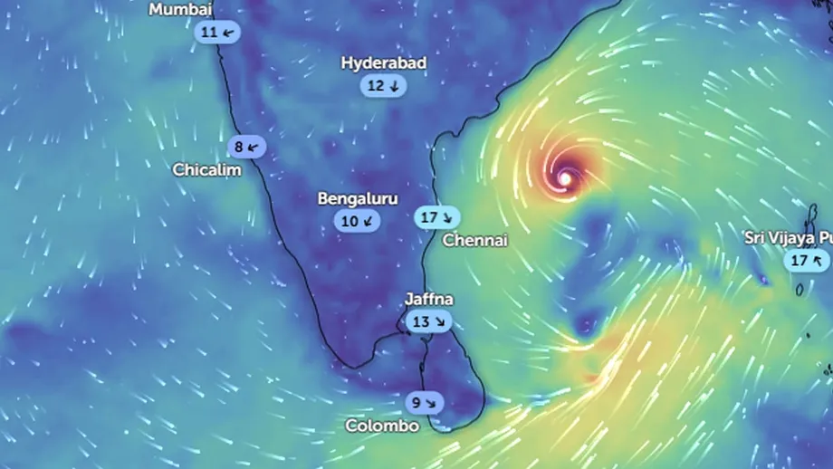
The department's forecast, issued at 5:30 a.m. on October 25, places the system near the North Andaman Islands. At 11:30 p.m. on October 24, its centre was near latitude 15.5 degrees north and longitude 91.0 degrees east. It was expected to become a deep depression on October 25, a cyclonic storm by the following morning and a severe cyclonic storm over the west central Bay of Bengal on October 27.
Sri Lanka is expected to experience increased rain as winds flowing toward the system extend across the island, particularly its southwestern regions. The storm itself is not expected to strike the country directly. At sea, the warning is more extensive: fishing and naval communities have been told to avoid specified waters until further notice, while vessels already there should move to safer areas.
The department, Sri Lanka's national weather forecasting authority, explained the connection between the distant system and local rainfall:
Although this system is not expected to have a direct impact on Sri Lanka, an increase in rainfall is expected over the southwestern parts of the island during the next few days, as the wind flow associated with the system extends across the island.
For residents, the immediate concerns are periods of heavy rain, lightning and strong winds. For crews offshore, the forecast also includes rough seas, waves reaching about 2.5 metres in some waters and temporary thunderstorm gusts of up to 70 kilometres per hour.
How the system is expected to strengthen
The depression developed from an area of low atmospheric pressure near the North Andaman Islands. A depression is an organised weather system with winds circulating around an area of lower pressure. The terms deep depression, cyclonic storm and severe cyclonic storm describe successive stages of increasing strength.
The Department of Meteorology expects the system to move toward the west northwest across the Bay of Bengal. Its forecast sets out the following sequence:
- October 24, 11:30 p.m.: The depression was centred near 15.5 degrees north and 91.0 degrees east.
- October 25: It was expected to become a deep depression while moving over the east central and adjoining southeastern Bay of Bengal.
- October 26, morning: It was forecast to strengthen into a cyclonic storm.
- October 27, morning: It was expected to reach severe cyclonic storm strength over the west central Bay of Bengal.
- October 28: Forecasts for India indicated a possible coastal crossing, with the more detailed projection placing landfall between Bapatla and Visakhapatnam.
These dates describe the predicted development of the system. Sri Lanka's rain and marine warnings apply while it is still offshore, because the surrounding wind flow reaches much farther than the storm's centre.
Where the heaviest rain is expected
The October 25 forecast calls for showers or thundershowers at times in the Western, Sabaragamuwa, Southern, Northwestern and Northern provinces. Kandy, Nuwara Eliya and Anuradhapura districts are also included, with rainfall above 100 millimetres possible at some locations across these areas.
Rainfall of 100 millimetres means enough water to form a layer 10 centimetres deep on a flat surface if none drains away, soaks into the ground or evaporates. The department identifies the possibility of such totals at particular places within the warning areas, rather than forecasting the same amount for every town.
Uva province and the Ampara and Batticaloa districts have a different timing pattern. Showers or thundershowers are expected at several places after 1:00 p.m., making the afternoon forecast especially relevant to people travelling or working outdoors there.
How the forecast changed from October 24
The department's forecast issued at 5:30 a.m. on October 24 had already warned that the system would bring more rain to southwestern Sri Lanka. At that stage, the area of low pressure was expected to become a depression during the day, then a deep depression by October 25 and a cyclonic storm by the morning of October 26.
The earlier forecast identified the Western, Sabaragamuwa, Northern and Northwestern provinces for intermittent showers or thunderstorms. It also anticipated afternoon showers elsewhere, with rainfall exceeding 50 millimetres possible in some areas.
By October 25, the depression had formed and the forecast included severe cyclonic storm strength on October 27. The rainfall warning specified possible totals above 100 millimetres and included the Southern province and the districts of Kandy, Nuwara Eliya and Anuradhapura.
The October 24 forecast also mentioned possible early morning mist in parts of the Central and Uva provinces. The developing weather therefore involves different conditions at different times: mist in some highland areas, afternoon thunderstorms in others and intermittent rain across the provinces named in the latest bulletin.
Strong winds extend beyond the rain warning areas
Winds of about 40 to 50 kilometres per hour are expected at times over the western slopes of the central hills, the Northern, North Central and Northwestern provinces, and the districts of Trincomalee, Hambantota and Matale.
The wind warning has a different geographical reach from the list of places facing the heaviest rain. Trincomalee, Hambantota and Matale are specifically named for strong winds, while the afternoon thunderstorm forecast singles out Uva, Ampara and Batticaloa. Residents need to check both parts of the forecast for their location.
The department also advises the public to take precautions against lightning and temporary localised strong winds during thundershowers. Those sudden winds can occur around an individual thunderstorm as well as within the wider flow associated with the Bay of Bengal system.
People in the affected areas have been urged to monitor changing conditions and follow subsequent official weather advisories. The warning covers the next few days, during which the system is expected to strengthen and move across the bay.
Fishing vessels told to avoid specified Bay of Bengal waters
The Department of Meteorology has warned fishing and naval communities against entering deep sea areas bounded by latitudes 10 degrees north and 20 degrees north, and longitudes 80 degrees east and 95 degrees east. The instruction applies until further notice.
Vessels already operating inside those boundaries have been advised to move to safer waters. The warning is particularly relevant to fishing boats that spend several days offshore, where decisions about routes and the return journey must account for the developing system.
The coordinate boundaries identify a broad area of the Bay of Bengal for navigators. Latitude describes a position north or south of the equator; longitude describes a position east or west around the Earth. Together, the four limits outline the waters covered by the warning.
The department has asked fishing and naval communities to pay attention to future forecasts and bulletins. No date has been given for lifting the warning, so crews need to follow later instructions before planning to reenter the affected waters.
Rough seas forecast around much of Sri Lanka
Southwesterly winds around the island are forecast at 30 to 40 kilometres per hour. They may rise to 50 to 60 kilometres per hour at times in waters off the coast from Trincomalee to Pottuvil, along the route through Kankasanthurai, Puttalam, Colombo, Galle and Hambantota.
That route follows much of Sri Lanka's northern, western and southern coastline before reaching the southeast. Seas along it are expected to become rough at times, while other waters around the island may be fairly rough.
Waves may reach about 2.0 to 2.5 metres in waters from Puttalam to Pottuvil through Colombo, Galle and Matara. Showers or thundershowers are also expected at several places in the seas surrounding Sri Lanka.
During thundershowers, temporary gusts could reach 60 to 70 kilometres per hour and seas could become very rough. The highest thunderstorm gust forecast is therefore 30 kilometres per hour above the upper end of the usual 30 to 40 kilometre per hour marine wind forecast, showing how quickly conditions around a vessel could worsen.
India faces a possible coastal crossing on October 28
India's eastern coast faces the prospect of a more direct encounter with the developing storm. The India Meteorological Department placed the system about 440 kilometres north northwest of Sri Vijaya Puram in the Andaman Islands during an early morning assessment.
A detailed forecast projected landfall between Bapatla and Visakhapatnam in Andhra Pradesh during the forenoon of October 28, with sustained winds of 115 to 125 kilometres per hour and gusts reaching 140 kilometres per hour. A broader projection from the IMD's Bhubaneswar Meteorological Centre placed the coastal crossing along the southern Odisha and northern Andhra Pradesh coast by October 28.
Forecasts also indicated that the system could reach very severe cyclonic storm strength by October 28. The precise coastal crossing point and final intensity remain forecast details that may change as the system develops.
Sri Lanka and India therefore face different parts of the same weather system. Sri Lanka's warning centres on increased rainfall, strong winds and hazardous seas as air flows toward the depression. The Indian coastal forecast includes the possibility of the storm's centre coming ashore with much stronger winds.
Key Points
- Sri Lanka's October 25 forecast expects the Bay of Bengal depression to become a severe cyclonic storm by the morning of October 27.
- The system is not expected to strike Sri Lanka directly, but its associated winds are forecast to increase rain, particularly in the southwest.
- Rainfall above 100 millimetres is possible in parts of five provinces and in Kandy, Nuwara Eliya and Anuradhapura districts.
- Uva, Ampara and Batticaloa are forecast to experience showers or thunderstorms after 1:00 p.m.
- Fishing and naval communities should avoid the specified Bay of Bengal waters until further notice; vessels already there should move to safer areas.
- Marine thunderstorm gusts may reach 70 kilometres per hour, while waves in some coastal waters may reach 2.5 metres.
- Forecasts indicate a possible coastal crossing in eastern India on October 28.