87 projects face a test beyond construction
Ho Chi Minh City plans to invest more than VND142 trillion in 87 flood control projects during 2026-2030, targeting 50 flood locations across an expanded city with 159 recorded hotspots. The programme brings together drainage upgrades, canal improvements, tidal barriers and water storage, with success depending on how well those parts work together.
Contents
- 87 projects face a test beyond construction
- Where the 159 flood hotspots are
- Rain and tides exceed older design conditions
- Why the city is looking at 23 drainage basins
- What is scheduled for 2026 and beyond
- Tidal gates need somewhere for rainwater to go
- Making room for water in a growing city
- Residents need relief during construction too
- How to judge whether the spending works
- Key Points
The detailed investment figure is VND142.34 trillion. For 2028-2030 alone, the city plans 33 projects costing VND73 trillion to tackle 17 severe flood locations. That represents about 51 percent of the programme's total proposed spending, putting a large share of the investment in its final three years.
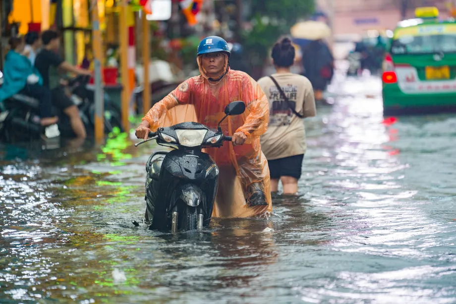
Residents need that spending to translate into shorter floods, safer journeys and fewer losses. On September 30, 2026, an 800 metre stretch of Phan Huy Ich Street was submerged under water approaching a metre deep, according to the Center for Transport and Technical Infrastructure Management. The street received 79 millimetres of rain in just 45 minutes.
Phuong Thanh, a 33-year-old resident of Phuc Yen 1 Apartment Building on the street, described the conditions that led her to leave her motorbike at a shop and walk home:
The water reached an adult's waist,
The street illustrates the challenge facing the investment programme. Water arrives from several smaller drainage basins, passes through ageing pipes into Hy Vong Canal, then continues toward Tham Luong-Ben Cat Canal. Narrow drains and a deteriorated, encroached canal restrict that journey. Improving one flooded stretch requires attention to the route beyond it.
Where the 159 flood hotspots are
The Department of Construction records 76 flood hotspots in the former Ho Chi Minh City area, 52 in former Binh Duong and 31 in former Ba Ria-Vung Tau. The two newly incorporated areas together account for 83 locations, slightly more than half the citywide total.
Within the former city, 57 hotspots are in the older inner urban area and 19 are in former Thu Duc. The inner urban area's total includes 48 locations affected by rain and nine by tides, with tidal flooding concentrated mainly in southern neighbourhoods and along rivers.
The department's severity breakdown lists 39 locations with frequent flooding, 33 with moderate flooding and 22 with light flooding. Another 65 remain unclassified, including the 52 in former Binh Duong. Frequent flooding in that breakdown means water deeper than 30 centimetres persisting for more than 120 minutes.
A later account of the department's programme identifies 50 severe hotspots, compared with the 39 frequently flooded locations in the earlier breakdown. Another description uses a shorter threshold of water at least 30 centimetres deep remaining for more than 30 minutes. The classification and reporting dates therefore matter when comparing the totals. The programme also describes its target as 50 locations, each of which may contain several individual flood points.
Fifteen locations with frequent flooding from rain are concentrated in Dong Hung Thuan, Thong Tay Hoi, An Hoi Dong, Thanh My Tay and Binh Tri Dong wards. These concentrations make detailed local surveys essential to deciding which projects should come first.
Rain and tides exceed older design conditions
The Department of Construction said at an October 8 briefing that existing drainage was designed around rainfall of 85.3 millimetres over three hours and a tidal level of 1.32 metres. Recent storms have exceeded those conditions, while tides at Phu An station have reached 1.75 metres on several occasions.
The September 30 rainfall on Phan Huy Ich Street delivered almost the older design's entire three-hour rainfall amount in only 45 minutes. Water arriving that quickly creates a much sharper surge through street inlets, pipes and canals.
Nguyen Phu Quynh, deputy director of the Southern Institute of Water Resources Research, says flooding results from the combined effects of extreme rain, tides, river flows, land subsidence and urban development. Infrastructure designed for conditions 20 to 30 years ago may now face different river levels and ground elevations.
Subsidence means the ground is sinking. A drain that once sloped sufficiently toward an outlet can lose some of that slope as land settles unevenly. High river levels create another difficulty by reducing the ability of water inside the city to flow out naturally.
Khuong Van Muoi, former chairman of the Ho Chi Minh City Association of Architects, says drains can continue carrying water while lacking the capacity to clear it quickly enough. His recommended response is to check each area's capacity, blockages and incoming flows before choosing a remedy.
Why the city is looking at 23 drainage basins
Ho Chi Minh City has 23 main drainage basins, according to Le Ngoc Linh, deputy director of the Department of Construction. A basin is an area whose rainwater follows connected routes toward a shared outlet. Its boundaries follow the land and waterways rather than ward or district borders.
Architect Nguyen Dinh Hoa, of the Ho Chi Minh City Institute of Economics and Management, proposes a shared map showing ground elevations, drainage directions, water storage areas, system capacity and bottlenecks. Updated and checked data would support project selection, design and assessment.
Pham Viet Thuan, director of the city's Institute of Natural Resources Economics and Environment, proposed surveying all 159 hotspots at an infrastructure workshop on October 16. His proposal includes measuring elevations and flow directions, digitising the findings and considering ecological lakes where major flood locations cannot drain adequately.
Linh says the 2026-2030 work needs to identify narrowed drainage routes, sections that have lost slope through subsidence, sediment accumulation and outlets affected by high tides. These are different problems requiring different responses, even when they produce similar scenes of water covering a road.
The network is extensive: about 7,200 kilometres of drainage pipes, 1,700 outlets, more than 500 tidal control valves and nearly 1,000 kilometres of canals and waterways. Much of that infrastructure is concentrated in the former city and developed under Plans 752 and 1547, which addressed drainage and canal improvements alongside embankments and tidal barriers.
What is scheduled for 2026 and beyond
The People's Committee's 2026 Drainage and Flood Control Plan targets completion of nine projects worth more than VND7.15 trillion. Trinh Quoc Dung, deputy head of the Department of Construction's Technical Infrastructure Division, says the city is monitoring progress toward completion within 2026.
Three projects in the central urban area, worth nearly VND1.343 trillion, include work intended to resolve flooding on Phan Van Hon and Binh Quoi streets and protection against riverbank erosion on the Thanh Da peninsula.
Four projects in former Binh Duong, worth more than VND5.437 trillion, include drainage associated with roads DT.748 and DT.744, drainage for Di An and Tan Dong Hiep Industrial Park, and reinforcement along the Saigon River. A main drainage line along National Highway 51 in former Ba Ria-Vung Tau, costing about VND366 billion, is also scheduled for completion.
The main milestones and differing planning horizons are:
- 2016: Construction began on the VND10 trillion tidal control project, which remains incomplete in the latest account.
- 2026: Nine projects are targeted for completion. Three flood locations identified for relief are Phan Van Hon, Binh Quoi and the National Highway 51-Huynh Thuc Khang area.
- 2026-2030: The wider programme proposes 87 projects targeting 50 flood locations.
- 2028-2030: A group of 33 projects worth VND73 trillion is planned to address 17 severe hotspots.
- 2050: Department director Tran Quang Lam also cited a goal of resolving 50 major flood points at the October 16 workshop. How that longer horizon relates to the 2030 programme has not been explained.
Canal works at Tham Luong-Ben Cat, Xuyen Tam and Van Thanh form part of the wider effort. Plans also include restoring water storage areas and relocating homes along canals through about 43 projects, alongside improvements to waterways and public spaces.
Tidal gates need somewhere for rainwater to go
The VND10 trillion tidal control project includes six major gates and embankments along the Saigon River. It is expected to protect around 6.5 million people and address eight tidal flood hotspots when the system is complete.
Quynh says connected embankments, revetments and gates are essential to obtaining the intended benefit. He described the remaining requirement:
The project will struggle to reach its full potential without connecting infrastructure to create a continuous tidal-control belt in the area.
Closing a gate can keep high river water outside a neighbourhood, while rain continues falling inside it. Pumps, canals and storage basins must then handle that rainwater until conditions allow discharge. Linh says tidal infrastructure needs to operate as part of each basin's full water management system.
Professor Nguyen Van Phuoc, associated with the city's Union of Science and Technology Associations, proposes coordinating gate operations with rainfall forecasts, water levels, salinity, available storage and water supply needs. He also recommends coordination with Dau Tieng and Tri An reservoirs in the Dong Nai-Saigon river system to support freshwater supplies and manage saltwater intrusion.
Making room for water in a growing city
Phuoc proposes a sponge city approach: keeping conventional drains, barriers and pumps while adding places where water can soak into the ground or remain temporarily. Parks, rain gardens, planted roofs, ponds and protected river corridors would help reduce the rush into pipes during storms.
His proposals vary by location. Dense central neighbourhoods could use underground storage beneath parks and squares. New urban areas could reserve land for ponds and permeable surfaces at the planning stage. Agricultural areas could protect low fields and irrigation channels, while coastal areas could retain mangroves and tidal flats.
Nguyen Dinh Hoa recommends marking important storage areas, low ground and drainage corridors on planning maps and protecting them through land use controls. Raising roads, filling land and narrowing canals can redirect water toward neighbouring communities, so he calls for assessing the combined effect of developments within each basin.
Phuoc also proposes requiring developments to keep runoff after construction no greater than before construction, or provide enough additional storage to compensate. Runoff is rainwater flowing across the surface instead of soaking into soil. This would make water management part of development approval rather than a repair task after flooding begins.
Architect Ngo Viet Nam Son, chairman of NgoViet Architects & Planners, calls for reserves beyond a chosen design storm. If planners use rainfall of 100 millimetres as a baseline, he says, they should also prepare for heavier events. Applying storage and infiltration measures requires attention to available land, groundwater levels and building density.
Residents need relief during construction too
Pham Quoc Huy, deputy head of the Department of Construction's Technical Infrastructure Division, says construction can temporarily obstruct drainage. Work on Tham Luong-Ben Cat Canal and drainage along Le Van Tho and Nguyen Van Khoi streets has at times required flows to be blocked. He also identifies inconsistent operation of drainage systems in some localities.
Nearer term measures proposed by specialists include clearing pipes and canals, removing construction bottlenecks, checking connections and deploying supporting pumps where unexpected flooding occurs. The 2026 plan also prioritises repairs, dredging, tidal flap gates and effective pumping station operation.
The consequences extend beyond journeys through flooded streets. At Thu Duc market, stallholder Ngo Thi Van says heavy rain lasting about half an hour can bring water above knee level and keep customers away. At CityLand Park Hills, office tenant Nguyen Dang Thong described flooding that threatened electronic equipment in an area he said had previously escaped similar conditions.
Le Thi Phuong, a trader in Tan Thuan ward, says tidal flooding brings business almost to a halt. In neighbourhoods facing deeper and more dangerous floods, Hoa recommends considering infrastructure upgrades, changes to building density, drainage corridors or relocation where necessary, with livelihoods, residents' rights and access to essential services included in decisions.
How to judge whether the spending works
Phuoc recommends measuring protected land and population, traffic disruption, avoided economic losses, water quality and operating costs throughout each project's life. Those measures would show whether investment is improving daily life across a basin, alongside changes in flood depth and duration.
He proposes giving hospitals, airports, ports, control centres and essential transport routes stronger protection. Some parks, squares and sports grounds could instead be designed to hold water temporarily during heavy rain, directing storage toward spaces prepared for it.
A proposed digital twin would bring rainfall, tide, salinity, flood camera, drainage, pump, subsidence and traffic data into a computer model of the city's water system. Operators could use it to anticipate trouble and coordinate gates, pumps and storage before a storm. Phuoc also proposes independent review of flood programmes through the Ho Chi Minh City Union of Science and Technology Associations.
The investment choices also need named operators, maintenance funding and responsibility after construction, according to recommendations accompanying the programme. For households and businesses, the practical result will be measured after rain and high tides: how deep the water becomes, how long it stays and how quickly normal life resumes.
Key Points
- Ho Chi Minh City proposes 87 flood control projects costing VND142.34 trillion during 2026-2030.
- The expanded city has 159 recorded flood hotspots across the former Ho Chi Minh City, Binh Duong and Ba Ria-Vung Tau areas.
- Nine projects worth more than VND7.15 trillion are targeted for completion in 2026.
- The city has 23 main drainage basins, making connections between drains, canals, gates, pumps and storage central to the programme.
- Specialists propose protecting space for water, tightening development requirements and measuring reductions in flood depth, duration and losses.